Showing 8459 items
matching snowy-river-dry-cleaners
-
 Bright & District Historical Society operating the Bright Museum
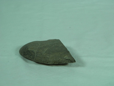
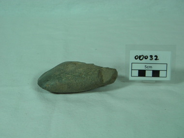
Axe Stone
Presence of Aboriginal people and their activities in Buffalo RiverAboriginal axes are relatively uncommon in North East Victoria and provide evidence of presence and exploitation of resourcesground edge stone axe with some edge damage and edge polish on working edge and flat opposite edge. axe, aboriginal artefact, buffalo river -
 Phillip Island and District Historical Society Inc.
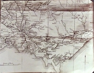
Photograph, Rail Lines of Victoria, Early to mid 20th century
Map showing extensive railway network in Victoria in early C20th.Sepia photo of map of Victoria showing rivers and railway lines and stations.Names of towns, rivers, bays etcsepia photograph, rail transport, victoria, map -
 Port Fairy Historical Society Museum and Archives
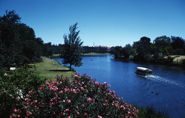
Photograph
Moyne River Scene January 1944 Subjects unknownBlack and white photograph of Two ladies at stern of boat fishingmoyne river, fishing, port fairy, boat -
 Orbost & District Historical Society
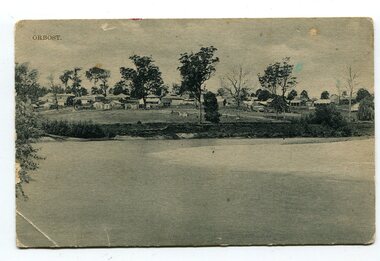
black and white photograph, Campbell. D.S, late 19th century ?
This is a photograph of the settlement of Orbost on the banks of the Snowy River,. In the foreground in the paddock there is a water trough (Bills?) and the B Drain can be seen on the far left. D.S. Campbell had a stationery store in Nicholson Street Orbost and published several black and white postcards of Orbost.This is a pictorial record o The township of Orbost in the late 19th century.A black / white photograph / postcard. There is a river in the foreground with houses and shops in the background behind a cleared paddock.on front - Orbostorbost-19th-century snowy-river -
 Greensborough Historical Society
Map, Heidelberg. Historic River Landscape Assessment. Historical maps: Map C 1851-1863. "The Garden of the colony", 1985c
Geographical area of around 35 sq. kilometres marked with physical features such as major roads, vegetation and properties, with locations and notes of the increasing number of farms, gardens orchards and vineyards which had become established in addition to pastoral runs. Bounded by Shire of Diamond Valley to the North, Darebin Creek to the West and Plenty River to the East.Black and white sketch map on white paperheidelberg, heidelberg - maps -
 Kew Historical Society Inc
Photograph - Submerged houses in River Avenue, North Kew, 1934
North Kew, now divided between Kew and Kew East, bordered the Yarra River. As such, it was a region subject to flooding in the Yarra Valley. Development beyond this point (ie Kellett Grove) was limited by the City of Kew's planning regulations. Prior to urban development, the area since European settlement and the first land sales in the district in the 1840s, had been used for dairy farming. Vivid photograph contrasting domestic life and relationships with natural disasters such as the flood of 1934.Small sepia snapshot of two submerged houses belonging to local families in River Avenue, North Kew, during the 1934 floods. The view is presumably from near Kellett Grove looking north towards Fairfield.Verso: COES & HYATTS ROOF / RIVER AVENUE / Stamped: 6414yarra river -- north kew, floods -- yarra valley, floods -- north kew, floods -- 1934, natural disasters -- kew -
 Orbost & District Historical Society
black and white photographs, Jude, Ray, 1915 - 1969
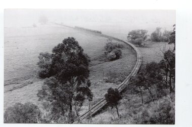
These photographs relate to the East Gippsland Railway. The Bairnsdale-Orbost railway was opened in 1916 to serve the agricultural and timber industry. Because of the decline in traffic and heavy operating costs, the line was finally closed in August, 1987. Orbost Railway Station was opened on Monday 10 April 1916 as the terminus of the Orbost railway line, and closed in 1987. The station was located on the west side of the Snowy River despite the town of Orbost being on the east side of the river, in order to save on the costs of a bridge over the river, which at the time had highly variable levels. These photographs are associated with the history of the Orbost-Bairnsdale railway line and therefore reflects the role that the rail line played in the social and economic history of Orbost.Seven black / white photographs and one postcard print.3103.1 on back - " Orbost- Snowy River flats viaduct 22-2-1964 ARHS special train Ray Jude photo" 3103.2 - on back -" Orbost Snowy River flats viaduct A.R.H.S. special train 22.2.1969" 3103.3 - on back - " A.R.H.S. special across bridge between Waygara & Nowa Nowa 22-2-1964 3103.4 - on back - " Nowa Nowa Boggy Creek Bridge A.R.H.s. Orbost tour Ray Jude photo" 3103.5 - on back - " Orbost 22-2-1969 SM office & goods shed Ray Jude photo" 3103.6 - on back - " Orbost Railway Yards - 22 February 19369 Ray Jude photo" 3103.7 - on back - " Orbost May 27 -1936 Orbost Rail Station" 3103.8 - on front - caption - Unloading Ballast Orbost line near Newmerella 1915 - J. Sullivan Colin ?orbost-railway east-gippsland-railway bairnsdale-orbost-railway -
 Lakes Entrance Historical Society
Book, Coates Rhonda B, McKillops Bridge by Rhonda Coates
A lively account of the planning,construction,and celebration of the bridge over the Snowy River at Deddick, previously the major river crossing between the Monaro and East Gippsland, first by foot or horseback then ferry or punts.bridges, waterways -
 Melbourne Tram Museum
Postcard, Rose Stereograph Co, "A delightful view across the River Yarra, Melbourne"
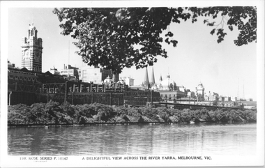
Rose Series postcard No. P 10147, titled "A delightful view across the River Yarra, Melbourne" showing a view from the south bank of the Yarra across to Flinders St station, the signal gantries at the west end of the platforms, the station buildings and some of the other buildings on the skyline. A St Kilda bound dog box (swing door) set is in platform 10 awaiting departure.Yields information Flinders St station from the south side of the river.Postcard - printed real photograph with Rose Stereograph Co. name on the rear.flinders st station, signals, yarra river, railways, electric trains -
 Port Fairy Historical Society Museum and Archives
Photograph
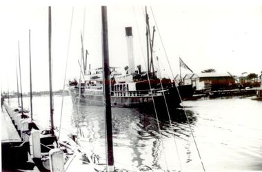
Iron Steamship SS Casino in the Moyne River (sank at Apollo Bay in 1932)Black & white photograph of ship near wharfboat, sea, river, ss casino, moyne river, steamer -
Lakes Entrance Historical Society
Postcard - Marlo on the Snowy, 1905 c
Black and white postcard of the wharf and goods shed, boats moored at jetty, sand dunes in distance at Marlo on the Snowy River Victoriawaterways, beaches, wharfs, boats and boating -
 Bendigo Historical Society Inc.
Slide - VAL DENSWORTH COLLECTION: DRY LAKE EPPALOCK, May 2004
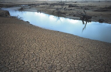
Slide. Dry Lake Eppalock. The Campaspe River flowing so slowly through Lake Eppalock.slide, bendigo, dry lake eppalock., dry lake eppalock. -
 Mission to Seafarers Victoria
Photograph - Photograph, Black and white, Allan Charles Quinn, Finn Boda, Stockholm, 18 May 1949
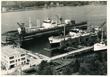
The photograph is part of a series of six, depicting the Fenris in dry docks in at Finn Boda ship yards, in Stockholm, Sweden, between the 4th and the 27th of May, 1948. This photograph shows the dry docks themselves, including the Fenris and another ship.This is a photograph from the Allan Charles Quinn collection which is a collection of letters and photograph depicting aspects of life at sea for a young man in the era immediately following World War II.A black and white photograph of the Finn Boda dry dock, in Stockholm, dated 18-5-49.Reverse: FINN BODA STOCKHOLM / 18-5-49 handwritten in blue ink. There is an indecipherable mark below this.allan-quinn, photograph, fenris, dry-dock, sweden, stockholm, 1949, finn boda -
 Greensborough Historical Society
Photograph - Digital Image, Cherel Sartori, Looking east from Henry Street to the river 1956, 01/01/1956
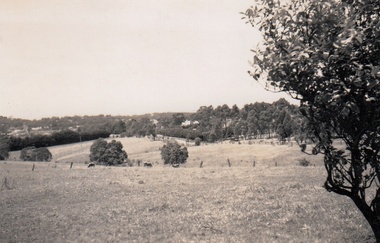
Looking from Henry Street east to the Plenty River, 1956. The house was built 1917, at 112 Henry Street Greensborough by William Mitchell on the 60 acre dairy farm owned by Ethel and Walter Kell. This collection of photographs was copied by Cherel Sartori (who owned the house from 1990-2000), following a visit by Claude Amiet who lived in the house as a child in the early 20th century.An indication of the rural aspect of this area in the mid-20th century.Digital copy of black and white photographkell's cottage, claude amiet, cherel sartori -
 Vision Australia
Photograph - Image, Lifetime, Association for the Blind : Vision Victoria River Run Perpetual Shield
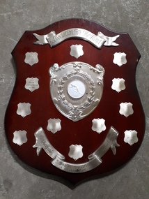
A brown wooden award with a banner engraved 'Association for the Blind' at the top of the shield, a large metal plate with a laurel wreaths and relief of a man starting to run in the middle. At the base is another banner inscribed 'Perpetual Shield Vision Victoria River Run'. 12 smaller shields frame the central plate, with names on two of them: 1990 Mike Hillardt 31.39 and 1991 Amon O'Callaghan 31.49. Wooden shield with 12 mini shields, banner and image of runner in centreassociation for the blind, mike hillardt, amon o'callaghan -
 Kew Historical Society Inc
Photograph - Morell Bridge, Yarra River, circa 1953
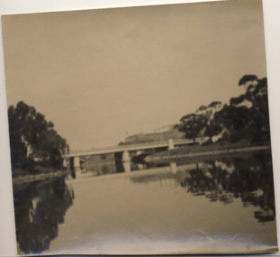
This is one of a series of 17 black and white undated photographic proofs donated to the Kew Historical Society in 2013 by the Queenscliffe Historical Museum. The series includes images of individuals, tea rooms, ferries, motor launches, ocean liners and tugs. Faded black and white photographic positive proof of the Morell Bridge (formerly the Anderson Street Bridge) across the Yarra River near the Botanical Gardens. Princess Bridge can be seen through the arches of the Morell Bridge. The undated photographic positive was probably taken in the 1950s.melbourne, transport, bridges -- yarra river, morell bridge, anderson street bridge, yarra river -
 Bright & District Historical Society operating the Bright Museum
Axe Stone
Evidence of Aboriginal presence and activities in Buffalo River Valley near site of present Buffalo Dam.Evidence of Aboriginal presence and activities in North East and Alpine areas relatively uncommon.quartzite ground edge stone axe with edge damage axe, aboriginal artefact, buffalo river -
 Orbost & District Historical Society
black and white photograph, February 1971
This photograph was taken near the Snowy River Bridge on the the old Princes Highway in Orbost, near the caravan park. The 1971 flood was the the worst flood on record. At Jarrahmond it was at least 11 metres and up to one and a half kilometres wide on the flats causing enormous damage to the flood plain. Records say that "The brown floodwater stain in Bass Strait could be seen from passing airliners." Considerable damage was done to railway infrastructure, roads and farms. More information from the APRIL, 2008 newsletter by John Phillips. (see orbosthistory.com.au)This is pictorial evidence of a significant local event. Floods have been an integral part of Orbost's history for hundreds of years.A black / white photograph of debris, fallen power lines, a tree across the highway and floodwaters across the road.on front at bottom - handwritten in upper case print - " 1971 FLOOD PRINCES HIGHWAY NEAR SNOWY BRIDGE"floods-orbost-1971 -
 Robin Boyd Foundation
Slide, Robin Boyd
Colour slide in a mount. Torrens River, Adelaide, South Australia, AustraliaMade in Australia / Adelaide (Handwritten) / River (Handwritten)adelaide, slide -
 Glenelg Shire Council Cultural Collection
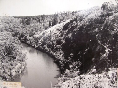
Photograph - Photograph - Jones' Lookout, n.d
Glenelg Shire Council records Portland Development Committee.Photograph of Jones Lookout, Glenelg River.Front: Sticker bottom left. 'Jones' Lookout Glenelg River' - penjones lookout, portland, scenery -
 Orbost & District Historical Society
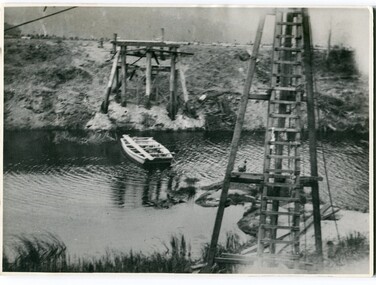
black and white photographs, 1915
This photograph is of the construction of the first road bridge over the Genoa River - 1915. Before today's timber truss and concrete bridge was constructed between 1926-1928 by contractor J.T. Noble Anderson, two earlier bridges crossed the Genoa River at this location. They provided crucial links in the Princes Highway route from Melbourne to Sydney. The letter on the back of the postcard was written by Gordon ? to Alex ? on 2nd October 1917. "this represents the opening of Genoa Bridge. Mrs Alexander cutting the ribbon and Mr Martin holding it at the other side. Did most of the speaking. The gent holding the roll of paper is who came to open the bridge. I can't think of his name. Hubert is standing up at the right / Gordon " This is a pictorial record associated with the history of Genoa in East Gippsland.1100 -A large black / white photograph on a cream coloured buff card. It is of an unfinished bridge with men working there. A small rowboat can be seen on the far side of the river. 1100.1 - A photograph / postcard of the opening of "Genoa Bridge 1917". There is a ribbon stretched across the timber decking road in front of a group of people. 1100.2 - A black / white photograph of a road bridge across a river.on back - "Princes Highway - the 1st bridge over the Genoa River - 1915" on back of 1100.1 is a hand-written letter.genoa-bridge princes-highway-east-gippsland -
 Eltham District Historical Society Inc
Photograph, Fay Bridge, Ancient Eel trap on the Yarra River at Laughing Waters, Eltham - pre-dating European settlement, 6 September 2023
Laughing Waters is the name for a stretch of the Yarra Valley Parklands consisting of river flats and hilly riparian bushland. With Birrarung (Yarra River) flowing through, Laughing Waters has been an important gathering place for thousands of years. For the Wurundjeri, ‘Garambi Baan’ (the name for Laughing Waters in Woi wurrung) is an important site for growing and harvesting food. Significantly, Wurundjeri iuk (eel) traps remain at Garambi Baan to this day. The Wurundjeri Woi Wurrung People take their name from the Woi wurrung language word ‘wurun’ meaning the Manna Gum (Eucalyptus viminalis) which is common along ‘Birrarung’ (Yarra River), and ‘djeri’, the grub which is found in or near the tree. Wurundjeri are the ‘Manna Gum People’ and their Ancestors have lived on this land for millennia. The site on the Yarra River near the former Morrison property Killeavey was given a language name in 2015 at the instigation of Wurundjeri Elder, Dave Wandin. Garambi Baan means “laughing waters” in the traditional language, Woi wurrung. The site at Warrandyte was rediscovered by Campbell Beardsell OAM in 2007 and is one of only a few known remaining iuk (eel) traps on Country once found the length of the Birrarung (Yarra) and the Maribyrnong. Original Indigenous aquacultural infrastructure was dismantled, taken away from sites and used to build houses, fords and roads by Europeans. The difficult and restricted access to this site is thought to be one of the reasons for its survival. The iuk trap is located within lands managed by Parks Victoria. The Narrap team in partnership with Parks Victoria and Acacia Land Management have been improving the native vegetation with a program of woody weed removal, exclusion fencing and revegetation. Importantly, the team have restored the trap’s infrastructure and have demonstrated its effectiveness.” References: Wurundjeri Woi Wurrung Cultural Heritage Aboriginal Corporation - Laughing Waters. (2023, September 3). Retrieved from https://inplace.org.au/laughing-waters/ GARAMBI BAAN LAUGHING WATERS RESIDENCY CENTRE 2020 2024 Strategic Plan, Nillumbik Shire Council (2023, September 3). Retrieved from https://www.nillumbik.vic.gov.au/files/assets/public/minutes-and-agendas/2020/09-sep/15-sep-cm/ocm.177-20-attachment-1-laughing-waters-arts-program_1.pdffay bridge collection, eel trap, laughing waters, yarra river, wurundjeri woi wurrung, garambi baan, 2023-09-06 -
 Eltham District Historical Society Inc
Photograph, Fay Bridge, Ancient Eel trap on the Yarra River at Laughing Waters, Eltham - pre-dating European settlement, 16 May 2015
Laughing Waters is the name for a stretch of the Yarra Valley Parklands consisting of river flats and hilly riparian bushland. With Birrarung (Yarra River) flowing through, Laughing Waters has been an important gathering place for thousands of years. For the Wurundjeri, ‘Garambi Baan’ (the name for Laughing Waters in Woi wurrung) is an important site for growing and harvesting food. Significantly, Wurundjeri iuk (eel) traps remain at Garambi Baan to this day. The Wurundjeri Woi Wurrung People take their name from the Woi wurrung language word ‘wurun’ meaning the Manna Gum (Eucalyptus viminalis) which is common along ‘Birrarung’ (Yarra River), and ‘djeri’, the grub which is found in or near the tree. Wurundjeri are the ‘Manna Gum People’ and their Ancestors have lived on this land for millennia. The site on the Yarra River near the former Morrison property Killeavey was given a language name in 2015 at the instigation of Wurundjeri Elder, Dave Wandin. Garambi Baan means “laughing waters” in the traditional language, Woi wurrung. The site at Warrandyte was rediscovered by Campbell Beardsell OAM in 2007 and is one of only a few known remaining iuk (eel) traps on Country once found the length of the Birrarung (Yarra) and the Maribyrnong. Original Indigenous aquacultural infrastructure was dismantled, taken away from sites and used to build houses, fords and roads by Europeans. The difficult and restricted access to this site is thought to be one of the reasons for its survival. The iuk trap is located within lands managed by Parks Victoria. The Narrap team in partnership with Parks Victoria and Acacia Land Management have been improving the native vegetation with a program of woody weed removal, exclusion fencing and revegetation. Importantly, the team have restored the trap’s infrastructure and have demonstrated its effectiveness.” References: Wurundjeri Woi Wurrung Cultural Heritage Aboriginal Corporation - Laughing Waters. (2023, September 3). Retrieved from https://inplace.org.au/laughing-waters/ GARAMBI BAAN LAUGHING WATERS RESIDENCY CENTRE 2020 2024 Strategic Plan, Nillumbik Shire Council (2023, September 3). Retrieved from https://www.nillumbik.vic.gov.au/files/assets/public/minutes-and-agendas/2020/09-sep/15-sep-cm/ocm.177-20-attachment-1-laughing-waters-arts-program_1.pdffay bridge collection, 2015-05-16, eel trap, laughing waters, yarra river, wurundjeri woi wurrung, garambi baan -
National Vietnam Veterans Museum (NVVM)
Photograph, Army Navy, 1/08/1966 12:00:00 AM
Mounted black and white photograph. Vietnam August 1966. Sgt ADA Knight a crew member of Australian Army landing ship Clive Steel using radio to keep in touch with Army Units. Clive Steel operates on Saigon river between Saigon and Vung TauAWM for/66/o711/VNphotograph, clive steel, sgt ada knight, saigon -
 Eltham District Historical Society Inc
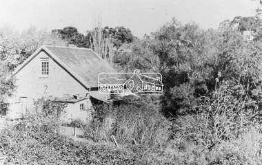
Photograph, Willis Vale on the north bank of the Plenty River, Church Street, Greensborough, c.1950
Photo sourced from Heidelberg Historical Society reproduced on p63 of The Diamond Valley Story by Dianne H. Edwards, Shire of Diamond Valley 1979. "Willis Vale, Greensborough, situated on the north bank of the Plenty River at the end of Church Street. The home wasa built about 1840 by Jame Willis Mayger from bricks hand-made nearby. It was later passed to the Partington family and when this photo was taken the building was deserted. Vandals and finally a bushfire destroyed Willis Vale in the 1950s." Greensborough Historical Society has same image with more accurate information on the date/cause of fire damage https://victoriancollections.net.au/items/585b6c96d0ce2c1268f1c96b "House built by Edward Maygar, Robert Whatmough lived there mid 19th century and later sold to Partington family. It was located on the Plenty River at Partington's Flat Greensborough. The derelict Willis Vale house was destroyed in 1964 when a fire originating from North Plenty Gorge - Kurrak Road - was lit by two teenage boys and made its way several kilometres down to Partington's Flat Greensborough."Black and white copy of photo printed on glossy photographic paper 30.5 x 40.5 cm (12 x 16 inch); image size approx. 18.5 x 28 cmchurch street, diamond valley story, greensborough, james willis mayger, partington family, willis vale -
 Orbost & District Historical Society
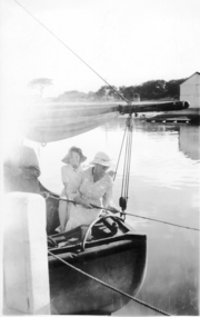
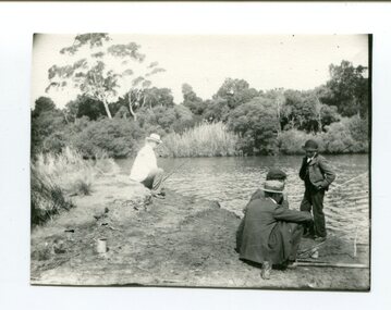
black and white photograph, late 19th - early 20th century?
This photograph shows men fishing in the Snowy River at Marlo - possibly at Bream Point. The man in the white coat is Lancelot Herbert. Lancelot Herbert came to Orbost in 1886, taking up a partnership with local store-owner George Temple. After Mr Temple’s death in 1891, Lancelot took over the store and progressively developed Herberts Snowy River Stores which grew into a department store of several shops along Nicholson St. He also had small shops at Cann River, Noorinbee and Genoa which were run by members of his family, as well as a carrying business and fuel outlets. Lancelot died on 2/6/1911 and his wife Martha [died 1945] are buried in a joint grave in Orbost Cemetery. (info. Noreen and Lindsay Thomson. More from "In Times Gone By' by Deborah Hall)This item is associated with the Herbert family very early settlers in the Orbost district. It is also associated with Marlo which has always been a popular fishing destinationA small black / white photograph of four men fishing from a river bank. Three are sitting and one is standing.on back - Lancelot Herbert in white coat fishingfishing-marlo herbert-lancelot -
Lakes Entrance Historical Society
Postcard - View of Bruthen, W S Vogt Bairnsdale, 1918 c
Black and white postcard showing township, roads and rail, bridges and barked trees with cultivated land beside Tambo River Bruthen VictoriaTambo River at Bruthentownship, bridges, roads and streets -
 Eltham District Historical Society Inc
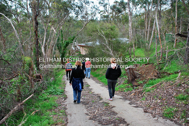
Photograph - Digital Photograph, Jim Connor, River Bend House, 130 Laughing Waters Road, Eltham, 7 September 2013
Laughing Waters Walk, 7 Sep 2013 This Society excursion was a follow up to the Laughing Waters Story told to us by Jane Woollard at our Annual General Meeting in March 2013. It involved a walk commencing from the corner of Laughing Waters and Overbank Roads along Laughing Waters Road to its eastern end and returning partly over the same route - a total distance of about 2.5km. On the way we visited the two artist in residence properties, River Bend and Birrarung, to view the houses on them that are associated with Alistair Knox, Gordon Ford and others in the local mud brick and artistic community. We also able to walk around the derelict ruin which was once home to Gordon and Sue Ford, Boomerang House. An unexpected afternoon tea was offered to us by the artists in residence at Birrarung House and we had a brief opportunity to view inside the house. River Bend was designed and built by Alistair Knox for Rosemary and Bill Cuming in 1968. It sits in a deep cutting on a steep slope above the Yarra River and features floor to ceiling windows and glass doors set into mission brown timber frames and walls of reclaimed bricks in pinkish hue. Rosemary laid the brick paving around the house, a copy of the shell paving found in the ancient French town of Colmar, where the family had lived for a period. The kitchen was equipped with a 1960s stove as well as a cast iron wood stove reclaimed from Rosemary's sister's home in Armadale. Max and Tini Huygens, migrants from Holland, purchased the property in 1975 and named it Tilwinda from an Aboriginal word meaning 'hole in a rock'. In late 1981 Tini died after a short illness, but Max continued to live at Tilwinda until he moved to a retirement village in 2000 and the property was sold to Parks Victoria. Renamed River Bend, the property became part of the Laughing Waters Artist in Residency Program in 2008. Nillumbik Shire Council upgraded the property in 2012 with solar panels, a heat pump for hot water and double glazing to improve the comfort of the artists in residence and make the house more energy efficient. For a more in-depth description of the property and biographies of the various artists in residence commencing from 2008 to 2015, see Jane Woollard's book, "Laughing Waters Road; Art, Landscape & Memory in Eltham" published 2016.2013-09-07, activities, artists in residence, eltham district historical society, heritage excursion, jim connor collection, laughing waters road, river bend house -
 Eltham District Historical Society Inc
Photograph, Looking north across the Fitzsimons Lane Bridge over Yarra River between Eltham and Templestowe, c.1985, 1985c
Turnoff to Candlebark Park on right. The bridge over the Yarra River was initially opened September 22nd, 1961. Newspaper reports at the time of opening stated it linked Bolton Street, Eltham, with Fitzsimons Lane, Templestowe. In 1955 the Country Roads Board (CRB) produced survey plans that showed proposed land acquisition for the future bridge and road approaches. The 1955 plan shows that it was proposed to connect Fitzsimons Lane with Bolton Street in Eltham by a diagonal road across the river. The road connection would then continue along Bolton Street to Main Road. Prior to construction of the bridge the CRB modified the proposal significantly so that there was a new road parallel with Bolton Street and then curving to join Main Road at what was then its intersection with Old Eltham Road. This involved significantly more land acquisition and altered the pattern of land subdivision through this corridor. Initially the new road was just a single two-way carriageway as it would have required a significant widening of the cutting on the Shire of Eltham side of the river. The road was officially un-named but was known locally as the Eltham-Templestowe Road. The 1966 Melway street directory and other 1960s editions also listed the road as the Eltham-Templestowe Road. In December 1970, Eltham Shire Council, in pursuance of the provisions of the Local Government Act, named it Templestowe Road. The road was renamed Fitzsimons Lane around 1984 in conformity with the section south of the river. In 1991 a new bridge was built to the west of the original bridge. Fitzsimons Lane was widened to four traffic lanes although on the Eltham side this was done within the limits of the existing cutting. NEW BRIDGE STARTS THEM EXPLORING Without any fanfares, Country Roads Board workmen on Friday afternoon put the finishing touches to the approaches, removed the barricades, and let the traffic roll over the new Yarra bridge linking Bolton Street, Eltham, with Fitzsimons Lane, Templestowe. Over the week-end many “bridge watchers” who were making one of their periodic inspections of the progress on the new bridge found to their surprise that they could drive over it, so that people who had gone for a run out to Eltham suddenly found themselves wandering through Templestowe and Doncaster. By Monday the word of the bridge’s opening had got around sufficiently for many regular travellers to the city from Eltham and beyond to vary the monotony by going to town via Templestowe and Kew instead of through Heidelberg. They were surprised at the distances – about 3 ½ miles from Eltham to Templestowe, 6 miles from Eltham Shire hall to the Lower Heidelberg Road-Banksia Street intersection. NEW NEIGHBOURS For people on both sides of the river, the new bridge has turned distant friends into near neighbours. A Greensborough man on Sunday took 35 minutes to reach the home of a friend in East Doncaster, but the return trip over the new bridge took only 17 minutes. It will be some time yet before most people work out the possibilities in shorter and quicker trips form the north-eastern areas to the eastern and south-eastern suburbs. The coming of the warmer months will soon teach many, though the short cuts to Peninsular beaches and eastern suburban drive-ins. And before very long it is likely there will be a Tramways bus running from Templestowe to Eltham station. NEW BRIDGE STARTS THEM EXPLORING (1961, September 27). The Diamond Valley News (News clipping held in SEA_74-1_047) The previously un-named road between Main Road and Yarra River, Eltham South, east of Bolton Street was named Templestowe Road, December 15, 1970 NAMING OF STREETS AND ROADS. (1970, December 15). The Diamond Valley News (News clipping held in SEA_74-2_022)Colour photographinfrastructure, shire of eltham infrastructure, bridge, fitzsimons lane bridge, yarra river, candlebark park, red nose day -
 Eltham District Historical Society Inc
Photograph, Fitzsimons Lane Bridge over Yarra River between Eltham and Templestowe
The bridge over the Yarra River was initially opened September 22nd, 1961. Newspaper reports at the time of opening stated it linked Bolton Street, Eltham, with Fitzsimons Lane, Templestowe. In 1955 the Country Roads Board (CRB) produced survey plans that showed proposed land acquisition for the future bridge and road approaches. The 1955 plan shows that it was proposed to connect Fitzsimons Lane with Bolton Street in Eltham by a diagonal road across the river. The road connection would then continue along Bolton Street to Main Road. Prior to construction of the bridge the CRB modified the proposal significantly so that there was a new road parallel with Bolton Street and then curving to join Main Road at what was then its intersection with Old Eltham Road. This involved significantly more land acquisition and altered the pattern of land subdivision through this corridor. Initially the new road was just a single two-way carriageway as it would have required a significant widening of the cutting on the Shire of Eltham side of the river. The road was officially un-named but was known locally as the Eltham-Templestowe Road. The 1966 Melway street directory and other 1960s editions also listed the road as the Eltham-Templestowe Road. In December 1970, Eltham Shire Council, in pursuance of the provisions of the Local Government Act, named it Templestowe Road. The road was renamed Fitzsimons Lane around 1984 in conformity with the section south of the river. In 1991 a new bridge was built to the west of the original bridge. Fitzsimons Lane was widened to four traffic lanes although on the Eltham side this was done within the limits of the existing cutting. NEW BRIDGE STARTS THEM EXPLORING Without any fanfares, Country Roads Board workmen on Friday afternoon put the finishing touches to the approaches, removed the barricades, and let the traffic roll over the new Yarra bridge linking Bolton Street, Eltham, with Fitzsimons Lane, Templestowe. Over the week-end many “bridge watchers” who were making one of their periodic inspections of the progress on the new bridge found to their surprise that they could drive over it, so that people who had gone for a run out to Eltham suddenly found themselves wandering through Templestowe and Doncaster. By Monday the word of the bridge’s opening had got around sufficiently for many regular travellers to the city from Eltham and beyond to vary the monotony by going to town via Templestowe and Kew instead of through Heidelberg. They were surprised at the distances – about 3 ½ miles from Eltham to Templestowe, 6 miles from Eltham Shire hall to the Lower Heidelberg Road-Banksia Street intersection. NEW NEIGHBOURS For people on both sides of the river, the new bridge has turned distant friends into near neighbours. A Greensborough man on Sunday took 35 minutes to reach the home of a friend in East Doncaster, but the return trip over the new bridge took only 17 minutes. It will be some time yet before most people work out the possibilities in shorter and quicker trips form the north-eastern areas to the eastern and south-eastern suburbs. The coming of the warmer months will soon teach many, though the short cuts to Peninsular beaches and eastern suburban drive-ins. And before very long it is likely there will be a Tramways bus running from Templestowe to Eltham station. NEW BRIDGE STARTS THEM EXPLORING (1961, September 27). The Diamond Valley News (News clipping held in SEA_74-1_047) The previously un-named road between Main Road and Yarra River, Eltham South, east of Bolton Street was named Templestowe Road, December 15, 1970 NAMING OF STREETS AND ROADS. (1970, December 15). The Diamond Valley News (News clipping held in SEA_74-2_022)Black and white photographinfrastructure, shire of eltham infrastructure, bridge, fitzsimons lane bridge, yarra river