Showing 123778 items matching "main-road"
-
 Halls Gap & Grampians Historical Society
Photograph - B/W, Oct-86
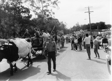
The bullock team was part of a parade held on the main street of Halls Gap in conjunction with the 150th anniversary of Major Mitchell's visit to the area. There was also a plaque unveiled in commemoration of the Wildflower Show and its many volunteers.The photo shows a crowd watching a bullock team hauling a dray with five children sitting in it down a road. The bullock driver is walking alongside holding a long handled whip over his shoulder. A wagon pulled by draught horses can be seen behind the bullock dray. Buildings can be seen to the right rear of the photo and trees line the left side of the street.events, parades -
 Melbourne Tram Museum
Slide - Black and white reproduction photograph - K class tram 92, mid 1920s
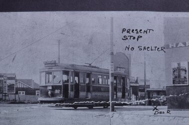
Photograph - of a K class four-wheel or single truck tram on a PMTT route 14 (STRATHALBYN ST (Kew) - VICTORIA BRIDGE) tram service, at Harp Road and High St. The reference gives the tram based at Kew Depot in 1928. The tram was originally a Prahran and Malvern Tramways Trust tram, though, by the time of this photograph, it has been re-lettered for the MMTB, which took over the PMTT in 1920. The photograph has been marked up for a submission possibly to either Council or the MMTB for a waiting room or shelter at this location. The wall of the Harp of Erin Hotel and a Victoria Bitter sign can be seen on the right-hand side. The original photo appears to have been torn. Original photo mid to late 1920's.Yields information about the K class tram of the MMTB and methods of seeking a tram stop shelter and High Street and Harp Road intersection.Kodachrome cardboard duplicate slide - Black and white reproduction photograph - K class tram 92 - at Harp Road Kew "MP17" in penciltrams, tramways, kew, harp road, route 14, k class tram, tram 92, harp of erin, victoria bitter, high st, strathalbyn st -
 Mission to Seafarers Victoria
Photograph - Photograph, Black and white, Bill Doyle (Reverend C.J. Eldridge-Doyle), c. 1950
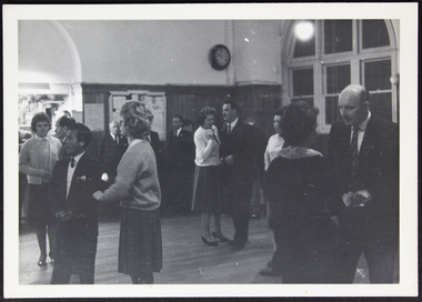
The photograph portrays the main hall of the Mission to Seamen as it was used c.1950.The photograph is documents a moment in history that reflects how the main hall of the Mission to Seamen was used around the 1950s. The photograph also portrays one of many events held by the Ladies Harbour Lights Guild as one of the services provided for visiting seafarers.A black and white photograph inside the Mission to Seafarers Melbourne main hall. In the foreground there are two couples; on the left side of the photograph the couple are facing the left side, a man in a suit, vest and tie and a lady to the right in a mid-length skirt, jumper and short hair. The couple on the right of the photograph are facing each other - the lady has her back to the camera, and the man facing more toward the camera, he is also in a suit and is balding. A couple are standing in the mid ground, central in the photograph; a lady is on the left in a light coloured cardigan, mid length skirt and short dark hair; the man on the right is wearing a dark suit and tie, and a light coloured shirt. There are a number of people in the background that are partly concealed by the couples in the mid-foreground. An archway is visible to the left, that leads to the 'cafeteria', and an arch window can be seen on the right side of the photograph in the background, The hardwood floorboards are visible, as is the wainscote (wood panelling) on the walls in the background. A clock is situated right of centre on the back wall.collar, clock, vest, window, suit, 1950s, main-hall, tie, wainscote, cardigan, jumper, skirt, arch, bald, lhlg, dance, socialising, events, entertainments, mission to seafarers, mission to seamen, seamen mission, flinders street, ladies harbour lights guild, hardwood, floorboards, wood panelling -
 Melbourne Tram Museum
Slide - Set of 2, Keith Kings, 23/03/1968 12:00:00 AM
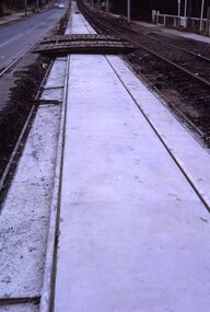
35mm Kodak white cardboard colour slide by Keith Kings of 23/3/68 and 6/4/68. .1 - Glenferrie Road Kooyong track renewal showing the first section of completed track. Shows two road crossovers. .2 - ditto, showing one end of the new crossover with temporary track on the right. See Keith's slide notes.Keith Kings stamp and number "20-19" and "20-32", with details of exposure. 23/3/68 and 6/4/68. .1 - "New concrete trackwork in Glenferrie Rd north from Kooyong railway Xing ready to be brought into use. Temporary track still in use at right" .2 - "New design for xover in Glenferrie Rd, near cnr Gardiner Rd Kooyong, Removable sections form the road surface and facilitate maintenance and renewal."trams, tramways, glenferrie road, trackwork, temporary track, kooyong -
 Hume City Civic Collection
Photograph, Early 1970s
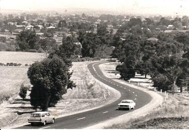
In the early 1970s the eastern approach to Sunbury was changed. The stone bridge spanning the Jacksons Creek was replaced by a wider concrete structure and dangerous curves were taken out of the road. The area on the LHS of the photograph including the two arched stone bridge has been incorporated into a public picnic area.A black and white panoramic view of the eastern approach to Sunbury and the Sunbury township before the road was widened and straightened and the new bridge was built. There are two cars in the foreground. One is approaching the bridge and the other is leaving Sunbury.macedon street, macedon street road bridge, jacksons creek, sunbury township, george evans collection -
 Eltham District Historical Society Inc
Photograph, Roll of Honour Board, Eltham War Memorial, 2005
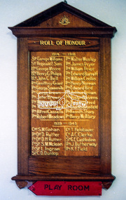
This 1954 Roll of Honour board was an action of the WW2 Eltham War memorial Trust, for hanging in their Child Welfare Centre building on their property in Main Road, Eltham. The Johnstons Furniture Production Company made up the board and had the names of the local Eltham enlistees applied in gold lettering at a total cost of £13.10.00. The names were copied by the Eltham RSL from the obelisk which was first erected by the WW1 Eltham Peace Celebrations in August 1919 at the northwest corner of Bridge Street and Main Road. During road widening plans by the Council, the obelisk was moved to the garden area of the refurbished RSL branch building in Main Road for safekeeping. The Honour Roll Board was sent to the Eltham RSL sub-branch around 1999. Following the merger of the Eltham and Montmorency sub-branches and sale of the Eltham property, the obelisk was relocated to a location in front of the Eltham War Memorial. The Honour Roll Board was retrieved by former Eltham District Historical Society President, Harry Gilham in September 2004 who arranged for it to be hung in the Eltham War Memorial Hall (former Children's Library). It is attached to the brick wall face of the west (rear) wall of the Hall.Colour photo print and 18 photocopied and hand written mixed media pages1953, briar hill timber, cr. e.j. andrew, eltham rsl sub-branch, eltham war memorial, eltham war memorial hall, eltham war memorial trust, ernie andrew, harry gilham collection, honour roll, johnstons furniture production company, johnstons furniture productions, meeting minutes, minute book, montmorency-eltham rsl sub-branch, nillumbik shire council, roll of honour, stanley s addison collection, stanley simpson addison -
 Falls Creek Historical Society
Poster - Kangaroo Hoppet 1995
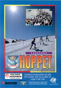
The Kangaroo Hoppet is Australia’s premier long distance cross country ski race, and a member of the Worldloppet series of international cross country ski events. The first race at Falls Creek was held in 1979 under the name of “Australian Birkebeiner”. It was a 21km race with about 80 participants organised by the Birkebeiner Nordic Ski Club of Mount Beauty. The course started and finished at Falls Creek Alpine Resort and took participants out into the Bogong High Plains. After running the event for 10 years, it was decided they should become part of the Worldloppet series of marathon ski races. Representatives from the Birkebeiner Nordic Ski Club and the Australian Ski Federation attended the Worldloppet Annual Meeting in Finland in June 1990 to put the case for the acceptance of an Australian event into the Worldloppet series. Before being admitted, they had to demonstrate that the Birkebeiner Club could run a world class event, so three months later in August 1990 a 42km event named the Australian International Ski Marathon was held at Falls Creek together with a 21km Birkebeiner race and a 7km event called the Birkebeiner Lite. The event was approved by delegates from USA, Norway and Austria, in 1991 Australia became the 12th member of Worldloppet, with the condition that there had to be a name change. After some late night discussion allegedly involving red wine from North East Victoria the main event became the 42km Kangaroo Hoppet, with the minor events being the 21km Australian Birkebeiner, and 7km Joey Hoppet. In the winter of 1991, the first Kangaroo Hoppet was held. It was a great success and has been a regular fixture on the international ski calendar ever since. It features the main 42km event as well as a 21km event and a 7km event. The Hoppet brings the Australian snowfields to an international audience. In 1995 the Men's Winner was Andre Jungen from Switzerland in a time of 2:22:57. The winner of the Women's event was Maria Theurl of Austria in a time of 2:56:08.This poster is significant because it documents an event which brings international attention to Falls Creek and the surrounding region.A large coloured poster a main image of skiers ascending a slope. A smaller inset image features a large group of skiers. A title is written at the bottom of the image in graduated orange letters. The logos of Worldloppet, Southern Hydro, Holden, QANTAS and the Birkebeiner Nordic Ski Club are across the bottom.Beneath image: AUSTRALIA'S WORLDLOPPET SKI RACE/ 26TH AUGUST 1995, FALLS CREEK, VIC . 42 KM .21KM. 7KM. Phone: (057) 54 3103 Fax: (057) 54 4475 P.O. Box 400 Mt. Beauty 3699 Australia In Border around photos: Photographs: Glen Tempest - Open Spaces Photographykangaroo hoppet, worldloppet events, falls creek, mt. beauty -
 Halls Gap & Grampians Historical Society
Photograph - B/W, C 1900
In early 1900, three Emmett brothers, with support from George Mason, set about following up a report of gold in the area. Confirmation of gold led to a gold rush in June 1900. Traffic from Ararat and Willaura passed Mason's Farm and it was on Mason's land that the first settlement, Ladysmith, sprang up.Road leading to Mt William goldfield 1900. George Mason's farmhouse on right hand side of road.access routes, roads, mining, ladysmith -
 Whitehorse Historical Society Inc.
Document, 1924 Tunstall Properties, 11/02/1924 12:00:00 AM
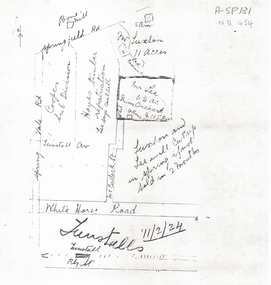
Hand drawn plans of properties bordered by Tunstall (Nunawading) Railway Station,Hand drawn plans of properties bordered by Tunstall (Nunawading) Railway Station, Springvale Road and Springfield Road.Hand drawn plans of properties bordered by Tunstall (Nunawading) Railway Station, plans, whitehorse road, nunawading, tunstall railway station, tunstall avenue, springvale road, springfield road, luxton, lee, mcculloch street, hayes timber, cooper, land subdivision -
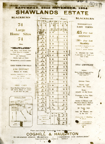 Whitehorse Historical Society Inc.
Document, Shawlands Estate, 22/11/1924 12:00:00 AM
Notice of Sale of land Holland Road and Canterbury RoadNotice of Sale of land Holland Road and Canterbury Road Blackburn Original in Haughton Maps LaTrobe LibraryNotice of Sale of land Holland Road and Canterbury Road land subdivision, canterbury road, blackburn south, holland road, shawlands avenue, coghill & haughton, shawlands estate, haughton map collection, state library of victoria. latrobe library -
 Whitehorse Historical Society Inc.
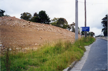
Photograph, Bridgeworks - Mitcham
Coloured photograph of earthworks on side of road during bridge construction along Deep Creek Road, Mitchamdeep creek road, mitcham -
 Whitehorse Historical Society Inc.
Photograph, Mitcham Methodist Church
Mitcham Methodist Church. Now 339 Mitcham Road - Roads Service Station. Cross Ref: ND1837.methodist church mitcham, glasson, bill -
 Whitehorse Historical Society Inc.
Photograph, Adult Deaf & Dumb Home, Blackburn, C.1970
B/W photo of view from road of Adult Deaf & Dumb Home, Central Road, Blackburnadult deaf & dumb home, blackburn -
 Whitehorse Historical Society Inc.
Photograph, Blackburn roundabout, 2012
Coloured photograph of the Blackburn roundabout with Blackburn Road coming in from the right to join Railway Road - 2012blackburn road, blackburn, railway road, blackburn roundabout, shops, shopping -
 Whitehorse Historical Society Inc.
Photograph, A. C. Brown Stores, c. 1918
Used by Robin Da Costa in 'Blackburn - a picturesque history'Black & white photo of A. C. Brown Stores - south east cnr Railway Road & Blackburn Roadrailway road blackburn, blackburn road blackburn, a. c. brown stores -
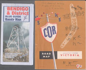 Bendigo Historical Society Inc.
Map - Road maps
BHS CollectionTwo road maps. On, Bendigo & District blue guide handy map the other a road map of Victoria. On the back of the Bendigo map the date October 2000. On the Victoria map the words in pen "This doesn't belong to you, it is mine". L.J. Ellison and a blue stamp of Axedale service station. Aileen and John Ellison Collection.road map, victoria, bendigo -
 Canterbury History Group
Photograph - Lawson Bros. Grocers Pty Ltd, 1935
Interior view of a Lawson Bros grocers shop, either Highfield Road or Maling Road Canterbury c1935.canterbury, lawson bros.> grocers pty ltd, grocers, food -
Canterbury History Group
Photograph - Prospect Hill Road, Canterbury, 1920c
Black and white photograph of Prospect Hill Road Canterbury, near Maling Road, looking west, 1920ccanterbury, prospect hill road, roads and streets, houses -
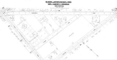 Camberwell Historical Society
Map (Item) - MMBW map, Melbourne and Metropolitan Board of Works, Melbourne and Metropolitan Board of Works - Shire of Boroondara and Camberwell - Detail Plan no. 1852, August 1904
Lithographer L.E, exd W.A.L., August 1904, no. 95. 40P. 15Wmelbourne and metropolitan board of works, map, camberwell, cartography -
Canterbury History Group
Photograph - Photograph of the bronze plaque for the Canterbury Road and Maling Road junction, Jan Pigot, 2004
Coloured photograph of the bronze plaque for the Canterbury Road and Maling Road junction. There are 2 copies of this photograph in the pocket.canterbury, maling road, shops, signs, plaques -
Canterbury History Group
Photograph - Two assistants serving behind the counter at No. 88 maling Road, Jan Pigot, 27/03/1993 12:00:00 AM
Coloured photograph of two assistants serving behind the counter of the Maling Road Patisserie at No. 88 Maling Road.canterbury, maling road, shops, foods -
Canterbury History Group
Photograph - Outside view of shop on the corner of Maling Road and Theatre Place at No. 109 Maling Road, Jan Pigot, 27/03/1993 12:00:00 AM
Coloured photograph of the outside view of shop on the corner of Maling Road and Theatre Place at No. 109 Maling Roadcanterbury, maling road, shops -
Canterbury History Group
Photograph - Street view of shop at No. 94 Maling Road, Jan Pigot, 1994
Coloured photograph of the street view of the Pharmacy on the corner of Maling Road and Bryson Street at No. 94 Maling Roadcanterbury, maling road, shops, signs -
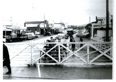 Wodonga & District Historical Society Inc
Photograph - High Street, Wodonga Level Crossing, 1954
This image is representative of many photographs illustrating the level crossing in the centre of Wodonga. Since its opening in 1873 the railway line had crossed High Street, originally called Sydney Road. It bisected the city with level crossing gates frequently stopping the flow of traffic and pedestrians as trains passed through. Signal Box B stood on the eastern side of the High Street level crossing and a big wheel closed and opened the gates. On 17th September, 1961, it was replaced by boom gates and flashing lights. The railway crossing was removed from High Street as part of the Wodonga Rail Bypass project. This involved a 5.5 kilometres bypass, the elimination of 11 level crossings and the relocation of the Wodonga station. It was moved from its original central location to a position on a new line on the northern edge of the town. The old station closed on 8 November 2008 and the new station opened on 25 June 2011.This image has local and statewide significance as it captures the former crossing in a major railway system. The railways played a critical role in opening up Victoria and connecting Australia for trade, business, social communication and transport.A black and white photo of the railway level crossing in High Street, Wodonga with gates closed. The Melbourne to Sydney railway line went through the centre of Wodonga and trains frequently held up internal vehicular and pedestrian traffic in the main street. railways wodonga, wodonga railway relocation, high st wodonga rail crossing -
 City of Kingston
Pamphlet - Colour, H. R. Hill & Co, Walker's Estate, Cheltenham for sale by public auction, c. 1923
Sales plan for land in the suburb of Cheltenham, encompassing both sides of Walker Grove, a section of Centre Dandenong Rd and Axelton St. The developing urban area of Cheltenham within the City of Kingston. This land sale pamphlet illustrates the subdivision of land within the municipality and the changing demographic of the district as new houses are constructed.Black and white pamphlet advertising for private sale the Station Entrance Estate, Highett. Incorporates a map of the estate bordered by Wickham Road, Railway Parade, Highett Road and Point Nepean Road.Handwritten in black pen on subdivision map: 'x' written on subdivisions 2, 3, 8-11, 15-17, 19. Potentially indicating that these properties did not sell at auction. Handwritten in black pen on subdivision map: assumed sale price on subdivisions 1, 4-7, 12-14, 18, 20-31. land sales, cheltenham, estate -
Canterbury History Group
Photograph - Exposed side door of shop No. 80 Maling Road, Jan Pigot, 27/03/1993 12:00:00 AM
Coloured photograph of the exposed side door of shop No. 80 Maling Road due to the demolition of the Maling Road Theatre. Sign showing the land for lease and a profile of shop No. 80 Maling Roadcanterbury, maling road, shops -
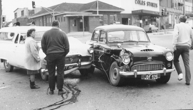 Ringwood and District Historical Society
Photograph, 2 car Accident in front of Ringwood Post Office, cnr Whitehorse Rd and Ringwood St circa 1960s
Catalogue card reads, "Accident on Whitehorse Road. Old Ringwood Post Office on corner of Ringwood St. and Whitehorse Road." -
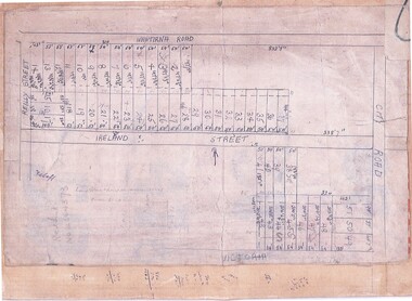 Ringwood and District Historical Society
Document, Subdivision Map (Undated) - Ringwood, Victoria
Hand-drawn copy of subdivision plan showing numbered residential allotments with property dimensions.Map includes Wantirna Road, Ireland Street, City Road and Victoria Street (later Regina Street), Ringwood, Victoria. -
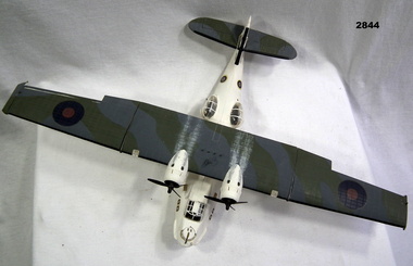 Bendigo Military Museum
Leisure object - MODEL, FLYING BOAT, post WW2
Plastic scale model of Catalina Flying Boat. Twin engines on high main wing. Camouflage colouring on top of wing & tail wings. White fuselage & under wings. Gun mounted in front of cockpit. Two Rockets under each side of main wing. Gun turrets on each side of fuselage.Each side of fuselage under cockpit: "No 88" Each side of tail fin: "No 1188"military history - souvenirs - air force, passchendaele barracks trust -
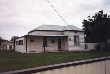 Lakes Entrance Historical Society
Photograph - Historic House, 2000
Owner Keith Bryce? Let as holiday accommodation.|Also one other colour photograph similar view, taken from street shows house behind solid fence, tall trees at side.Colour photograph of a timber dwelling at 40 Roadknight Street, with corrugated iron hipped roof. Three entries from front veranda, one to enclosed side veranda, a main entry, and third into extension beside main entry. Mix of door and window styles reflects DIY additions. Lakes Entrance Victoriahouses, heritage study