Showing 2075 items
matching parish
-
 Christ Church Anglican Parish of Warrnambool
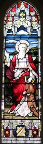
Memorial window: Rev Andrew PEACOCK, "I will make you fishers of men"
Stained glass window, south wall, main nave (adjacent to the pulpit). The window is a pictorial representation of St Andrew who live to old age. There is a tradition that on being sentenced to death, he requested that he be crucified on a saltire (diagonal cross, see base of window) as he felt unworthy to be crucified on the vertical cross of Christ. Another symbol of association with St Andrew is the fishing net.The Rev. Andrew Peacock, Archdeacon of the Otways, was the fourth Vicar (1906-1912) of the Parish of Warrnambool. He was highly regarded throughout the community and died following a very short illness. His brother, Sir Alexander Peacock, three times premier of Victoria, officially unveiled a tablet on the north-west corner of the Parish Hall complex on Saturday 25th April and attended the dedication of the memorial window on Sunday 26th April 1913. Rev AE Peacock is buried at Creswick cemetery, Victoria. -
 Ringwood and District Historical Society
Envelope, Packet 3 St Paul's Anglican Church, Ringwood, Circa 1920s-1990s
Various newsletters and local church records circa 1920s-1990s as follows: 4940-01 Parish Messenger – Easter 1927 4940-02 Parish Messenger – April, No.42 4940-03 Anglican News – November, No.15 4940-04 Parish Paper – April 1937 4940-05 Parish News Supplements – June 1969, August 1969, September 1969, April 1977 4940-06 List of Memorials in St. Paul’s Ringwood - 1971 4940-07 Civic Service, 30th Anniversary City of Ringwood – June 1990 4940-08 Opening and dedication of “Glamorgan Court” - 1989 4940-09 Civic Service Commemorating Proclamation of City of Ringwood – 20th March 1960 4940-10 Institution and Induction of The Reverend Douglas G. Edmonds - 12th December 1989 4940-11 Last Service at St Paul’s in Ringwood Street – 28th May 1967 4940-12 Catalogue, Art Exhibition – March/April 1979 4940-13 (duplicate entry deleted) 4940-14 Parish News “Spiritus Gladius” Centenary Celebration - 1979 4940-15 St.Paul’s Centenary Worship – 14th October 1979 4940-16 Service/Newsletter pamphlets - January to April 1996 (incomplete collection) 4940-17 Advertisement for New Theatre "Polling Day" concert at church hall (near Post Office) - 1961 4940-18 Commissioning of Penny Charters, Janice Dear, and David Jones as students in ministry 4940-19 Funeral Service for late Floss Davidson (Ms. V. Boulter) 19 January 1979 4940-20 Service of Thanksgiving for Rev. John & Mrs. Helen Howells - 18 June 1989 4940-21 Bush Church Aid 70th Anniversary, St Paul's Ringwood - 1 October 1989 4940-22 Parish Baptism, Confirmation and Eucharist - 12 November 1989 -
Bendigo Historical Society Inc.
Map - RAYWOOD GOLD FIELD MAP, 1902
Map. Raywood Gold Field Map. Linen backed map of Raywood and Neilborough Township and surrounds showing the location of varying underground workings. Surveyed by H S Whitelaw 1/6/02. It shows underground workings from The Perseverance Party and moreshed and Party and underground workings on the Old Pioneer Reef. Mentions the Parish of Yallook, Parish of Neilborough, Yarraberb, Mushroom Flat, Murray Valley Plain, Eaglehawk and Kerang Railway, Green Hill, Doughboy, Redmond's Gully, Pickpocket Lead, Raywood Lead, Inglewood Lead, Shaw's Road, Nuggety Shaft, Barkly Shaft, Maori Bendmap, gold field map, raywood gold field map, neilborough, h s whitelaw, geological survey of victoria bulletin no 12 plate 11 -
 City of Moorabbin Historical Society (Operating the Box Cottage Museum)
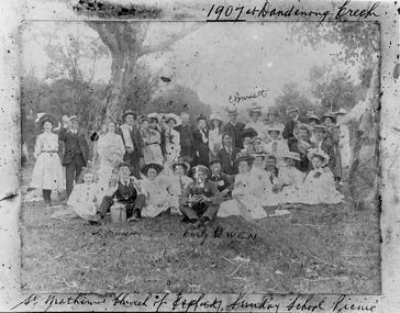
Photograph - St Matthew's Church of England Sunday School Picnic 1907, 1907
The Anglican Cheltenham parish was created in 1865 by excising a portion of the parish of St Andrews Brighton. A small brick church was completed in 1867 to serve a rural community stretching from Brighton South (Moorabbin) to Mordialloc. 1867 St Matthew's Church of England was erected in Cheltenham beside the Nepean Highway near Charman Road. The early settlers established a tennis club, cricket team and social groups. A typical social event was the annual Sunday School Picnic held in 1907 at Dandenong Creek.Young members are mentioned Curly Owen,C,Burnett,A Manett St Matthew's Church of England Cheltenham was erected in 1867 and was integral to the spiritual well being and social life of the early settlers.Black & White photograph of the St Matthew's Church of England Sunday School Picnic 1907Handwritten Curly Owen, C, Burnett, A Manett st. matthew's church of england cheltenham, sunday school picnics, anglican church, st andrew's church brighton, owen curly, burnett c . manett a, horse drawn carts, toll gates brighton, motor cars 1900, steam engines, early settlers, bentleigh, parish of moorabbin, city of moorabbin, county of bourke, moorabbin roads board, shire of moorabbin, henry dendy's special survey 1841, were j.b., bent thomas, o'shannassy john, king richard, charman stephen, highett william, ormond francis, maynard dennis, market gardeners, vineyards, orchards -
Ringwood and District Historical Society
Legal record - Conditions of Sale (C.E. Carter), Ringwood Electric Railway Estate, Lots 98 and 99, Sale to Tilbury and Albon, 1925
Original Particulars and Conditions of Sale document by C.E. Carter & F. H. Patterson & Co, to B.C. Tilbury Esq and A.J.Albon Esq: Lots 98 and 99, Electric Railway estate, Ringwood Plan of Subdivision 9473, Crown Portion 18, Parish of Ringwood. -
 Federation University Historical Collection
Letter, Grant Street Terraces, 1992
.1) 5 pages of correspondence relating to a request for survey of Crown Allotment 11, Section 11, Parish of Cardigan (included plan) .2) 3 pages relating to a tender for Bluestone / drystone terraces along the Grant Street frontage of the Ballarat School of Minesballarat school of mines, grant street, gillies street, j. winter, e.a. wynne, w.b. ochiltree, ballarat industrial school, prince of wales park, ballarat golf club -
Bendigo Historical Society Inc.
Map - CAMPBELL COLLECTION: BENDIGO AND DISTRICT MAPS, 8-2-29
Map. Bagshot, Parishes of Wellsford, Ellesmere, and Bagshot. Huntly 4 miles, Fosterville 3 miles. Total area 5037 acres, Prepared in W.P.B. from A.C.L and D.B. Plans, by W.J.Galbraith 8-2-29. (number 382 in map cupboard 1).W.J.Galbraithmap, bendigo, agricultural lands -
Bendigo Historical Society Inc.
Map - CAMPBELL COLLECTION: BENDIGO AND DISTRICT MAPS, 30-1-29
Map. Ellesmere, Parish of Ellesmere, scale 20 chains to 1 inch. Total area 3926 acres. Prepared in W.P.B. from A. and P. Plans, by W.J. Galbraith, 30-1-29, to Bendigo along Fosterville. (number 381 in map cupboard 1)W.J.Galbraithmap, bendigo, agricultural lands -
Bendigo Historical Society Inc.
Map - CAMPBELL COLLECTION: BENDIGO AND DISTRICT MAPS, 16-5-29
Map. Egerton, Parishes of Egerton and Whirrakee. Scale 20 chains to 1 inch. Total area 5401 acres. Prepared in W.P.B. from A. and C.L. Plans by W.J.G. 16-5-29. To Rochester 12 miles. (number 366 in map cupboard 1)W.J.G.(W.J.Galbraith)map, bendigo, allotments -
Bendigo Historical Society Inc.
Map - CAMPBELL COLLECTION: BENDIGO AND DISTRICT MAPS, 8-2-29
Map. Bagshot, Parishes of Wellsford, Ellesmere and Bagshot. Scale 20 chains to 1 inch. Total area 5037 acres. Prepared in W.P.B. from A.C.l. and D.B. Plans, W.J. Galbraith, 8-2-29 (number 353 in map cupboard 1)W.J.Galbraithmap, bendigo, agricultural lands -
Bendigo Historical Society Inc.
Map - CAMPBELL COLLECTION: BENDIGO AND DISTRICT MAPS, 12-2-29
Map. Axedale, Parishes of Ellesmere and Axedale. Scale 20 chains to 1 inch. To the west is Wellsford. Total area 4156 acres. Prepared in W.P.B. from A and P plans by W.J. Galbraith 12-2-29. (number 352 in map cupboard 1)W.J.Galbraithmap, bendigo, agricultural lands -
Bendigo Historical Society Inc.
Map - CAMPBELL COLLECTION: BENDIGO AND DISTRICT MAPS
Map. Longlea, Parishes of Eppalock and Axedale. Scale 20 chains to 1 inch. Total area of map 2372 acres, with Bendigo 9 1/2 miles away. H.A. Darby 18-6-29. (number 349 in map cupboard 1)H.A Darbymap, bendigo, allotments -
 Bendigo Historical Society Inc.
Document - RAVENSWOOD - CROWN LAND - FORMER WATER RESERVE, 20 March 2012
Document, Ravenswood Crown Land, Former Water Reserve, Parish of Ravenswood, Comprises 3 old granite buildings related to the Ravenswood Run. Old dam,and granite wall, potential archaeological values. Ironbark Forests & Woodlands investigation as natural features Reserve.DSR (Norn Stimson)document, ravenswood crown land -
Bendigo Historical Society Inc.
Book - THE FIRST HUNDRED YEARS, 1968
The First Hundred Years , history of the parish church of St. Paul, Bendigo, Victoria 1868-1968. A record of vision and courage. 40 pages, with photoraphs, illustrations. Name written on front page Harold Curnow 31.1.68 Index included compiled by Estelle Hewsonbendigo, churches, st. paul's, bendigo, church, centenary, st. paul's bendigo, religion -
 Bendigo Historical Society Inc.
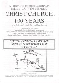
Document - CHURCHES OF BENDIGO COLLECTION: CHRIST CHURCH 100 YEARS
Eleven pages document titled: Anglican Church of Australia Parish-South east Bendigo. Christ Church 100 years (cnr Strickland road, Barr and Fox Streets) Special centenary service Sunday 21 September 1997 at 10-30 am.church, church of christ, centenary -
 Bendigo Historical Society Inc.
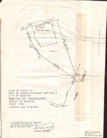
Document - CROWN ALLOTMENT 406A (PLAN) JOSS HOUSE
Plan of Survey of part of Crown Allotment 406A Sec E. City of Bendigo. Parish of Sandhurst. County of Bendigo. Scale 1:500. (Copy of Original). As at 21 February 1979. This survey shows the location of the Joss House and the portion of land where it is located.plan, bendigo, joss house, crown allotment 406a (plan), joss house -
 Bendigo Historical Society Inc.
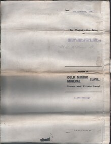
Document - MCCOLL, RANKIN AND STANISTREET COLLECTION: CENTRAL NELL GWYNNE, 5/10/1941
Document. Paper Document containing an indenture detailing lease between His Majesty the King to Central Nell Gwynne Gold Mining Company No Liability. Included is a map of the mining district of Bendigo Parish of Sandhurst. No 11172 Bendigo Vol 327 Fol 36016.McColl, Rankin & Stanistreetorganization, business, central nell gwynne, mccoll, rankin & stanistreet, central nell gwynne, gold mining, lease -
 Mt Dandenong & District Historical Society Inc.
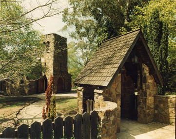
Photograph, St. Michael and All Angels Anglican Church c1970, c1970
St Michael and All Angels Anglican Church in the Parish of Mt Dandenong sited on the corner of Falls Road and the Mt Dandenong Tourist Road, Kalorama. The church was built in 1940. For further information see 'A Light In The Hills', 2 editions by Henry L. Speagle.falls road, mt. dandenong tourist road, st. michael's church, st. michael and all angels anglican church, anglican church, henry l. speagle -
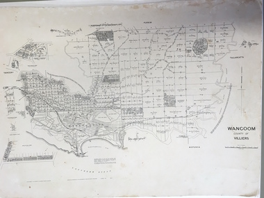 Warrnambool and District Historical Society Inc.
Document: Map, Map Wangoom County of Villiers, 1955
This map contains the names, acreage details and dates of the original property owners of the Parish of Wangoom (County of Villiers), excluding the township of Warrnambool. It also has details of the Crown Lands adjoining the Merri and Hopkins Rivers. This is a most important map as it has details on the original property owners. It is a most valuable research tool and is one of our most-used maps.This is a map, printed in black and white and mounted on cardboard. Where there was intensive land ownership the details have been reproduced in larger print on the margins of the map. There are scuff and dirt marks on the map but it is otherwise in good condition.‘Wangoom, County of Villiers’wangoom, warrnambool, county of villiers -
Glen Eira Historical Society
Document - St Mary The Virgin, Kooyong Road, South Caulfield
Handwritten document on Parish of St Mary the Virgin noting that the church has been situated at a number of venues. The present address has been used by St Mary's for twelve years; and the Father is Graeme A. Mitchellst mary the virgin, kooyong road, caulfield south, mitchell a. graeme -
 St Kilda Historical Society
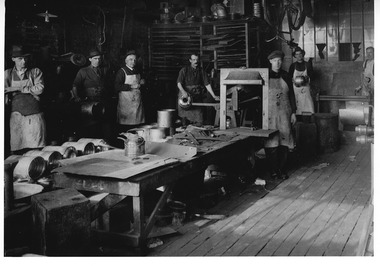
Photograph - Photograph industrial, Barge, Galliers and Klaer Iron and Brass Foundry, 1925
Interior view of coppershop Armstrong, Bates, Bernidis, Booth, Burgess, Daiey, Elligham, Featherson, Fulton, Hannan, Kelly, Linard, Mahony, Mathews, Melbourne, Osborne, Parish, Peel, Perkins, Schelble, Walker, West, black and white photograph original good condition -
Glen Eira Historical Society
Article - Holy Cross Church, Glen Huntly Road, 705, Caulfield South
Two Holy Cross Musical Society Programs. Undated. Patience or Bunthorne’s Bride and The Mikado Article from Caulfield/ Port Phillip Leader 09/08/2011 Parish to Share Load Colour photo with article.holy cross church, freese christina, caulfield south, glen huntly road, rosenberger virginia, catholic church, programs, mckenny ross fr., holy cross advisory committee, southwick david mp lane colin -
 Greensborough Historical Society
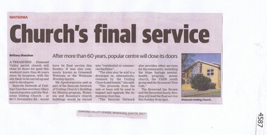
Newspaper Clipping, Diamond Valley Leader, Church’s final service, 14/06/2017
A treasured Diamond Valley parish church in Devonshire Road Watsonia will close its doors for good this weekend more than 60 years since its inception, with the site likely to be carved up and sold to developers.News article 1 page, black text, colour image.watsonia uniting church, devonshire road, gresswell watsonia -
 Whittlesea Historical Society Inc.
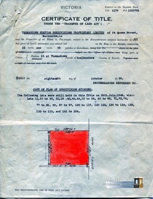
Document - Certificate of Title, Certificate of Title, Vol. 5179 Fol. 1035791, 18 Oct 1926
Title in the name of Thomastown Station Subdivisions Propriety Limited of 94 Queen Street, Melbourne, 32 acres being part of Portion 25 at Thomastown, Parish of Keelbundora County of Bourke, dated 18th October 1926.1 p. coloursubdivision, thomastown, thomastown station subdivisions, epping road, main street thomastown, portion 25 thomastown -
 Bendigo Historical Society Inc.
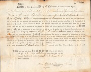
Document - BROCKLEY FAMILY DOCUMENTS: PERMISSION TO MARRY WITHOUT BANNS
Certificate No. 3522 permission to marry without the publication of Banns. The permission is for Mr Samual Brockley and Miss Annie Bowman, both of Sandhurst. Dated 13 February 1877. Parish of St. Pauls Sandhurst. Document has imprint on the bottom right corner. Also a photocopy.document, certificate, marriage, permission to marry without banns, parish of st pauls sandhurst, mr samual brockley, miss annie bowman -
 Bendigo Historical Society Inc.
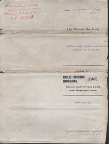
Document - MCCOLL, RANKIN AND STANISTREET COLLECTION: CENTRAL NELL GWYNNE - FORM D GOLD MINING LEASE 10981 BENDIGO, 5 Oct 1936
Document. Renewal New Lease no 11073 His Majesty the King to Central Nell Gwynne GMC N/L. 1 map no 10981 of Mining District of Bendigo Parish of Sandhurst City of Bendigo County of Bendigo. No 10981 Bendigo Vo 322 Fol 35594.McColl, Rankin & Stanistreetorganization, business, central nell gwynne, mccoll, rankin & stanistreet, cnetral nell gwynne, gold mining, lease -
Whitehorse Historical Society Inc.
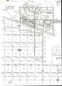
Map, Melbourne Metropolitan Area Base Map, 1957?
Sheet 254 of part of the Municipality of Nunawading and part of the Parish of Nunawading, showing roads, block numbers, creeks and contours mostly south of Canterbury Road.Sheet 254 of part of the Municipality of Nunawading and part of the Parish of Nunawading, showing roads, block numbers, creeks and contours mostly south of Canterbury Road. Prep. from State Aerial and Cadastral survey information, August 1957. Scale: 400 ft = 1 inchSheet 254 of part of the Municipality of Nunawading and part of the Parish of Nunawading, showing roads, block numbers, creeks and contours mostly south of Canterbury Road. city of nunawading, cadastral -
Whitehorse Historical Society Inc.
Map, Township of Norwich, ca 1850
Plan of the Township of Norwich being subdivision of Section III, Parish of Nunawading, County of Bourke, consisting of suburban farms, vineyard sites and town lots, for sale by auction by W. Casey & Co. [c. 1850]. Original in Vale Maps Collection, La Trobe Library.norwich village, vermont, parish of nunawading, vermont south, maps -
 Bendigo Historical Society Inc.
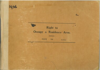
Administrative record - Right to Occupy Certificates, 1936
Twelve books containing stubs of Right to Occupy Certificates for 1936. Includes name and address of person receiving the Right to Occupy certificate and the description of the land including allotment, Section, City, Town, Borough or Township and Parish name. List of record Numbers in Box 906 Some items have pencil and pen marks and ink stains.right to occupy, central victoria -
 Federation University Historical Collection
Document, Victoria: Land Purchase, Edward Ager Wynne, 1856, 23 January 1856
.1 Document outlining the purchase of Lot No. 39: 16 acres, 3 roods, 9 perches situated in the County of Talbot, Parish of Glendaruel by Edward Ager Wynne of Melbourne for the sum of Seventeen Pounds Thirteen Shillings .2 Document outlining the purchase of Lot No. 30: 50 acres, 2 roods, 38 perches situated in the County of Talbot, Parish of Glendaruel bu Edward Ager Wynne of Melbourne for the sum of Fifty Pounds Fourteen Shillings and Nine Pence Both documents were witnessed by Major-General Edward Macarthur the Senior, Officer in Command of Our Land Forces Thick cream paper, hand writtenDate: 23 January 1856 Signature: E Macarthur - Major General of Our Land Forces Official Seal county of talbot, parish of glenaruel, acres, roods, perches, edward ager wynne, major-general, edward macarthue, land purchase agreement