Showing 13180 items matching "government-act"
-
 Bendigo Historical Society Inc.
Map - HAWKESTONE : COUNTY OF BENDIGO, December 1953
Map. Hawkestone, County of Bendigo, County of Talbot, Sutton Grange, Redesdale, Faraday, Elphinstone, Metcalfe, Coliban River. By authority W.M. Houston, Government Printer. Drawn and reproduced at the Department of Lands and Survey, Melbourne. December 1953. Price 5/-. (number 97 in map cupboard 1)W.M. Houston, Government Printer.map, bendigo, hawkestone. -
 National Vietnam Veterans Museum (NVVM)
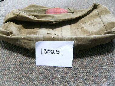
Equipment - Equipment, Army, Canvas Bag
Large Canvas Khaki Bag : label on bag stating "Aviator's Kit Bag" A.N 6505-1. Property of US Government. Two handles and zippered at top.Aviator's Kit Bag-AN 6505-1 Property of US Governmentcanvas bag, aviation. australia, 1800-1975 -
 Melbourne Tram Museum
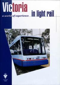
Booklet, Victorian Government, "Moving Victoria - a world of experience in Light Rail", c1998
Booklet - "Moving Victoria - A World of experience in Light Rail" - produced by the Victorian Government to advertise and market its expertise in Light Rail manufacturing and operation. Notes Melbourne trams, track infrastructure, Electrical systems and Asset Management. Includes images of Sydney Light Rail and Hong Kong vehicles. Has a forward by Mark Birrell, Minister for Industry Science and Technology (Minister from 1996 to 1999). Includes an extensive list of contacts, companies and their products. See item 7206 for a similar document c2003.Yields information about Victorian Light Rail manufacturing capacity.Booklet - 24 pages, centre stapled titled "Moving Victoria - a world of experience in Light Rail"victoria, tramcar manufacture, sydney, hong kong, melbourne, light rail, tramways, marketing -
Bendigo Historical Society Inc.
Map - SALISBURY : COUNTY OF BENDIGO, 1965
Map. Salisbury, County of Bendigo, Pompapiel, Yallook, Yarraberb, Yarrayne, Bullock Creek. Drawn and reproduced at the Department of Lands and Survey, Melbourne. Price $1.00. 1965. By authority A.C. Brooks, Government Printer, Melbourne. (number 28 in map cupboard 1)A.C. Brooks,Government Printer, Melbourne.map, bendigo, salisbury -
 Bendigo Military Museum
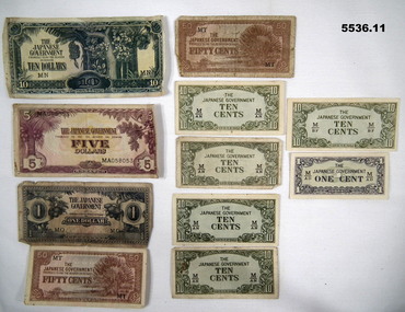
Currency - JAPANESE INVASION MONEY - PHILIPINES, Japanese Imperial Government, c1938-1945
Refer to Cat 95P. RAAF service of C.S. Cornelius NR 40595.This is a set of Invasion notes for the Philippines in WW2. Printed by Imperial Japanese Government. 1. Ten dollar note - white paper, dark green ink both sides. 2. Five dollar note - white paper, purple ink both sides. 3. One dollar note - white paper, blue ink both sides. 4. & 5. 50 cent notes - white paper, brown ink both sides. 6, 7, 8, 9, 10. 10 cent notes - white paper, green ink both sides. 11. Very small note - 1 cent. Front side printed in black and green ink. Rear in light black ink.ww2, philipines, invasion money -
Bendigo Historical Society Inc.
Map - BAMAWM : COUNTY OF BENDIGO, November 1954
Map. Bamawm, County of Bendigo. Sheet 2, Pannoobamawm, Diggorra. Elmore to Cohuna Railway Line. Township of Lockington. By authority W.M. Houston, Government Printer.Drawn and reproduced at the Department of Lands and Survey, Melbourne. November 1954. Price 5/- per sheet. (number 52 in map cupboard 1)W.M. Houston, Government Printermap, bendigo, bamawm -
 Bendigo Military Museum
Uniform - MESS DRESS, RACT, 1) and .2) DAVID KLEIN PTY LTD, 1) and .2) 1966
Royal Australian Corps of Transport mess dress belonging to Kevin John Herdman. Part of the Kevin John Herdman No. 397661 Collection, See Catalogue No. 5942P for details of his service record..1) Black jacket with two button-down breast pockets and two side pockets with flaps. Jacket buttons at the neck and down the front. Unit insignia on right collar. White starched false collar attached with studs. All buttons bear a unit insignia and are gold coloured. Major's rank insignia on each epaulette. Manufacturer's label on inside left. .2) Pair of black trousers with two white stripes down the outside of each leg. Buttons on waist band for attaching braces. .3) White elastic adjustable braces. .4) Black peaked cap with red band. Gold coloured braiding on peak. Brown coloured sweat band and clear plastic lining..1) On manufacture's label: 'DAVID KLEIN PTY LTD, PTY LTD, VICTORIA, 1966, (upwards arrow)'. On false collar: 'C.G.C.F., SIZE 15'. .2) On manufacturer's label: 'DAVID KLEIN PTY LTD, PTY LTD, VICTORIA, 1966, (upwards arrow)'. .3) Stamped on leather joiner: 'P-F, 10 73, (upwards arrow), 44'. .4) Inside cap: 'COMMONWEALTH GOVERNMENT CLOTHING FACTORIES, MELBOURNE,6 3/4'.uniform, mess dress, royal australian corps of transport, kevin john herdman -
Bendigo Historical Society Inc.
Map - CAMPBELL COLLECTION: BENDIGO AND DISTRICT MAPS, June 1953
Map. Marong, County of Bendigo, Scale 40 chains to 1 inch. Woodstock, Leichardt, Nerring, Sandhurst, Lockwood, Shelbourne. Drawn and reproduced at the Department of Lands and Survey, Melbourne, Victoria. By Authority : W.M. Houston, Government Printer. June 1953. Price 2/-. (number 403 in map cupboard 1)W.M. Houston, Government Printer.map, bendigo, agricultural lands -
Bendigo Historical Society Inc.
Map - WOODSTOCK : COUNTY OF BENDIGO, 26-9-17
Map. Woodstock, County of Bendigo, Derby, Leichardt, Marong, Shelbourne, Laanecoorie, Tarnagulla. L.5512. Photo-Lithographed at the Depatment of Lands and Survey, Melbourne, by W.J. Butson, 26-9-17. Price 1/-. By authority A.J. Mullett, Government Printer, Melbourne. (number 19 in map cupboard 1)A.J. Mullett, Government Printer.map, bendigo, woodstock -
Bendigo Historical Society Inc.
Map - DERBY : COUNTY OF BENDIGO, 1959
Map. Derby, County of Bendigo, Bridgewater, Inglewood, Tarnagulla, Woodstock, Leichardt, Loddon River. By authority A.C. Brooks, Government Printer, Melbourne. Drawn and reproduced at the Department of Lands and Survey, Melbourne. 1959. Price 2/-. (number 54 in map cupboard 1)A.C. Brooks, Government Printer, Melbourne.map, bendigo, derby -
 Lara RSL Sub Branch
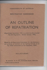
Booklet, Government Printer, An Outline of Repatriation
Printed for Australian Infantry personnel during World War 2 to help with repatriation on return to AustraliaUsed by World War 2 service personnel to assist with repatriation on return from active service to Australia.A booklet coloured khaki with a cover made from light cardboard and 64 pages made from paper.On the front Cover from top to bottom: Commonwealth of Australia; Repatriation Commission; AN OUTLINE OF REPATRIATION; (Republished September, 1943, to conform to the amended Acts and Regulation, Revised January, 1941); (Issued by the Repatriation Commission for the information and guidance of members of the Fighting Services of the war which commenced on 3rd September, 1939); Melbourne; By Authority: H.E. Daw, Government Printer, Melbourne T.1034/12.43-C.454/45 See images for content on front and rear covers.commonwealth of australia, repatriation commission, world war 2, ww2, repatriation, aif, australian infantry forces, melbourne, government printer, navy, army, air force -
 Bendigo Military Museum
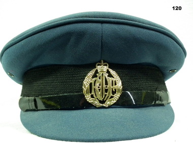
Headwear - CAP, PEAKED, RAAF
Navy blue RAAF hat with plastic gold coloured badge. Badge: RAAF inside a wreath.headwear raaf, uniforms -
 Federation University Historical Collection
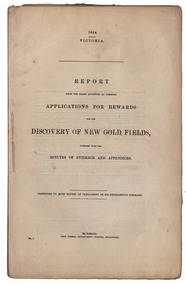
Book - Gold discoverers, John Ferres, Government Printer, Report from the Board Appointed to Consider Application for Rewards for the Discovery of New Gold Fields Together with the Minutes of Evidence and Appendices, 1864, 1864
31 paged, stitched report relating to rewards for the discovery of new goldfields in Victoria. Copy of the report with handwritten annotations by Keith Rash. .2) Duplicate copy. gold, mining, rewards, goldfield discovery, minutes, evidence, robert brough smyth, j.f. sullivan, james esmond, john dunlop, t.l. madgett, w. brownbill, daniel brophy, alexander wilson, peter paterson, edward hill, mary kerr, henry dowling, charlotte edwards, r. reynolds, a.s. wilson, t.l. williams, wombat flat, jim crow, keith rash, gold discovery, gold discoverers, peter wright, daylesford, creswick's creek, fiery creek, st arnaud, brown hill, ballarat, hepburn, mcivor, avoca, steiglitz, dolly's creek, taradale, woad yaloak, f.a. powlett, f. kawerau, david armstrong, john jones, h. swindells, w. lonsdale -
 Federation University Historical Collection
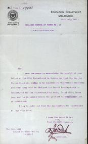
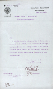
Letter - Correspondence, Education Department Correspondence on 'mourning' letterhead, 1901, 18/07/1901
Queen Victoria on 22 January 1901. Mourning stationery for letters, both writing paper and envelopes, was printed with black borders, of varying depths, as a token of bereavement. Black sealing wax, black leather blotters, and jet paperknives were also sometimes used. Foolscap letters on Education Department Melbourne letterhead, relating to Harold Leckie, J. Brangan and William J. Lakeland.victorian education department, ballarat school of mines, theoretical chemistry, metallurgy, harold leckie, joseph j. brangan, willaim j. lakeland -
 Federation University Historical Collection
Letter - Correspondence, Education Department Correspondence letterhead, 1901, 24/06/1901
Queen Victoria on 22 January 1901. Mourning stationery for letters, both writing paper and envelopes, was printed with black borders, of varying depths, as a token of bereavement. Black sealing wax, black leather blotters, and jet paperknives were also sometimes used. Foolscap letter on Education Department Melbourne letterhead, with a black edging signifying mourning for Queen Victoria. The correspondence concerns Ballarat School of Mines leading Teacher T.S. Hart and the Technical Schools Conference. victorian education department, ballarat school of mines, technical schools conference, t.s. hart, thomas hart -
Federation University Historical Collection
Book, Report from to the Select Committee on Gold Prospectors, 1862-1863, 1862-3
Blue foolscap goverment report on gold prospectors. gold prospectors, mount blackwood, inglewood, william mccrea -
 Rutherglen Historical Society
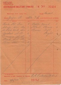
Document - Receipt for uniform and equipment, 1948
Given to B.S. Jasper when he was a cadet in the A.M.F.Orange coloured paper receipt from Australian military forces for uniform and equipment for B Jasper. Printed on paper. Pencil writing"Received from Army No___ Rank Cadet / Name Jasper B. Unit Btn. G. S. / Signature of QM. RQMS or CQMS /F.W. Palmer"australian military forces, amf, military service, cadets, brian jasper -
 Rutherglen Historical Society
Booklet - Book, Can We Help You?, 1938 (Exact)
Mr Catterall, Joe & Mr L.J. Romey were partners in a cyaniding operation to obtain gold from the Southern Consuls Mine after second world war.Booklet printed on paper with a light green covergold mining, mining industry, miners rights, mining licences -
 Beechworth RSL Sub-Branch
Jacket battle dress, 1977
standard style of a jacket battle dress from the late 1940s to 1982; it was used for parade dress; this jacket was worn by a warrant officer class 2 of the Royal Australian Electrical and Mechanical Engineers.This jacket has historical significance because it representative of a standard style service battle dress worn by soldiers of the Australian Army Post WW2 until the introduction of the modern polyester cotton uniforms. It is also in excellent condition, which is special considering it's age. Waist length jacket, with two breast pockets either side, collar, olive green, two shoulder patches on both side ones says “Royal Australian Electrical & Mechanical engineers” in Bright yellow/gold writing on a in navy blue shoulder patch; a ranking insignia of Warrant Officer class 2 above the cuff of both sleeves Label located inside the jacket on the right hand side it says “A.G.C.F. VIC 1977 8405.66.025.6423 Size of chest: Size. 109/112PR. Yarra Falls. Batch 21657. Dry clean only Crease upper half of labels only.jacket, jacket battle dress, jacket khaki -
 Beechworth RSL Sub-Branch
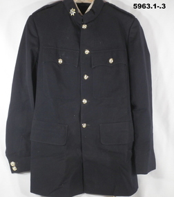
Jacket, Service Dress, Australian Government Clothing Factory, 1981
The insignia on the collar of this jacket indicates that its wearer was a Marine Technical Propulsion Petty Officer in the Royal Australian Navy.Double breasted jacket in dark navy colour with notched lapels, chest pocket on left side and two hip pockets. Eight gold buttons fasten the jacket in front, each bearing Navy insignia of a crown above an anchor above the word "AUSTRALIA". Sleeves each bear navy blue patch on upper shoulder with the word "AUSTRALIA" embroidered in gold thread. Cuff of sleeves carry three gold buttons as previously described. Lapel collar has an embroidered patch on both sides which includes an ornately embroidered crown, above a propeller, above a six-pointed star above a "P"; all insignia is embroidered with gold thread. Jacket contains two interior chest pockets and is lined with synthetic material. Buttons carry embossed text "STOKES/MELB" Shoulder badges read "AUSTRALIA" Interior chest label reads, "A.G.C.F./VIC. 1981/8405-66-100-2323/SIZE. 104P/MATCHING TRS/SIZE 99P/R.A.N./MADE IN/AUSTRALIA." Handwritten on this label are the annotations "5114247/BAUMGARTEN"chief petty officer stoker, royal australian navy -
Woodend RSL
Uniform - Battle Dress jacket, trousers, lanyard and neck tie, 2nd Half 20th Century
This battle dress uniform dates to the latter half of the 20th century. It was issued to the “Prince of Wales’s Light Horse’ Regiment however the date of issue for all items is unknown. A Prince of Wales Light Horse unit was based in Kyneton, a neighboring town to Woodend. This uniform likely originated from the Kyneton area. The jacket and trouser style was still in use during the Vietnam war in which the Regiment participated. Considering the condition of the item, it is highly likely that the uniform has not seen active service.This battle dress uniform is representative of a type of standard issue Army uniform, dating to the later half of the 20th century. It is also in very good condition.Khaki, wool jacket with yellow lanyard over the right shoulder. Prince of Wale's light horse embroidered on a yellow flash, stitched on both shoulders. Cropped style with two pockets on front, four khaki buttons and waist belt. Two epaulets and a manufacturer's label on inside left hand side. Khaki, wool trousers with buttoned bracers and iron pleats on both trouser legs. Manufacturers label also on inside of pants (right hand side). Khaki neck tie.battle dress, jacket, trouser, neck tie, lanyard, khaki, wool, fabric, uniform, prince of wales light horse, army -
 Woodend RSL
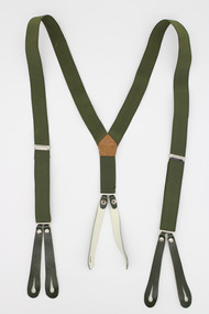
Braces
These braces date to the latter half of the 20th century. They were issued to the “Prince of Wales’s Light Horse’ Regiment, however the date of issue is unknown. A Prince of Wales Light Horse unit was based in Kyneton, a neighboring town to Woodend. This jacket likely originated from the Kyneton area. The uniform type was still in use during the Vietnam war in which the Regiment participated. Considering the condition of the item, it is highly likely that it has not seen active serviceThese braces are representative of a piece of standard issue Army uniform. They are also in very good condition.Dark green leather and elastic braces. The section that fastens to the back has two leather attachments with holes and slits for fastening to trousers. This section extends upwards and divides into two elastic straps to afix over shoulders. There is one metallic clip that holds that elastic in place near the front of the brace, where it is folded over and can be adjusted. The two strips then end with two leather attachments each, with holes and slits for fastening to the front of a pair of trousers. The leather components are textured on the exterior and smoother on the interior. The interior sections of the leather pieces are also cream coloured. battle dress, braces, uniform, armoured, cavalry, prince of wales light horse -
Woodend RSL
Shirt
The Skill at Arms Badge is awarded to members who achieve the appropriate marksman score during the conduct of the Applied Marksmanship Practice, IAWKhaki short sleeved shirt called “polyester” with rectangular embroidered rising sun patch and Skill at Arms badge (square crossed rifles patch) on left sleeve. Two front pockets -
Woodend RSL
Shirt, 1982
This shirt was owned by Matthew Calvitto. Matthew moved to Woodend with his family at the age of one. He commenced his career in the 56th Battalion Army Reserve unit. In 1999 or early 2000 he volunteered to join the regular Army. He was posted to the 6th Royal Australian Army Regiment, D company. His initial training was at either Shaulwater Bay or Conundra. After his training he served for 6 months in Timor, in either the second or third rotation. Matthew and the other members of the D Company received battle honours. Matthew was their forward scout, as well as a marksman, which you need to qualify for every year.As an item that belonged to Matthew Calvitto, a local Woodend veteran who received battle honour for his service in Timor, this shirt has social and historic significance. The provenance of the item is know as it was donated by family members. The item is also represenantive of a type of military shirt that was issued to Army personnel during the late 20th century. The item is also in very good condition. Khaki short sleeved shirt with a short pointed collar and two front chest pockets. Each pocket is fastened with one semi opaque beige plastic button. There are seven identical buttons that fasten the front of the shirt. Each shoulder has an epoulette that fastens with one of these plastic buttons near the neck. yellow D company 6th royal australian regiment. red a collectors item infantry or military police or 4th battalion, blue 1 royal victorian regiment.matthew calvitto, calvitto, woodend, 56th battalion, 6th royal australian army regiment, d company, timor, marksman -
Port Melbourne Historical & Preservation Society
Book - Reference, Victorian Government, Victoria Felix, 1985
"Victoria Felix - A celebration of the 50th Parliament of Victoria 1856 -1985" Author Elizabeth Wood Ellem. 28 page booklet, illustratedstate government victoria, celebrations fetes and exhibitions -
 Ballarat Tramway Museum
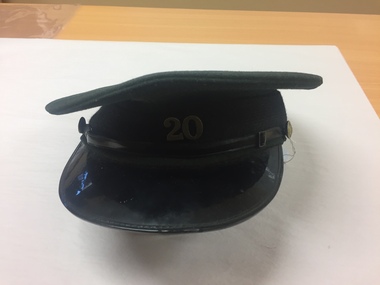
Uniform - Cap, Commonwealth Government Clothing Factories Melbourne, 1960's
Demonstrates uniform cap manufacture, badge and has a strong association with a former Ballarat Driver - Norm HuntSEC Motorman/Drivers/Conductors cap - green cloth exterior, grey cotton interior lining, brown leather internal hat band, black cotton hat band on exterior with a plastic band at the front half of the cap terminating in two small SEC metal buttons on either side, black plastic peak fitted with cap or badge No. 20, nickel plated silver, in the centre of the cap above the hat band. Sewn on the inside is a label "Commonwealth Government Clothing Factories Melbourne (very faded)" and stamped "6 3/4". See also Reg. Item 3044 for an ex Geelong cap. Stored with the cap are a copy of the SEC By-Law 1, August 1965 and the Federal Rules of the ATMOEA - 1969 and three SEC tickets.tramways, trams, uniforms, cap badge, cap -
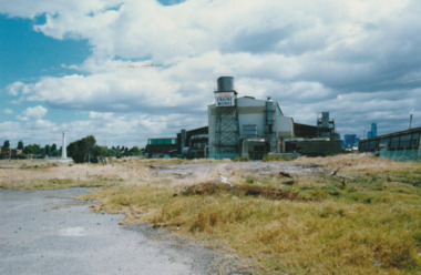 Port Melbourne Historical & Preservation Society
Photograph - Australian Government Engine Works, c.1985
Commonwealth Government Engine Works prior to demolitionAustralian Government Engine Works, Port Melbournecommonwealth government engine works -
Bendigo Historical Society Inc.
Map - CAMPBELL COLLECTION: BENDIGO AND DISTRICT MAPS, March 1947
Map. Mandurang, County of Bendigo, Sandhurst, Strathfieldsaye, Sedgwick, Sutton Grange, Ravenswood, Lockwood. Scale 40 chains to 1 inch. Drawn and reproduced at the Department of Lands and Survey, Melbourne, March 1947, price 2/-. By Authority : J.J. Gourley, Government Printer, Melbourne. (number 402 in map cupboard 1)J.J. Gourley, Government Printer.map, bendigo, allotments -
Bendigo Historical Society Inc.
Map - CAMPBELL COLLECTION: BENDIGO AND DISTRICT MAPS, August 1952
Map. Nerring, County of Bendigo, Yarraberb, Neilborough, Leichardt, Marong, Sandhurst, Huntly. Scale 20 chains to 1 inch. Drawn and reproduced at the Department of Lands and Survey, Melbourne, Victoria, August 1952. Price 2/-. By Authority J.J. Gourley, Government Printer, Melbourne. (number 404 in map cupboard 1)J.J. Gourley, Government Printermap, bendigo, allotments -
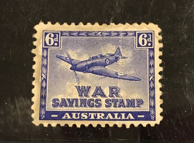 Surrey Hills Historical Society Collection
Work on paper - War Savings Stamp, 6d WW2 war savings stamp, 1941-1944
These stamps were issued during WW2 and designed to be stuck into a war savings stamp booklet. When these were filled, you could redeem them for a £1 or £5 War Bond. This specimen is not watermarked indicating it was a re-issue of the earlier version with a watermark. Issued between August 1941 and March 1944. Designed and produced by the Government Stamp Printer. Although the stamp has been called the "Spitfire" for over 70 years, the image of the plane depicted is either a Boulton-Paul Defiant (with a turret mounted behind the cockpit) or a Hurricane rather than a Spitfire. A 6d stamp Australian War Savings stamp in Imperial Blue and white. Loosely held in a philatelic mount. stamps, war savings stamps, planes, second world war, fundraising