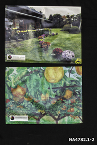
Showing 2439 items matching "orchard"
-
 Ringwood and District Historical Society
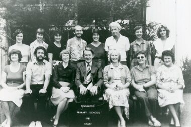
Photograph, Ringwood State School - Staff, 1981
Black and white photograph - Staff, 1981"Attached to photograph" Back Row- L to R: Anne Orchard, Marj Smith, Dawn Colville, Tom Exon, Dianne Jones, John Duffy, Isobel Marshall, Mandy Irvine. Front Row- L to R: Jan Burne (T.C), Stephen Gough, Maureen Gray, Baden Chadwick (Pr), Lindsay Bolden, Pam Wilson, Margaret Beuthan. -
 Mt Dandenong & District Historical Society Inc.
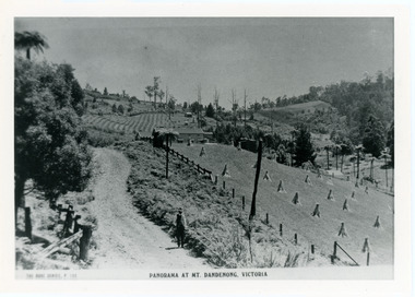
Photograph, View From Corner of Doughty's Road and Barbers Road 1913
John Lundy-Clarke grew up in the Kalorama/Mt Dandenong area and later in life (1972-74) began to write a comprehensive history of the area working from an original settlement map in an effort to cover all areas. Taken c1913, this photograph gives a clear indication of where significant buildings were located in relation to one another. Barbers Road is running through the picture with the guest house 'Kia-Ora' , built by George Barber in the centre. High on the skyline on the left is the 'Mountjoy' guesthouse, indicating the location of The Gap, or FiveWays. The small 'boxy' house above 'Kia-Ora' is 'Iona' built by the Paynter family who also built 'Mountjoy'. The Jeeves property 'Kalorama' is to the right of 'Iona' and this is the area you now look to from the FiveWays Lookout. The man in the photo is wearing a trilby hat so is probably a Rose Series employee - a feature in many Rose Series postcards.Black and white photograph that is a copy of Rose Series Postcard # 156. A man can be seen walking down an unmade road with haystacks to his right. Buildings and crops can be seen on the hillsides. Handwritten inscription on reverse by John Lundy-ClarkeView from corner of Doughty’s and Barbers Road 1913. “Kia Ora” in centre Paynter’s “Iona” near center skyline above “Kia Ora” with “Kalorama” on its right and Peter’s hut of the time below it among orchard trees. “Mountjoy” is on left skyline. W. Haye’s home is centre left. Hay paddock is Barbers Lot 25 Village Settlement.kia-ora, iona, kalorama, mountjoy, guesthouse, guest house, barbers road, doughty's road, paynter, jeeves, george barber -
 Mt Dandenong & District Historical Society Inc.
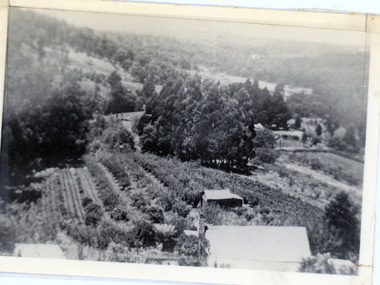
Photograph, 1913 View Over Logan's House in Village Settlement, 1913
Photograph taken in 1913 from Barbers Road showing the view down the valley. Roof in foreground is house on Bob Logan's Lot 28 in the Village Settlement. This photograph has a detailed inscription on the back handwritten by John Lundy-Clarke in 1974.1913 view over Logan’s house on Village Settlement Lot 28 taken from Barber’s Road. This is the house that the runaway log leaped over in 1930 to land far down the orchard row beyond the house. “Shiloah” is centre partly behind the clump of trees and the paddocks of Child and Richardsons pioneer selections are in the background. Link Road is centre right.logan, bob logan, robert logan, barbers road, shiloah, child, richardson, link road -
 Ringwood and District Historical Society
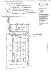
Document - Subdivision Plan, LP23855 Part of Crown Allotment 14B, Parish of Ringwood, County of Mornington, Vol 6687 Fol 394 - 1952
LANDATA Land Victoria plan printout circa 2008Map includes Cuthbert Street, Orchard Grove, and Lowen Avenue (formerly part of Balfour Avenue), Heathmont. Other markings include SP25736, LP98835 and LP40209. Accompanying pencil sketch on light cardboard backing includes sales notations on lots 4 to 8 on Sunset Drive and Cuthbert Street and comment - Roads to be formed & E.L&W provided by vendor. -
 Whitehorse Historical Society Inc.
Memorabilia - Table mats, 2016
Table mats presented after a visit to Schwerkolt Cottage and Museum Complex by delegates from City of Whitehorse's sister city MatsudoSymbol of White horse City and City of Matsudo's friendshipTwo table mats presented to WHS by our sister city Matsudo. Number 1 shows Togo Tea House built in 1884 with the garden in the foreground with pots of chrysanthemums in many colours. An insert in the left hand bottom corner 'Whitehorse-Matsudo Sister Cities Celebrating Friendship'. With black circle on left side with a yellow and pink flower and 1971 on it. Number 2 is Named ' Pear Orchard' with background of green trees gold pears hanging from branches. Insert in left hand bottom corner as above.Whitehorse- Matsudo Sister Cities Celebrating Friendship.domestic items, food & drink consumption -
 Greensborough Historical Society
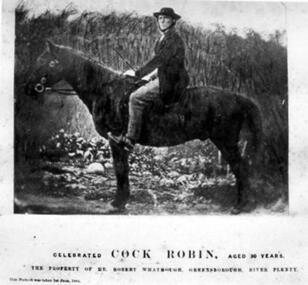
Photograph - Digital image, Whatmough's "Cock Robin", 09/01/1850
Photograph of the horse "Cock Robin" owned by Robert Whatmough. Mr Robert Whatmough operated an orchard and commercial nursery on the property 'Willis Vale' at Greensborough and was related to Charles Partington by marriage. [Reference: The Argus - Wednesday 9 January 1850 Page 4... The River Plenty Races. – These races came off yesterday. The Plough Inn Cup of £25 was won by Mr. Beale’s Wallaby, beating three others. A pony race was won by Mr. Whatmough’s Cock Robin. A purse of £10 was won by Mr. Haye’s Gazelle.] The Whatmough family were Greensborough pioneersDigital copy of colour photograph.Photograph has printed caption: Celebrated Cock Robin aged 30 years. The property of Mr Robert Whatmough, Greensborough River Plenty. Date is illegible.cock robin, robert whatmough -
 City of Moorabbin Historical Society (Operating the Box Cottage Museum)
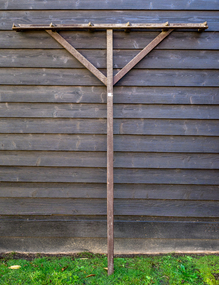
Farm Equipment, Rake, large Hay c1900, c1900
A hay rake is an agricultural rake used to collect cut hay or straw into windrows for later collection (e.g. by a baler or a loader wagon). It is also designed to fluff up the hay and turn it over so that it may dry. The next day it is spread again, so that the hay dries more quickly. Early settlers established productive market gardens, poultry,. pig and dairy farms , orchards and vineyards on the land in the 'Henry Dendy Special Survey Brighton 1841' - now Ormond, Bentleigh, East Bentleigh, Brighton, This hay rake is typical of the type used by early settlers in Moorabbin Shire c1900Large wooden Hay rake , hand made c1900farm equipment, hay rakes, hammers, early settlers, market gardeners, blacksmiths, tools, building equipment, moorabbin shire, bentleigh, mckinnon, highett, cheltenham,ormond -
 Surrey Hills Historical Society Collection
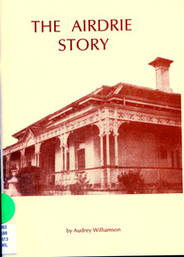
Booklet, The Airdrie Story
Paperback with a brown and apricot cover with a photo of Airdrie in 1936. [56] pages with illustrations, maps, photos including portraits; also appendices of Profiles and Personalities and a Listing of Bequests and sources. non-fictionairdrie house, canterbury, old age homes, society for the care of aged or incapacitated nurses, audrey williamson, rochester road, shrublands estate, george shierlaw, sharrott house -
 Ringwood and District Historical Society
Flyer, Stillwell & Stephens Pty. Ltd, Brochure - Multiple Properties for Public Auction at Box Hill, Ringwood, Wonga Park and Clarinda - 28th November, 1934
Seven-page brochure advertising Mortgagees' Realising Sale by Public Auction on Wednesday, 28th November, 1934 for properties at Box Hill, Ringwood, Wonga Park, and Clarinda (via Oakleigh), including photographs, property descriptions, and terms of sale.Auction Commencing at 2.15 p.m. in the Orient Line Auction Rooms, 352 Collins Street, Melbourne. Solicitors: Messrs. Madden, Butler, Elder & Graham, 406 Collins Street, Melbourne. (Agents) H.P. Knight & Co. Property Salesmen and Subidivisional Experts, 315 Collins Street, Melbourne, 'Phones: Central 10615, 10616. Attractive Residential, Orchard, and Market Garden Properties, and Public Hall and School Rooms. 1. Wonga Park via Ringwood - "Holme Bush" off Warrandyte Road, Part of Lots 14 and 15, Ringwood Orchard Estate, approximatgely three miles (north) of Ringwood Railway Station - 64 Acres. 2. 17 Bishop Street, Box Hill - timber residence. 3. Greenwood Avenue, Ringwood - On East Side, 150 feet 3 inches South of Bedford Road - timber attic residence. 4. Ringwood - Wantirna Road, South-east corner of Canterbury Road - Orchard Property of approx. 11-1/2 Acres. 5. Box Hill - Whitehorse Road, South-east corner of Linsley Street - Timber building utilised as a Public Hall and Private School. 6. Clarinda vic Oakleigh, Talbot Crescent, off Centre Road - Home on 10 acres of land. -
 University of Melbourne, Burnley Campus Archives
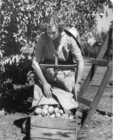
Photograph - Black and white print, Athol Shmith Studio Illustrative Photograhy, Student Picking Pears, 1946-1947
Black and white photograph. Female student, Elspeth Newman, empyting pears out of canvas bag, attached to her with a harness, into wooden packing case. Pear tree and wooden ladder behind her.On reverse, Athol Shmith Studio Illustrative Photography 125 Collins Street, Melbourne, C.1. Cent 27. No. 17701 Position E.elspeth newman, pears, canvas bag, packing case, athol shmith studio, students working outside, orchard, pear tree, ladder, publicity -
 University of Melbourne, Burnley Campus Archives
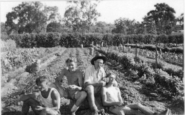
Photograph - Black and white print, Burnley Gardens Vegetable Patch C.R.T.S. Students 1948, 1948
Laminated copy of black and white photograph of C.R.T.S. (Commonwealth Reconstruction Training Scheme) students taking a rest, probably harvesting potatoes.On reverse, "Burnley Gardens vegetable patch. C.R.T.S. Students 1948 L. To R. Eliz Rohan (sic), D. Hughan, I. Lintermans, R. Parkinson."vegetable gardens, potatoes, eliz rohan, david hughan, i. lintermans, r. parkinson, crts, 1948, commonwealth reconstruction training scheme, orchard -
 University of Melbourne, Burnley Campus Archives
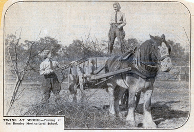
Newspaper - Newspaper Cutting, Twins at Work and Doing Time, 1930-1940
Two newspaper cuttings. 1. two female students with a horse and cart, with the caption: "Twins at work - Pruning at the Burnley Horticultural School." 2. a story about egg production at the College, featuring a hen called Matilda Jane, and with an interview with Mr AW Jessep, with the sub-titles "Doing Time" and" Utopia."burnley horticultural college, female students, pruning, a.w. jessep, poultry, egg-laying competition, horses, students working outside, draught horses, orchard -
 University of Melbourne, Burnley Campus Archives
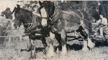
Newspaper - Newspaper Cutting, The Herald, Girl Gardeners - Pupils Taught at Burnley Farm, 1937
Newspaper cutting from "The Herald", April 30, 1939. The article discusses the course syllabus and potential jobs after graduation. There are two photos, one with a girl ploughing, pulled by two cart horses and the second of a girl surrounded by grape vines and grapes, with the caption: " 'Burnley' girls are ready for any gardening emergency."the herald, burnley horticultural college, students, female students, syllabus, careers, horses, students working outside, orchard, grapes -
 University of Melbourne, Burnley Campus Archives
Photograph - Black and white print, The Sun, Students Working in Vegetable Plots, c. 1964
Large black and white photograph. Instructor, Jack Russell, weighing vegetables with student, Russell Mason, Leigh Issell walking with cabbage in his hand. "Photographer's Caption Sheet-Sun" attached. Operator is "Bugden."instructor, jack russell, vegetables, students, russell mason, leigh issell, cabbage, orchard, weighing vegetables, student plots -
 University of Melbourne, Burnley Campus Archives
Album - Colour prints, Photograph Album Burnley College Buildings, 1981-1985
Collection of 34 photographs in a cardboard photograph album with plastic pages. Most stamped 20 Aug 1985 on reverse, Quad construction 1981.(1) Administration Building front entrance. (2) Administration Building front view. (3) Administration Building front centre. (4) Administration Building, back entrance, Hall end. (5) Administration Building, back centre. (6, 7) Student Amenities Building. (8) Quad 5. (9, 10) Library, front completed 1982. (10A) Library, back. (11) Nursery. (12) Nursery (13,14) Quads 2,3,4. (15) Quad 6 back. (16) Engineering (17) Library front from the Bull Paddock. (18) Dairy. (19) Principal's Garage, now Herb Garden. (20) Soil Bins old Nursery. (21) Old Nursery. (22) Greenhouse old Nursery. (23-25) Landscape Shed. (26) Orchard Shed. (27) Orchard Shed and Kiwi Fruit vine. (28,29) Plant Science Laboratory. (30) Energy Efficient Glasshouse old Nursery. (31) Glasshouse old Nursery and Potting Shed. (32) Energy Efficient Greenhouse old Nursery. (33) Potting Shed old Nursery.quad construction, administration building, student amenities, library, nursery, bull paddock, dairy, principal's garage, herb garden, soil bins, greenhouse, landscape shed, orchard shed, kiwi fruit vine, plant science laboratory, energy efficient glasshouse, potting shed -
 City of Moorabbin Historical Society (Operating the Box Cottage Museum)
Tool - Tools small steel socket spanner
Early 20thC settlers need a different spanner for each size nut or bolt. Now socket spanners often come as a "socket set" with many different sizes or types of sockets to fit the heads of different-sized fasteners. Among the early settlers in Moorabbin Shire were blacksmiths who made tools for the other settlers who were establishing the homes, market gardens, farms, orchards and various businesses. Early settlers were self reliant and repaired their own equipment for kitchen,dairy, farm, horses, carts using various tools This spanner is typical of the type used by early settlers in Moorabbin Shire early 20thCA small steel socket spannerhammers, early settlers, market gardeners, blacksmiths, tools, building equipment, moorabbin shire, bentleigh, mckinnon, highett, cheltenham, mcewan james pty ltd, melbourne, bunnings pty ltd -
 University of Melbourne, Burnley Campus Archives
Photograph - Colour print, The Australian Garden Lover, "An Australian Horticultural School.", 1926
The 4 bottom photographs used as an illustration in, "Green Grows Our Garden," A.P. Winzenried p 52 and also used in the Centennial Display mounted on board. The espaliered fruit tree was located in the old nursery trained by George Russ. Top right orchard spraying. Bottom left View of Pavilion showing Luffmann's pond and a Pinus radiata planted in the 1860's. Bottom right A.W. Jessep (Principal) and E.E. Pescott (Lecturer). outside Principal's Residence. E.B. Littlejohn.See detailed description in paper catalogue and B91.404 for Journal Article.Colour photograph of part of the cover of , "The Australian Garden Lover," Vol. 2 No. 7 October, 1926, entitled, " 'An Australian Horticultural School.' Enterprise at Burnley, Vic." ella chalmers (née fry), green grows our garden, a.p. winzenried, centennial display, a.w. jessep, principal, e.e. pescott, lecturer, principal's residence, e.b. littlejohn, espaliered fruit tree, old nursery, george russ, orchard spraying, pavilion, pinus radiata, ponds., lily ponds, luffmann ponds -
 Ringwood and District Historical Society
Photograph, Hunt Residence and family - Bedford Road Ringwood. c1910
Black and white photograph of two men behind a horse and plough. A lady is holding the horse and is accompanied by a little girl. (2 copies)Written on rear of backing sheet: "Rear 8 Bedford Rd. 'Hunt's Orchard' - this now part of Catholic School grounds. Walter hunt (with plough) at rear residence 8 Bedford Rd. Mrs. Hunt holding horse with daughter Laureen (later Mrs. Bob Lynch, Thomas St.). Also Charlie Williams at left. House next door is present (1970) Catholic Convent". -
 Eltham District Historical Society Inc
Document - Certificate of Title, Landata, Vol. 4930 Fol. 985900, Crown Portion 15 Section 5, Parish of Nillumbik, County of Evelyn, 1925
(Cancelled) Certificate of Title originally issued for Crown Portion 15, Section 5 to Robert David Taylor, of Eltham, County of Evelyn, Farmer, 13 March 1925. It is with this title that the land allotment was subdivided into 48 lots. The title shows the issuance to Robert David Taylor with encumbrance placed upon it by immediate former owner, Hugh Patrick Keogh, a former member for Gippsland and Melbourne Real Estate Agent. Following Taylor's death in 1934 the title passes to his Executors, sons Robert David Taylor of Bible Street, Eltham and William McLelland Vance Taylor of Northcote. The property is then sold to Frank Stokes who develops the Stokes Orchard. Compulsory acquisitions by the Melbourne Metropolitan Board of Works and State Electricity Commission show provisions of easemenst for town water supply and high voltage power transmission lines. Subsequent lots are then sold off with the development of the Stokes Orchard Estate residential development in the mid to late 1970s. A History of the Development of Crown Allotment 15, Section 5, Parish of Nillumbik – Stokes Orchard Crown Allotment 15, Section 5, Parish of Nillumbik (CA15) is a square allotment of 158 acres or approximately a quarter of a square mile. It lies just beyond the eastern end of Pitt Street, south of Nyora Road to the northern end of Eucalyptus Road and extends east from Eucalyptus Road to Reynolds Road. The topography of CA15 is generally steep, sloping up to a hill near the centre of the land, the ridgeline passing through the properties along the southern side of Diosma Road. Eucalyptus Road is a straight north-south road with its northern end at the north west corner of CA15. Until the end of the 1970s this road was an un-named Government Road and was largely not open to traffic. With residential development in the 1970s the road was constructed, and the council allocated the name obviously in recognition of the predominant species of the local bushland. CA15 was purchased from the Crown by George D’Arley Boursiquot, a prominent Melbourne printer, on 28th October 1852. On November 23, 1922, former Member for Gippsland and Melbourne Real Estate Agent, Hubert Patrick Keogh purchased the allotment then sold it March 13, 1925, to local farmer, Robert David Taylor, a former Shire of Eltham Councillor (1911-1920) and Shire President (1919). Taylor had extensive land holdings stretching west towards Bible Street and Main Road. The Taylor home was situated at the top of the hill in Bible Street at present day 82 Bible Street. At the time of Taylor’s purchase in 1925, CA15 was subdivided into 48 lots that could be described as small rural properties or large residential lots. A typical lot size was one hectare or 2.5 acres. The subdivision created two roads, Nyora Road, and Diosma Road, each following an irregular alignment between Eucalyptus and Reynolds Roads. However, the lots were not sold off separately nor were the roads constructed. The land effectively remained as one parcel for many further years. Robert David Taylor died November 30, 1934, and probate was granted to his son of the same name, Robert David Taylor of Bible Street, Salesman and William McLelland Vance Taylor of 73 Emmeline Street, Northcote, Clerk, with the transfer of the land into their names on July 8, 1935. Frank Stokes worked as a qualified accountant at Kennons leather factory in Burnley, while living at 1 Thomas Street, Mitcham. He suffered from migraines and wanted to return to working the land (he had previously worked on farms and orchards since coming to Australia from England in 1926, both in WA and Vic.). He first travelled to the district by train in July 1942 to find land with the intention to establish an orchard. By chance he met Arthur Bird of Bird Orchard (bounded by Pitt Street, Eucalyptus Road, and Wattle Grove) and they got talking over their common interest. Arthur put Frank up for the night and pointed out the land, 158 acres- part of the Taylor Estate- £900, Crown Allotment 15, Section 5, Parish of Nillumbik (CA15) somewhat diagonally opposite Bird Orchard. Stokes applied through the Riverina Agency to purchase the land who in turn applied for permission from Canberra to sell as there was a new government regulation introduced during the Second World War banning land sales except for immediate production. Stokes obtained a loan on his Mitcham house of £600 @ 5% and paid £450 deposit with quarterly payments of £15 spread over 5 years. Stokes was assisted and advised by Arthur Bird who farmed the neighbouring orchard. In early 1943 Stokes took possession and would catch the train out to Eltham on Fridays after work and began building a hut on the corner of Nyora Road and the Government Road (Eucalyptus Road) for shelter and to lock up tools. He established an orchard on the central western part of the land through the centre of which ran a natural waterway (part of the present-day linear park) and was able to pay a neighbour (Hawkins) to help with clearing and fencing 25 acres, and with a horse and single furrowed plough, planted approximately 2,500 fruit trees - cherries, peaches, plums, almonds, pears, apricots and lemons as well as a few apples and oranges; a massive task. Aerial photographs from the 1940s through to the 1990s clearly show the orchard with most of the larger CA15 site remaining as natural bushland. A huge problem was hares and rabbits eating all the new buds off the tiny trees. As well as laying poison he painted the trees with a mixture of cow manure and lime, often working by moonlight. Procurement of wire and wire netting was difficult because of the war but after much effort he obtained a permit from the Agricultural Department for supplies in March 1944. In February 1945 Stokes applied for a permit to build a “packing shed” as no house building was allowed. It was to be 33 feet x 21 feet and cost £312. It was constructed mostly from second-hand materials, which were hard to obtain, especially iron for roofing. Stokes finished work at Kennons on October 31, 1945, and in March 1946 he sold the family home at Mitcham for £1,230 plus £170 for furniture. On May 15, 1946, title to the CA15 property was issued to Frank Howard Alfred Stokes, Orchardist and Gladys Ethel Stokes, Married Woman, both of Pitt Street, Eltham. The family of five then moved into the very unfinished “packing shed” at Eltham, which was a struggle to weatherproof. Eventually rooms were divided off and lined with hessian bags and whitewashed. Their income was firewood (cut and sold), selling rockery stones and cut Sweet Bursaria. (It was discovered during the 1940s that Sweet Bursaria contained the sunscreen compound Aesculin. The RAAF utilised this compound from Sweet Bursaria during WW2 for pilots and gunners.) The orchard’s first fruit sale was a half-case of Le Vanq peaches in December 1947 for the price of 8 shillings. In 1956 plans for house were drawn and Glen Iris bricks purchased (1956 Olympic Rings variant). The building of the house commenced in 1957 - 12 feet of original packing shed was removed – and was completed in 1959. Water was connected from newly built pressure storage on the property at the end of 1959 and the electricity connection for the first time at 3pm on April 29, 1960. The house remains to present day (somewhat modified) at 1 Nyora Road, home to Nyora Studio Gallery. On occasions, spare remnants of the 1956 bricks have been known to be unearthed in gardens on the estate as they were utilised by Frank Stokes to fill in rabbit holes. On May 26, 1950, a parcel of land was compulsorily acquired by the Melbourne and Metropolitan Board of Works on the hilltop to establish an easement for a high-level service reservoir to augment Eltham’s water supply. The project also included pipe tracks for the necessary water mains. The reservoir has now been superseded by higher level water tanks east of Reynolds Road and its former site is now a public reserve. On November 27, 1964, the State Electricity Commission served notice to compulsorily acquire a further parcel through the eastern part of the land for a major electricity transmission line that augmented supply from the La Trobe Valley to Melbourne. The easement was registered February 11, 1966. The easement was widened July 18, 1969 for a second transmission line to be constructed. In 1971 Melbourne Metropolitan Planning Scheme amendments adopted Nyora Road as the boundary between a residential zone to the north and a rural zone to the south. This determined the future development of the land. In the mid-1970s the Shire of Eltham divided the orchard into numerous rate-able parcel lots, the 48 lots having been established in 1925 and the subsequent rates assessment proved unsustainable for Stokes. He commenced selling lots outside the boundary of the orchard, north of Diosma and South of Nyora. However shortly later the land between Nyora and Diosma Roads and west of the electricity easement was sold and subdivided into residential lots, a housing development by Macquarie Builders and marketed as the Stokes Orchard Estate. New streets were created, and most were named after trees, although one, Stokes Place, commemorates the former owners. The development was undertaken in two stages; Stage 1 (1975) encompassing Scarlet Ash Court, Ironbark Close and Peppermint Grove bounded by Nyora and Eucalyptus roads and Stage 2 (1978) encompassing Stokes Place, Orchard Way, The Crest and The Lookout bound by Nyora and Diosma roads. The developer, Macquarie Builders went bankrupt shortly after the release of Stage 2 leaving many purchasers to fend for themselves and arrange for their own independent builders. There were also difficulties with sewerage for the land immediately south of Diosma Road and so the conventional residential lots were abandoned in favour of larger lots. The development of Orchard Way, The Crest and The Lookout did not proceed as planned and the proposed lots were incorporated into five-acre parcels instead. These included a low-density group housing development by the Graves family and the award winning Choong House (1983) with Gordon Ford developed garden immediately next door situated on the ridge of the hill nestled amongst the original bush, Eucalypt trees and Sweet Bursaria. In 1994, Nillumbik Shire Council applied Significant Environment and Significant Landscape overlays upon the properties on the south side of Diosma Road to ensure protection of this natural bush garden environment. With the arrival of the sewer along Diosma Road in the 1990s, most of these five-acre parcels have since been subdivided multiple times. The Choong house presently sits on a 2.7-acre property, which in 2022 Nillumbik Council nominated for Cultural Significance Heritage protection and is considered potentially significant at State level. The Stokes family were also associated with the Eltham Christian Church. In the 1970s this church had met in temporary premises in Eltham. Lots of the original 1925 subdivision remained south of Nyora Road and a number of these lots were utilized for the Eltham Christian School, which was established by the Eltham Christian Church in 1981. The school operated on this site until 2000. The premises are now used by The Vine Baptist Church. By the mid-1980s the whole of CA15 had been developed for residential and school purposes, except for the sections north of Diosma Road and between the transmission lines and Reynolds Road. Sewerage issues had been resolved for the section north of Diosma Road and in 1987 it was in the process of being subdivided into residential lots. The development coincided with the discovery of colonies of the rare and endangered Eltham Copper Butterfly on the site. This resulted in a community and political campaign to save the butterfly habitat. With the co-operation of the land developer the subdivision was altered to create two bushland reserves in the critical butterfly habitat areas. In the late 1980s the State Government was investigating options for establishing a metropolitan ring road link between Diamond Creek and Ringwood. The chosen route was adjacent to Reynolds Road and so this created a freeze on development of CA15 between Reynolds Road and the electricity easement. The ring road proposal was eventually abandoned, and this part of the land was subdivided into low density residential lots. Diosma Road has been discontinued at the electricity easement and the eastern part incorporated into View Mount Court with access from Reynolds Road. The whole of CA15 has now been developed for residential or associated purposes, ranging from conventional density to quite low density south of Nyora Road. Some remnants of the orchard remain, a few cherry trees on the Graves property and a lone apple tree in Stokes Place. The butterfly reserves comprise significant areas of remnant bushland. Linear reserves through the estate link with central Eltham via the Woodridge linear reserve and with Research along the electricity easement. CA15 as it exists today has a complicated history of rural use, Government acquisition, urban development, and community action. References: • “Stokes Orchard, an incomplete history”; Russell Yeoman with Doug Orford • Correspondence, Beryl Bradbury (nee Stokes) • Aerial Photographs, 1931-1991, Landata (landata.vic.gov.au) • Certificate of Title, Vol. 4930 Fol. 985900 • Plan Number LP 10859 neil webster collection, diosma road, eltham copper butterfly, eucalyptus road, ironbark close, nyora road, peppermint grove, power transmission lines, reynolds road, scarlet ash court, stokes orchard estate, stokes place, woodridge estate, frank stokes, certificate of title -
 University of Melbourne, Burnley Campus Archives
Album, Jan Chamberlain, Friends of Burnley Gardens Achievement Book, 2000
camellia planting ceremony, kay hirst, a w jessep, dorothy jessep, tom kneen, andrew smith, camellia japonica 'a w jessep', camellia japonica' dorothy jessep', friends of burnley gardens, fobg, sir rupert hamer, open gardens scheme, ellis stones rock garden, ellis stones, australian plants society, grasslands project, 150th birthday celebration, pruning day 2000, planting ellis stones rockery 2000, summer house, shelter shed, native garden, herb garden, grey garden, orchard, field station, bulb bed, working bee, twilight working bee, ikebana exhibition -
City of Moorabbin Historical Society (Operating the Box Cottage Museum)
Tool - Tenon Saw 20thC, 20thC
This small fine-toothed saw with a strong back, used especially for cutting tenons on hard and soft woods, usually a Tenon saw will have between 10 and 14 teeth per 2.5cm (inch), this allows more control over the depth and direction of the cut. Among the early settlers in Moorabbin Shire were blacksmiths who made tools for the other settlers who were establishing the homes, market gardens, farms, orchards and various businesses. Early settlers were self reliant and repaired their own equipment for kitchen,dairy, farm, horses, carts using various tools . This tenon saw is typical of the type used by early settlers in Moorabbin Shire 20th CA small fine-toothed steel saw with a strong back and wood handle, used esp for cutting tenons - fitted pieces of wood to insert into a cavity.saws, tenon saws, early settlers, market gardeners, blacksmiths, tools, building equipment, hammers, moorabbin shire, bentleigh, mckinnon, highett, cheltenham,mcewan james pty ltd, melbourne, bunnings pty ltd, -
City of Moorabbin Historical Society (Operating the Box Cottage Museum)
Tools, Wagon Wheel Spanner c1900, c1900
Among the early settlers in Moorabbin Shire were blacksmiths who made tools for the other settlers who were establishing the homes, market gardens, farms, orchards and various businesses. Early settlers were self reliant and repaired their own equipment for kitchen,dairy, farm, horses, wagons, carts using various tools . These large spanners were used on a horse-drawn wagons, carriages, stagecoaches, and carts. A wheelwright would use this tool to make or repair the wheels. All sizes of buggy spanners, or wagon wrenches, were needed as wagon wheels were of many different sizes. This wagon wheel spanner is typical of the type used by early settlers in Moorabbin Shire c1900 Horse-drawn wagons were used to transport the produce of the market gardeners to the Melbourne markets. Buggies, Traps and Jinkers were popular with farmers, Doctors, and Councillors for trips into town before the advent of the motorized vehicles.A steel wheel wrench, spanner for wagon wheels. c1900 wagons, wheelwrights, spanners, iron rimmed wheels , early settlers, market gardeners, blacksmiths, tools, building equipment, hammers, moorabbin shire, bentleigh, mckinnon, highett, cheltenham,mcewan james pty ltd, melbourne, bunnings pty ltd, -
 City of Moorabbin Historical Society (Operating the Box Cottage Museum)
Tools, Set Square steel x2, Stanley c1900, c1900
In 1843, Frederick Stanley, started a small shop in New Britain, USA, to manufacture bolts, hinges, and other hardware from wrought iron. Among the early settlers in Moorabbin Shire were blacksmiths who made tools for the other settlers who were establishing the homes, market gardens, farms, orchards and various businesses. Early settlers were self reliant and repaired their own equipment for kitchen,dairy, farm, horses, carts using various tools . As manufacturing developed late 19thC high quality tools were imported from UK, USA and EuropeThese set squares are typical of the type used by early settlers in Moorabbin Shire c19002x Steel Set Squares a) 15cm (6") with wood handle b) 19cm (7") with a slotted steel handle. a) STANLEY Pat 12-29-96set squares, rulers, builders, trigonometry, mathematics, stanley tools pty ltd., bolts, hinges, hardware, early settlers, market gardeners, blacksmiths, tools, building equipment, hammers, moorabbin shire, bentleigh, mckinnon, highett, cheltenham,mcewan james pty ltd, melbourne, bunnings pty ltd, -
 Mission to Seafarers Victoria
Artwork, other - Stained glass window, Brooks Robinson & Co et al, Thou of little Faith, 1917
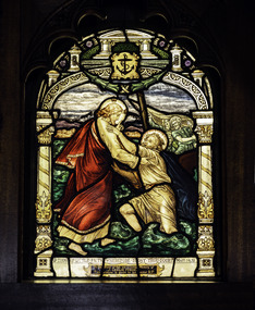
This window along with the the second window in the reredos was donated by the Misses Forge in memory of their brother, James Leslie Forge, 33yo, who died on the 23 April 1917 while working on his orchard in Wingello, NSW. A Footscray local, he had donated the funds (100 pounds) for the reredos of the St Peter chapel. Follow Me and Thou of little Faith in the Sanctuary of the Chapel were probably installed at or around the time that the building was erected. The windows are attributed to Brooks, Robinson & Co. on stylistic grounds, probably designed by William Wheildon and drawn up into a full scale cartoon by George H. Dancey c1918.Arched stained glass windows with design and texts from St. Matthew’s Gospel reference water by showing the Sea of Galilee and Christ stilling the water. The ornamental borders have the anchor of hope in the point directly central above the scene.‘Thou of little Faith Wherefore dost thou doubt’ Matt. 4.31 / To the Glory of God, and in loving memory of / J. Leslie Forge / This window is given by his sister R.F.altar, st peter chapel, flinders street, mission to seafarers, seamen's mission, mission to seamen, st peter, sailors, seamen, anchor, stained glass windows, win, 1917, ww1, memorial chapel, reredos, footscray, james leslie forge, ruby forge, forge's store, gifts-1917 -
 Mission to Seafarers Victoria
Artwork, other - Stained glass window, Brooks Robinson & Co, Follow Me, 1917
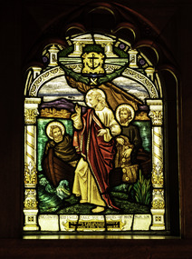
This window along with the the second window in the reredos was donated by the Misses Forge in memory of their brother, James Leslie Forge, 33yo, who died on the 23 April 1917 while working on his orchard in Wingello, NSW. A Footscray local, he had donated the funds (100 pounds) for the reredos of the St Peter chapel. Follow Me and Thou of little Faith in the Sanctuary of the Chapel were probably installed at or around the time that the building was erected. The windows are attributed to Brooks, Robinson & Co. on stylistic grounds, probably designed by William Wheildon and drawn up into a full scale cartoon by George H. Dancey c1918.Arched stained glass windows which design and texts from St. Matthew’s Gospel reference water by showing the Sea of Galilee and Christ stilling the water. The ornamental borders have the anchor of hope in the point directly central above the scene.‘Follow Me and I will make you fishers of men ‘ Matt. 4.19 / To the Glory of God, and in loving memory of J. Leslie Forge / This window is given by his sister E.F.altar, st peter chapel, flinders street, mission to seafarers, seamen's mission, mission to seamen, st peter, sailors, seamen, anchor, stained glass windows, win, 1917, ww1, memorial chapel, reredos, footscray, james leslie forge, edith forge, forge's store, gifts-1917 -
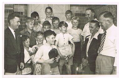 Bendigo Historical Society Inc.
Photograph - PRESENTATION OF CRICKET EQUIPMENT TO PRIMARY SCHOOL BY SANDHURST CRICKET CLUB
group photo of 11 school boys with four men, standing outside brick building, wooden door behind group. Boys in front are holding cricket pads and gloves. Written on back : 'back: Neil Button, John Turner, Maurice Grose, Centre: Lance Orchard, Graeme Moore, Merv Miles, Les Rodda, F. Stave Wallace, Ken Hartley, Paul Gill, Trevor Phillips, Bill McConnell, Noel Turner Walshy !. Presentation of cricket equipment to school by Sandhurst Cricket Club, 1951 ? On bottom LH side : V. Phillips, 274 (?9) Eaglehawk Rd. Eaglehawk.bendigo, sporting clubs, sandhurst cricket club, cricket, sandhurst, school, presentation -
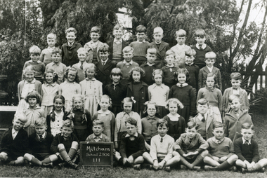 Whitehorse Historical Society Inc.
Photograph, Mitcham Primary School - Grade 3 - 1943, 1943
Black and white photograph of Students in grade 3 - Mitcham Primary School in 1943. Back Row - Robert Woolard; Neville McClean; Don Ireland; Ray Orchard; Maiford Green; Max Jones; Alan Treverton; Jim McBride. 2nd Row - Brian Bale; Gilbert Kerchevell; Graham Clements; Keith Jones; Vernon Osterlund; Andrew Stuart; Arthur Cutting; John Olson; Jack Treverton. 3rd Row - Maureen Webster; Valda Hancock; Keitha Petty; Thelma Burton; Barbara Savage; Esme Green; Barbara Woods; Irene Schafer; Peter Gorsuch. 4th Row - Margaret Bamford; Lorna Watt; Yvonne Robertson; Dorothy Summerton; Francis Ball; Patsy George; Hilton Boxshall; Alfred Gadsen.|Front Row - Andrew Bailey; Alan Baldwin; ??? Heaps; Peter Cumming; ?????; Leslie George; Les Fitzell; Ken Hennesy; Graham March.woolard, robert, mcclean, neville, ireland. don, orchard, ray, green, maiford, jones, max, mcbride, jim, treverton, alan, bale, brian, kerchevell, gilbert, clements, graham, keith, osterlund, vern, stuart, andrew, cutting, arthur, olson, john, jack, webster; maureen, hancock, valda, petty, keitha, burton, thelma, savage, barbara, esme, woods, schafer, irene, gorsuch, peter., margaret bamford;, watt, lorna, robertson, yvonne, summerton, dorothy, ball, francis, george, patsy, boxshall, hilton, gadsen, alfred, bailey, heaps, cumming, peter, leslie, fitzell, les, hennesy, ken, march, mitcham primary school no. 2904 -
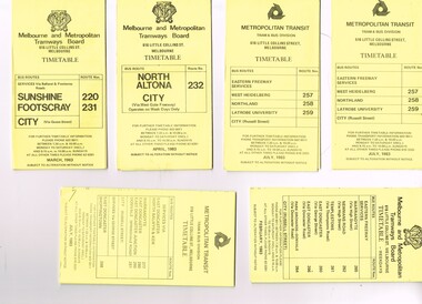 Melbourne Tram Museum
Ephemera - Timetable/s, Melbourne & Metropolitan Tramways Board (MMTB), "MMTB Bus Timetables", 1983
Timetables for specific routes, day of week giving information on tram times at specific time points, route map, sections and fares and organisation address - 616 Little Collins St. Melbourne. All printed on yellow paper unless noted otherwise. .1 - Route 220 and 231 - Sunshine - Footscray - City - March 1983 .2 - North Altona - City via West Gate Freeway - April 1983 .3 - Route 257, 258, 259 - West Heidelberg, Northland, Latrobe University - City - July 1983 .4 - ditto .5 - Route 265, 262, 261, 260, 266, 264 - Warrandyte, Templestowe, Doncaster, Park Orchard - Donvale - City - Feb. 1983 .6 - Route 277, 280, 299, 281 and 268 - Warrandyte, East Doncaster, Donvale, Shoppingtown - July 1983 .7 - Route 287, 286, 302, 303 Box Hill, Mitcham, East Doncaster, Mitcham, Ringwood - June 1980 .8 - ditto - but November 1983 .9 - Route 313, 314, 315, 316 - Warrandyte, Park Orchards, Mitcham - Jan. 1983 .10 - as for .8 11 - Routes 265, 262, 261,260, 266 and 264 - Warrandyte - Eastern Freeway, Templestowe, Park Orcards - Feb. 1983 12 - Routes 277, 280, 281 and 268 - East Doncaster, Donvale, City and Shoppingtown - Jan. 1983 Items .3, .4, .6, .8 and .10 are headed "Metropolitan Transit", rest MMTB.Yields information about MMTB Bus Services 1983Set of 12 MMTB or Metropolitan Transit Bus timetables, folded sheets, generally 10 sections.trams, tramways, mmtb, timetables, melbourne, fares, buses, deer park, sunshine, footscray, latrobe university, northland, heidelberg, box hill, warrandyte, doncaster, donvale, mitcham, ringwood, park orchards -
 Marysville & District Historical Society
Photograph (Item) - Black and white photograph, Fernshaw, c1900
An early black and white photograph taken at Fernshaw.An early black and white photograph taken at Fernshaw. Fernshaw was a rural township 63 km north-east of Melbourne and 10 km north-east of Healesville. Situated on the Watts River, near where a log had fallen making a convenient crossing, Fernshaw was settled in the 1860s. It provided good country for orchards and berry growing. The location was at the foot of Blacks Spur, with Mounts Juliet and Mondah rising on either side, providing spectacular scenery. There were nearby fern gullies giving rise to the name – ‘shaw’ is old English for thicket or wood. By 1875 Fernshaw had a post office (1865), two hotels, a school (1871) and stores. It was famed for its beauty, attracting tourists. In 1886 the Melbourne and Metropolitan Board of Works began work on the Watts River water catchment scheme – later to become Maroondah – and the Board obtained approval for the catchment country to be reserved and kept free of settlement. This required the removal of the Fernshaw township, which was completed by about 1890. The area was described in the 1903 Australian handbook:ARMSTRONG COLLECTION 42 STATION STREET/ SANDRINGHAM 3191/ TEL. (03) 9521 5442/ IAN M.L. ARMSTRONG OAMfernshaw, healesville, watts river, orchard, berry orchard, blacks spur, black spur, mount juliet, mount mondah, maroondah dam, victoria -
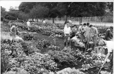 University of Melbourne, Burnley Campus Archives
Photograph - Black and white print, Publicity Branch, Department of Agriculture, Victoria, Students Weighing Produce, 1964-1965
Note by T.H. Kneen 18 December 1991, "The students are engaged in weighing produce from individual student plots. The dark haired female student is Lauris (or Loris) Inglis a 1966 graduate. Plots were a feature of the second year therefore the photo is probably 1965."Black and white photograph. Group of students working in the vegetable plots and bringing their produce to be weighed. One student spraying his crops. Yarra Boulevard in the background. On reverse stamp, "Photograph by Publicity Branch Victorian Department Of Agriculture Ref. No. D521F".students, female students, lauris inglis, loris inglis, weighing produce, orchard, students working outside, vegetable plots, spraying, yarra boulevard, publicity