Showing 123777 items matching "main-road"
-
 Lakes Entrance Historical Society
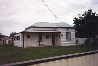
Photograph - Historic House, 2000
Owner Keith Bryce? Let as holiday accommodation.|Also one other colour photograph similar view, taken from street shows house behind solid fence, tall trees at side.Colour photograph of a timber dwelling at 40 Roadknight Street, with corrugated iron hipped roof. Three entries from front veranda, one to enclosed side veranda, a main entry, and third into extension beside main entry. Mix of door and window styles reflects DIY additions. Lakes Entrance Victoriahouses, heritage study -
 Ballarat Tramway Museum
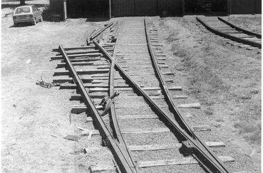
Photograph - Black & White Photograph/s, Dave Macartney, 8/02/1985 12:00:00 AM
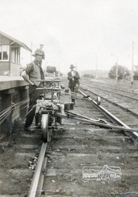
Has a strong association with the completion of the track fan at the BTPS depot during 1985 and yields information about the method of construction.Black and White photograph of the construction of No. 7 road at the BTPS Depot, 8/2/1985. shows the points installed and some rail laid out pending bending. Photographed by Dave MacartneyOn rear in ink "No. 7 road takes shape. Within three weeks, the track was complete to the back wall of the shed, lifted and packed in use. Label "Photo Page 34 top Reduce to 5 1/2" x 2 7/8". and in bottom left hand corner "Photo Dave Macartney" See April 1985 Trolley Wiretramways, trams, btps, trackwork, track laying -
 Melbourne Tram Museum
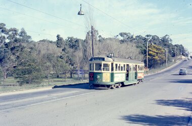
Photograph - Four colour slides - Wattle Park Single Line, Warren Doubleday, 1-8-1970
Set of four photographs taken at the time of the conversion of the Wattle Park route, in Riversdale Road from single line to double track between Warragul Road and the terminus, alongside Wattle Park itself. Yields information on the single line operation of the Wattle Park line prior the conversion to double track operation.Set of four colour Anscochrome slides, of single line operations on the Wattle Park line. .1 - W5 722 on Wattle Park single line, Sat. p.m. .2 - W2 388 meets W2 344 on Wattle park loop - shows the commencement of roadworks. .3 - SW5 853 from the park .4 - W5 738 at Warragul Road - shows the gates to Wattle park and the Caltex Service Station sign.Has photographers slide numbers on each slide.wattle park, route 70, riversdale rd, w2 class, w5 class, sw5 class, trackwork, tram 722, tram 388, tram 853, tram 738, trams, tramways -
 Eltham District Historical Society Inc
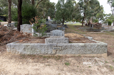
Photograph, Peter Pidgeon, Grave of William Hill and Agnes Somerville Irvine and family, Eltham Cemetery, Victoria, 5 April 2021
William Hill Irvine was born 6 July, 1858 in Newry, County Down, Ireland. He arrived in Melbourne December 1879 and taught at Geelong College. He was admitted to the Supreme Court in 1884 having qualified from Melbourne University and practiced in Melbourne. In 1891 he married Agnes Somerville Wanliss and they had one son, William Mitchell (1901 Armadale) and two daughters, Beatrice Wanliss (1899 Armadale) and Agnes Somerville Wanliss (1903 Armadale). Sir William Irvine sat in the Victorian Parliament (as Liberal Member for Lowan) from 1894 to 1906 and was Premier of Victoria from 1902 to 1904. He then switched to Federal politics and sat in the Commonwealth Parliament (as Liberal Member for Flinders) from 1906 to 1918. He was considered a potential Prime Minister, but his abrupt manner and hard-line conservatism (particularly his attitude to a railway strike) made him unacceptable even to many Liberals: he was known in Parliament as "Iceberg Irvine". He lived at Richmond, but in 1908 purchased land in Laughing Waters Road at Eltham, where he built the house ‘Killeavey’, initially as a weekend retreat. The site, a peninsula surrounded on three sides by the Yarra River, is of geological importance and has considerable cultural significance to the Wurundjeri. In 1912 Sir William moved to Killeavey and in 1913 purchased more land, extending his property to Reynolds Road. In 1923 he shifted to Toorak, donating Killeavey to his daughter Beatrice as a wedding gift. Sir William was a founding member of the RACV and was Acting Governor of Victoria from 1931 to 1934. He was also a notable public figure involved in several local events including the: 1919 Unveiling of Eltham War Obelisk 1921 Eltham Primary School Extensions 1921 Eltham Primary School Roll of Honour of prior students 1928 Opening of Eltham Higher Elementary School 1926 Unveiling the Shire of Eltham War Memorial in Memorial Park at Kangaroo Ground He died in 1943 and is buried in Eltham Cemetery with his wife Agnes along with son William Mitchell Irvine and his wife, Dora Haswell Sacred to the memory of William Hill Irvine G.C.M.G. Lieutenant Governor And Chief Justice of Victoria Born 6th July 1858 At Newry, Northern Ireland Died 20th August 1943 Also his wife Agnes Somerville Born at Ballarat 16th Nov 1867 Died at Eltham 16th Aug 1954 W. M. W. Irvine 1901-1975 And Dora Haswell Wife of W. M. W. Irvine 1900-1979Born Digitaleltham cemetery, gravestones, agnes sommerville irvine (nee wanliss), dora haswell irvine, william hill irvine, william mitchell irvine -
 Whitehorse Historical Society Inc.
Photograph, Matheson's Home
The Nunawading orchard was purchased in 1920 by Mary Lilian Matheson from Florence Rebecca Course for a sum of 1050 Sterling Pound. In 1988 the Federal & State government allocated $125,000 to the Nunawading Council towards the purchase of the house, outbuildings and the orchard facing Springvale Road, as it was representative of one of the last working orchards in the Nunawading district. The property has now been vacant for many years (2011) and is secured with window bars and security services. Lately a large cyprus tree crashed onto the largest outbuilding and it was removed.8 coloured photographs (a-h) of the Matheson house and orchard on Springvale Road, East Burwood. House, shed, windmill, old orchard and pine and cyprus in the photographs.matheson, mary, matheson orchard, orchards, early burwood, strathdon -
 Phillip Island and District Historical Society Inc.
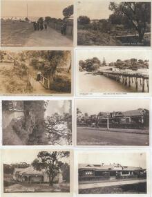
Photograph - Post Cards, Rose Series, Early 20th Century
One of 15 A3 sheets with copies of postcards on each page. Shirley Jones Collection.Copies of postcards: Left side from top to bottom: 1. A group of people walking down Cowes Main Street. 2. Lovers Walk Cowes. 3. Lovers Walk Cowes. 4. Clovelly Guest House Cowes. Right side from top to bottom: 1. Lovers Walk Cowes. 2. Looking towards Cowes from the Pier. 3 & 4. The Continental Guest House Cowes.Left side from top to bottom: 1. "Main St Cowes" 2. "The rose Series P653 - The Lovers Walk Cowes Phillip Is Victoria". 4. "No 107 'Clovelly' Cowes". Right side from top to bottom: 1. "Lovers Walk Cowes". 2. "The Rose Series P657 - Cowes from the Pier Phillip is Victoria". 3. "The Continental Cowes Phillip Island V8" 4. "No 149 the Continental Cowes".lovers walk cowes, main street cowes phillip island, clovelly guest house cowes, guesthouses, cowes pier phillip island, the continental guesthouse, shirley jones collection, thelma astbury -
 Eltham District Historical Society Inc
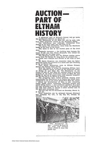
Document - News Clipping, Auction - Part of Eltham history
Copy of undated article headed "Auction part of Eltham history" regarding sale of property at 816 Main Road, Eltham (In March 2020 the site of Goodstart Early Learning Eltham) on the corner of John Street owned by the Burgoyne Family.1 page A4 photocopyHG Booklet 37816 main road, burgoyne, h. burgoyne, harry burgoyne, harry gilham collection, hawthorns, john james thomas neville burgoyne -
 Eltham District Historical Society Inc
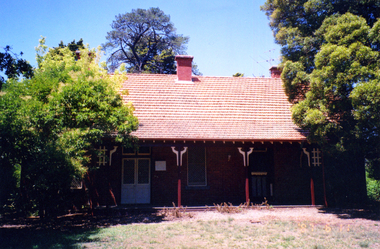
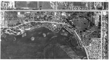
Slide, Construction of Eltham Town Park, 25 Jul 1973
Construction of Eltham Town Park; landscape has been scupltured and lakes formed. Shillinglaw Cottage , Main Road, Eltham Shire Council Offices and Catholic Church all visible. The park was later renamed Alistair Knox Park.35 mm colour positive transparency Mount - Agfacolor Service (Blue)Memorial Park 25 July 1973eltham, main road, alistair knox park, eltham town park, shillinglaw cottage, bridge street -
 Greensborough Historical Society
Photograph - Digital image, Caroline and Ferdinand Barnett and sister, 1940c
Caroline and Ferdinand Barnett and his sister Emily Barnett from Northcote. Taken at 122 Main Road Lower Plenty. Photographs from the collection of Peter Blackbourn, a descendant of the Chapman Stock family. Annotations to photos by Peter Blackbourn.Digital copy of black and white photograph.peter blackbourn, caroline barnett, ferdinand barnett, emily barnett, 122 main road lower plenty -
 Eltham District Historical Society Inc
Photograph, Jim Jenkins, probably at Eltham Railway Station
Jim Jenkins worked for the Railways and lived in York Street (Source: Electoral Rolls) Pages from a scrapbook belonging to Heather Jenkins (nee Sargeant) who lived as a child in the Police Residence at 728 Main Road, Eltham in the 1920s.Heather Sargeant was the daughter of Constable W.C. Sargeant, the local police officer in residence at Eltham, 1922-1927Glued on a brown paper scrapbook page (torn from scrapbook) with 9 black and white/sepia photos of varying sizes, 1 newspaper clipping and handwritten captions in ink.On verso in pencil "Const. W.C. Sargeant 1922-1927 - see Police list"heather jenkins (nee sargeant), eltham, police residence, constable w.c. sargeant, jim jenkins, eltham railway station, railway line -
 Eltham District Historical Society Inc
Photograph postcard, Nearing the Station; postcard from Emily for Christmas
View looking north along Main Road from Bridge Street to York Street. Shillinglaw Cottage and the Shillinglaw trees are visible in the centre distance. Possibly Sunday sightseers who have come out on the train from Melbourne. Digital file only Postcards scanned from the collection of Michael Aitken on loan to EDHS, 13 Feb 2018michael aitken collection, postcards, eltham, main road, shillinglaw cottage, shillinglaw trees, york street, bakery -
 Sunbury Family History and Heritage Society Inc.
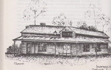
Artwork, other, Ian Symonds, Inverness Hotel
The building is a black and white drawing by Ian Symonds of the former Inverness Hotel, which was sited at the intersection of the Old Bulla and Oaklands Roads. The hotel was demolished when the land was included in the boundary of Melbourne Airport and is now part of the main runway.The Inverness Hotel was open of the first hotels be built along the Bulla Road. A photograph of a black and white drawing of an old hotel buildingI. Symondsinverness hotel, ian symonds, melbourne airport, hotels -
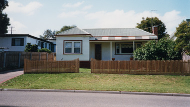 Lakes Entrance Historical Society
Photograph - Historic House, 2000
Part of a larger dwelling originally situated 607 Esplanade, (now site of Golden Beach Motel), other half moved to Lake Tyers Beach Road. This section moved to present site around 1965 by Ray Curry. Various residents Misses Phillips (original site) George Ward, R A and K D Bills from 1993.Colour photograph of a weatherboard dwelling with hip roof situated at 15 Coates Road. Has a bull nose veranda across front entry, oiled timber picket fence. Lakes Entrance Victoriahouses, fences, heritage study -
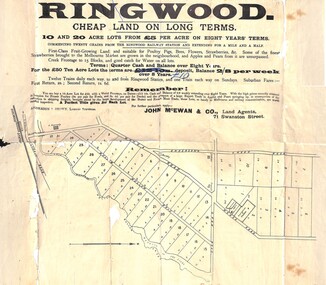 Ringwood and District Historical Society
Flyer, Land Sale Advertisement, Ringwood, Victoria - 1894
Land sale advertisement for 10 and 20 acre lots from £5 per acre on eight years' terms in Ringwood, with description of local facilities and agricultural features.Subdivision map includes Mullum Mullum Road, Wonga Road, Oban Road and Anderson's Creek Road (later Warrandyte Road). Markings on reverse side indicate the sheet was sent by post from John McEwan & Co., Auctioneers, Land Agents & Business Brokers, 71 Swanston Street, Melbourne, to Mr Allan, Builder, Ringwood, postmarked in JE (June), 1894. -
 Whitehorse Historical Society Inc.
Article, Inspired to write, 2001
Article on four women from Whitehorse who will share their life stories in an exhibition at the Museum of Victoria.Article on four women from Whitehorse who will share their life stories in an exhibition at the Museum of Victoria, Valda Arrowsmith, former Nunawading Mayor, Mary Ryan, former Box Hill mayor, Helen Trotter, Carrington Road Seniors Club advocate and Councillor Kaele Way.Article on four women from Whitehorse who will share their life stories in an exhibition at the Museum of Victoria. women, community services, arrowsmith, valda, ryan, mary, trotter, helen, way, kaele -
Glen Eira Historical Society
Book - Hillcrest Estate Draft Heritage Guidelines July 2000
2 items about Hillcrest Estate and heritage: 1/A 20 page report giving draft heritage guidelines by the City of Glen Eira for properties within the Hillcrest Estate Heritage Area of Caulfield South, including Hillcrest Avenue numbers 1 and 3-12 and Marara Road numbers 27 and 28. The Heritage Area has been assessed as noteworthy as 'the first housing estate developed by the AV Jennings Construction Co., later known as Jennings Group Limited.' Developed during the Depression years of the early 1930s, it is considered an 'unusually intact example of an interwar garden estate' and is also considered noteworthy for its aesthetic values. The Report describes typical features for two house forms typical of the area: the single-storey villa with decorative porch and the single storey villa with decorative verandah. It gives guidelines on the types of changes which can be made to houses within the Heritage Area. Included are photographs of typical houses and design features, maps, and diagrams showing acceptable zones for additions, amongst other Sections (eg. Key design checklist). 2/A three page photocopy taken from Andrew Ward's Heritage Study for The Hillcrest Estate Historic Area.hillcrest estate, glen eira heritage management plan, glen eira planning scheme, glen eira city council, hillcrest estate heritage area, hillcrest avenue, merri street, marara road, eumerella street, av jennings construction co, jennings group limited, caulfield south, jennings albert, brick houses, architectural styles, architectural features, housing estates, garden estate, heritage studies, glen eira city council, city of glen eira, draft heritage guidelines july 2000, glen huntly, vines william, gurney edward, eumeralla street, 'karkill', house names, cropmpton court, booran road, estate agents -
 Wangaratta RSL Sub Branch
Mixed media - Framed Map and Newspaper, Peter Muncey, 23/7/1943
Sketch Map of Bulldog-Wau Road New Guinea drawn to scale by 2/1 Aust Fd Coy dated 23.7.43 and signed by soldiers together with related newspaper article. Hand sketched by Peter Muncey VX10042 a Draughtsman who served in the Middle East Ceylon and New Guinea with the 2/2 and 2/1 Field Coy Royal Australian Engineers. The sketch contains 26 signatures including:- S/Sgt Raymond Hector Ibbotson NX14112 who served in the Middle East and New Guinea Lt Col Jack Graham Wilson NX 130646Bulldog Track also known as Bulldog-Wau road was longer, higher, steeper, wetter, colder and rougher than Kokoda Track. In 1943 Australian Army engineers; the 2/1 and 2/16 Field Company RAE, 9th Australian Field Company (AIF), veterans of Syria, Palestine, Egypt, Greece and Crete, the 1st and 3rd Australian Pack Transport Companies and local Papuan labour cut the road with pickaxes and dynamite over a period of eight months. During five months of operations over seventy per cent of the 2/1 Australian Field Company contracted malaria.Seventeen bridges were constructed; mostly single, but at least one with multiple spans. More than two thousand Australian army personnel and over two thousand Papuans and New Guineans were involved during nine months of construction. Thus the road, acclaimed as the greatest military engineering feat ever, was completed and for the only time in history motor vehicles crossed the high rugged mountains of Papua New Guinea. Carved brown timber frame with cream mount containing hand sketched map with soldiers signatures and two newspaper articles.Sketch Map of Bulldog-Wau Road 23.7.43 2/1 Aust Fd Coy Newspaper - Diggers pushed on with pick and shovelbulldog-wau road, map, new guinea, ww2, 2/1 aust field coy -
 St Kilda Historical Society
Photograph, St Kilda Junction with Old Police Paddock, c. 1858
on back: St Kilda Junction showing old police paddock and canoe tree? Date unknown, but before bitumen surfacing of roads -- pre 1900? Copy courtesy LaTrobe Library, Melbourne Handwritten: about 1858copy of(?) black and white photograph fair condition unmountedSt Kilda Junction showing old police paddock and canoe tree? Date unknown, but before bitumen surfacing of roads -- pre 1900? Copy courtesy LaTrobe Library, Melbourne Handwritten: about 1858 -
 Eltham District Historical Society Inc
Photograph, Peter Pidgeon, Memorial to Gordon Craig Ford, Landscape Designer, Eltham Cemetery, Victoria, 5 April 2021
Gordon Ford was a conservationist and a pioneer of natural-style landscaping. He came to Eltham in 1948 and bought a block of land in John Street extending through to Pitt Street. Artist Peter Glass lived opposite in John Street. Early on, Gordon worked for Alistair Knox on construction of the mudbrick Busst house amongst others. At the same time, with the help of friends including artist Clifton Pugh, he progressively built his own house ‘Fülling’, which "grew like Topsy" utilising a variety of second-hand materials. His main focus, which became his life-long occupation, was garden landscaping. Inspired by Edna Walling and Ellis Stones, he sought to reflect the bush settings of rural Victoria where he had grown up. Commissions included Monash University and countless industrial sites but designing for the archetypal quarter-acre block gave him the most satisfaction. He had a huge impact on the look of gardens in Australia from the 1950s, creating seemingly natural bush environments by carefully integrating indigenous and exotic plantings. Gordon died in 1999 and is buried in Eltham Cemetery; the gravesite is marked by a plaque. Another plaque (away from his grave) notes his landscaping design work within the cemetery grounds and at Alistair Knox Park. Gordon Craig Ford Landscape Designer 30. 8 .1918 - 16. 6. 1999 Eltham Cemetery Trustee fom 1987 - 1999 Gordon settled in Eltham in 1948 He was a conservationist and a pioneer of natural style landscaping, continuing design and construction until his death. His local work and influence can be seen in many private gardens, the Eltham Cemetery and the Alistair Knox Park.Born Digitaleltham cemetery, gravestones, gordon craig ford -
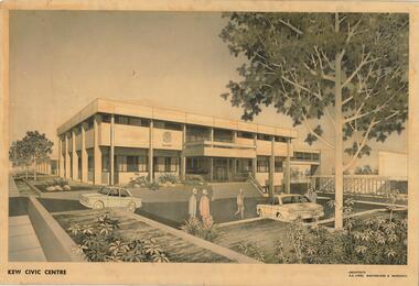 Kew Historical Society Inc
Drawing, AK Lines, Macfarlane & Marshall, Kew Civic Centre, c.1970
The Kew Civic Centre (A K Lines, MacFarlane & Marshall, 1972) was built next to the Kew Civic Hall (A C Leith & Bartlett, 1960) on the site of the former mansion Ordsall (later renamed South Esk). Whereas the entrance to the Civic Hall was positioned off Civic Drive, the main entrance to the Civic Centre faced Cotham Road, as shown in the undated perspective drawing of the proposed building. The Civic Hall was used for public functions and performances, while the Civic Centre was used for civic offices. It also contained the Council Chamber. The building opened in 1972, following the relocation of the councillors and council officers from the former Town Hall in Walpole Street (now a Woolworth's supermarket). Following the amalgamation of the former City of Kew into the City of Boroondara in 1994, the Civic Centre was sold to Trinity Grammar School. The exterior of the Centre has been modified by Trinity Grammar.A report for Heritage Victoria (date) describes how two architectural firms dominated the designs for new civic buildings in Victoria during the post war period. The report claims that: "An interesting sub-theme in the erection of post-war municipal offices in Victoria is that a considerable proportion were designed by the same three or four Melbourne-based architectural firms, who established themselves as the leading specialists in this type of work. The two most prolific firms in this regard were A K Lines, MacFarlane & Marshall, and A C Leith & Bartlett; both, in fact, had made names for themselves as designers of local government offices prior to the Second World War. Lines' office, for example had designed the Eltham Shire Offices in 1941, while Leith's firm had been responsible for the celebrated Heidelberg Town Hall in 1937). Both practices parleyed this early experience into a lucrative post-war career, designing numerous municipals offices well into the 1970s." (Survey of Post-War Built Heritage in Victoria, Built Heritage Pty Ltd, 2010.) The perspective drawing importantly captures the original design and function of the exterior of the building and its public entrance.Hand-coloured perspective sketch of the new Kew Civic Centre, completed in 1972 to designs by A K Lines, MacFarlane & Marshall; and located on the corner of Charles Street and Cotham Road, Kew. The sketch represents the front elevation of the building and its relation to the preexisting Kew Civic Hall at right. The three storey building features strong vertical concrete buttresses that extend across the three levels. KEW CIVIC CENTRE / A K LINES, MACFARLANE & MARSHALLkew civic centre, a.k. lines, macfarlane & marshall, architectural drawings, civic buildings -- kew (vic.), town hall -- kew (vic) -
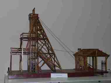 Federation University Historical Collection
Unknown - Model, Poppet Head Model
This scale model of a mining plant was made by Donald Douglas Mather of Talbot. The engine shed houses the winches, which raise and lower the cages carrying the workmen. The winches also control the water-Baling tanks, which are lowered into the pump shaft to clean the water. The Pump Shaft is part of the main shaft partitioned off for keeping the water down. The old style plant (or cas commonly known poppet legs), were all of timber construction and, when erected, straddled the main shaft. This scale model allows for steel construction, and is set over the shaft to permit an unobstructed view of the operations. The Bad level is where the workmen enter and leave the shaft. The staging platform on the first level is where the trucks and mullock or other material are wheeled out on rails and then tipped to form the mine dump. The top level is to allow for maintenance of plant. Donald Douglas Mather of Talbot worked in mines in Ballarat, and made the model of the poppet head. The poppet head is a replica of those used at many mines in Ballarat. Back in the 1850s Ballarat was a god rush town and many mining claims were made and poppet heads built this is a replica of those poppet heads which are a part of Ballarat's Heritage and a full size poppet head is erected at Sovereign Hill Theme Park in Ballarat. Mining is a huge part of Ballarat's history.A timber poppet head and engine room model. "This scale model - the modern construction of a mining plant - was made by Mr Donald Douglas Mather* of Bonnie Doon, Talbot, Victoria. The engine shed houses the winches, which raise and lower the cages carrying the workmen. The winches also control the water-baling tanks, which are lowered into the pump shaft to clean the water. The pump shaft is part of the main shaft partitioned off for keeping the water down. The old style plant (or as commonly known poppet legs), were all of timber construction and, when erected, straddled the main shaft. this scale model allows for steel construction, ans is set over the shaft to permit an unobstructed view of the operations. The bad level is where the workmen enter and leave the shaft. The staging platform on the first level is where trucks ad mullock or other material are wheeled out on rails and then tipped to form the mine dump. The top level is to allow for maintenance of plant. * Mr Mater, previously of Ballarat, worked for many years as a miner and plant erector" (Old interpretive panel)mining, mather, mining plant, poppet head, engine house, model, donald douglas mather -
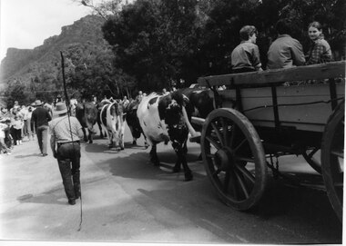 Halls Gap & Grampians Historical Society
Photograph - B/W, Oct-86
The bullock team was part of a parade held on the main street of Halls Gap in conjunction with the 150th anniversary of Major Mitchell's visit to the area. There was also a plaque unveiled in commemoration of the Wildflower Show and its many volunteers.The photo is taken from the rear of a bullock team pulling a dray down a road. Three children can be seen sitting in the dray and its back is out of shot. Two men are walking to the left of the team, the closest to the camera holding a long whip over his shoulder. To the far left people can be seen lining the street and in the right background a range of peaks can be seen.events, parades -
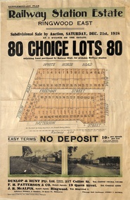 Ringwood and District Historical Society
Flyer, Subdivisional Auction Sale Brochure, Railway Station Estate, Ringwood East, Vic. - 1918
Advertisement for subdivisional auction sale of 80 residential allotments on Saturday, 21st December, 1918, including terms of sale, subdivision layout, and nearby location photographs.Subdivision includes Mount Dandenong Road (incorrectly shown as White Horse Road), Dublin Road, Freeman Street, Bona Street, and Patterson Street. Local Agent - J.B. McAlpin, Telephone Ringwood 7. -
 Ballarat Tramway Museum
Photograph - Black & White Photograph/s, early 1980's
Yields information about the Gardens area of Ballarat during the early 1980's.Black and white aerial photograph of the Botanic Gardens and Lake Wendouree adjacent to the Gardens area during the early 1980's. Shows the BTPS depot with 4 and 5 roads track built, but not that of 6 and 7 road. No. 1 road still in position. No. 6 road installed during the 1983-84 year. See 1983-84 Annual Report for construction of 6 road.On rear in pencil "3594/159"trams, tramways, botanical gardens, wendouree parade, lake wendouree, btps depot -
Whitehorse Historical Society Inc.
Leisure object - Land Title, Moffatt land, 1907
Certificate of Title Vol. 3247 Fol. 346.Certificate of Title Vol. 3247 Fol. 346, 9 acres, 25 perches, Mahonys Road Burwood, 19 November 1907. Incl. transfers to MMBW 4 August 1926 and Arthur Vernon Moffatt 30 October 1934 by William James MoffattCertificate of Title Vol. 3247 Fol. 346.moffatt, arthur vernon, melbourne and metropolitan board of works, moffatt, william james, mahoneys road burwood east -
 Surrey Hills Historical Society Collection
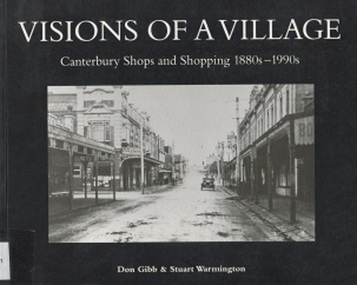
Book, Visions of a Village : Canterbury shops and shopping 1880s-1990s, 1995
Focussing on the growth and activities that took place in the shopping and service centre of Canterbury and Maling Roads in Canterbury from the 1880s to the present, it is partly a guide book to the present buildings of the centre through the streetscapes and brief lives of each of the premises.Focussing on the growth and activities that took place in the shopping and service centre of Canterbury and Maling Roads in Canterbury from the 1880s to the present, it is partly a guide book to the present buildings of the centre through the streetscapes and brief lives of each of the premises. illus. of streetscapes, indexshops, canterbury, maling road, (mr) george robinson, rochester road, j weymouth, railways, m white, hindson buildings, (mrs) - hillier, f g wilson, s huckerby, g cox, (mr) george cornell, lawson brothers, retail trade, commercial development -
 Surrey Hills Historical Society Collection
Book, Visions of a Village : Canterbury shops and shopping 1880s-1990s, 1995
Focussing on the growth and activities that took place in the shopping and service centre of Canterbury and Maling Roads in Canterbury from the 1880s to the present, it is partly a guide book to the present buildings of the centre through the streetscapes and brief lives of each of the premises.Focussing on the growth and activities that took place in the shopping and service centre of Canterbury and Maling Roads in Canterbury from the 1880s to the present, it is partly a guide book to the present buildings of the centre through the streetscapes and brief lives of each of the premises. illus. of streetscapes, indexshops, canterbury, maling road, (mr) george robinson, rochester road, j weymouth, railways, m white, hindson buildings, (mrs) - hillier, f g wilson, s huckerby, g cox, (mr) george cornell, lawson brothers, retail trade, commercial development -
Glenelg Shire Council Cultural Collection
Photograph - Photograph - Dutton Way, 1976
Port of Portland Authority ArchivesBack: Dutton Way - pencil, lines leading to grey stamp. Location Date 30.6.76 - blue biro Time Reference 74/15 - blue biro -
Whitehorse Historical Society Inc.
Map, City of Whitehorse, 1/03/1995 12:00:00 AM
Map showing streets of the City of Whitehorse from Mullum Mullum Creek to the north to Highbury Road and Warrigal Road in the west, to Heatherdale Road in the east.Map showing streets of the City of Whitehorse from Mullum Mullum Creek to the north to Highbury Road and Warrigal Road in the west, to Heatherdale Road in the east. Prep. by Richard Meloni. Scale 1:15,000Map showing streets of the City of Whitehorse from Mullum Mullum Creek to the north to Highbury Road and Warrigal Road in the west, to Heatherdale Road in the east. city of whitehorse, mullum mullum creek -
 Whitehorse Historical Society Inc.
Photograph, Narmara Primary School, 13/01/1994 12:00:00 AM
Coloured photo of Narmara Primary School, Namara Street, looking North. School on North side of Highbury Road, between Middleborough Road and Blackburn Road. Since demolished and site developed for housing.narmara primary school, warner, philip