Showing 1356 items matching " a urban"
-
 Federation University Art Collection
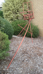
Sculpture - Artwork, 'Urban' by Neale McSwain, 1986
Neale McSWAIN Neale McSwain was a student at the Ballarat College of Advanced Education (now Federation University) in 1986. The art acquisition prize for student work was awarded to Neale McSwain in 1986. This is the first time that the award was made for a sculpture. This item is part of the Federation University Art Collection. The Art Collection features over 1000 works and was listed as a 'Ballarat Treasure' in 2007.Tall, red, steel sculpture. art, artwork, neale mcswain, mcswain, sculpture, ballarat college of advanced education, alumni -
 Federation University Art Collection
Drawing, Bradley, Tobias, 'Urban Saint' by Tobias Bradley, 2000 c
This item is part of the Federation University Art Collection. The Art Collection features over 1000 works and was listed as a 'Ballarat Treasure' in 2007.art, artwork, drawing, student art show, alumni -
University of Melbourne, Burnley Campus Archives
Document - Course Information, The University of Melbourne et al, Australian School of Urban Forestry, 2018
professional development forestry, urban forestry, course -
University of Melbourne, Burnley Campus Archives
Pamphlet - Symposium, Melbourne School of Land and Environment, Symposia on Contemporary Issues in Urban Landscapes, April 2013
horticulture, 150th celebrations, burnley gardens -
Tarnagulla History Archive
Booklet: Tarnagulla Urban Fire Brigade, 125 Years of Service to the Community, 1994
David Gordon Collection. -
Tarnagulla History Archive
Tarnagulla Urban Fire Brigade uniform patch
David Gordon Collection. -
Canterbury History Group
Document - Lowell Chen, Urban Planning Special Committee - City of Boroondara, 1/12/2011 12:00:00 AM
Kew and Hawthorn. Further Heritage Investigations. Attachments for item: UPC3. Individual Heritage Overlays: Authorisation and Exhibition of Planning Scheme Amendment. Summary Report Prepared for the City of Boroondara. Item 3 Emulation Hall, Canterbury. pages 174-177. Includes black and white photographscanterbury, rochester road, dunstan reynolds & partners, egyptian revival style, emulation hall, historic buildings, masonic lodges -
 Melton City Libraries
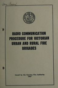
Booklet, Radio Communication procedure for Victorian Urban and Rural Fire Brigades, 1967
TRANSCRIPTION - Region 14 Mount Cotterill Fire Brigades Group final radio schedule Sunday 26/11/78 Last regular sched as GO Thanks to all Brigades and Members and will carry on communications and GO taking over. thanks on behalf of Ed and I over the years Thanks from LY 1 Good job LY 23 Good job over the years LY 33 ????? LY 43 Thanks for making ? LY 45 Trug [anina] for all work done and looking to assist in future Group No first for Tel LY 48 Thanks job well done LY 51 From officers and fireman add congrat to job well done, both you and your wife. LY 51 Rene Thanks for assist to me by you and Mrs Barrie LY Rem Thanks and look for help when roles are reversed. LY/OX G Morn to Group Freda and I and BM Group and sad. I too approach with mixed feelings / radios beginning in the 50’s too long to remember LY/OX I took clues from transmissions. Fires along the rail line OX and LY and RC From all Hand written notes by Edna Barrie during transmission of last radio schedule of Group Communications Officer Mt Cotterill Fire Brigade Group taken by EW (Bon) Barrie from Headquarters at 19 First Avenue Melton South. 1967 – 1978.Edna Barrie's copy of the procedure booklet, issued by Country Fire Authority emergency services -
Canterbury History Group
Letter - Letter to Mr. Henry Okraglik from City of Camberwell, 1991, 25/02/1991 12:00:00 AM
Letter to the Historic Buildings Council from Brian Jones CEO of City of Camberwell with a submission that 208 Canterbury Road Canterbury be included onto the Historic Buildings Council.canterbury, canterbury mansions, canterbury road, historic buildings register, okraglik> henry, city of boroondara, urban conservation business zone -
Canterbury History Group
Document - Draft citation from the National Trust of Australia (Victoria), 4/03/1991 12:00:00 AM
Submission to the Historic Buildings Council from the National Trust of Australia (Victoria) citing Canterbury Mansions as being sufficiently of both architectural and historical importance to warrant its inclusion on the Register of Historic Buildings, with a covering letter.canterbury, canterbury mansions, canterbury road, national trust of australia (victoria), register of historic buildings, canterbury shopping centre environs urban renewal guidelines, butler> graeme, okraglik> henry -
 Wodonga & District Historical Society Inc
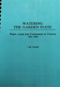
Book - Watering the Garden State - Water, Land and Community in Victoria 1834-1988, J.M. Powell
This publication traces the importance of water resources to Australian society, with reference to the state of Victoria. It relates the history from 1834 including topics such as community adaptation to settlement planning for squatters, miners, immigrants and colonials; conservation and water management; expansion and consolidation of statutory bodies following the creation of the Department of Water Resources in 1984; and finally the effects of regionalism, environmentalism, urban conflict and institutional reform. It includes an appendix containing a brief chronology of significant events regarding water from 1853 to 1987.Spiral bound booklet with laminated covernon-fiction This publication traces the importance of water resources to Australian society, with reference to the state of Victoria. It relates the history from 1834 including topics such as community adaptation to settlement planning for squatters, miners, immigrants and colonials; conservation and water management; expansion and consolidation of statutory bodies following the creation of the Department of Water Resources in 1984; and finally the effects of regionalism, environmentalism, urban conflict and institutional reform. It includes an appendix containing a brief chronology of significant events regarding water from 1853 to 1987.water resources development, water-supply -- victoria -- history., water victoria -
 Wodonga & District Historical Society Inc
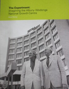
Booklet - THE EXPERIMENT : Imagining the Albury - Wodonga National Growth Centre, Bruce J Pennay, 2013
Introductory Abstract - "On its instigation in 1973, the Albury-Wodonga Growth Centre experiment was hailed as a novel and imaginative project. It was a "pilot scheme" that was expected to influence the urban settlement pattern in Australia. It was a "bold venture", a "brave attempt" to solve a longstanding problem. It involved three governments embarking on an "exciting adventure". This short book length catalogue essay (51 pages) provides an illustrated guide to the social history and visual arts exhibitions mounted for the 40th anniversary in 2013 of the inauguration of the Albury-Wodonga National Growth Centre experiment. The essay served as rationale and support for two council exhibitions at the Albury Library Museum and the Arts Space Wodonga in October and November 2013. The background story and the exhibitions are about place-making. They ask about the kind of place that has been made at Albury-Wodonga. How was it imagined, promoted, grown? They examine the experiment of developing Albury and Wodonga jointly and rapidly, and ask how that experiment relates to the place now and in the future. It assesses and gives a broad contextual account of the National Growth Centre experiment at Albury-Wodonga and traces important aspects of the story with emphasis on a local point of view. " Bruce Pennaynon-fictionIntroductory Abstract - "On its instigation in 1973, the Albury-Wodonga Growth Centre experiment was hailed as a novel and imaginative project. It was a "pilot scheme" that was expected to influence the urban settlement pattern in Australia. It was a "bold venture", a "brave attempt" to solve a longstanding problem. It involved three governments embarking on an "exciting adventure". This short book length catalogue essay (51 pages) provides an illustrated guide to the social history and visual arts exhibitions mounted for the 40th anniversary in 2013 of the inauguration of the Albury-Wodonga National Growth Centre experiment. The essay served as rationale and support for two council exhibitions at the Albury Library Museum and the Arts Space Wodonga in October and November 2013. The background story and the exhibitions are about place-making. They ask about the kind of place that has been made at Albury-Wodonga. How was it imagined, promoted, grown? They examine the experiment of developing Albury and Wodonga jointly and rapidly, and ask how that experiment relates to the place now and in the future. It assesses and gives a broad contextual account of the National Growth Centre experiment at Albury-Wodonga and traces important aspects of the story with emphasis on a local point of view. " Bruce Pennayalbury-wodonga, decentralisation, urban settlement australoa -
 Wodonga & District Historical Society Inc
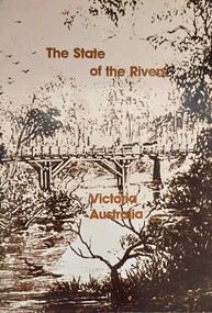
Book - The State of the Rivers, Victoria Australia, Constable, D & Smith, K, 1983
Rivers play an essential part in the life and wealth of our society. They are also the most striking feature of the landscape, contributing much to the beauty of rural and urban surroundings as well as to the recreation, peace and happiness of our people. This report includes historical colour and black and white photos and maps. It aimed to give an accurate account of the condition of the rivers of Victoria. It was produced by the Standing Consultative Committee on River Improvement.A 64 page volume including text, black and white and colour images and maps.Rivers play an essential part in the life and wealth of our society. They are also the most striking feature of the landscape, contributing much to the beauty of rural and urban surroundings as well as to the recreation, peace and happiness of our people. This report includes historical colour and black and white photos and maps. It aimed to give an accurate account of the condition of the rivers of Victoria. It was produced by the Standing Consultative Committee on River Improvement.rivers in victoria, conservation victoria, water supply victoria -
 Wodonga & District Historical Society Inc
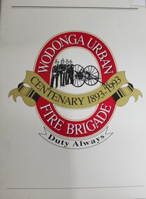
Book - Wodonga Urban Fire Brigade Centenary 1893- 1993, Country Fire Authority Victoria, C. 1993
The Wodonga Fire Brigade was founded in 1893 from a need to protect life and property in what was a small town straddling the Melbourne-Sydney railway line. This book traces the first 100 years of its development and service to the community.The Wodonga Fire Brigade was founded in 1893 from a need to protect life and property in what was a small town straddling the Melbourne-Sydney railway line. This book traces the first 100 years of its development and service to the community.history wodonga urban fire brigade, cfa wodonga -
 City of Kingston
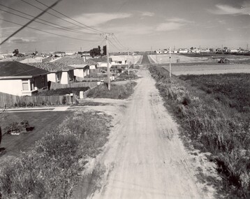
Photograph - Black and white, c. 1960
This image depicts a scene of East Bentleigh in 1960, viewed along Thomasina Street as it crosses Gladwyn Street towards East Boundary Road in the distance. The gardens and new homes are well-tended, but the street surfacing is unsealed.Developing urban area now located within the City of Glen Eira, formally City of Moorabbin. This image illustrates the mid century urban sprawl of new suburbs and the subdivision of market gardens within the municipality and the changing demographic of the district as new houses are constructed and infrastructure established. Black and white photograph of unsealed road in new development in the area of Moorabbin, new houses appear on the lefthand side with paddocks on right side of image with installation of electric poles. Sealed road in the distance. Thomasina Street, as it crosses Gladwyn Street, East Bentleigh towards East Boundary Road. Handwritten in blue ink: 60 - 373 D Handwritten in red ink: 80% Handwritten in black ink: Ch. 6bentleigh, east bentleigh, market garden, housing, suburbs, infrastructure, moorabbin -
City of Kingston
Photograph - Black and white, 27 February 1964
Cheltenham is a suburb in the City of Kingston that was originally established as a rural market gardening community. The area is bordered by Highett. The previous market gardens, farms and paddocks have gradually been sub-divided into housing and industrial estates. The Methodist Children's Home Methodist Homes for Children and St John of God Training Centre on the site of the future Southland shopping centre has not yet been demolished. The recently built Cheltenham High School is visible and the increased urbansation of the area is evident. Some farmland remains including the Le Page homestead.The developing urban area of Cheltenham within the City of Kingston. This image illustrates the mid-century urban sprawl of of Cheltenham and the subdivision of market gardens within the municipality and the changing demographic of the district as new houses are constructed and infrastructure established.Aerial photograph of the suburbs of Cheltenham and Highett within the City of Kingston. Highett Gas Works (top left); Bernard Street, Cheltenham (top right); Weatherall Road (bottom left): Elliott and Cobham Streets Cheltenham (bottom right).White handwritten: X Vic.1831 White type: MELBOURNE 1963 PROJECT RUN23 [underlined] 27-2-64 LENS 205 152-70 M/M 5.150 [arrow] White handwritten: X 166 cheltenham, highett, urbanisation -
City of Kingston
Photograph - Black and white, 20 December 1945
This photograph depicts a section of Cheltenham with a mix of housing and market gardens. The visible market gardens, farms and paddocks have gradually been sub-divided into housing, commercial and industrial estates. A large part of Cheltenham was originally established as a rural market gardening community. The railway line and station brought urban development to the area and the gradual subdivision of farmland and large land holdings for the development of housing. Aerial photograph dated 1945 of the Cheltenham area in the City of Kingston. Sydney Street (bottom left); Sinclair Street (top left); Weymar Street area off Wilson Street, Charles Street (botton right).White print VIC-170; 57197; RUN5; PROJ.No.5; MELB.METROP AREA Lens information [indecipherable] Small photograph: clockface Black ink: 57197cheltenham, market gardens, urbanisation -
 City of Kingston
Pamphlet - Black and white, Robert McCamish & John Gilpin (Vendors), For Private Sale Station Entrance Estate, Highett, 1930s
Sales plan for land in the suburb of Highett, bounded by Wickham Road, Railway Parade, Highett Road and Point Nepean Street. The developing urban area of Highett within the City of Kingston. This land sale pamphlet illustrates the subdivision of land within the municipality and the changing demographic of the district as new houses are constructed. The extension of the railway line from the city to Mordialloc opened up the land for development.Black and white pamphlet advertising for private sale the Station Entrance Estate, Highett. Incorporates a map of the estate bordered by Wickham Road, Railway Parade, Highett Road and Point Nepean Road. Handwritten in black ink on reverse: Station Entrance / Estate / Late [indecipherable]highett, land sales, estate -
 City of Kingston
Pamphlet - Colour, Stillwell and Co, The Hill Estate Highett Great Subdivisional Auction Sale, 1917
Sales plan for land in the suburb of Highett, bounded by Point Nepean Road and incorporating Sandford Street, Turner Road, Alfred Street, Peace Street and Tennyson Street. .The developing urban area of Highett within the City of Kingston. This land sale pamphlet illustrates the subdivision of land within the municipality and the changing demographic of the district as new houses are constructed.Colour pamphlet advertising subdivisional auction sale of the Hill Estate Highett. Incorporates a map of the estate bordered by Point Nepean Road and encompassing Sandford Street, Turner Road, Alfred Street, Peace Street and Tennyson St. Handwritten in grey pencil on reverse: Hill Street / Jamieson Handwritten in blue pencil on reverse: The Hill Estate Handwritten in blue pencil on subdivision map: [tick] [on majority of properties marked on map]highett, land sales, estate -
 City of Kingston
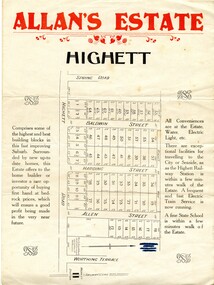
Pamphlet - Colour, Allan's Estate Highett, 1930s
Sales plan for land in the suburb of Highett, bounded by Spring Road, Highett Road and Worthing Terrace.The developing urban area of Highett within the City of Kingston. This land sale pamphlet illustrates the subdivision of land within the municipality and the changing demographic of the district as new houses are constructed.Colour pamphlet advertising Allan's Estate, Highett. Incorporates a map of the estate bordered by Spring Road, Highett Road and Worthing Terrace.Handwritten in grey pencil on reverse: Allan's Estate / Highett Crossed out in blue pencil on front: Name and address of what appears to be a solicitorhighett, land sales, estate -
 City of Kingston
Pamphlet - Colour, W. H. Wood Estate Agent, Subdivisional Land Auction Barker's Estate Cheltenham, 1919
Sales plan for land in the suburb of Cheltenham, along Barker StreetThe developing urban area of Cheltenham within the City of Kingston. This land sale pamphlet illustrates the subdivision of land within the municipality and the changing demographic of the district as new houses are constructed.Colour pamphlet advertising subdivisional land auction of Barker's estate, on Barker Street Cheltenham.Handwritten in grey pencil on the subdivision map: a series of numbers on each block possibly indicating the sale price. Handwritten in grey pencil on the subdivision map: Roy- joined to subdivision 6 Handwritten in grey pencil on the subdivision map: x on the border between subdivision 17 and 16, and again on the border between subdivision 12 and 11.cheltenham, land sales, estate -
 City of Kingston
Pamphlet - Black and white, Stott & Burke, Highland Estate Bentleigh, c.1915
Sales plan for land in the suburb of Bentleigh, along Collins and Ross Streets, bounded by Jasper Road.The developing urban area of Bentleigh within the City of Kingston. This land sale pamphlet illustrates the subdivision of land within the municipality and the changing demographic of the district as new houses are constructed.Black and white pamphlet advertising for private sale the Highland Estate, Bentleigh. Incorporates a map of the estate between Collins St and Ross St, bordered by Japser Road. Handwritten in grey pencil on map: additional subdivisions numbered 15-19 drawn along Ross St Handwritten in grey pencil on map: indecipherable annotations to subdivisions 1, 3 and 14land sales, bentleigh, estate -
 City of Kingston
Pamphlet - Colour, Ozone Hill Estate, Cheltenham, 1923
Sales plan for land in the suburb of Cheltenham, along both sides of Victori Avenue, off Weatherall Road.The developing urban area of Cheltenham within the City of Kingston. This land sale pamphlet illustrates the subdivision of land within the municipality and the changing demographic of the district as new houses are constructed.Colour pamphlet advertising for sale the Ozone Hill Estate, Cheltenham. Incorporates a map of the estate on either side of Victor Avenue, off Weatherall Road. Handwritten in blue ink on the subdivision map: 'Sold' is written on subdivisions 1-4, 8, 11, 13, 16-26, 28, 29, 33, 39-41 Handwritten in blue ink on the subdivision map: 'House being erected' is written on subdivisions 22 and 33. Handwrittten in grey pencil adjacent to subdivisions 21 and 22: Tennis / Courts / being / constructed / here Handwritten in grey pencil at bottom of page: Revised to 30/1/24 Handwritten in grey pencil on subdivision map: assumed land sale price is recorded on subdivisions 5-9, 9-10, 12, 14-15, 27, 30-32, 34-38. land sales, cheltenham, estate -
 City of Kingston
Pamphlet - Colour, H. R. Hill & Co, Walker's Estate, Cheltenham for sale by public auction, c. 1923
Sales plan for land in the suburb of Cheltenham, encompassing both sides of Walker Grove, a section of Centre Dandenong Rd and Axelton St. The developing urban area of Cheltenham within the City of Kingston. This land sale pamphlet illustrates the subdivision of land within the municipality and the changing demographic of the district as new houses are constructed.Black and white pamphlet advertising for private sale the Station Entrance Estate, Highett. Incorporates a map of the estate bordered by Wickham Road, Railway Parade, Highett Road and Point Nepean Road.Handwritten in black pen on subdivision map: 'x' written on subdivisions 2, 3, 8-11, 15-17, 19. Potentially indicating that these properties did not sell at auction. Handwritten in black pen on subdivision map: assumed sale price on subdivisions 1, 4-7, 12-14, 18, 20-31. land sales, cheltenham, estate -
 City of Kingston
Pamphlet - Colour, Stillwell and Co, Cheltenham Charman Estate Realising Auction, 1921
Sales plan for land in the suburb of Cheltenham, along Charman Road and Weatherall Street.The developing urban area of Cheltenham within the City of Kingston. This land sale pamphlet illustrates the subdivision of land within the municipality and the changing demographic of the district as new houses are constructed.Colour pamphlet advertising realising auction of the Charman Estate, Cheltenham. Incorporates a map of the estate, showing subdivisions along Charman Road and Weatherall Street.land sales, cheltenham, estate -
 City of Kingston
Pamphlet - Colour, Duffus Bros, Railway Reserve Highett, c. 1923
Sales plan for land in the suburb of Highett, titled Railway Reserve, incorporating properties along Wolseley Street, Livingston Street, Highett Road and Worthing Road. The developing urban area of Highett within the City of Kingston. This land sale pamphlet illustrates the subdivision of land within the municipality and the changing demographic of the district as new houses and shops are constructed close to infrastructure.Colour pamphlet advertising thirty eight shop and villa sites for sale at the Railway Reserve, Highett. Incorporates a map of the reserve with properties available on Wolseley Street, Livingston Street, Highett Road and Worthing Road. Handwritten in grey pencil: assumed sale price recorded on subdivisions 1-7, 10, 22, 23 and 34 Handwritten in grey pencil on subdivision 4: C. Nevill / City of Melbourne bank Handwritten in grey pencil across subdivision 7: 49' Handwritten in grey pencil across subdivision 21 and 22: 134' Handwritten in grey pencil across subdivision 25 and 26: 200' Handwritten in grey pencil across subdivision 36 and 37 and both top and bottom: 120' Hand drawn in blue pencil: outline of subdivision 4 Hand drawn in blue pencil: outline of subdivisions 7, 23, 28, 37, 38 along left hand side, subdivisions 38, 37 and 36 on Wolseley Street, subdivisions 30 and 29 along Wolseley Street, subdivisions 29 and 24 along the middle of the plan, subdivisions 24 and half of 25 along Livingston Street, half of subdivision 20 along the middle of the plan, subdivisions 21 and 22 along the Right of Way between Livingston Street and Highett Road, and along the right hand border of subdivision 7. Handwritten in ink adjacent to the subdivision plan, updside down, in the bottom right hand corner: 276 / 54 / 280 / 45 / 320 / 202 / 200 / 134 / horizontal line / 11/14 Handwritten in ink adjacent to the subdivision plan, updside down, in the bottom right hand corner: 1714)2200(15 / 1714 / horizontal line / 486land sales, highett -
 City of Kingston
Pamphlet - Colour, Roy Dunn Pty. Ltd, Central Corner Estate Moorabbin and Highett, c. 1923
Sales plan for land in the suburbs of Highett and Moorabbin, bordered by Point Nepean Road and Wickham Road East incorporating William StreetThe developing urban area of Highett and Moorabbin within the City of Kingston. This land sale pamphlet illustrates the subdivision of land within the municipality and the changing demographic of the district as new houses are constructed close to infrastructure.Colour pamphlet advertising for private sale land in the Central Corner Estate in Moorabbin and Highett. Incorporates a map of the estate bordered by Point Nepean Road and Wickham Road East, with subdivisions also available on both sides of William Street. Handwritten in blue pencil on subdivision plan: a tick is drawn on subdivisions 2-18 Handwritten in blue pencil on subdivision 6: a box with an x inside Handwritten in blue pencil on subdivisions 10 and 12: S Handwritten in black ink on front page: [indecipherable] / McKittricks Handwritten in grey pencil on rear page: McKilhick / Nepean Rd Handwritten in grey pencil on rear page upside down: 160000 / 15 8300 [crossed out] land sales, estate, highett, moorabbin -
 City of Kingston
Pamphlet - Colour, Roy Dunn Pty. Ltd, Subdivisional auction of Highett Station Estate, c.1924
Sales plan for land in the suburb of Highett, bounded by Worthing Road, and the Melbourne to Frankston Electric Railway Line, including LePage Street. The developing urban area of Highett within the City of Kingston. This land sale pamphlet illustrates the subdivision of land within the municipality and the changing demographic of the district as new houses are constructed close to infrastructure.Colour pamphlet advertising a subdivisional auction of the Highett Station Estate. Incorporates a map of the estate bordered by Worthing Road and the Melbourne to Frankston Electric Railway, and including LePage Street. Handwritten in black ink on front cover: Late LePage / Wickham Rdland sales, estate, highett -
 City of Kingston
Pamphlet - Colour, W. H. Wood Estate Agent, Realising sub-divisional auction sale Bentleigh Park Estate, Bentleigh, 1920
Sales plan for land in the suburb of Bentleigh, bounded by Centre Road, and incorporating subdivisions on either side of Elizabeth Street (Wheatley Road), Oak Street and Beech Street.The developing urban area of Bentleigh within the City of Kingston. This land sale pamphlet illustrates the subdivision of land within the municipality and the changing demographic of the district as new houses are constructed close to infrastructure.Colour pamphlet advertising a realising sub-divisional auction sale of the Bentleigh Park Estate, Bentleigh. Incorporates a map of the estate bordered by Centre Road, and including Elizabeth Street (Wheatley Road), Oak Street and Beech Street.Hand drawn in grey pencil: a small square on subdivision 33 Hand drawn in grey pencil: a small square incorporating a cross on subdivision 24 Hand written in black ink on reverse: Bentleigh Park / Estate / Ward late Andersonsland sales, estate, bentleigh -
 City of Kingston
Pamphlet - Colour, T. H. Ould Publishing Co, The Ridge Estate, Cheltenham, c. 1930
Sales plan for land in the suburb of Cheltenham, bounded by Johnston Street, Silver Street and Cavanagh Street, incorporating lots on either side of Sunray Avenue.The developing urban area of Cheltenham within the City of Kingston. This land sale pamphlet illustrates the subdivision of land within the municipality and the changing demographic of the district as new houses are constructed close to infrastructure.Colour pamphlet advertising for sale lots in The Ridge Entrance Estate, Cheltenham. Incorporates a map of the estate bordered by Johnston Street, Silver Street and Cavanagh Street, including subdivision lots on either side of Sunray Avenueland sales, estate, cheltenham