Showing 1565 items
matching development buildings
-
 Kew Historical Society Inc
Plan, Melbourne & Metropolitan Board of Works : Borough of Kew : Detail Plan No.1581, 1904
The Melbourne and Metropolitan Board of Works (MMBW) plans were produced from the 1890s to the 1950s. They were crucial to the design and development of Melbourne's sewerage and drainage system. The plans, at a scale of 40 feet to 1 inch (1:480), provide a detailed historical record of Melbourne streetscapes and environmental features. Each plan covers one or two street blocks (roughly six streets), showing details of buildings, including garden layouts and ownership boundaries, and features such as laneways, drains, bridges, parks, municipal boundaries and other prominent landmarks as they existed at the time each plan was produced. (Source: State Library of Victoria)This plan forms part of a large group of MMBW plans and maps that was donated to the Society by the Mr Poulter, City Engineer of the City of Kew in 1989. Within this collection, thirty-five hand-coloured plans, backed with linen, are of statewide significance as they include annotations that provide details of construction materials used in buildings in the first decade of the 20th century as well as additional information about land ownership and usage. The copies in the Public Record Office Victoria and the State Library of Victoria are monochrome versions which do not denote building materials so that the maps in this collection are invaluable and unique tools for researchers and heritage consultants. A number of the plans are not held in the collection of the State Library of Victoria so they have the additional attribute of rarity.Original survey plan, issued by the MMBW to a contractor with responsibility for constructing sewers in the area identified on the plan within the Borough of Kew. The plan was at some stage hand-coloured, possibly by the contractor, but more likely by officers working in the Engineering Department of the Borough and later Town, then City of Kew. The hand-coloured sections of buildings on the plan were used to denote masonry or brick constructions (pink), weatherboard constructions (yellow), and public buildings (grey). The streets and built structures in this plan were surveyed in 1903 and released to contractors in 1904. In addition to the designation of building types by colour, the plan includes detailed descriptions of land use and ownership. While many buildings remain from this period, a number of the buildings represented have been demolished including the original Kew Town Hall, and the Congregational and Roman Catholic churches in Walpole Street. While the mansion ‘Illapa’ in Princess Street is still extant – now part of ‘Rylands’ – the neighbouring mansion ‘Elsmere’ was demolished some decades ago. Rivalling Illapa and Elsmere in size were two mansions in Walpole Street, one named on the plan as ‘Gnarlbine’. Over time, Kew Junction and the south side of High Street have been reconfigured and widened, so that the commercial buildings on the corner of Princess and High Street no longer exist. A surprising feature of this part of central Kew to the northwest of Kew Junction is the amount of vacant land. In a number of cases, this land is noted by the contractor as used for vegetable gardens.melbourne and metropolitan board of works, detail plans, maps - borough of kew, mmbw 1581, cartography -
 Kew Historical Society Inc
Plan, Melbourne & Metropolitan Board of Works : Borough of Kew : Detail Plan No.1582, 1904
The Melbourne and Metropolitan Board of Works (MMBW) plans were produced from the 1890s to the 1950s. They were crucial to the design and development of Melbourne's sewerage and drainage system. The plans, at a scale of 40 feet to 1 inch (1:480), provide a detailed historical record of Melbourne streetscapes and environmental features. Each plan covers one or two street blocks (roughly six streets), showing details of buildings, including garden layouts and ownership boundaries, and features such as laneways, drains, bridges, parks, municipal boundaries and other prominent landmarks as they existed at the time each plan was produced. (Source: State Library of Victoria)This plan forms part of a large group of MMBW plans and maps that was donated to the Society by the Mr Poulter, City Engineer of the City of Kew in 1989. Within this collection, thirty-five hand-coloured plans, backed with linen, are of statewide significance as they include annotations that provide details of construction materials used in buildings in the first decade of the 20th century as well as additional information about land ownership and usage. The copies in the Public Record Office Victoria and the State Library of Victoria are monochrome versions which do not denote building materials so that the maps in this collection are invaluable and unique tools for researchers and heritage consultants. A number of the plans are not held in the collection of the State Library of Victoria so they have the additional attribute of rarity.Original survey plan, issued by the MMBW to a contractor with responsibility for constructing sewers in the area identified on the plan within the Borough of Kew. The plan was at some stage hand-coloured, possibly by the contractor, but more likely by officers working in the Engineering Department of the Borough and later Town, then City of Kew. The hand-coloured sections of buildings on the plan were used to denote masonry or brick constructions (pink), weatherboard constructions (yellow), and public buildings (grey). Public buildings, coloured grey on the Plan 1582 include the police station and post office, churches and schools. The earliest church school, Common School No.356 was located at the rear of the Congregational Church in Peel Street. It was constructed in 1859. The first buildings of Kew Primary School No.1075 on the other side of Peel Street were constructed in 1871. The school in 1903 only occupied a small fraction of its current site. In 1903, where the rear playground is now located, were two weatherboard and one brick villa. Trinity Grammar School was founded in 1902 and opened in the Parish Hall at the rear of Holy Trinity Anglican Church. It was not to move to its current site until 1906. The outline of the building housing the Kew Fire Brigade in the centre of the north side of Walton Street is shown but not named on the plan. Further down Pakington Street stood the two-storey Italianate mansion ‘Overton’. The home of Stanford Chapman, it was to be featured in the Imperial Institute series of bromide photographs of Victoria, Vol. 1: Homes and scenery. It was later to become a boarding house before it was later demolished.melbourne and metropolitan board of works, detail plans, maps - borough of kew, mmbw 1582, cartography -
 Kew Historical Society Inc
Plan, Melbourne & Metropolitan Board of Works : Borough of Kew : Detail Plan No.1585, 1904
The Melbourne and Metropolitan Board of Works (MMBW) plans were produced from the 1890s to the 1950s. They were crucial to the design and development of Melbourne's sewerage and drainage system. The plans, at a scale of 40 feet to 1 inch (1:480), provide a detailed historical record of Melbourne streetscapes and environmental features. Each plan covers one or two street blocks (roughly six streets), showing details of buildings, including garden layouts and ownership boundaries, and features such as laneways, drains, bridges, parks, municipal boundaries and other prominent landmarks as they existed at the time each plan was produced. (Source: State Library of Victoria)This plan forms part of a large group of MMBW plans and maps that was donated to the Society by the Mr Poulter, City Engineer of the City of Kew in 1989. Within this collection, thirty-five hand-coloured plans, backed with linen, are of statewide significance as they include annotations that provide details of construction materials used in buildings in the first decade of the 20th century as well as additional information about land ownership and usage. The copies in the Public Record Office Victoria and the State Library of Victoria are monochrome versions which do not denote building materials so that the maps in this collection are invaluable and unique tools for researchers and heritage consultants. A number of the plans are not held in the collection of the State Library of Victoria so they have the additional attribute of rarity.Original survey plan, issued by the MMBW to a contractor with responsibility for constructing sewers in the area identified on the plan within the Borough of Kew. The plan was at some stage hand-coloured, possibly by the contractor, but more likely by officers working in the Engineering Department of the Borough and later Town, then City of Kew. The hand-coloured sections of buildings on the plan were used to denote masonry or brick constructions (pink), weatherboard constructions (yellow), and public buildings (grey). This plan, which covers parts of High Street, Pakington Street and Derby Street is dominated by two historic Kew mansions: ‘Konetta’ and ‘Ramornie’. Ramornie was constructed in 1890 for James Maitland Campbell, three times Mayor of Kew. Sold in 1940, it became a boarding house known as ‘The Towers’. Now a private residence again, it has only one of its three balconies remaining. The location of the missing two balconies can be seen on the plan. In 1903, the grounds of Ramornie included a large tennis court fronting Pakington Street. The rear of the property is shown as extending to Cobden Street. One of Kew’s oldest hotels, the Prospect Hill Hotel on the corner of High and Cobden Street was established in 1858. The outline of the hotel shown on the plan represents the second building on the site. During the 19th century it was often used for electoral meetings. The Prospect Hill Hotel was to be redeveloped again in 1928, by the local architect Robert McIntyre. Since the 1980s, the hotel has been a live music venue, the home of the Melbourne Jazz Club, a restaurant and a liquor outlet.melbourne and metropolitan board of works, detail plans, maps - borough of kew, mmbw 1585, cartography -
 Kew Historical Society Inc
Plan, Melbourne & Metropolitan Board of Works : Borough of Kew : Detail Plan No.1588, 1904
The Melbourne and Metropolitan Board of Works (MMBW) plans were produced from the 1890s to the 1950s. They were crucial to the design and development of Melbourne's sewerage and drainage system. The plans, at a scale of 40 feet to 1 inch (1:480), provide a detailed historical record of Melbourne streetscapes and environmental features. Each plan covers one or two street blocks (roughly six streets), showing details of buildings, including garden layouts and ownership boundaries, and features such as laneways, drains, bridges, parks, municipal boundaries and other prominent landmarks as they existed at the time each plan was produced. (Source: State Library of Victoria)This plan forms part of a large group of MMBW plans and maps that was donated to the Society by the Mr Poulter, City Engineer of the City of Kew in 1989. Within this collection, thirty-five hand-coloured plans, backed with linen, are of statewide significance as they include annotations that provide details of construction materials used in buildings in the first decade of the 20th century as well as additional information about land ownership and usage. The copies in the Public Record Office Victoria and the State Library of Victoria are monochrome versions which do not denote building materials so that the maps in this collection are invaluable and unique tools for researchers and heritage consultants. A number of the plans are not held in the collection of the State Library of Victoria so they have the additional attribute of rarity.Original survey plan, issued by the MMBW to a contractor with responsibility for constructing sewers in the area identified on the plan within the Borough of Kew. The plan was at some stage hand-coloured, possibly by the contractor, but more likely by officers working in the Engineering Department of the Borough and later Town, then City of Kew. The hand-coloured sections of buildings on the plan were used to denote masonry or brick constructions (pink), weatherboard constructions (yellow), and public buildings (grey). This plan shows the original configuration of the Kew Post Office, Court House and Police Station, which had opened in 1888. This configuration was to essentially remain until the purchase of the Court House and Police Station by the City of Boroondara in 2007 and its subsequent renovation. Interestingly, the MMBW surveyors incorrectly labelled parts of the complex. In the triangle in front of the Post Office, before the erection of the Kew Cenotaph in 1925, was located a lawn and the Queen Victoria Jubilee Fountain. While many of the shops on the south side of High street had been constructed by 1903 a number of sites were still used as vegetable gardens. Further along High Street, on the corner of Charles Street, the Salvation Army Barracks can be seen on the plan. These Barracks predate the later Citadel and ‘Young People’s Hall’ that were opened in 1919. At 22 Charles Street can be seen the house of James Venn Morgan. Hailed as the ‘father of Kew’, Morgan arrived in Melbourne in 1840. He was first engaged as a bookmaker, but a fortunate venture on the goldfields enabled him to purchase land in Kew. He conducted a market garden and dairy in Kew for many years.melbourne and metropolitan board of works, detail plans, maps - borough of kew, mmbw 1588, cartography -
 Kew Historical Society Inc
Plan, Melbourne & Metropolitan Board of Works : Borough of Kew : Detail Plan No.1590, 1905
The Melbourne and Metropolitan Board of Works (MMBW) plans were produced from the 1890s to the 1950s. They were crucial to the design and development of Melbourne's sewerage and drainage system. The plans, at a scale of 40 feet to 1 inch (1:480), provide a detailed historical record of Melbourne streetscapes and environmental features. Each plan covers one or two street blocks (roughly six streets), showing details of buildings, including garden layouts and ownership boundaries, and features such as laneways, drains, bridges, parks, municipal boundaries and other prominent landmarks as they existed at the time each plan was produced. (Source: State Library of Victoria)This plan forms part of a large group of MMBW plans and maps that was donated to the Society by the Mr Poulter, City Engineer of the City of Kew in 1989. Within this collection, thirty-five hand-coloured plans, backed with linen, are of statewide significance as they include annotations that provide details of construction materials used in buildings in the first decade of the 20th century as well as additional information about land ownership and usage. The copies in the Public Record Office Victoria and the State Library of Victoria are monochrome versions which do not denote building materials so that the maps in this collection are invaluable and unique tools for researchers and heritage consultants. A number of the plans are not held in the collection of the State Library of Victoria so they have the additional attribute of rarity.Original survey plan, issued by the MMBW to a contractor with responsibility for constructing sewers in the area identified on the plan within the Borough of Kew. The plan was at some stage hand-coloured, possibly by the contractor, but more likely by officers working in the Engineering Department of the Borough and later Town, then City of Kew. The hand-coloured sections of buildings on the plan were used to denote masonry or brick constructions (pink), weatherboard constructions (yellow), and public buildings (grey). Surveyed by the Board of Works in 1903 and published in 1904, Plan No.1590 shows development north of Cotham Road. While this plan includes built structures in Mary Street, Cotham Road, High Street, Park Hill Road, Kent Street, Ridgeway Avenue, and Ermington Lane (now Ermington Place), only part of this section was notated and coloured in this contractor’s copy. Numerous houses, large and small are named on the plan: ‘Cholula’, ‘Belper’, ‘The Uplands’, ‘Spring Grove’ facing Cotham Road; ‘Marion’ facing Kent Street; and ‘Kia Ora’ facing Ridgeway Avenue.melbourne and metropolitan board of works, detail plans, mmbw 1590, survey plans - borough of kew, cartography -
 Kew Historical Society Inc
Plan, Melbourne & Metropolitan Board of Works : Borough of Kew : Detail Plan No.1591, 1905
The Melbourne and Metropolitan Board of Works (MMBW) plans were produced from the 1890s to the 1950s. They were crucial to the design and development of Melbourne's sewerage and drainage system. The plans, at a scale of 40 feet to 1 inch (1:480), provide a detailed historical record of Melbourne streetscapes and environmental features. Each plan covers one or two street blocks (roughly six streets), showing details of buildings, including garden layouts and ownership boundaries, and features such as laneways, drains, bridges, parks, municipal boundaries and other prominent landmarks as they existed at the time each plan was produced. (Source: State Library of Victoria)This plan forms part of a large group of MMBW plans and maps that was donated to the Society by the Mr Poulter, City Engineer of the City of Kew in 1989. Within this collection, thirty-five hand-coloured plans, backed with linen, are of statewide significance as they include annotations that provide details of construction materials used in buildings in the first decade of the 20th century as well as additional information about land ownership and usage. The copies in the Public Record Office Victoria and the State Library of Victoria are monochrome versions which do not denote building materials so that the maps in this collection are invaluable and unique tools for researchers and heritage consultants. A number of the plans are not held in the collection of the State Library of Victoria so they have the additional attribute of rarity.Original survey plan, issued by the MMBW to a contractor with responsibility for constructing sewers in the area identified on the plan within the Borough of Kew. The plan was at some stage hand-coloured, possibly by the contractor, but more likely by officers working in the Engineering Department of the Borough and later Town, then City of Kew. The hand-coloured sections of buildings on the plan were used to denote masonry or brick constructions (pink), weatherboard constructions (yellow), and public buildings (grey). That area of Kew bordered by Cotham Road, Park Hill Road, Ermington Lane (now Ermington Place), and Belmont Avenue contained some of the significant homes owned by Kew pioneers. Chief among these was ‘Park Hill’ on an enormous lot facing Park Hill Road. The Jubilee History of 1910 noted, six years after this plan was drawn, that: ‘Park Hill Road, forming the southern boundary of the cemetery, takes its name from Park Hill, the residence of Mr. Thomas Judd, who has resided there since December, 1852.’ Other named houses on the plan include ‘Ferndale’ facing Cotham Road; ‘Ermington’ adjacent to Judd’s Park Hill, facing Park Hill Road; and ‘Gilden’ and ‘Mont Belmont’ facing Belmont Avenue. Mont Belmont was designed by the architectural firm of Reed, Henderson and Smart for William George Lilley in 1887 and was completed in 1888. Lilley was Mayor of Kew in 1887-88, a Justice of the Peace and a member of the first Board of Guardians of Kew’s St. Hilary’s Church of England.melbourne and metropolitan board of works, detail plans, survey plans - borough of kew, mmbw 1591, cartography -
 Kew Historical Society Inc
Plan, Melbourne & Metropolitan Board of Works : Borough of Kew : Detail Plan No.1592, 1905
The Melbourne and Metropolitan Board of Works (MMBW) plans were produced from the 1890s to the 1950s. They were crucial to the design and development of Melbourne's sewerage and drainage system. The plans, at a scale of 40 feet to 1 inch (1:480), provide a detailed historical record of Melbourne streetscapes and environmental features. Each plan covers one or two street blocks (roughly six streets), showing details of buildings, including garden layouts and ownership boundaries, and features such as laneways, drains, bridges, parks, municipal boundaries and other prominent landmarks as they existed at the time each plan was produced. (Source: State Library of Victoria). This plan forms part of a large group of MMBW plans and maps that was donated to the Society by the Mr Poulter, City Engineer of the City of Kew in 1989. Within this collection, thirty-five hand-coloured plans, backed with linen, are of statewide significance as they include annotations that provide details of construction materials used in buildings in the first decade of the 20th century as well as additional information about land ownership and usage. The copies in the Public Record Office Victoria and the State Library of Victoria are monochrome versions which do not denote building materials so that the maps in this collection are invaluable and unique tools for researchers and heritage consultants. A number of the plans are not held in the collection of the State Library of Victoria so they have the additional attribute of rarity.Original survey plan, issued by the MMBW to a contractor with responsibility for constructing sewers in the area identified on the plan within the Borough of Kew. The plan was at some stage hand-coloured, possibly by the contractor, but more likely by officers working in the Engineering Department of the Borough and later Town, then City of Kew. The hand-coloured sections of buildings on the plan were used to denote masonry or brick constructions (pink), weatherboard constructions (yellow), and public buildings (grey). In MMBW Plan No.1592, the pink line indicates that area of the plan for which the contracting engineer was responsible. Included in the Plan are a number of primarily brick villas in a section of Belmont Avenue off Cotham Road. The house ‘Uvadale’ north of Belmont Avenue, and facing Cotham Road is also included in the contract. Excluded from the contract but shown on the Plan are ‘Glendonald’, ‘Mont Belmont’ and ‘Gilden’.melbourne and metropolitan board of works, detail plans, survey plans - borough of kew, mmbw 1592, cartography -
 Kew Historical Society Inc
Plan, Melbourne & Metropolitan Board of Works / Borough of Kew, Detail Plan No.1593, 1905
The Melbourne and Metropolitan Board of Works (MMBW) plans were produced from the 1890s to the 1950s. They were crucial to the design and development of Melbourne's sewerage and drainage system. The plans, at a scale of 40 feet to 1 inch (1:480), provide a detailed historical record of Melbourne streetscapes and environmental features. Each plan covers one or two street blocks (roughly six streets), showing details of buildings, including garden layouts and ownership boundaries, and features such as laneways, drains, bridges, parks, municipal boundaries and other prominent landmarks as they existed at the time each plan was produced. (Source: State Library of Victoria)This plan forms part of a large group of MMBW plans and maps that was donated to the Society by the Mr Poulter, City Engineer of the City of Kew in 1989. Within this collection, thirty-five hand-coloured plans, backed with linen, are of statewide significance as they include annotations that provide details of construction materials used in buildings in the first decade of the 20th century as well as additional information about land ownership and usage. The copies in the Public Record Office Victoria and the State Library of Victoria are monochrome versions which do not denote building materials so that the maps in this collection are invaluable and unique tools for researchers and heritage consultants. A number of the plans are not held in the collection of the State Library of Victoria so they have the additional attribute of rarity.Original survey plan, issued by the MMBW to a contractor with responsibility for constructing sewers in the area identified on the plan within the Borough of Kew. The plan was at some stage hand-coloured, possibly by the contractor, but more likely by officers working in the Engineering Department of the Borough and later Town, then City of Kew. The hand-coloured sections of buildings on the plan were used to denote masonry or brick constructions (pink), weatherboard constructions (yellow), and public buildings (grey). The laborious task of hand-tinting these Board of Works plans was not without hazards as is evidenced by Plan No. 1593. On the Plan, the original colourist spilt black and green ink, partially obscuring some parts. The most obvious casualty is ‘Clifton’ located on the corner of Cotham Road and Park Street [now Adeney Avenue]. Included in this Plan, and outlined in pink is that part of the section that the contracting engineer was tasked with completing. This included sewering on both sides of this part of Cotham Road, but excluded properties such as ‘Glendonald’ and ‘Monnington’. This area was to undergo a series of subdivisions including the ‘Clifton Estate’, which created housing lots on Adeney Avenue and Florence Avenue in 1916. The most notable occupant of Clifton was William Adeney [died 1893], a pioneer of Camperdown, after which Park Street was later renamed.melbourne and metropolitan board of works, detail plans, survey plans - borough of kew, mmbw 1593, cartography -
 Kew Historical Society Inc
Plan, Melbourne & Metropolitan Board of Works : Contour Plan of Melbourne & Suburbs : Melbourne Sewage, 1894
The Melbourne and Metropolitan Board of Works (MMBW) plans were produced from the 1890s to the 1950s. They were crucial to the design and development of Melbourne's sewerage and drainage system. This plan forms part of a large group of MMBW plans and maps that was donated to the Society by the Mr Poulter, City Engineer of the City of Kew in 1989. Within this collection, thirty-five hand-coloured plans, backed with linen, are of statewide significance as they include annotations that provide details of construction materials used in buildings in the first decade of the 20th century as well as additional information about land ownership and usage. The copies in the Public Record Office Victoria and the State Library of Victoria are monochrome versions which do not denote building materials so that the maps in this collection are invaluable and unique tools for researchers and heritage consultants. A number of the plans are not held in the collection of the State Library of Victoria so they have the additional attribute of rarity.Digital copy of an original MMBW plan. This contour plan shows the area identified by the MMBW for purposes of drainage and sewerage in 1894. The suburbs represented extend from Williamstown in the west to Bulleen in the east, and from Preston in the north, south to Sandringham. Suburbs are outlined in coloured ink. Red lines indicate main and branch sewers in existence at the beginning of 1894 in central and inner Melbourne. These extended as far as Williamstown and Brighton, but not yet as far as Kew, where sewering did not commence until 1901. Contour lines show the topography, which was important for indicating the fall of the land for the laying of sewers and drainage channels. Kew appears to be fairly undeveloped at this date except for railway lines and stations (the Kew and Outer Circle lines), main roads, the Kew Lunatic Asylum Reserve and Studley Park. However, the contour plan does not accurately represent the density of settlement, nor the large number of houses, which were being built in Kew and other suburbs from the 1850s to the land boom of the late 1880’s and early 1890’s. This plan is part of a large and historically significant group of MMBW plans and maps that was donated to the Society by the Mr Poulter, City Engineer of the City of Kew in 1989.mmbw contour plan of melbourne and suburbs, melbourne and metropolitan board of works, melbourne sewage, cartography -
 Kew Historical Society Inc
Plan - Subdivision Plan, J R Mathers & McMillan, Myrtle Hill Estate, East Kew, circa 1949, c.1949
The Kew Historical Society's map collection includes a substantial number of real estate subdivision plans, mainly of Kew but also of surrounding suburbs in Melbourne. Most of the subdivision plans date from the 1920s and 1930s when the districts old homes and local farmland were being split up to accommodate residential growth in the postwar period. These early plans were assembled by a local firm, Jas R Mather & McMillan, which had an office in Cotham Road. Many of the plans, and sometimes photos, were annotated by the agents.Subdivision plans are historically important documents used as evidence for the growth of suburbs in Australia. They frequently provide information about when the land was sold as well as evidence relating to surveyors and real estate and financial agents. The numerous subdivision plans in the Kew Historical Society's collection represent working documents, ranging from the initial sketches made in planning a subdivision to printed plans on which auctioneers or agents listed the prices for which individual lots were sold. In a number of cases, the reverse of a subdivision plan in the collection includes a photograph of a house that was also for sale by the agent. These photographs provide significant heritage information relating house design and decoration, fencing and household gardens.The photograph may also be aesthetically significant depending on the importance of the photographic atelier.Myrtle Hill, at 14 Vista Avenue, Kew, is of local historical and architectural significance as a good example of a large and imposing single-storey Italianate house of the early 1870s surviving in Kew. Originally sited on a large allotment overlooking Normanby Road, the setting of the house has been dramatically altered through extensive subdivision and development. The subdivision plan of the ‘Myrtle Hill Estate’ indicates that in one such subdivision, 11 allotments were created fronting Bowyer Avenue, Myrtle Avenue, and Normanby Road. The outline and building profile of Myrtle Hill is shown on the west side of Bowyer Avenue.The full (typed) title of this subdivision plan is :"Plan of SUBDIVISION of part of CROWN PORTION 83. / at KEW / PARISH OF BOROONDARA. / COUNTY OF BOURKE". / "MYRTLE HILL ESTATE / EAST KEW" In addition to the Title and subtitle, the plan also lists the advantages of the subdivision. -
 Kew Historical Society Inc
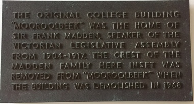
Plaque - Commemorative Plaque, Institute of Early Childhood Development, 'Mooroolbeek', Madden Grove, Kew, c.1968
The Free Kindergarten Union of Victoria commenced teacher training in 1909. A two year course was run in cooperation with the Education Department in 1910-14, but from 1917 the Union trained its students independently. In 1922 the Kindergarten Training College was established in Mooroolbeek, Kew. In 1965, the institution, as the Melbourne Kindergarten Teachers' College, became an entity separate from the Union, and in 1973 joined the State College of Victoria as the Institute of Early Childhood Development. It subsequently amalgamated with the University of Melbourne to become the Department of Early Childhood Studies and moved from Madden Grove, Kew, to 234 Queensberry St, Carlton, early in July 1997.Commemorative plaque indicating the location of a former Kew mansionBronze plaque commemorating the location of Mooroolbeek, one of the great mansions of Kew, demolished in 1968 by the Kindergarten Training College"The original college building "Mooroolbeek" was the home of Sir Frank Madden Speaker of the Victorian Legislative Assembly from 1904-1917. The crest of the Madden family here inset was removed from "Mooroolbeek" when the building was demolished in 1968."institute of early childhood development - kew (vic), mooroolbeek - madden grove - kew (vic), sir frank madden -
 Kew Historical Society Inc
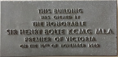
Plaque - Commemorative Plaque, Institute of Early Childhood Development, This building was opened by the Honorable Sir Henry Bolte KCMG MLA, Premier of Victoria, on the 10th December 1969, 1969
... Childhood Development This building was opened by the Honorable Sir ...The Free Kindergarten Union of Victoria commenced teacher training in 1909. A two year course was run in cooperation with the Education Department in 1910-14, but from 1917 the Union trained its students independently. In 1922 the Kindergarten Training College was established in Mooroolbeek, Kew. In 1965, the institution, as the Melbourne Kindergarten Teachers' College, became an entity separate from the Union, and in 1973 joined the State College of Victoria as the Institute of Early Childhood Development. It subsequently amalgamated with the University of Melbourne to become the Department of Early Childhood Studies and moved from Madden Grove, Kew, to 234 Queensberry St, Carlton, early in July 1997.Metal alloy plaque commemorating the opening of a building by the Premier of Victoria, Sir Henry Bolte, on 10th December 1969This building was opened by the Honorable Sir Henry Bolte KCMG MLA, Premier of Victoria, on the 10th December 1969sir henry bolte, commemorative plaques - kew (vic), institute of early childhood development -
 Kew Historical Society Inc
Archive (Sub-series) - Subject File, Development (Kew), 1958
Various partiesReference, Research, InformationSecondary Values (KHS Imposed Order)Subject file consisting largely of newspaper clippings/articles relating to houses in Kew. The earliest original newspaper article dates from 1923 and relates to housing shortages. The file contains some interesting Council records and correspondence relating to community action in response to development. These include the proposed lease of the Ground Floor of the Kew Civic Buildings as a postal delivery centre (1992), the development of flats in Studley Ward (1977), a proposed motel in Studley Park Road (1983)kew post office, heritage, planning and developmentkew post office, heritage, planning and development -
Kew Historical Society Inc
Archive (Sub-series) - Subject File, FERGUSON, Cr Hugh George, 1959
Various partiesReference, Research, InformationSecondary Values (KHS Imposed Order)Hugh George Ferguson was born in June 1900 in Williamstown. He married in 1940 and subsequently joined the Australian Imperial Forces. After the war he worked as a Billeting Affairs Organiser for the Dutch Government, resettling migrants in Australia. He also worked in advertising as an account manager, and was campaign director for Arthur Rylah is Victorian politics. After the Second World War, he organised the first major trade fairs at the Royal Exhibition Buildings including a World Trade Fair. He built a home in Brougham Street and represented North Ward on Kew Council from 1952 to 1968. He was elected Mayor for the 1959-60 term. He died in 1975, aged 75, and is buried in Boroondara Cemetery. The file on Cr. Ferguson includes newspaper articles relating to development in Kew, the new Kew Town Hall, and Cr. Ferguson’s retirement. Primary sources in the file include an original invitation to the 1959 Mayoral Dinner and the guest list, Cr Ferguson’s Registration card as a Justice of the Peace (1972), and electoral material for North Ward (1955, 1968)kew (vic) - history, kew (vic) - politics, cr. h g ferguson, hugh fergusonkew (vic) - history, kew (vic) - politics, cr. h g ferguson, hugh ferguson -
 Kew Historical Society Inc
Photograph - Photographs, Former Baptist Church, Woodlands Avenue, Kew East, 2018, 2018
The former Baptist Church, at 8-12 Woodlands Avenue, Kew East, was nominated by the Society for protection as part of the Kew East Heritage Gap Study. W D Vaughan in his 'Kew's Civic History' (1960 writes that: "With the development of East Kew, local Baptists considered the establishment of a church was necessary. A block of land was purchased in Woodlands Avenue and the foundation stone of a new church was laid on August 8, 1931. A fine Sunday school has since been erected, and special emphasis has been given to providing activities for the young people of the church"Three colour photographs of the former Baptist Church in Woodlands Avenue, Kew East. The photographs are of the front and side of the clinker brick building. One of the photographs shows the foundation stone, laid by AH Lewis Esq, 8 August 1931.churches - kew (vic), baptist church - woodlands avenue - kew (vic) -
 Kew Historical Society Inc
Plan - Subdivision Plan, Kew Golf Links Estate, 1936, 1936
... designated for industrial development and the building of a new Kodak ...The Kew Golf Links Estate was a major subdivision in North Kew. It derived its title due to the land being previously occupied by the Kew Golf Club, which transferred its course to a number of locations before occupying its current site. The Plan advertises 180 choice home sites. The street names are somewhat different today as those on the map are named after the proposed Kodak Factory to be built on the site. The subdivision of the Kew Golf Links Estate was a major subdivision of farmland in Kew. The site was at one stage designated for industrial development and the building of a new Kodak factory. The decision by Council to oppose the redevelopment makes the beginning of the period when all industrial development was banned in Kew.Monochrome printed, folded subdivision plan for the Kew Golf Links Estate, to be auctioned on 7 November 1936. Streets named include: Carnegie Avenue, Willsmere Road, Kilby Boulevarde, Kodak Avenue, Coleman Avenue, Beresford Avenue, McConchie Avenue, Cole Avenue, White Avenue, Baker Avenue, Spruzen Avenue, Tanner Avenue, Ratten Avenue, Mathers Avenue, Railway Avenue, Sutherland Avenue, and Belford Road. The position of the Yarra River and a large Drainage Reserve are marked on the plan. Lots for sale are numbered. Existing buildings are designated with a square.subdivision plans - kew (vic), kodak factory - kew (vic) -
 Kew Historical Society Inc
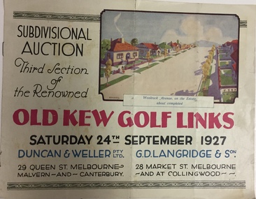
Booklet, Duncan & Weller Pty Ltd, Old Kew Golf Links Estate, 1927, 1927
... for industrial development and the building of a new Kodak factory ...The booklet advertises the third sale within the Old Golf Links Estate which was a major subdivision of farmland in North Kew in the 1920sThe subdivision of the Kew Golf Links Estate was a major subdivision of farmland in Kew. The site was at one stage designated for industrial development and the building of a new Kodak factory. The decision by Council to oppose the redevelopment makes the beginning of the period when all industrial development was banned in Kew.6 page illustrated brochure advertising the third section of a major subdivision in Kew in 1927 including 75 charming home allotments and 7 valuable building sites. The brochure includes the subdivision plan. The front cover includes a colour illustration of the almost completed houses in Woolcock Avenue. Streets named include: Kilby Road, Kodak Avenue, Baker Avenue, Mathers Avenue, Coleman Avenue, White Avenue and Belford Road. Lots for sale are numbered. Existing buildings are designated with a square.subdivisions - kew (vic), kew golf links estate -
Kew Historical Society Inc
Journal, Kewriosity : March 1991
Kew Festival 10th March to 24th March - Kew is for living / artwork Heike Effler / p1. Dates for March [1991] / p2. Easter hours [Council Offices] / 2. 10th April [Rates and dog registrations due] / p2. Voters' Roll / p2. [Kew] Community House events / p2. Commentary / Cr Daryl Oldaker p3. Council's casino letter [Willsmere] / p3. Later to the editor [Casino] / E Stanley Meyer p3. Information: your view [Council survey] / p2. Cotham Road rebuilt [reconstruction] / p4. Anybody home? [1991 Census] / p4. Valley views protected [development along the Yarra River] / p4. Reaching the tram [upgrades] / p5. Traffic management update [Area 4, Area 5, Area 6, Area 7, Area 10] / p5. 7,000 more Kewites [projected population growth] / p5. New school buildings [Ruyton Girls' School; Methodist Ladies' College; Trinity Grammar; Xavier College; Genazzano College; Carey Grammar School; Preshil] / p5. High St [Pedestrian] Crossing / p5. St George's amalgamated [with Victoria Parade Geriatric Centre, Henry Pride Unit, Hawthorn Day Hospital] / p6. Youth co-ordination [Youth Workers' Forum] / p6. Bowling vacancies [East Kew Bowling Club] / p6. Driver wanted [for Henry Pride Geriatric Centre] / p6. On World's rooftop [Trinity Grammar students and teachers in Nepal] / p6. Trinity Day / p6. Clergy move / p6. Bus volunteers [needed for Kew Community Bus] / p6. Festival artist [Heike Effler] / p7. Citizens honoured [Australia Day honours] / p7. Medallion award [Royal Guide Dogs Association] / p7. Will bunny arrive? [Three and Fours Kindergarten] / p8. Fun with your children [Highbury Grove Playgroup] / p8. 2nd birthday celebrations [Kew Recreation Centre] / p8. Free electrolysis / p8. Empress of Britain [1938 voyage] / p8. Japanese woodblocks [exhibition at East West Art] / p8. Join the cast [Viola Musical Comedy Society]Kewriosity was a local newsletter combining Kew Council and community news. It was published between November 1983 and June 1994, replacing an earlier Kewriosity [broad] Sheet (1979-84). In producing Kewriosity, Council aimed to provide a range of interesting and informative articles covering its deliberations and decision making, together with items of general interest and importance to the Kew community and information not generally available through daily media outlets.non-fictionKew Festival 10th March to 24th March - Kew is for living / artwork Heike Effler / p1. Dates for March [1991] / p2. Easter hours [Council Offices] / 2. 10th April [Rates and dog registrations due] / p2. Voters' Roll / p2. [Kew] Community House events / p2. Commentary / Cr Daryl Oldaker p3. Council's casino letter [Willsmere] / p3. Later to the editor [Casino] / E Stanley Meyer p3. Information: your view [Council survey] / p2. Cotham Road rebuilt [reconstruction] / p4. Anybody home? [1991 Census] / p4. Valley views protected [development along the Yarra River] / p4. Reaching the tram [upgrades] / p5. Traffic management update [Area 4, Area 5, Area 6, Area 7, Area 10] / p5. 7,000 more Kewites [projected population growth] / p5. New school buildings [Ruyton Girls' School; Methodist Ladies' College; Trinity Grammar; Xavier College; Genazzano College; Carey Grammar School; Preshil] / p5. High St [Pedestrian] Crossing / p5. St George's amalgamated [with Victoria Parade Geriatric Centre, Henry Pride Unit, Hawthorn Day Hospital] / p6. Youth co-ordination [Youth Workers' Forum] / p6. Bowling vacancies [East Kew Bowling Club] / p6. Driver wanted [for Henry Pride Geriatric Centre] / p6. On World's rooftop [Trinity Grammar students and teachers in Nepal] / p6. Trinity Day / p6. Clergy move / p6. Bus volunteers [needed for Kew Community Bus] / p6. Festival artist [Heike Effler] / p7. Citizens honoured [Australia Day honours] / p7. Medallion award [Royal Guide Dogs Association] / p7. Will bunny arrive? [Three and Fours Kindergarten] / p8. Fun with your children [Highbury Grove Playgroup] / p8. 2nd birthday celebrations [Kew Recreation Centre] / p8. Free electrolysis / p8. Empress of Britain [1938 voyage] / p8. Japanese woodblocks [exhibition at East West Art] / p8. Join the cast [Viola Musical Comedy Society]publications -- city of kew (vic.), kewriosity, council newsletters, community newsletters -
Kew Historical Society Inc
Document, Kew Historical Society Collection : Preservation Needs Assessment, 2021
Following a Significance Assessment, in 2020, Kew Historical Society received a Community Heritage Grant from the National Library of Australia for a Preservation Needs Assessment, prepared by Grimwade Conservation Services (GCS). The purpose of the assessment was to consider the physical condition of the collection, the suitability of the current housing and storage facilities and to make recommendations for the development of a conservation program.Illustrated 87-page Final Report by Vanessa Kowalski (Grimwade Conservation Services), including - Executive Summary / p5. Key recommendations / p7. Policies and Procedures / p9. Collection / p11. Building (Repository Structure) / p25. Environment / p33. Storage / p41. Display/Exhibitions / p54. Housekeeping / p58. Visitor Impact / p51. Disaster Preparedness / p63. Training Needs/Skills Assessment / p65. Action Plan / p67. Authorship / p71. References / p73. Appendices / p75. non-fictionFollowing a Significance Assessment, in 2020, Kew Historical Society received a Community Heritage Grant from the National Library of Australia for a Preservation Needs Assessment, prepared by Grimwade Conservation Services (GCS). The purpose of the assessment was to consider the physical condition of the collection, the suitability of the current housing and storage facilities and to make recommendations for the development of a conservation program.preservation needs assessments, kew historical society -- collections, kew historical society - conservation, community heritage grants -
Kew Historical Society Inc
Journal, The Kewriosity Sheet Vol.1 No.3 : August 1979
What's doing in Kew for August / p1. We want your news! / p1. Kew Municipal Library: Where children are VIP / p1. 25 years of service: Kew Lions Anniversary / p1. Miss Shepheard retires [Stawell Street Kindergarten] / p1. Studley Park Progress Association / p1. Entertainers needed [Kew Entertainment Workshop] / p1. Rotaract ski weekend / p1. Kew Historical Society: Memorials in Kew / p2. Children's Week 1979 / p2. Limerick of the month / p2. Theatre in Education [Kew High School] / p2. Nursing Mothers Association / p2. Mid-week tennis / p2. [Kew] Swimming Club / p2. Help where it's needed [Sacred Heart Kew Caring Group] / p2. Kew City Bowmen / p2. Holiday help [Meals on Wheels] / p2. Child Development Seminar / p2. Council News: For your safety [Roundabouts; If you're un-building [demolitions]; Traffic School; School Holidays] / p2. Citizens' Advice Bureau / p2.The Kewriosity Sheet (1979-83) was first published in the City of Kew (Victoria) in June 1979 as a two-sided 'community newssheet'. It aimed to: 'share news about Kew happenings and Kew people, and to exchange ideas about living in Kew'. Later issues gradually evolved into a 4-page, quarto sized publication. The Kewriosity Sheet was superseded by the Kew Council publication 'Kewriosity' (1983-1994).non-fictionWhat's doing in Kew for August / p1. We want your news! / p1. Kew Municipal Library: Where children are VIP / p1. 25 years of service: Kew Lions Anniversary / p1. Miss Shepheard retires [Stawell Street Kindergarten] / p1. Studley Park Progress Association / p1. Entertainers needed [Kew Entertainment Workshop] / p1. Rotaract ski weekend / p1. Kew Historical Society: Memorials in Kew / p2. Children's Week 1979 / p2. Limerick of the month / p2. Theatre in Education [Kew High School] / p2. Nursing Mothers Association / p2. Mid-week tennis / p2. [Kew] Swimming Club / p2. Help where it's needed [Sacred Heart Kew Caring Group] / p2. Kew City Bowmen / p2. Holiday help [Meals on Wheels] / p2. Child Development Seminar / p2. Council News: For your safety [Roundabouts; If you're un-building [demolitions]; Traffic School; School Holidays] / p2. Citizens' Advice Bureau / p2. community publications --- kew (vic.), the kewriosity sheet, newsletters - kew (vic.) -
Kew Historical Society Inc
Journal, The Kewriosity Sheet Vol.2 No.6 : November 1980
Kew Voluntary Helpers Building Project Opportunity Shop [Kew Elderly Citizens; Hamer Court] / p1. Kew Philharmonic Society / p2. Kew City Bowmen / p2. Kew Women's Amateur Athletic Club / p2. What's doing in Kew for November / p2. Art, Craft & Home Produce Market [Kew High School] / p3. Fete [St Paul's Church] / p3. 100 years of bowling [Kew Bowling Club] / p3. A famous farm in Kew [William Wade; Belford Farm] / Elizabeth Mackie p3. Scrabble [Kew Scrabble Club] / p3. Primary School Fete [Kew Primary School] / p4. Invitation to an exhibition / p4. Council News [Report on the Development of Hay's Paddock by Landscape Architectural Consultants - Gerner, Sanderson, Faggetter Cheesman; Kew Traffic School] / p4.The Kewriosity Sheet (1979-83) was first published in the City of Kew (Victoria) in June 1979 as a two-sided 'community newssheet'. It aimed to: 'share news about Kew happenings and Kew people, and to exchange ideas about living in Kew'. Later issues gradually evolved into a 4-page, quarto sized publication. The Kewriosity Sheet was superseded by the Kew Council publication 'Kewriosity' (1983-1994).non-fictionKew Voluntary Helpers Building Project Opportunity Shop [Kew Elderly Citizens; Hamer Court] / p1. Kew Philharmonic Society / p2. Kew City Bowmen / p2. Kew Women's Amateur Athletic Club / p2. What's doing in Kew for November / p2. Art, Craft & Home Produce Market [Kew High School] / p3. Fete [St Paul's Church] / p3. 100 years of bowling [Kew Bowling Club] / p3. A famous farm in Kew [William Wade; Belford Farm] / Elizabeth Mackie p3. Scrabble [Kew Scrabble Club] / p3. Primary School Fete [Kew Primary School] / p4. Invitation to an exhibition / p4. Council News [Report on the Development of Hay's Paddock by Landscape Architectural Consultants - Gerner, Sanderson, Faggetter Cheesman; Kew Traffic School] / p4. community publications --- kew (vic.), the kewriosity sheet, newsletters - kew (vic.) -
 Kew Historical Society Inc
Photograph - Flood at Fairfield Park, 1934
Flooding of the Yarra Valley, including that section of the Yarra bordering Kew and Kew East in the north and west of the municipality, was a regular occurrence. Extreme flood events of the Yarra River are recorded to have occurred in 1891, 1901, 1916, 1923 and 1934. The Municipality of Kew's response to these floods was to enact planning decisions restricting residential development in flood prone areas following the floods of 1916, 1921 and 1934. While floods continued after the development of the Upper Yarra Reservoir (construction 1948-57), the regularity and extent of these inundations diminished.Black and white print positive. Yarra River at Fairfield in 1934. Major flood resulting in submerged buildings in middle ground and onlookers on far bankReverse: "Flood of Yarra at Fairfield Park 1934"fairfield park, yarra valley, river yarra, floods -- 1934 -
 Kew Historical Society Inc
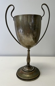
Award - Kew Bowling Club : Skippers Average Trophy, 1931-40
The Kew Bowling Club was formed in 1880 while the privately owned Auburn Heights Recreation Club was opened in 1904. By 1998, the two Clubs decided to amalgamate at the Auburn Heights site in Barkers Road, forming the Kew Heights Sports Club. The combined club was itself taken over by the Melbourne Cricket Club in 2012 becoming MCC Kew Sports Club. In 2017 MCC Kew closed and its landholding was subsequently sold to Carey Baptist Grammar School. The combined collections of the four sporting clubs making up the collection number hundreds of items that are historically and socially significant to the development of Kew. They are also significant to the sporting history of the greater Melbourne area and to the sports of lawn bowls and tennis in Australia in the 19th and 20th centuries. The collections illuminate two of the Victorian Historic Themes - 'Building community life' through forming community organisations and 'Shaping cultural and creative life' by participating in sport and recreation'.Kew Bowling Club : Skippers Average Trophy presented by S. R. PritchardKew Bowling Club presented by S. R. Pritchard / Skippers Average won by: 1931–2 G.H. Cole; 1932–3 W. Stronach; 1933–4 D.S.M. Norris; 1934–5 F.H. Rigg; 1935–6 A.E.H. Phillipps; 1936–7 P. Vance; 1937–8 D.B. Ross; 1938–9 C.G. Wood; 1939–40 W.H. Tregear; 1940–1 H. Coleman.kew bowling club, bowling clubs -- melbourne (vic.), sports awards, trophies -
![Victorian era cottage, Derby Street [Kew]](/media/collectors/550653872162f11fb04854aa/items/658f5772101c4283c6ae47ff/item-media/658f57e4101c4283c6ae493a/item-fit-380x285.jpg) Kew Historical Society Inc
Kew Historical Society IncPhotograph - Victorian era cottage, Derby Street [Kew], c. 1965
The current site of the Kew Recreation Centre in High Street Kew previously housed the Kew Depot on the corner of Disraeli Street. In nearby Derby Street, a number of original Victorian era buildings were gradually replaced due to development of the Baths precinct and commercial development.This work forms part of the collection assembled by the historian Dorothy Rogers (1905-1973), donated to the Kew Historical Society by her son in 2015. The manuscripts, photographs, maps, and documents were sourced by her from both family and local collections or produced as references for her print publications. Many were directly used by Rogers in writing ‘Lovely Old Homes of Kew’ (1961) and 'A History of Kew' (1973), or the numerous articles on local history that she produced for suburban newspapers. Most of the photographs in the collection include detailed annotations in her hand. The Rogers Collection provides a comprehensive insight into the working habits of a historian from the 1960s to the 1970s. Small single fronted cottage in Derby Street, Kew. The weatherboard cottage has a block fronted facade, and a Victorian verandah with cast iron lace.Annotation verso: "House in Derby St., next to Kew Baths (Demolished?)"dorothy rogers, derby street (kew), victorian houses -- kew (vic.) -
![Victorian era cottage, Derby Street [Kew]](/media/collectors/550653872162f11fb04854aa/items/658f7ef19239cf6fd436d1fd/item-media/658f7f019239cf6fd436d25f/item-fit-380x285.jpg) Kew Historical Society Inc
Kew Historical Society IncPhotograph - Victorian era cottage, Derby Street [Kew], c. 1965
The current site of the Kew Recreation Centre in High Street Kew previously housed the Kew Depot on the corner of Disraeli Street. In nearby Derby Street, a number of original Victorian era buildings were gradually replaced due to development of the Baths precinct and commercial development.This work forms part of the collection assembled by the historian Dorothy Rogers (1905-1973), donated to the Kew Historical Society by her son in 2015. The manuscripts, photographs, maps, and documents were sourced by her from both family and local collections or produced as references for her print publications. Many were directly used by Rogers in writing ‘Lovely Old Homes of Kew’ (1961) and 'A History of Kew' (1973), or the numerous articles on local history that she produced for suburban newspapers. Most of the photographs in the collection include detailed annotations in her hand. The Rogers Collection provides a comprehensive insight into the working habits of a historian from the 1960s to the 1970s. Small single fronted cottage in Derby Street, Kew. The weatherboard cottage has a block fronted facade, and a Victorian verandah with cast iron lace.dorothy rogers, derby street (kew), victorian houses -- kew (vic.) -
 Kew Historical Society Inc
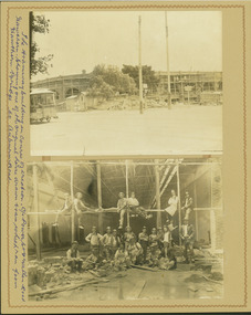
Photograph - Hawthorn Tram Depot during construction, 1915
One of a series of photographs, taken by Edgar James Dower in the second decade of the twentieth century. Born and raised in Olinda, his family later moved to Surrey Hills. He worked as an adult as a clerk in the city office of the Metropolitan Gas Company, and in his role as a 'collector', he was able to photograph scenes including the construction of tramlines and associated buildings in Kew, Hawthorn, Camberwell and Surrey Hills. Later he established a real estate agency with his brother - the E.J. Dower Real Estate Agency, Dandenong Office.The image is an historically significant record of the development of transport infrastructure which was used to connect Victorians in the first two decades of the twentieth century. This development resulted from increases in population and the consequent extension of Melbourne's suburbs. The photographs, both individually and collectively, richly detail the labour of workers and the tools and machinery used to create and extend Melbourne's tram network in the years preceding and during World War 1.Two faded original horizontal photographs, mounted on vertical card showing external and internal features of the Hawthorn Tram Depot during its construction phase. The top photo shows a panoramic view of the exterior while the second photo shows workers posed within the building.Recto: "The tramways building in course of creation. C/r of Power St & Wallen Road, Hawthorn. Showing one of the original horse drawn trams which ran from Hawthorn Bridge to Auburn Road".. theme --- travelling by tram, theme -- connecting victorians by transport and communications, tramways -- hawthorn -
 Kew Historical Society Inc
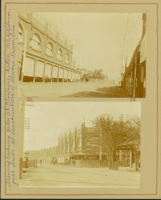
Photograph - Railway level crossing in Glenferrie Road, Glenferrie, E.J. Dower, 1912
Contextual or historic information One of a series of photographs, taken by Edgar James Dower in the second decade of the twentieth century. Born and raised in Olinda, his family later moved to Surrey Hills. He worked as an adult as a clerk in the city office of the Metropolitan Gas Company, and in his role as a 'collector', he was able to photograph scenes including the construction of tramlines and associated buildings in Kew, Hawthorn, Camberwell and Surrey Hills. Later he established a real estate agency with his brother - the E.J. Dower Real Estate Agency, Dandenong Office.The image is an historically significant record of the development of transport infrastructure which was used to connect Victorians in the first two decades of the twentieth century. This development resulted from increases in population and the consequent extension of Melbourne's suburbs. The photographs, both individually and collectively, richly detail the labour of workers and the tools and machinery used to create and extend Melbourne's tram network in the years preceding and during World War 1.Two faded original horizontal photographs, mounted on vertical card showing the original railway level crossing in Glenferrie Road, Hawthorn, before a railway overpass was constructed and the laying of the electric tramline. The two photos depict northern and southern views of the crossing. Dimensions: Photo 1 106 x 157 mm Photo 2 107 x 147 mm Mount 249 x 197 mmAnnotated recto: "Showing tramway gates at Glenferrie, taken 1912 by E.J. Dower, just prior to construction of electric tramline." Verso: "1912"theme --- travelling by tram, theme -- connecting victorians by transport and communications, trams -- boroondara (vic.), tramways -- hawthorn, trains -- hawthorn (vic.), glenferrie station -
![Electric tramway construction in Riversdale Road [Surrey Hills]](/media/collectors/550653872162f11fb04854aa/items/661deb37344c8682d4fa54e0/item-media/661dec13344c8682d4fa98bd/item-fit-380x285.jpg) Kew Historical Society Inc
Kew Historical Society IncPhotograph - Electric tramway construction in Riversdale Road [Surrey Hills], E.J. Dower, 1916
Contextual or historic information One of a series of photographs, taken by Edgar James Dower in the second decade of the twentieth century. Born and raised in Olinda, his family later moved to Surrey Hills. He worked as an adult as a clerk in the city office of the Metropolitan Gas Company, and in his role as a 'collector', he was able to photograph scenes including the construction of tramlines and associated buildings in Kew, Hawthorn, Camberwell and Surrey Hills. Later he established a real estate agency with his brother - the E.J. Dower Real Estate Agency, Dandenong Office.The image is an historically significant record of the development of transport infrastructure which was used to connect Victorians in the first two decades of the twentieth century. This development resulted from increases in population and the consequent extension of Melbourne's suburbs. The photographs, both individually and collectively, richly detail the labour of workers and the tools and machinery used to create and extend Melbourne's tram network in the years preceding and during World War 1.Digital copy of an original mounted photograph of construction of the electric tramline in Riversdale Road, Surrey Hills.Annotated verso: "Showing the commencement of preparing for electric trams in Riversdale Road / Taken from the corner of Union Road, note Essex road on right with picket fencing"theme --- travelling by tram, theme -- connecting victorians by transport and communications, trams -- boroondara (vic.), tramlines -- surrey hills -
 Kew Historical Society Inc
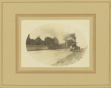
Photograph - Removal of the horse tram line in Riversdale Road, Hawthorn, E.J. Dower, c.1916
One of a series of photographs, taken by Edgar James Dower in the second decade of the twentieth century. Born and raised in Olinda, his family later moved to Surrey Hills. He worked as an adult as a clerk in the city office of the Metropolitan Gas Company, and in his role as a 'collector', he was able to photograph scenes including the construction of tramlines and associated buildings in Kew, Hawthorn, Camberwell and Surrey Hills. Later he established a real estate agency with his brother - the E.J. Dower Real Estate Agency, Dandenong Office.The image is an historically significant record of the development of transport infrastructure which was used to connect Victorians in the first two decades of the twentieth century. This development resulted from increases in population and the consequent extension of Melbourne's suburbs. The photographs, both individually and collectively, richly detail the labour of workers and the tools and machinery used to create and extend Melbourne's tram network in the years preceding and during World War 1.Digital copy of an original mounted photograph of the removal of the horse tram tracks in Riversdale Road, Hawthorn, in preparation for laying the new electric tramline.Annotated verso: "Pulling up Hawthorn horse tram line in Riversdale Road, which ran from Hawthorn Bridge to Auburn Road"theme --- travelling by tram, theme -- connecting victorians by transport and communications, trams -- boroondara (vic.), horse tram -- hawthorn (vic.), riversdale road -
 Kew Historical Society Inc
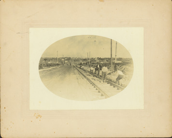
Photograph - Construction of the electric tram line in Riversdale Road, Surrey Hills, E.J. Dower, 1916
One of a series of photographs, taken by Edgar James Dower in the second decade of the twentieth century. Born and raised in Olinda, his family later moved to Surrey Hills. He worked as an adult as a clerk in the city office of the Metropolitan Gas Company, and in his role as a 'collector', he was able to photograph scenes including the construction of tramlines and associated buildings in Kew, Hawthorn, Camberwell and Surrey Hills. Later he established a real estate agency with his brother - the E.J. Dower Real Estate Agency, Dandenong Office.The image is an historically significant record of the development of transport infrastructure which was used to connect Victorians in the first two decades of the twentieth century. This development resulted from increases in population and the consequent extension of Melbourne's suburbs. The photographs, both individually and collectively, richly detail the labour of workers and the tools and machinery used to create and extend Melbourne's tram network in the years preceding and during World War 1.Digital copy of an original oval mounted photograph of the construction of the tracks for the new electric tramline in Riversdale Road, Surrey Hills. Annotated verso: "Preparing for electric tram line, Riversdale Road, Surrey Hills / Taken from near Warrigul [sic] Road / note Essex Road on right with picket fencing."theme --- travelling by tram, theme -- connecting victorians by transport and communications, trams -- boroondara (vic.), riversdale road -- surrey hills