Showing 12220 items matching " reserves"
-
 Greensborough Historical Society
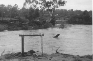
Photograph - Digital image, Plenty River in flood 1972 at Rand Street crossing (3), 1972_
Plenty River in flood Greensborough 1972. There were two major floods in Greensborough at the time, 1972 and 1974. Poulter Reserve was created after the 1972 flood and had to be re-established following the 1974 flood.Digital copy of black and white photograph.plenty river, floods -
 Eltham District Historical Society Inc
Photograph, Eucalyptus Road and Pitt Street/Nyora Road roundabout, Eltham
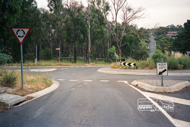
Looking north along Eucalyptus Road, showing roundabout at intersection of Pitt Street and Nyora Road, Eltham. Parks Victoria owns and manages the Pauline Toner Eltham Copper Butterfly Reserve on the left of the image. Colour photographeucalyptus road, pitt street, nyora road, roundabouts, eltham, pauline toner eltham copper butterfly reserve, pauline toner butterfly nature conservation reserve -
 Eltham District Historical Society Inc
Photograph, Eucalyptus Road and Pitt Street/Nyora Road roundabout, Eltham
Looking north along Eucalyptus Road, showing roundabout at intersection of Pitt Street and Nyora Road, Eltham. Parks Victoria owns and manages the Pauline Toner Eltham Copper Butterfly Reserve on the left of the image.Roll of 35mm colour negative film, 4 stripsFuji 100eltham, eucalyptus road, nyora road, pitt street, roundabouts, pauline toner eltham copper butterfly reserve, pauline toner buttefly nature conservation reserve -
 National Vietnam Veterans Museum (NVVM)
Plaque - 8 Signal Regiment plaque
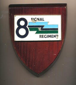
8th Signals Regiment (8 Sig Regt) is an Army Reserve Signal Regiment of the Royal Australian Corps of Signals (RA Sigs) and is a direct command unit of the 2nd Division, Randwick Barracks in Sydney, NSW.Shield-shaped wooden plaque with white rectangular moulded metal attachment, bearing number 8 and a flash shape in green and blue.8 Signal Regiment8 signal regiment, plaque, signal -
 Robin Boyd Foundation
Document, Plan
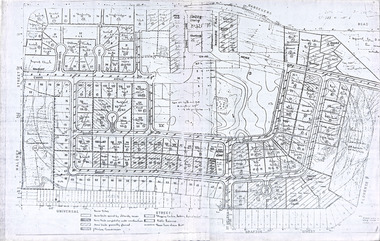
Plan of Eastlakes development NSW (north of Botany) with home units, housing commission, shopping centre and public reserve between Gardeners RD, Universal Street, Grafton Street, Florence Street and Maloney Street.Photocopy, double page taped on reverse. Handwritten and typewritten. -
 Federation University Historical Collection
Photograph - Black and White, Former Ballarat Library, c1960
First known development on this site was the establishment of the Government Camp from the early 1850s. It was established to accommodate officials, troopers and police who were needed to administer the goldfields. Some permanent buildings were constructed. Lack of materials and bad weather prolonged the building of more permanent buildings and most men were still living in tents. Area was known as Camp Reserve. In 1864 a subdivision map shows the reserve be used for Public Buildings. Library applied for land on corner of Sturt and Camp Streets in 1878. 1880s plans show section of the reserve be used for a Free Library and Reading Room. Lease was granted and the old mining boardroom was initially used. Land for additional building to house a Museum and Art Gallery sought and agreement reached in 1882-3. Compensation paid to owners and library granted the land. Plans for a new library building with tower and lantern roof abandoned due to lack of funds. It wasn't until 1895 that a solution to funding was found and the library was able to begin constructing the complex of buildings on the Free Library Reserve. A number of changes have occurred since 1910s - the Classical Revival facade replaced with an angled facade in a stripped Classical style with Art Deco features and high parapet. Building is now part of Federation UniversityPhotograph of former library. Shows a two-storey rendered brick building in a Classical style. Some Art Deco features. Central pair of double windows with single window either side. High parapet above.government camp, goldfields, camp reserve, free library, reading room, sturt street, camp street, museum, art gallery, troopers, police, barracks, camp street -
 Eltham District Historical Society Inc
Photograph, Fay Bridge, Eastern boundary of former Warrandyte Aboriginal Reserve, North Warrandyte, 7 November 2016
Two bronze commemorative plaques on rocks, unveiled by Wurundjeri Tribe Council Elders, mark two eastern boundaries of the former Warrandyte Aboriginal Reserve on the north and south sides of the Yarra. This project was initiated by Nillumbik Reconciliation Group in close association with Reconciliation Manningham and the Wurundjeri Tribe Council, as a means of commemorating the last great corroboree of the Kulin Nation which was held at Pound Bend in March 1852. This plaque is on the Nillumbuk side of the Yarra, accessed via The Boulevard, North Warrandyte. The plaque is set on a rock approximately 50 metres before the turning circle at the end of The Boulevard. Plaque : Warrandyte Aboriginal Reserve This commemorative rock marks an eastern boundary of the former Warrandyte Aboriginal Reserve established in 1852. Centred on Pound Bend, it covered 1,908 acres on both sides of the Yarra River (Birrarung). That same year saw the last great gathering of the Kulin nation here in Wurundjeri country which was celebrated over two weeks with traditional performance and games. For a few years longer the reserve intermittently served as a ration station.With gold having been discovered at Warrandyte, the Wurundjeri were moved on again but ultimately secured a permanent home at Coranderrk, Healesville. A second commemorative plaque and rock is located on the opposite bank of the Yarra and its confluence with Stony Creek. Melway ref : 23 C 9 Unveiled by Wurundjeri Elder, Uncle Bill Nicholson on 23rd March 2013 Funded by the Robert Bridgford Indigenous Trust (Nillumbik Community Fund) with assistance from Manningham City Council Small Grants Program Ref: Monument Autralia https://monumentaustralia.org.au/themes/culture/indigenous/display/99680-warrandyte-aboriginal-reserve-fay bridge collection, 2016-11-07, aboriginal reserve, north warrandyte, plaques, warrandyte aboriginal reserve -
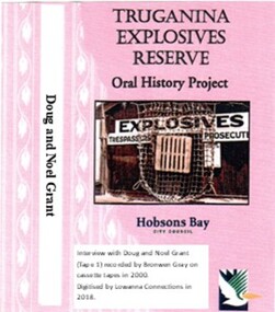 Truganina Explosives Reserve Preservation Society Inc (TERPS)
Digitised Oral History – Truganina Explosives Reserve - Tape 1 Doug and Noel Grant, 2018
The interviews were recorded in 2000 by Bronwen Gray and Alan Young for the production of Unreserved, Stories from Truganina Explosives Reserve, animated stories from past residents, workers and interested people of the Reserve (subject to copyright 2004). Doug and Noel Grant’s Grandfather, Don Grant, was officer in charge of Truganina Explosives Reserve from 1910-1930. On his retirement, his son, William (known as Bill) took over the position until 1956. Along with their two older brothers and younger sister, Doug and Noel Grant grew up, first in the assistant manager’s weatherboard cottage and then in the brick house which was set aside for the officer in charge, until they married and moved into their own homes in their early 1920s. On returning from the second world war, Noel Grant worked as a magazine assistant of explosives on the site from 1946, When the site had closed down in 1962 he worked as an inspector of explosives at the Explosives Branch in Melbourne until he retired in 1985. During that time Noel was asked to move back on site, meaning that three generations of Grants have lived on the site during the twentieth century. Doug Grant worked for ICI/Nobel in head office in 1940 and their older brother Alan worked at the Nobel Explosive Company in Deer Park from 1937. After returning from the Second World War, Alan bought a transport business that had once had the licence to cart explosives in and around the state. They discuss their memories of the living at Truganina Explosives Reserve and the workings of the Reserve, including the names of men who worked there, ships which carried the explosives and life in and around Altona. A primary source of information on memories of the Truganina Explosives Reserve and Altona,VictoriaDigital copy of original cassette recorded in 2000 and digitised in 2018hobsons bay, altona, galvanised iron fence, picket fence, golf course, altona school, margaret grant, bill grant, explosives magazine, lighters, joe hyde, alex grant, pines scout camp, maribynong river, 1896, inspector of explosives, pier, point wilson, werribee sewerage farm, george grant, lighterman, huia, argonaut, pirie, alma doepel, merton street altona, horse, jessie grant, jean grant, sandal, kilmartin, lewis, currie, todd, robinson, balwyn -
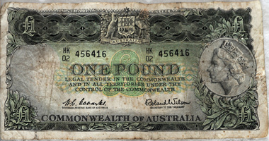 Orbost & District Historical Society
£1 note, 1966
The one pound note was the most prevalent banknote in circulation with the pound series, with the last series of 1953-66 having 1,066 million banknotes printed. The serial number HK 02 suggests it was printed in 1966.this item is an example of pre-decimal currency used in Australia.A green rectangular paper Australian £1 note. On the obverse is the Australian Coat of Arms and a picture of Queen Elizabeth II facing left. On the reverse are Charles Sturt and Hamilton Hume. The signatories are: H. C. Coombs, Governor, Reserve Bank of Australia and Roland Wilson, Secretary to the Treasury. The watermark is Captain Cook in left oval. Behind each signature is ’ONE POUND’. The serial number is HK 456416 02 currency-australia one-pound-note -
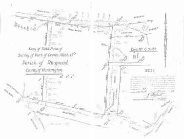 Ringwood and District Historical Society
Document - Copy of Lands Department Field Notes - Parish of Ringwood, Victoria, Field Notes - Part of Crown Allotment 17D Surveyed 1952 (Amended in 1953)
5616b Double foolscap size photocopy of survey map with handwritten notations. References include Corr no. C.93151, Railway Reserve, Station Street, Bedford Road, multiple post & wire fences, multiple galv iron pipes put in, Government Road (Hill Street), Tooronga Road, multiple recent pegs found, Certification 52710 by J. Fitzgerald Licensed Surveyor 17/3/1952. -
Port Melbourne Historical & Preservation Society
Document - Naming of Olive's Corner, Nov 1999
City of Port Phillip instigated the competition re the 'no-name' plaza in October 1999, and the winner was announced 14 Nov at the PMH&PS's 'Lee-ar-day Days' event. Judging panel (Cr Julian Hill, Bruce McKeon and Pat Grainger) met 8.11.1999 to decide winner.Eight pages used in judging the 1999 naming competition for the reserve at Bay and Liardet Streets that through this process became known as 'Olives Corner' (or more formally, Olive Zakharov's corner'). Includes list of entries and copies of all written submissions. Short listing of judges indicated. .09 nomination form to COPP .10 thank you condolence card .11 "Quick reads' newspaper column on Olive's cornerJudge has indicated in green ink the eliminations, finalists etc.parks and gardens, memorials, olive zakharov, julian hill, bruce mckeon, pat grainger -
 Bendigo Historical Society Inc.
Photograph - WES HARRY COLLECTION: BENDIGO LANDMARKS, 1912
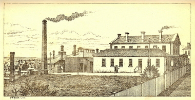
Group of four photographs of Bendigo Landmarks, Taken in 1912. (a) Fountain and Pall Mall, looking East, tram in the centre of the shot and the Hustlers Royal Reserve Poppet head visible to the left, (b) The law Courts with the Conservatory gardens in the foreground, (c) Statue in the Conservatory gardens, (d) shot taken from the tower of Camp Hill School, Rosalind park in the foreground, Post office and Law Courts middle distance.place, bendigo, landmarks, fountain, pall mall, hustlers royal reserve, the beehive, law courts, cons3erveratory gardens, setae, rosalind park -
 Kew Historical Society Inc
Plan - Subdivision Plan, Mount Ida Estate, 1925
The Kew Historical Society collection includes almost 100 subdivision plans pertaining to suburbs of the City of Melbourne. Most of these are of Kew, Kew East or Studley Park, although a smaller number are plans of Camberwell, Deepdene, Balwyn and Hawthorn. It is believed that the majority of the plans were gifted to the Society by persons connected with the real estate firm - J. R. Mathers and McMillan, 136 Cotham Road, Kew. The Plans in the collection are rarely in pristine form, being working plans on which the agent would write notes and record lots sold and the prices of these. The subdivision plans are historically significant examples of the growth of urban Melbourne from the beginning of the 20th Century up until the 1980s. A number of the plans are double-sided and often include a photograph on the reverse. A number of the latter are by noted photographers such as J.E. Barnes.The Mount Ida Estate was a subdivision of fifty-two residential allotments bordering Tooronga Road, Leura Grove, Constance Street, and Mount Ida Avenue in Hawthorn East. The report of the sale of the Estate in The Argus (21 September) claimed that over 1,000 people attended the auction and that all allotments were sold on the day. On the other side of Constance Street, the plan identifies the ‘Eastern Recreation Reserve’ (now Anderson Park).subdivision plans - hawthorn -
City of Kingston
Photograph - Black and white, 5 January 1984
Cheltenham and Heatherton are suburbs in the City of Kingston that were originally established as a rural market gardening community. The market gardens, farms and paddocks have gradually been sub-divided into housing and industrial estates and associated infrastructure such as schools and shopping facilities. This aerial image covers a diverse section of the City of Kingston, taking in the suburbs of Cheltenham, Heatherton, Mentone and Parkdale. By 1984, the market gardens of the district have been replaced by housing and factories. The Nylex factory is visible and now closed. Mentone Bowl on the corner of Warrigal Road and Nepean Highway has now been replaced by high rise apartments, another feature of the changing landscape in the City of Kingston. The vacant land now occupied by the Moorabbin Airport Direct factory Outlet (DFO) is also depicted.Aerial photograph of Cheltenham, Heatherton, Mentone and Parkdale within the City of Kingston. The area depicted in the 1984 aerial view includes Centre Dandenong Road and Cheltenham East Primary School (top left), Kingston Heath Reserve (top right), intersection of Lower Dandenong Road, Warrigal Road, Balcombe Road and Nepean Highway (bottom left), Balmoral Drive/McSwain Street Parkdale (bottom right).White text: 3831-179 Lens information [indecipherable] RINGWOOD M/S 7922-3 RUN 16 [Clockface image] 5,300' ASL VIC DLS© 5-1-84cheltenham, heatherton, mentone, parkdale, market gardens, urbanisation -
 Federation University Historical Collection
Book - Annual Report, Ballarat School of Mines, Ballarat School of Mines Annual Report, 1882, 1872-1882
The Ballarat School of Mines is a predecessor institution of Federation University Australia.Ballarat School of Mines Annual Report. The report includes: Ballarat Gaol Reserve and Endowment, Black Hill (F.M. Krause), Lal Lal Geology (F.M. Krause), Lal Lal Iron Ore Deposits (F.M. Krause) , Sedimentary Rocks of the Ballarat District (F.M. Krause), Skipton Lignite Deposit (F. M. Krause) The report includes the following Images: Ballarat School of Mines and Botanical Garden ballarat school of mines, ballarat court house, ballarat circuit court, skipton, coal, skipton coal, ballarat school of mines botanical gardens, ballarat gaol, w.h. shaw, ferdinand krause, black hill, lal lal, lal lal ore deposits, lal lal geology, sedimentary rocks of ballarat district, skipton lignite deposit, john ditchburn, john o'malley, john thompson mckenna, george samual gawler, henry henry keast, george james, donald mcgregor, george kidd, hachin gordon illingworth, john king, josiah curnow, john james patterson, john bailey bullen, john trevan, thomas james, patrick mcloughlin, patrick murray, john hore, henry ferdinand conrad -
 Glenelg Shire Council Cultural Collection
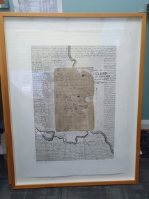
Mixed media - Framed Art Work, Wallace, Carmel et al, Lagoon Page 3, 2004
© Anna Lanyon , Carmel Wallace 2004. Apart from any fair dealing for the purposes of private study, research, criticism or review permitted under the Copyright Act, no text, image or part thereof may be reproduced, stored in a retrieval system, or transmitted in any form, without prior written permission from the authors.This suite of etchings explores the natural and social history of Fawthrop Lagoon, an ancient intertidal lagoon that lies at the heart of Portland on the far south-west coast of Victoria, Australia. The work records and interprets essential moments in the life of the lagoon, the plants, birds, insects, water-creatures and humans who have lived and continue to live around its shores. White card backing with white torn looking inner frame. Centre is print of an extract taken from a survey record of the Fawthrop Lagoon Portland listing the name of the reserve, Allotment number, section number, Township, and Municipality. Markings and dates have been written in. Around the outside of the centre image is hand written wording in fine black ink and a map of the town of Portland also in black ink.4/30 Lagoon, Page 3 Carmel Wallacefawthrop lagoon, portland, victoria, australia, plants, birds, insects, water, creatures, humans -
Bendigo Historical Society Inc.
Document - Hustlers Line of Reef, Bendigo, South Portion, April, 2014
Seven men were killed at the Great Extended Hustler's mine disaster on 2nd May 1914 by an explosion of dynamite occurring as the men were waiting at the plat to ascend the mine at the end of their shift. No blame was attached to anyone in the findings of the inquisition. It was unknown what caused the dynamite to explode. This document formed part of the research done at the time by Bendigo Historical Society, of the 100 years commemoration of the mine disaster, held at Hustler's Hill in 2014. One page photocopy of plan of mining leases on the south portion of the Hustlers Line of Reef. Written underneath plan 'Wood & McNair, Sharebrokers, Beehive Chambers, Bendigo'. Fortuna Hustlers Co., Hustlers Royal Reserve No 2; Great Extended Hustlers Co., Hustlers Reef Co., Hustlers Reef No. 1 and United Hustlers & Redan Co. showing shares held and length of lease are listed on page. great extended hustlers, goldmining, accident, 1873 -
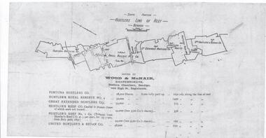 Bendigo Historical Society Inc.
Document - Hustlers Line of Reef, Bendigo, South Portion, April, 2014
Seven men were killed at the Great Extended Hustler's mine disaster on 2nd May 1914 by an explosion of dynamite occurring as the men were waiting at the plat to ascend the mine at the end of their shift. No blame was attached to anyone in the findings of the inquisition. It was unknown what caused the dynamite to explode. This document formed part of the research done at the time by Bendigo Historical Society, of the 100 years commemoration of the mine disaster, held at Hustler's Hill in 2014. One page photocopy of plan of mining leases on the south portion of the Hustlers Line of Reef. Written underneath plan 'Wood & McNair, Sharebrokers, Beehive Chambers, Bendigo'. Fortuna Hustlers Co., Hustlers Royal Reserve No 2; Great Extended Hustlers Co., Hustlers Reef Co., Hustlers Reef No. 1 and United Hustlers & Redan Co. showing shares held and length of lease are listed on page. great extended hustlers, goldmining, accident, 1873 -
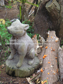
 Eltham District Historical Society Inc
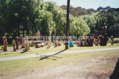
Photograph, Fay Bridge, Leigh Conkie's chainsaw sculptures, Main Road, Eltham, 21 October 2000
These chainsaw sculptures were created by Leigh Conkie at his home in Main Road. There were so many at times it would be a regular sight to see them sprawled across the public reserve adjacent to his home.fay bridge collection, 1305 main road, 2000-10-21, chainsaw sculpture, eltham, leigh conkie, main road -
 Eltham District Historical Society Inc
Photograph, Fay Bridge, Leigh Conkie's chainsaw sculptures, Main Road, Eltham, n.d
These chainsaw sculptures were created by Leigh Conkie at his home in Main Road. There were so many at times it would be a regular sight to see them sprawled across the public reserve adjacent to his home.fay bridge collection, 1305 main road, chainsaw sculpture, eltham, leigh conkie, main road -
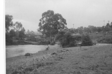 Greensborough Historical Society
Photograph - Digital Image, Plenty River in flood 1972, view at the Rand Street Crossing, 1972_
Plenty River in flood at the Rand Street Crossing. There were two major floods in Greensborough at the time, 1972 and 1974. Poulter Reserve was created after the 1972 flood and had to be re-established following the 1974 flood.Digital copy of black and white photograph.plenty river, floods -
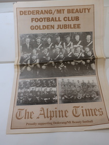 Kiewa Valley Historical Society
Newspaper Supplement - Dederang/Mt Beauty Football Club, Dederang/Mt Beauty Football Club Golden Jubilee
The Dederang/Mt Beauty Football Club held a golden anniversary reunion at the Dederang Recreation Reserve to celebrate 50 years of football and affiliation with the Tallangatta League. Celebrations also included the Bogong and Tawonga football clubs.The Alpine Times 8 page Special Feature Supplement titled the 'Dederang/Mt Beauty Football Club / Golden Jubilee Celebrations' published July 29, 1998. Includes articles and photos.dederang/mt beauty football club, kiewa valley football, bogong and tawonga football clubs, tallangatta football league -
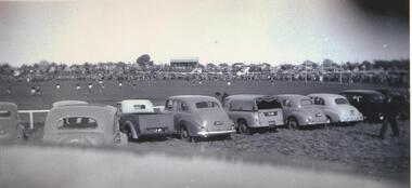 Lake Bolac & District Historical Society
black & white photograph, Football Grand Final at Lake Bolac, 1951
Football Grand Final between Willaura and Streatham teams at the original Recreation Reserve at Lake Bolac, 1951. On the hill in the centre background are the original weatherboard football clubrooms, which were later replaced by a brick building.lake bolac, football grand final, 1951, willaura, streatham -
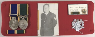 8th/13th Victorian Mounted Rifles Regimental Collection
Medal - WO2 E Roberts
Eric Roberts was an Albury resident who joined 8/13 Victorian Mounted Rifles as a trooper and rose through the ranks to Warrant Officer Class Two. He was awarded the Efficiency Medal and the Reserve Forces Medal.Fabric covered board with two medals, ribbon bar, photograph and 8/13 Victorian Mounted Rifles badge relating to Warrant Officer Class Two Eric Roberts RFM EM.em, rfm, roberts -
 Bendigo Military Museum
Headwear - HELMET, UNITED NATIONS
Helmet belonged to "Gordon Bruce Bearman". Served in the Citizen Military Forces - Nov 1965 to April 1979. Army Reserve Aug 1980 - Oct 1984. Part of this time was spent in Cyprus with United Nations Peacekeeping. Blue painted helmet with United Nations insignia on front. Initials "UN" on right hand side. Inside of helmet is brown in colour. Adjustable webbing is attached with rivets to inside to fit wearer's head. Chin strap missing.On transfer on right hand side "UN" , united nations peacekeeping, uniform, helmet, gordon bruce bearman -
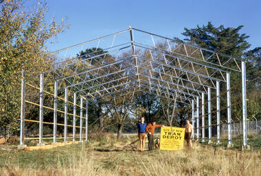 Ballarat Tramway Museum
Photograph - Digital Image - BTPS Depot under construction, Paul Nicholson, 6/5/1972
Photo taken during the work construct the Ballarat Tramway Preservation Society depot in the South Gardens Reserve on 6 May 1972. From left - Paul Nicholson, Bill Jessup, Neville Gower and John Fitzsimons.Yield information about early BTPS activities and the depot construction.Digital image of five BTPS members holding a sign about the work being undertaken.btps, btps depot, construction, ballarat, tramways, tramway museum -
 Kew Historical Society Inc
Plan, J R Mathers & McMillan, 5 Splendid vVlla Allotments,: Segtoune St. & Windsor St., Kew, 1928
Prue Sanderson, in her groundbreaking ‘City of Kew Urban Conservation Study : Volume 2 - Development History’ (1988), summarised the periods of urban development and subdivisions of land in Kew. The periods that she identified included 1845-1880, 1880-1893, 1893-1921, 1921-1933, 1933-1943, and Post-War Development. These periods were selected as they represented periods of rapid growth or decline in urban development. An obvious starting point for Sanderson’s groupings involved population growth and the associated economic cycles. These cycles also highlighted urban expansion onto land that was predominantly rural, although in other cases it represented the decline and breakup of large estates. A number of the plans in the Kew Historical Society’s collection can also be found in other collections, such as those of the State Library of Victoria and the Boroondara Library Service. A number are however unique to the collection.Subdivision plans are historically important documents used as evidence of the growth of suburbs in Australia. They frequently provide information about when the land was sold on which a built structure was subsequently constructed as well as evidence relating to surveyors and real estate and financial agents. The numerous subdivision plans in the Kew Historical Society's collection represent working documents, ranging from the initial sketches made in planning a subdivision to printed plans on which auctioneers or agents listed the prices for which individual lots were sold. In a number of cases, the reverse of a subdivision plan in the collection includes a photograph of a house that was also for sale by the agent. These photographs provide significant heritage information relating house design and decoration, fencing and household gardens.In 1928, five residential allotments bordering Segtoune and Windsor Streets were advertised for sale as part of a subdivision. Four of the blocks faced Segtoune Avenue. The auctioneers proclaimed the advantages of the sites: ‘Situate one minute from the High Street Electric Tram, which now runs direct to Spencer Street via Bridge Road and Flinders Street. Opposite the East Kew Railway Station (Outer Circle Line), which may be reopened In connection with the new Line from Kew to Doncaster; Adjacent lo the Kew Recreation Reserve, Sports Oval, and Swimming Bath; Half Minute from the Shopping Centre of East Kew, Accessible to the State School and Other Educational Centres’. The Harp of Erin Hotel and the route of the Outer Circle Railway line are marked on the plan. The Recreation Reserve and Sport Oval refer to Victoria Park. The Swimming Baths were located on the site of the current Kew Recreation Centre.subdivision plans - kew, segtoune street -- kew (vic.), windsor street -- kew (vic.) -
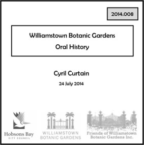 Williamstown Botanic Gardens- Hobsons Bay City Council
Oral History - Williamstown Botanic Gardens - Cyril Curtain, 24 July 2014
The interview is one of a series recorded in 2013-2014 to document memories and experiences of the Williamstown Botanic Gardens Cyril Curtain was born in Williamstown in 1928. He attended North Williamstown Primary School and Williamstown High School. Shortly after marrying he purchased a house on the Esplanade, where he still lives and in which this interview took place. Cyril’s work in conservation of the natural and built heritage is highly regarded. The recently developed Cyril Curtain Reserve in Williamstown is named in his honour. In this interview Cyril discusses the Gardens and the foreshore area including the beach and L A Parker Reserve A primary source of information on memories of the Gardens.CD and transcript of interview with Cyril Curtain and his memories of the Gardens and surrounding environs.fish pond, curator, cannons, williamstown botanic gardens, hobsons bay city council, aviary, pinetum, centennial reserve, midsummers night dream, cable tram car seats, infrared photography, , rotunda, gloucester reserve, 1934 storm, national trust, bateman house, clarke statue -
 Ringwood and District Historical Society
Flyer, Subdivisional Land Auction Sale Brochure, Grand Central Estate, Ringwood, Vic. - 1925
Douglas Street shown in the estate plan did not eventuate, but was developed as a public reserve. Refer also to Reg. No. 5149 for 1924 auction sale of land also titled Grand View Estate situated further north in Ringwood.Double sided multi-folded page advertising public auction sale on Saturday, 31st October, 1925, of residential allotments highlighting local facilities, services and layout of the estate. Includes panoramic view of Ringwood and other local photographic images.Subdivision includes Great Ryrie Street, Heathmont Road, Douglas Street, Garden Street, and Bellevue Avenue. Agents - Knight & Harwood, 315 Collins Street, Melbourne, Phone 10615, 10616 Central, in conjunction with J.B. McAlpin, Opposite Railway Station, Ringwood. Phone Ringwood 7. -
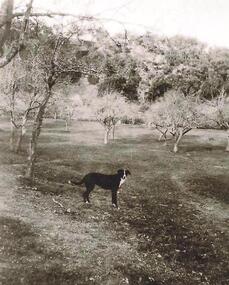 Greensborough Historical Society
Photograph - Digital image, Old orchard at Partington Flat, 1930c
Remnants of the Partington orchard at Greensborough on land that is now the Partingtons Flat reserve in Greensborough. Charles Partington and family came to Melbourne in the 1840s and moved to Greensborough where they farmed along the Plenty River. This dog belonged to Jessie Partington.Digital copy of black and white photograph.partingtons flat, partington family