Showing 31159 items
matching building a
-
 Kew Historical Society Inc
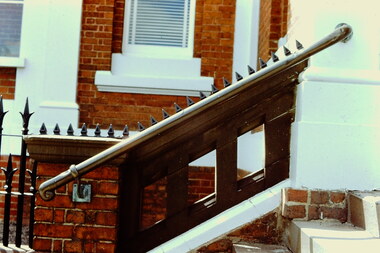
Slide - Stairs: Kew Post Office, 1980
A civic campaign for new public offices developed in Kew in the 1880s. After much deliberation, the location chosen was the junction of Bulleen and Cotham Roads. The buildings were designed by George Watson and John Henry Harvey, architects within the Department of Public Works (Victoria). Building was commenced in 1887, and after one year, the buildings were opened. The Post Office was transferred to the new Commonwealth Government in 1901. The Police Station and Court House, sold by the Victorian Government to the City of Boroondara in 2007, are now a community cultural centre and performing arts venue.The buildings were listed on the Victorian Heritage Register Register (HO885) in 1991. They are historically and architecturally significant to the State of Victoria because Watson and Harvey's designs exhibit diversity in integrating civil offices, they accommodate the apex of road junctions, and they demonstrate a departure from the contemporaneously favoured High Victorian Classical to the Queen Anne style in the design of civic buildings. 35mm colour transparency of the stairs on the left side of the Kew Post Office. The [former] Post Office is a significant example of the English Queen Anne Revival style. The photograph was taken as part of a series by Ralph Andrews (Department of Building, RMIT) in April 1980.kew post office, khs - slides, new public offices -- kew (vic.), architectural styles -- english queen anne revival -
 Kew Historical Society Inc
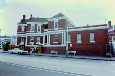
Slide - Kew Post Office, 1980
A civic campaign for new public offices developed in Kew in the 1880s. After much deliberation, the location chosen was the junction of Bulleen and Cotham Roads. The buildings were designed by George Watson and John Henry Harvey, architects within the Department of Public Works (Victoria). Building was commenced in 1887, and after one year, the buildings were opened. The Post Office was transferred to the new Commonwealth Government in 1901. The Police Station and Court House, sold by the Victorian Government to the City of Boroondara in 2007, are now a community cultural centre and performing arts venue.The buildings were listed on the Victorian Heritage Register Register (HO885) in 1991. They are historically and architecturally significant to the State of Victoria because Watson and Harvey's designs exhibit diversity in integrating civil offices, they accommodate the apex of road junctions, and they demonstrate a departure from the contemporaneously favoured High Victorian Classical to the Queen Anne style in the design of civic buildings. 35mm colour transparency of the Cotham Road facade of the Kew Post Office. The [former] post office is a significant example of the English Queen Anne Revival style. The photograph was taken as part of a series by Ralph Andrews (Department of Building, RMIT) in April 1980.kew post office, khs - slides, new public offices -- kew (vic.), architectural styles -- english queen anne revival -
 Bendigo Historical Society Inc.
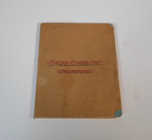
Manual - Set of five manuals: Theory Carpentry, Solid Geometry, Uniform Building Regulations
The donor's father (William Clarence Christopher) was born in 1906 in Williamson Street, Bendigo and was schooled at the Bendigo School of Mines. The notebook on theoretical Carpentry must date from around 1920 when he was an apprentice. His brother James Charles Christopher was a teacher, the Solid Geometry drawings date from 1925-1932 and were submitted by students at Ballarat Junior Technical school. The book od building regulations was used by William Clarence in the 1940's and 50's while employed as a building foreman at Braybrook by Industrial Engineering Ltd.The manuals are covered with brown paper and the title in red or black texter on the front. The theory Carpentry is handwritten, the three Solid Geometry are made up of individual drawings and the Uniform Building Regulations is printed.technical books, school of mines -
 Rutherglen Historical Society
Photograph - Image, 1954 (Approximate)
Centre section of building was built by the original owner, who was of Scottish decent. The two side sections were added by the Burgoynes (later owners), who were French. The different styles of architecture showing the influences of the owners origins.Photograph of Mt Ophir Cellars. The red brick building is in three sections. Five arched double doors. Arched windows. Ventilator on Roof. Pine tree in background. Car in front. mt ophir cellars, mt ophir winery, burgoynes winery -
 Mission to Seafarers Victoria
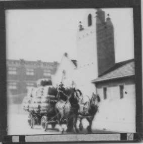
Slide - Glass slide, Black and white, Mission to seamen building, Flinders St and loaded horse-drawn wagon, circa 1920s
This Spanish Mission style building first opened in 1917 and has been in continual use since as the Mission to seamen and later Mission to Seafarers at a location initially known as the extension to Flinders St near the Australian Wharf and later address known as 717 Flinders St. "The Extension Bond and Free stores" building which can be seen in the background can be identified on an aerial photograph of the area dated 1927.This image besides showing an early view of the current Mission to Seafarers building also features a glimpse of the early 20th C (Flinders St) Extension Bond ( Store ?) building positioned to make use of the Yarra-side docks known as the Australian Wharf.Positive photograph on medium format glass slide ; b & w image of the chapel and bell tower of 1917 Mission Building, extension to Flinders St. with a loaded horse-drawn dray or wagon being driven in the foreground. . In the background of image can be seen a section of a large warehouse or Bond store building, visible signage reads: "Extension Bond"in upper case letters. The foreground details appear to have been hand touched up with linear ink highlights. Image is slightly blurry. The slide is edged with adhesive tape.pencil cross at lower right corner on adhesive tape edgingmissions to seamen institute, mission building, extension bond store, warehouse -
 Federation University Historical Collection
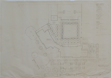
Plan - Plans, Ballarat School of Mines Brewery Building Plans, 1995, 1995
The Ballarat School of Mines Brewery Building is now a part of the Ballarat Technology Park.Site plan and landscape plan for Stage 3 works for the Ballarat School of Mines Brewery Building. .1) Site plan by Philip Cox Sanderson & Partners, Melbourne .2) Landscape plan by John Patrick Pty Ltd, Landscape consultants, Kew, Victoriaballarat school of mines, brewery building, ballarat technology park, john patrick, philip cox sanderson, landscaping, archtectural plans -
 Northern District School of Nursing. Managed by Bendigo Historical Society Inc.
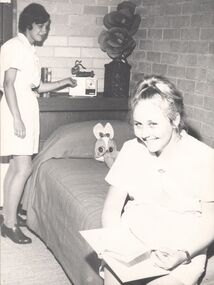
Photograph - Nurses' Home
New hostel at NDSN - new building commenced in July 1968 seated Pauline Smith - Mildura Student. Standing Lois Baker - Castlemaine studentNurses Home (New Hostel) Building commenced July 1968. Black and White Photo of 2 females in nurses uniforms. One is sitting on a single bed and the 2nd nurse is standing at the head of the bed adjusting a radioCopyright - Bendigo Advertiser newspapersnursing history, nursing information, new hostel building -
 Stawell Historical Society Inc
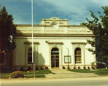
Photograph, Stawell Shire Hall 1866 c1980s -- Coloured
Colour Photo Stawell Shire Hall built 1866, c1980. The Shire Hall is in Longfield Street Stawell and has had many changes since 1866. Ronald Campbell, the Shire's second president laid the foundation of the hall on 28th April 1866. The contractors were Hutchings and Delbridge. The first Hall and office were the front part of the existing building. These rooms consisted of two 18 ft square rooms with an entrance hall separating them. The facade was almost the same as it is today. The building cost 502 pounds.Colour photograph of Stawell Shire Hall 1866. Very similar view to 0084 the photo clearly showing the two windows and arched entrance door. Landscaping outside the building is exactly the same as in 0084. stawell -
 Tarnagulla History Archive
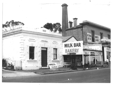
Photograph of milk bar and general store, Tarnagulla, Milk bar and general store, Tarnagulla, circa 1960s-70s
Murray Comrie Collection. This image depicts stores in the main street of Tarnagulla, including the two-storey bank building being used as a licensed general store. The building on the left was also a bank, originally constructed by the Union Bank in 1859, and Is probably the first brick and stone building at Tarnagulla. It was used by the bank until 1888 at which time the Union and Colonial banks amalgamated. After this, the building was used for a variety of purposes. The milk bar section was constructed in the 1920s in an area at the front of what had once been the Bank’s manager’s residence. The Two-story bank building On the right was constructed and used by the Colonial Bank of Australasia (from 1866 to 1888) and, following bank amalgamation, by the Union Bank (from 1888 until closure in 1942). The original site had been occupied by Joseph Foo's store, a large wooden building with attached theatre. While the bank was being built, the Colonial Bank operated from the former Company's Hotel (soon after to become the Borough of Tarnagulla Council Chambers, then the Mechanics’ Institute, and finally, prior to final demolition in 1980, Burstall Hall) The new double-storey building was used by the Colonial Bank from 1866 until 21st February, 1888. The premises were sold to the Union Bank for £2500. The Union Bank moved in and commenced operations on 6th June 1888, continuing until 1942. The building was later used as a general store until the 1990s. It is a now private residence. This is a reasonable copy of an older original. Copy probably made by Murray Comrie in the 1970s. Monochrome photograph depicting a section of Commercial Road, Tarnagulla near the intersection with Poverty Street, including two stores - one a bakery/milk-bar and the other a general store operating in the former Colonial/Union Bank building. Photograph taken from north of milk-bar. Two people walking away from photographer on footpath/curb between the two stores. The building on the left was the Union Bank premises, constructed in 1859 and Tarnagulla's oldest surviving brick building. The Union Bank absorbed the Colonial Bank in 1888, and the Union Bank moved operations next door into the much larger former Colonial Bank premises which had been constructed in 1865/66. After amalgamation, the old Union Bank premises was then used for a variety of purposes from visiting doctor's rooms to cafe, etc. The Union Bank continued to operate at Tarnagulla until closure in 1942, at which time business had fallen away and Tarnagulla Branch had already been downgraded to sub-branch status. tarnagulla, banks, banking, commerce, stores, shopping, shops, food, groceries, buildings, commercial road -
 Federation University Historical Collection
Photograph, 4 Photographs of Painting of old Gaol Building
Old Gaol building is apart of the School of Mines Campus of Federation UniversityFour photographs of painters painting the old Gaol Building .1 3 painters in different positions doing painting .2 2 painters one on ladder painting around window .3 2 painters one standing on the fence .4 4 painters painting.painters, gaol building, school of mines ballarat, federation university, painting, painting gaol building -
 Buninyong & District Historical Society
Photograph - B/W photograph, St. Alban's Cottage c 1873, former home of Dr. Sparling, July 1993
Built around 1873 by Dr. Sparling, on land formerly occupied by the first Buninyong Inn (aka Jamieson's Hotel). Some materials from the demolished hotel may have been used in building the house.Good example of 1870's professional residence, links to prominent citizen Dr Sparling.B/W Photograph, Polychrome brick cottage, L-fronted with bullnose verandah, on bluestone foundations with low bluestone fence. Signs "Buninyong Antiques" (under verandah) and "Antiques" on front of building.buninyong, sparling, jamieson, house, brick -
 Linton and District Historical Society Inc
Photograph, Bank of New South Wales, Sussex Street, Linton
Black and white image within a grey cardboard mount. Image is of a brick building with a picket fence. The building was originally the Bank of New South Wales building built between 1903-1904. The building in now a private residence.buildings, banking, bank of new south wales, linton -
 Sunbury Family History and Heritage Society Inc.
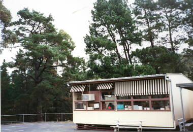
Photograph, Bulla Primary School - Portable classroom, c1990s
The building was one of the classrooms brought to the Bulla Primary School in the early 1990s to accommodate the increased school enrolments. These rooms were easily transportable and were uses extensively in Victorian Government schools from the early 1950s onwards to cope with growing school attendances. A non-digital photograph of a weatherboard building with a low pitched metal roof and brown and white striped sun-blinds erected in an open ground with tall conifer trees in the background.bulla primary school, portable classrooms -
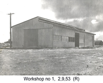 Glenelg Shire Council Cultural Collection
Photograph - Photograph - Portland Harbour Trust - Workshop No. 1, 1953
Port of Portland Authority archivesFront: (no inscriptions) Back: P.H.T./ Print No. 3/22 Neg. No 170/ Date taken 2.9.53./ SUBJECT./ Workshop No. 1. (Ink stamp with blue pen and pencil additions, centre) Partial fingerprint in purple ink, lower centre.port of portland archives -
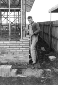 Slovenian Association Melbourne
Photo, Lojze Markic: building site
At the building site -
University of Melbourne, Burnley Campus Archives
Photograph - Black and white print, 680/17
Administration Building.administration building, e. m. gibson collection -
 University of Melbourne, Burnley Campus Archives
Photograph - Colour print, Engineering Building
The Engineering Building.engineering building., burnley -
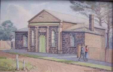 Glenelg Shire Council Cultural Collection
Painting, Portland Town Hall, c. 1955
Portland Town CouncilPainting of a bluestone building with four columns mounted decoratively on the front of the building. A footpath is in front of the building, with a man and woman walking. A dirt road curves from foreground centre towards and past the building to the left. Two tall pines are behind the building on right. Building bears sign reading "Town Hall 1869". Framed under stippled glass in wooden frame.Front: Town Hall Portland '55 (brown paint, lower let). Travis Webber (brown paint, lower right). Back: Geelong Picture Framers, 211 Moorabool Street, GEELONG. Ph. 97805 (blue ink stamp, lower centre). -
 Eltham District Historical Society Inc
Ledger, Eltham Road District. Assessment for the Year ending Oct. 14th, 1861, 1860c
The Eltham Roads Board was established in 1856. This is a unique significant record of early settlers in the Shire of Eltham. One of 6 early rate books. This is among the oldest items in the EDHS collection. An article in the Eltham and Whittlesea Shires Advertiser Friday 21 Nov 1941 Page 5 titled: District's Early History states: "The first rate book which is still in existence at the Shire Office is for the year ending October 14, 1858 and is probably the best record possible to indicate the development of the district. At the time properties were rated as follows: Cultivated land. 6d. per acre; pasture land, 1d. per acre: estimated annual value of buildings, etc., 6d in the (pound). The total amount of rate recorded for the year was (pounds)153/14/8. Properties were described as being situated at Lower Plenty, Yarra Yarra, Eltham, Lower Eltham, Kangaroo Ground, Yarra Flats, Diamond Creek and the Yarra."Ledger with printed columns: Number, Name of Occupier, Description, Where situated, Cultivated land, Pasture land, Estimated annual value of buildings, Rate, Remarks, Arrears collected, excused, unoccupied, uncollected and amount actually collected. Ledger filled out by hand with 185 entries (not alphabetically arranged) and summary section. A number of blank pages are included. Inside cover includes pasted printed note: RATE OF ASSESSMENT AS FOLLOWS: Cultivated land 6d per acre Pasture land 2d per acre Unalienated Pasture Land 8d per Acre Estimated Annual Value of Buildings, &c., 6d. in the Pound eltham roads board, rate book, rate payers, transaction, pioneers, settlers, 1861, assessment ledger, eltham road district, public records office victoria (prov), rate books, shire of eltham archives -
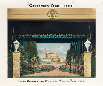 Bayside Gallery - Bayside City Council Art & Heritage Collection
Photograph - hand-coloured photograph, Brighton Centenary Year, Stage decoration, Mayoral Ball, c. 1959
This work was presented to The Mayor and Mayoress, Cr. and Mrs R.G. Ward, by the citizens of Brighton to commemorate the Brighton Centenary in 1959. Brighton was first incorporated as a borough on 18 January 1859, it became a town on 18 March 1887 and was proclaimed a city on 12 March 1919. The new Brighton Municipal Offices were designed by Kevin Knight of Oakley and Parkes with the engineers John Connell and Associates and were erected by Prentice Builders Pty Ltd. The foundation stone was laid on 13 February 1959 and the building was opened on 21 July 1961. The interior decoration and furniture was by Grant Featherston.brighton centenary, brighton town hall, stage decoration, mayoral ball, brighton municipal offices, civic centre, oakley and parkes, kevin knight, r.g. ward, mayor -
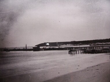 Glenelg Shire Council Cultural Collection
Photograph - Photograph/Postcard - View of Portland Harbour, View of Portland Harbour, n.d
Displayed at History House.Black and white photo. Images shows bare Battery Point, buildings under cliff, pier with building at end , another building (Baths?) and uprights in ocean.Front: View of Portland Harbour Back: State Library of South Australia, Photographic Section. Reproduction prohibited except with the permission of the copywirte holders. Order No. A/6493 -
Glenelg Shire Council Cultural Collection
Document - Handwritten Note, 25/09/1992
Handwritten note from Frances Hall of the Historic Buildings Council to Vanda Savill, accompanying brochures and application forms for adding a building to the Historic Buildings register.Back: '4.2 square cottage original sandstone cottage' - handwritten, red biro -
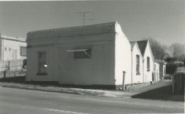 Kilmore Historical Society
Photograph, 83 Sydney Street
14cm x 9 cm black and white photograph of the building on 83 Sydney Street. The building is a light coloured corrugated iron building with angled roofing. Written on the back: 83 Syd 124 -
 Mission to Seafarers Victoria
Slide - Glass slide, Black and white, circa 1921
This image provides an additional later modified building view to that of the image of the original single storey building image published on back page of the 1910 MTS Annual Report. According to the Annual Report of 1915 the plans to build a residence on top ( the 2nd storey ) of the Port Melbourne building got the go ahead to commence and opened 1916. Originally designed by architect, Frederick Williams, who built the first brick Mission at Port Melbourne in the 19th C. Walter Butler was commissioned for the second storey.The Port Melbourne building in the image established in the 19th C., still survives. It was a key centre of operations for the Mission prior to the building of the Mission near Australian Wharf in 1907 and prior to the eventual opening of the current "Central Mission" in 1917. NB operations of The Port Melbourne Branch Mission were eventually transferred to the King George V memorial Building, dedicated in December 1937 but demolished in 1995. The Mission depicted here still survives as part of an apartment complex on the corner of Nott st.Positive photograph on medium format glass slide ; b & w image of brick building taken from a corner street level view, with upper storey at one end on glass transparency with a flagpole and flag (Flying Angel) just discernible. The slide is edged with adhesive tape.missions to seamen institute, mission building, frederick williams, walter butler, port melbourne, beach road, mission to seafarers, nott street -
Clunes Museum
Photograph - PHOTOGRAPHS
.1 The netball court in the photo was where "Collins Place", Fraser Street, Clunes is now located .3 the warehouse/Clunes Museum building at 36 Fraser Street, Clunes, was a former freezing worksPhotocopies of photographs .1 2 copies of girls playing netball .2 A streetscape of Fraser Street, Clunes .3 Del Mayberry (nee Campbell) and friend. The building that is now the warehouse/Clunes Museum is in the background of this photo, the building was a former freezing works .4 Jean Harling (nee Campbell) and male friend, outside The Club Hotel, Fraser Street, Clunes .5 Landscape of Clunes looking towards Station Flat Road. Port Phillip Mine is in the backgroundcampbell, netball, mayberry, harling -
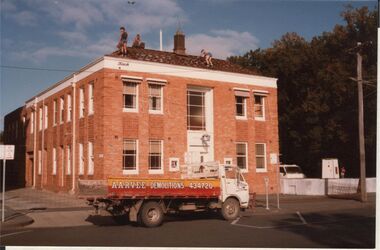 Bendigo Historical Society Inc.
Photograph - POLICE HEADQUARTERS, BULL STREET BENDIGO
Colour photo: two storey cream brick police headquarters building, tile roof. Situated alongside Court House building in Bull Street, Bendigo. Parked in front of building 'Arvee Demolitions' tray truck. Men on roof of police building, removing tiles. Building in early stages of demolition.organisation, government, police -
 Eltham District Historical Society Inc
Photograph, View looking up 'Policeman's Hill' on Main Road from Dalton Street showing Police Residence, c.1906, 2010c
For original image see EDHS_00533 This photo was originally mounted on 3mm MDF fibre board with notes and stickers applied as part of a display on the former Police Residence and now present day Local History Centre, home to Eltham District Historical Society; possibly put together by Harry Gilham during his time as president of the society. Eltham Police Station and Residence: A brief history 1860 Eltham Courthouse built in Main Road, together with an adjoining police residence, office, lock–up and stables. 1959 Police Department purchases a house in Pryor Street to be refurbished as Eltham Police Station 1961 Police in Eltham move into Pryor Street refurbished buildings and office. c.1961-1981 Occupied by Vermin and Noxious Weeds Destruction Section of the Department of Crown Lands and Survey. Former Police Station dragged around to rear of Police Residence (prior to August 1967) to make way for the construction of a driveway and access from Main Road. The building was placed on the site of a former Scullery and modified for Lands Department use. 1981 Shire of Eltham take over management of old Police Residence in Eltham. It remains unoccupied for a period of time whilst its future is discussed in Council. 1981-1985 Used for community job creation scheme 1985 Shire of Eltham Parks and Environment occupy the residence. Council improve the driveway but later add a second rear access from Brougham Street due to the dangerous nature of the Main Road entrance. Also add a rear toilet facility between the Police Residence and former Police Station, which was doubling up as a lunch room. Council also commence discussions to re-establish a replica Police Station. c.1986 November. Former Police Station demolished; believed to have been suffering termite damage. c.1989 After some years of discussion a replica Police Station is built, based on photographs, to act as a lunch room and meeting room for Parks and Environment staff and volunteers doing community service. 1996 Eltham District Historical Society in discussions with Nillumbik Shire Council commisioners throughout the year regarding a home for the Society. A proposal put forward by the Society in October to occupy the former Police Residence. 1997 March. Eltham District Historical Society gains access to former Police Residence. 1998 July 12th. Eltham District Historical Society Inc moves into its Local History Centre, 728 Main Road Eltham (the former Police Residnce built in 1860). 2018 July. Eltham District Historical Society gains access to the replica Police Station for use as part of regular heritage tours for schools and community based groups.Black and white photocopyLabels and handwriting in pencil and ink identifying various buildings. Also highlighted is the acetylene gas lamp and on reverse is written "Lamplighter Jimm Saville"728 main road, eltham, local history centre, parks and environment, police residence, police station, shire of eltham -
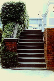 Kew Historical Society Inc
Slide - Stairs: Kew Post Office, 1980
A civic campaign for new public offices developed in Kew in the 1880s. After much deliberation, the location chosen was the junction of Bulleen and Cotham Roads. The buildings were designed by George Watson and John Henry Harvey, architects within the Department of Public Works (Victoria). Building was commenced in 1887, and after one year, the buildings were opened. The Post Office was transferred to the new Commonwealth Government in 1901. The Police Station and Court House, sold by the Victorian Government to the City of Boroondara in 2007, are now a community cultural centre and performing arts venue.The buildings were listed on the Victorian Heritage Register Register (HO885) in 1991. They are historically and architecturally significant to the State of Victoria because Watson and Harvey's designs exhibit diversity in integrating civil offices, they accommodate the apex of road junctions, and they demonstrate a departure from the contemporaneously favoured High Victorian Classical to the Queen Anne style in the design of civic buildings. 35mm colour transparency of the stairs on the right side of the entrance to the Kew Post Office. The [former] post office is a significant example of the English Queen Anne Revival style. The photograph was taken as part of a series by Ralph Andrews (Department of Building, RMIT) in April 1980.kew post office, khs - slides, new public offices -- kew (vic.), architectural styles -- english queen anne revival -
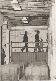 Rutherglen Historical Society
Image, Olive Codling
Some of the buildings of the Mount Ophir winery. Photo was taken by Miss Olive Codling, who was a life member of the Wodonga Historical Society. Photograph is believed to have been taken on the occasion of a Tour by the North East Branch, 1st combined meeting.Black and white photograph of several people walking across a raised walkway in a building with rough textured walls, and stained timber ceiling beams. There are two rows of wine barrels in the foregroundmt ophir, mount ophir, wine industry -
 Yendon History Group
Framed pen and ink sketch of Yendon station, Mervyn Hill, 2010
Sketch was done as a sample of the artist's work when a drawing was sought to be the picture of the station on the interpretive sign planted at Yendon station. Although this is an excellent interpretation of the station building, it was thought to be too detailed for the purpose.Pen and ink detailed drawing of Yendon station building, with 2 people standing on the platform. Frame is timber, 50mm wide, mat black, with an 8mm silver trim around the cut-out hole.Signed by Mervyn Hill at the bottom right hand corner.yendon railway station, hill, mervyn, ink drawing