Showing 10954 items matching "land "
-
 Whitehorse Historical Society Inc.
Map, Map of Vermont area, c1895
Photocopy of part of a larger map showing the Vermont area.Photocopy of part of a larger map showing the Vermont area. Note on side 'after 1892'. Shows land holders.Photocopy of part of a larger map showing the Vermont area.maps, vermont -
 Ringwood and District Historical Society
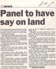
Newspaper, Scrapbook Clipping, Library Collection, Ringwood, Victoria
Newspaper Clipping from "The Mail", 3-10-95. P23. By Andrew Meath. Panel to have Say on LandAn independent panel will decide whether a housing subdivision in an environmentally sensitive part of North Ringwood should proceed. The Ministry of Planning and Development will appoint the panel to consider a request from developers of Barnsdale Forest to divide one acre (0.4 hectares) parcels of land into 7 lots -
Whitehorse Historical Society Inc.
Book, Sevenoaks Park, 1980 repr. 2004
A history of Jeffery Street Blackburn and surrounding area once known as Sevenoaks Park.A history of Jeffery Street Blackburn and surrounding area once known as Sevenoaks Park. Contains old maps and land titlesA history of Jeffery Street Blackburn and surrounding area once known as Sevenoaks Park. sevenoaks park, jeffery, mary ann, jeffery street blackburn, blackburn road blackburn, lake road blackburn, da costa, robin, burns, frank, satchwell, keith -
Whitehorse Historical Society Inc.
Document, Certificates of Title - Arthur Royle & Robert Driver Thurgood, 1931, 1934
Certificate and TitleCertificate and Title for house and land off L.L. Vale Road, Vermont and correspondence re outstanding rates.Certificate and Title shire of blackburn and mitcham, rates, land titles, royle, arthur, thurgood, robert driver, boronia road, vermont -
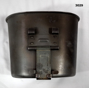 Bendigo Military Museum
Equipment - MUG, post 1960
The Army terminology for this item is, “Cups canteen steel”Mug, stainless steel, kidney shaped with metal foldout handle.“US Landers ..........”military history - equipment, mug, cup, equipment -
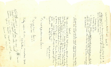 Beechworth Honey Archive
Hand-Written Copy of Particulars of Sale of Land July 1918
Hand-written copy of a Particulars of Sale of Land. Frost selling on behalf of Elizabeth Ann Larkin to Beatrice May Hussey. £120. Written in black ink on paper.hand written, hand-written, particulars, sale, land, frost, larkin, hussey, beekeeper, beechworth honey -
 Greensborough Historical Society
Photograph, Keith Willimott, Willimott photographs, 1956-1964
8 photographs of construction of Willimott home, High Street Watsonia. Includes sale advert for land (The Age 1956)Photographs to accompany Willimott family oral history.Copy of group of black and white photographs. Copy of one newspaper advertisement for a block of land. 3 pages.Captions on back of each photograph.willimott family, watsonia, oral history -
 Greensborough Historical Society
Map, Gary Partington, Alwyn at Whatmough Park, 1960s
The property "Alwyn" was owned by the Partington family and was compulsorily acquired by the Shire of Diamond Valley to become Whatmough Park. This plan was drawn from memory by Gary Partington and illustrates land use when his father, Alan Partington, owned the property.This plan illustrates the rural nature of land around Greensborough prior to the 1960s.Drawing of land use in 1960s at "Alwyn", a property currently occupied by Whatmough Park alwyn, partington family, whatmough park -
Whitehorse Historical Society Inc.
Letter - Correspondence, St Edward's Church of England, 1/03/1963 12:00:00 AM
Letter forwarded with cheque from W.B. Wicking to St Edward's Church of England, Blackburn SouthLetter forwarded with cheque from W.B. Wicking to St Edward's Church of England, Blackburn South as a loan to purchase 2 blocks of land.Letter forwarded with cheque from W.B. Wicking to St Edward's Church of England, Blackburn Southst edward's anglican church, blackburn south, wicking, walter benjamin -
Whitehorse Historical Society Inc.
Article, School Site Too Costly
Whitehorse Council has rejected an offer to buy the former Nunawading Primary School site.Whitehorse Council has rejected an offer to buy the former Nunawading Primary School site but will continue to lobby the State Government to preserve the land.Whitehorse Council has rejected an offer to buy the former Nunawading Primary School site. city of whitehorse, nunawading primary school no.4190, springvale road, nunawading no.96 - 106 -
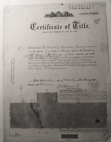 Tatura Irrigation & Wartime Camps Museum
Document, Certificate of Title Edward Baldwin
Certificate of title and corresponding copies of information relating to the purchase of land by Edward Baldwin of Kyneton. Vol 2919 folio 5836823 A4 pieces of paper with photocopied copies of certificate of title and two other documents relating to purchase of land.edward baldwin, certificate of title, vol 2919 fol 583682 -
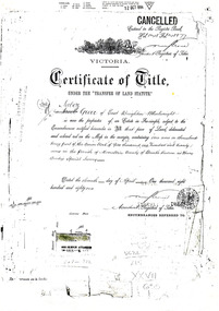 City of Moorabbin Historical Society (Operating the Box Cottage Museum)
Document - Photocopy of Land Title 1881, c1881
This is a Certificate of Title for an acre of land in 'Tucker's Road' purchased by Jabez Gurr in 1881, in the area that was part of the Crown Block known as Henry Dendy's Special Survey 1841, in the Parish of Moorabbin, County of Bourke, Victoria. Following the 'Transfer of Land Statute' allotments in the area of Henry Dendy's Special Survey of 1841 were sold to early settlers. This Certificate of Title shows the passage of history in Moorabbin Shire . Jabez Gurr, a wheelwright, of East Brighton, now Bentleigh East, purchased an acre of land in 'Tucker's Road' , near Centre Road, in 1881. In 1889 he sold to a produce merchant, Robert Smith, and in April 1916 this block was purchased by William Henry George Box, a market gardener and relative of William and Elizabeth Box, who owned the land until 1926. The land was then purchased by Charles John Greenlaw Coates and remained with this family until 1971. All these Family names appear on Councils and Community Boards during the foundation and development of City of Moorabbin3 photocopied pages of the Certificate of Title for approximately 1 acre of land near the corner of Centre Road and Tucker Road, Parish of Moorabbin, County of Bourke, Victoria that was part of the 5,120 acre Henry Dendy Special Survey in Brighton in 1841 and purchased in 1881 by Jabez Gurr. It records subsequent proprietors up to 1971Stamped CANCELLED 12 OCT 1994 (top Right) / Entered in the Register Book / Vol.1245 Fol. 248877/ signed Henry Crowe / Assistant Registrar of Titles / Coat of Arms / VICTORIA / Certificate of Title / UNDER THE ' TRANSFER OF AND STATUTE' /dated ' eleventh day of April one thousand eight / hundred and eighty one' / signed 'Henry Crowe' / Assistant Registrar of Titles/ ENCUMBRANCES REFERRED TO / circular Stamp 'OFFICE OF TITLES VICTORIA' / Drawn and shaded on the left side is the area of land in "Tucker's" Road 3331/3 links fro Centre Road, 150 links x 6662/3 links / The measurements are in linksdendy henry, dendy's special survey 1841, brighton, moorabbin, bentleigh, market gardeners, early settlers, pioneers, wheelwrights, merchants, fruit gardens, markets, smith robert, box william henry george, gurr jabez, county of bourke, victoria, melbourne, land statutes, tucker road, centre road, box william, box elizabeth, box cottage museum -
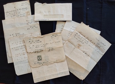 Mont De Lancey
Document - Land Receipts, M. H. Proctor, H. Proctor & W Hunter, 1946 - 1951
These are handwritten land receipt documents between Maxwell Proctor and W. Hunter (owner) 1946 - 1951 and between M.H. Proctor and H. Proctor 1947, 1948 and 1949.Two sets of handwritten land receipts in a used envelope with blue type at the bottom: Chamber of Manufactures Insurance Ltd. The first set of three receipts are written in copperplate handwriting for Mr. M. H. Proctor and are for the purchase of land, from W. Hunter (owner of the land). They are dated Feb 28th 1946, 17th April 1951 and an indecipherable date o the last one. The second set of six handwritten receipts are from M. H. Proctor to H. Proctor for land purchased: May 27th 1947, Dec 7th 1947, June 22nd 1948, Dec 14th 1948, May 30th 1949 and Dec.6th 1949. All letters are handwritten with a small green or yellow 3d. official Stamp Of Victoria glued to them. They are all signed by W Hunter or H. J. Proctor.legal documents, documents, land sales, contracts -
Whitehorse Historical Society Inc.
Article, Farm digs in against closure, 2013
Land reserved for Healesville Freeway is at risk of being broken up for housing.Land reserved for Healesville Freeway is at risk of being broken up for housing. Some of the area is used at present for a farm run by NADRASCA, and other land is the nature reserve, Bellbird Dell. More than 1500 protested against the closure to local MP Shaun Leane.Land reserved for Healesville Freeway is at risk of being broken up for housing. healesville freeway reservation, bellbird dell, nadrasca, leane, shaun, vermont, koedyk, gus, turner, raeoni, kayne, rodney, basic, peter, vicroads -
Clunes Museum
Document - DOCUMENT - COVENANT, PRIMITIVE METHODIST CHAPEL
LAND TO BUILD PRIMITIVE METHODIST CHAPEL ONCOVENANT BETWEEN TALBOT LAND BUILDING INVESTMENT SOCIETY AND THE PRIMITIVE METHODIST CHAPEL IN CLUNES DATED 29/05/1877 FOR ALLOTMENT 12 SECTION 6.primitive methodist chapel, talbot land building and investment society -
 Kew Historical Society Inc
Legal record - The Indenture, Crown Portion 86, otherwise known as 'The Morgan Deed', 1852 (and later)
This indenture once formed part of the City of Kew's Municipal Collection. Cr. W.D. Vaughan in his history 'Kew's Civic Century' (1960) records on page 194 that: "The original deed of conveyance of the land being all of Crown Portion 86, Kew, purchased by John Quick, James Venn Morgan, Samuel Derrick and William Derrick was presented by the Historical Society of Victoria on behalf of Mrs Fryer, a daughter of the later J.V. Morgan, to the [Kew] Council on August 5, 1941. Crown Portion 86, comprised all the land between Cotham Road and High Street to an alignment opposite the east boundary of Glenferrie Road. On it the first residential house was built by Mr. J.V. Morgan in 1852." Following the donation, the Indenture was surrounded by other original related text and explanatory notes and framed. The resulting framed documents are the largest framed objects in the collection.The Indenture and the accompanying contextual documents are some of the most historically significant manuscripts to have survived since the settlement of Kew in the 1850s. They provide a link to Kew's most famous pioneering families.Framed 1952 Indenture recording the sale of land in Kew to pioneering Kew families.james venn morgan, john quick, william derrick, samuel derrick, kew (vic) - history, kew (vic) - pioneers, samuel watts, kew (vic.) — municipal collection -
Whitehorse Historical Society Inc.
Article, Antonio Park Primary School, 1958
Article detailing dealings between Education Department, Nunawading Council and Mr. AntonioArticle detailing dealings between Education Department, Nunawading Council and Mr. Antonio regarding acquisition of land for a State School on site of Antonio Park.Article detailing dealings between Education Department, Nunawading Council and Mr. Antonio antonio, e., antonio park, mitcham, antonio park state school, city of nunawading, victoria. education department -
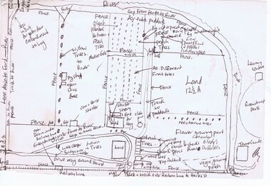
Whitehorse Historical Society Inc.
Document, Healesville Freeway Reservation Renewal Project, 2012
Agenda of meeting between VicRoads and Whitehorse Historical Society 1 Feb 2012.Agenda of meeting between VicRoads and Whitehorse Historical Society 1 Feb 2012, with supplementary documentation of boundaries, project purpose, and current land useAgenda of meeting between VicRoads and Whitehorse Historical Society 1 Feb 2012.forest hill, vermont, vermont south, healesville freeway reservation, vicroads -
Whitehorse Historical Society Inc.
Document, William James Moffatt, 1866-1945
Information about William James Moffatt, an orchardist in Mahoneys Road, Burwood East.Information about William James Moffatt, an orchardist in Mahoneys Road, Burwood East, after purchasing land there in 1907 and until his death in 1945.Information about William James Moffatt, an orchardist in Mahoneys Road, Burwood East. moffatt, william james, orchardist, orchards, mahoneys road, burwood east, moffatt, ian -
Stawell Historical Society Inc
Badge - Realia, IOOF Victoria Australia
Membership badge for International Order of Oddfellows. Victoria AustraliaEnamelled Badge. Gold wings on top over blue with IOOF and Chain over top. Red Enamel outer with Victoria Australia?land and King Melborne -
 Bendigo Historical Society Inc.
Document - LANDS OFFICE : TANDARRA ESTATE, COUNTY OF BENDIGO, 1906 - 1920
Document: green bound hard cover journal with red spine binding and corners. On spine ' Tandarra' written in black. Journal contains details of allotments leased in the Tandarra Estate. Maps and letters relating to blocks are enclosed. LH page: details of lessee, improvements (year range 1906 - 1920) , RH page: residence, population, results of cultivation, stock etc., remarks re lessee's gains or losses each year.Land and Survey Officerland leases, tandarra, bendigo, sandhurst, lands office, land settlement -
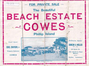 Phillip Island and District Historical Society Inc.
Brochure, Beach Estate Cowes, c 1940's
Advertising Land for Sale in Cowes, Phillip IslandFour page colour Brochure advertising land in Devon Avenue and Cornwall Avenue, Cowes, For Sale. Illustrations of Cowes Pier, The Beach at Cowes and motoring on the Island.Four pages of Real Estate lingo!! Agents - Chas Grayden Jnr, Cowes and Duncan & Weller, Malvernreal estate, cowes phillip island, charles grayden jnr., cowes, duncan & weller, malvern & canterbury -
Whitehorse Historical Society Inc.
Map, Subdivision of Allotment 122a, 1972
Subdivision of land along Livermore Close and Moore Road, Vermont South.Subdivision of land along Livermore Close and Moore Road, Vermont South. Original survey Rob Poole 1899. Stamp indicates 'Land on this plan is in proclaimed survey No 21. Survey Coordination Act 1940. As from 9 Aug 1972. Two maps in different scales.Subdivision of land along Livermore Close and Moore Road, Vermont South. land subdivision, livermore close, vermont south, moore road, vermont south, dandenong creek -
Whitehorse Historical Society Inc.
Article, Winlaton faces closure, 1993
Winlaton, now known as Nunawading Youth Residential Centre will close and relocate.Winlaton, now known as Nunawading Youth Residential Centre will close and relocate to the Baltara Reception Centre in Parkville and the remaining 8.4 ha land will be sold.Winlaton, now known as Nunawading Youth Residential Centre will close and relocate.youth services, winlaton, nunawading youth residential centre -
 City of Moorabbin Historical Society (Operating the Box Cottage Museum)
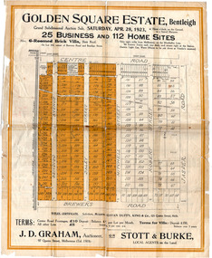
Flyer - Golden Square Estate, Bentleigh, 1923
Land sales in the Municipality of Moorabbin increased when the train line from the City to Frankston was electrified.Example of the progress of the Municipality of MoorabbinThe train line from the city to Frankston was electrified which intensified the sale in the municipality of Moorabbin, particularly land which was in the vicinity of the railway stations.Golden Square Estate, Bentleigh - J. D. Graham, Stott & Burke - 25 business sites and 112 home sitescentre road, brewers road, jasper road, robert street, mitchell street, daley street, bendigo avenue, auction, real estate, moorabbin, bentleigh -
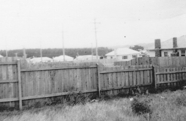
 Ballarat Heritage Services
Photograph - Colour, Clare Gervasoni, Borsa Crescent, Hepburn Springs, from Bellinzona, 2004, 28/06/2004
The block of land depicted has been leveled with a huge rock barrier around the corner perimeter.Block of land on the corner of Borsa Crescent and Seventh Street taken not long after Bellinzona and Wanda Inn had been burnt down.bellinzona, actea, hepburn springs, church avenue, seventh street, borsa crescent, wanda inn, fire -
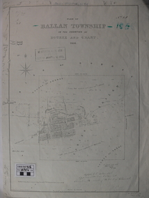 Ballan Shire Historical Society
Map - Map. Ballan Township, Plan of Ballan Township in the Counties of Bourke and Grant
The map is an early one of the township of Ballan showing street names and land owners.The map is significant in that it lists the owners of the house blocks within the township.A map showing the township and surrounding area of Ballan in 1856. Town streets are named as are the owners of the subdivided blocks of land. The map is a lithocopy and there is a scale in chains."D D Fraser" is written across the top of the map and "1856" is written in the near top right corner. There are other additions to the map but they are very difficult to decipher accurately or completely.ballan, ballan township map, ballan1856 -
4th/19th Prince of Wales's Light Horse Regiment Unit History Room
Pamphlet, Royal Australian Armoured Corps Advanced Signal Training 1981, 1981
Used by the RegimentSoft covered loose leaf book, the RAAC extract from the Manual of Land Warfare Part Two, Signal Training Volume 2 detailing communications techniques and radio telephone proceduresRoyal Australian Armoured Corps Advanced Signal Training. RAAC extract from the Manual of Land Warfare Part Two, Signal Training Volume 2 Communications Techniques Pam No 3 Telephone Procedures (All Corps) 1980signals training, royal australian armoured corps, handbook -
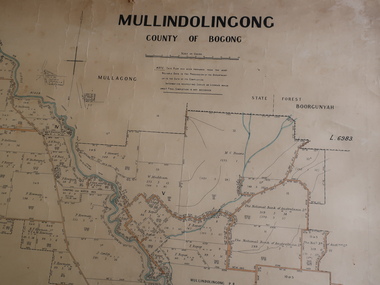 Kiewa Valley Historical Society
Parish Map - Mullindolingong, County of Bogong
The Department of Lands regularly updated the occupiers with leases or licences of the land.The names of the early settlers of the Kiewa Valley occupying land by lease or licence are shown. Many of these familie's descendants still live in the Kiewa Valley.Government (Lands Department?) cloth map showing the leases or licenses of occupiers of the land in the valley. The Kiewa River is shown in blue and roads in yellow. There is no date on the map.parish of mullindolingong map, settlers of the kiewa valley -
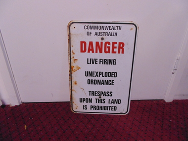 National Vietnam Veterans Museum (NVVM)
Sign - Sign, Danger
A white rectangular metal sign with rounded corners and a black line border. It has holes drilled in four corners. plus two larger central holes for fixing it to wall or pole and is rusted on the left side. Centre justified warning message reads: Commonwealth Of Australia (in black)/ DANGER (in red) /Live Firing/ Unexploded/Ordnance/ Trespass/ Upon This Land/ Is Prohibited. Centre justified message reads: Commonwealth Of Australia (in black)/ DANGER (in red) /Live Firing/ Unexploded/Ordnance/ Trespass/ Upon This Land/ Is Prohibited. sign, commonwealth of australia, danger, warning