Showing 3015 items
matching miles
-
 Unions Ballarat
Eureka : The songs that made Australia, 31 cm
Songs of Australian heritage for voice. Melody line only with chord symbols. Includes guitar tablature for chords. Convicts, transportation and sea shanties. Pioneering, goldrush days and bushrangers. Shearers, drovers and bush life. Swagmen, Victorian expansion, sporting life and disasters. Contents: • According to the Act • The Albury ram • Another fall of rain • Australia's on the Wallaby • The bald-headed end of the broom • The ballad of Ben Hall • The ballad of the Kelly Gang • The banks of the Condamine • The big-gun shearer • The black velvet band • The blackboys Waltzing Matilda • Bluey Brink • Bold Jack Donohue • Bound for Botany Bay • Brisbane ladies • Cain killed Abel • The cane-cutter's lament • The carrier's song • The Catalpa • Charlie Mopps • Click go the shears • The cockies of Bungaree • Colonial experience • Coming down the flat • The convict maid • The currency lasses • The death of Alec Robertson • The death of Ben Hall • The death of Willie Stone • Denis O'Reilly • The drover's dream • The dying aviator • The dying stockman • Eight little cylinders • The Eldorado mining disaster • The exile of Erin • Farewell to Greta • Flash Jack from Gundagai • The flash stockman • Frank Gardiner • The freehold on the plain • The gaol song • The girls of the Shamrock Shores • The golden gullies of the Palmer • The gumtree canoe • The Hamfat man • Heenan and Sayers • Henry's downfall • Here's adieu to all judges and juries • I've been to Australia, Oh • Jim Jones at Botany Bay • Jog along til shearing • John Kanaka • The Lachlan Tigers • Leave her, jollies, leave her • Les Darcy • The limejuice tub • Look out below • Maggie May • Maids of Australia • Man of the Earth • The Maryborough miner • Moreton Bay • The morning of the fray • Morrisey and the Russian sailor • Musselman • The mustering song • My name is Edward Kelly • Nails • The new chum Chinaman • Nine miles from Gundagai • The nose on my old man • Oh, give me a hut • The old bark hut • The old bullock dray • One of the has-beens • The overlanders • Pint Pot and Billy • Pity poor labourers • Radcliffe Highway • The rigs of the time • Rolling home • The Ryebuck shearer • Sam Holt • Sign-on day • Sixteen thousand miles from home • South Australia • The springtime it brings on the shearing • The stockman's last bed • The Sunshine Railway disaster • Tambaroora Ted • The tattooed lady • Ten thousand miles away • The tent poles are rotten • Travelling down the Castlereagh • Tumba-bloody-Rumba • The two professional hums • Van Diemen's Land • The wallaby brigade • When we get our tuppence back • The wild colonial boy • Woolloomooloo Australian culture, folklore and history in songs.Paper; paperback book. Front cover: multicoloured background; picture of swaggy with guitar; picture of Eureka flag; black and green lettering. Back cover: red, orange and white background; Eureka flag; picture of a shearer with sheep; picture of a person in Ned Kelly armour playing a guitar on a horse; picture of woman facing the Ned Kelly figure; brand with the message "unsurpassed Australian made".Front cover: author's name and title. Back cover: author bio; praise from Jack Pobar, swagman.songs, btlc, ballarat trades and labour council, ballarat trades hall, convicts, transportation, sea shanties, pioneering, gold, goldrush, bushrangers, shearers, drovers, bush life, sporting life, disasters, music -
 Australian Queer Archives
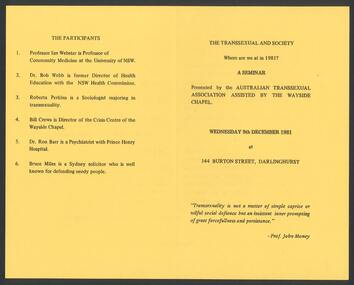
Ephemera, Australian Transsexual Association (ATA), The Transsexual and society : Where are we at in 1981? : a seminar, 1981
Additional text: "The participants: 1. Professor Ian Webster is Professor of Community Medicine at the University of NSW; 2. Dr Bob Webb is former Director of Health Education with the NSW Health Commission; 3. Roberta Perkins is a Sociologist majoring in transsexuality; 4. Bill Crews is Director of the Crisis Centre of the Wayside Chapel; 5. Dr. Ron Barr is a Psychiatrist with Prince Henry Hospital; 6. Bruce Miles is a Sydney solicitor who is well known for defending needy people."transexual, transgender -
Maldon Vintage Machinery Museum Inc
One Ton Truck
Used in annual Maldon Easter parade.Graham Brothers flat bed one ton truck. In-line four cylinder engine. Blue body with white engine housing, red engine block, cream wheel trim and upholstery maroon chasis. Natural timber seat frame, tray and running boards. Chrome radiator housing and headlights. Retrofitted electric turning indicators.Etched plate on dashboard "1 Ton CAUTION Truck / Over-loading or over-speeding / will void your warranty / Speed 25 miles per hour / Maximum allowable load capacity 2000 lbs / Allowable for weight of body 1000 lbs / Total weight of chassis body -------- / and load not to exceed 5515 lbs / deduct excess body weight from rated load / Graham Brothers Detroit. U. S. A. / A division of Dodge Brothers Inc." On cast wheel hub nuts "GB" -
 Victorian Harness Racing Heritage Collection at Lord's Raceway Bendigo
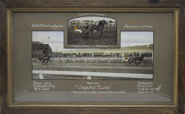
Photograph - Wooden framed photo finish, Akers & Co, Grand Echo, 4 March 1940
Grand Echo won the £500 Trotting Derby Trotters Division at Ascot on the 4 March 1940. Grand Echo Bred and Educated by Mr E Earl. One large and one small coloured photographs in a brown frame. Top line: £500 Trotting Derby / Trotters Division / Ascot 4/3/40 Second line under small photo: Grand Echo Returns Bottom line: Bred and Educated by Mr E Earl / Won by Grand Echo / Walladown 2nd / Lorna Redmond 3rd /Distance 1 mile / H'cap Scr / Time 2 m 30 1/2 / Rate 2m 30 1/2 Bottom right corner: Akers & Co Melbournehorses, race, winner, driver, trainer, owner, ascot, 1940, grand echo, mr e earl, walladown, lorna redmond -
 Victorian Harness Racing Heritage Collection at Lord's Raceway Bendigo
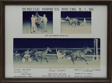
Photograph - Framed photo finish, Greg Matthews Photo, Bag Limit, 8 January 1986
Bag Limit won the Bendigo Pacing Cup on the 8 January 1986, followed by Quite Famous and Times Run Out. Bag Limit owned by ML Falls, AM Osborne, P & WM Day, was trained by RV Knight and driven by Vin Knight. Bag Limit raced from 1985 (3yo) through to 1990 (8yo). Career: 35 wins 16 seconds 5 thirds 71 starts.Three colour photographs, two small one large in a brown frame. At the top: Bendigo Harness Racing 8-1-86/ Coca Cola Bendigo Pacing Cup At the bottom: Left corner: Distance 2300 metres/ Mile rate 2.02.8/ Track Record / Greg Matthews Photos - Stawell Centre: Bag Limit (Tarport Skipper - Royal Blend) / Quite Famous 2nd / Times Run Out 3rd Right corner: Owned by- ML Falls, AM Osborne, P & WM Day/ Trained by RV Knight / Driven by Vin Knightbendigo harness racing club, horses, race, winner, bendigo trotting club, pacing cup, driver, trainer, owner, 1986, bag limit, rv knight, vin knight, ml falls, am osborne, p & wm day, quite famous, times run out, vj knight, bob knight -
 Victorian Harness Racing Heritage Collection at Lord's Raceway Bendigo
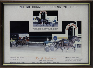
Photograph - Framed photo finish, Greg Matthews Photo, Knight Rainbow, 20 January 1995
Knight Rainbow won the Bendigo Pacing Cup on the 20 January 1995, followed by Magic Fella and Its Nero's Fiddle. Knight Rainbow owned by Mr C Price, was trained by NR Alexander and driven by Chris Alford. Knight Rainbow raced from 1992 (2yo) through to 1997 (7yo). Career: 22 wins 8 seconds 8 thirds 85 starts.Two colour photographs, one small one large in a brown, black, gold frame. At the top: Bendigo Harness Racing 20-1-95/ Jetport Security Parking Ten Victoria Bendigo Pacing Cup / C9 or Better At the bottom: Left corner: Distance 2700 metres/ Mile rate 2.01.2 / Greg Matthews Photos - Stawell Centre: Knight Rainbow (Tuapeka Knight - Tina Scott) / Magic Fella 2nd / Its Nero's Fiddle 3rd Right corner: Owned by- Mr C Price/ Trained by NR Alexander / Driven by Chris Alfordbendigo harness racing club, horses, race, winner, bendigo trotting club, pacing cup, driver, trainer, owner, 1995, knight rainbow, nr alexander, chris alford, mr c price, magic fella, its nero's fiddle, ca alford -
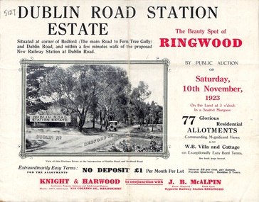 Ringwood and District Historical Society
Pamphlet, Land Sale Brochure, Dublin Road Station Estate - 1923
"Extracts from Recent Daily Newspaper - Ringwood Train Service - STATION WANTED AT RINGWOOD EAST. A deputation from the Ringwood East Railway League and Progress Association waited on the chairman of the Railway Commissioners yesterday afternoon and asked that a railway station be erected at Dublin-road, a mile and a quarter from Ringwood. The deputation urged that there were 81 passengers who, if the station were provided, would make daily use of it, and that as the Commissioners had purchased a site for a station at Dublin-road it was evident they had at one time considered it the most suitable site. The Chairman of Commissioners stated that the estimated cost of the station was £3700. Land owners in the locality should pay a proportion of the cost. Members of the deputation replied that there would be no difficulty in raising the money."Multi-fold brochure advertising public auction of residential allotments on Saturday, 10th November, 1923. Brochure includes subdivision features, local facilities and photographic images of the area and details of proposed new railway station at Dublin Road.Subdivision plan includes Dublin Road, Alexandra Road, Vonadawn Avenue, Green Street, Howard Avenue, Wood Street, and Bedford Road (Main Ferntree Gully Road). Auctioneer - Knight & Harwood, 315 Collins Street, Melbourne, Phones Central 10615, 10616. Agent - J.B. McAlpin, Opposite Railway Station, Ringwood, Phone Ringwood 7. -
 Eltham District Historical Society Inc
Map, George W. Bell, A Visitor's Guide Map; ELTHAM, WARRANDYTE and Environs. Shire of Eltham Centenary Souvenir, 1971
Commissioned by George W. Bell, designed by Anthony Harvey. An old gold mining and wine growing district eighteen miles from Melbourne, now notable for its arts, crafts, good food and historic buildings. On the reverse side printed in 8 panels (3 half-folds) advertising for Montsalvat, Eltham; Kutta Mahal Gallery, Warrandyte; Country Art Store, Eltham; Eltham Crafts. Monstsalvat, Eltham; Tantoon native plants and culinary herbs, Eltham; The Claypot, Warrandyte; Research Trading, Research; Potters Cottage, Warrandyte; Graeme Law & Associates Pty Ltd, Kew.. In addition is provided The Shire of Eltham Cenenary 1871-1971 , Centenary Celebrations Programme of events from March through to August 1971.44..8 x 57.5 cm (Four copies) On the reverse side (of one copy only) is printed in 8 panels (3 half-folds) advertising and Centenary Program.eltham, warrandyte, map, advertising, montsalvat, kutta mahal gallery, country art store, the claypot, research trading, potters cottage, graeme law & associates pty ltd, eltham crafts, tantoon, shire of eltham centenary, program -
 Federation University Historical Collection
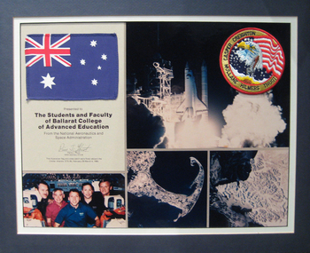
Assemblage, National Aeronautics & Space Administration (NASA) presentation to the Students of the Ballarat College of Advanced Education
The assemblage was presented to the students of Ballarat College of Advanced Education (BCAE) by a NASA astronaut. The Australian Flag and NASA Astronauts crew patch were flown aboard the Orbiter Atlantis, STS-36, 28 February to 4 March 1990. Astronaut Pierre Thout's first flight was as a mission specialist on the crew of STS-36 which launched from the Kennedy Space Center, Florida, on February 28, 1990, aboard the Space Shuttle Atlantis. This mission carried Department of Defense payloads and a number of secondary payloads. Following 72 orbits of the Earth in 106 hours, the STS-36 mission concluded with a lakebed landing at Edwards Air Force Base, California, on March 4, 1990, after travelling 1.87 million miles. bcae, nasa, space, pierre thuot, creighton, caspar, mullane, hilmers -
 Vision Australia
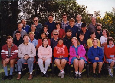
Photograph - Image, QBIC workers on the Annerley Campus of Yeronga TAFE
A group of QBIC workers and administrative staff. This image was used in the book "Vision Queensland, QBIC and Queensland Industrial Institution: a history 1883-1998" by Basil Shaw. Left to Right: Back row: Lionel Hubon, John Reed, Alan Nemeth, Lindsay Arndt, Kevin Watts, Tom Chawner. Third row: Sam McCord, Colin Ingram, Diane King, Jenny Scown, Andrew Brown, Lloyd Miles, Michael Thorn. Second row: Kenny Rogers, Yvonne Lord, Joe Seeto, Duncan Collard, Richard Howell, Greg Bond, Mark Pelgrave, May Brown. Front row: Tom Rowe, Michael Bor, Vicki Waugh, Anne Van Bekkum, Cathie Dendrik, Barbara Harding, Anne Maree O'Connell.1 x col. photograph of peopleProperty of Sam McCord - please return 20 Enlarge to 2 col wideemployment, qbic industries, lionel hubon, john reed, alan nemeth, lindsay arndt, kevin watts, tom chawner, sam mccord, colin ingram, diane king, jenny scown, andrew brown, lloyd miles, michael thorn, kenny rogers, yvonne lord, joe seeto, duncan collard, richard howell, greg bond, mark pelgrave, may brown, tom rowe, michael bor, vicki waugh, anne van bekkum, cathie dendrik, barbara harding, anne-marie o'connell -
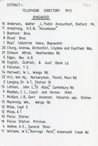 Ringwood and District Historical Society
Document, 1913 Ringwood Telephone Directory
One A4 sheetTELEPHONE DIRECTORY 1913 RINGWOOD 16 Anderson, Walter J, Public Accountant, Belford Pk. 17 Armstrong, H.E.B., 'Korumbeen'' 3 Bamford Bros. 8 Blood Bros. 1 Boys' Industrial Home, Bayswater. 20 Chung, Andrew, Orchardist, Lilydale and Eastfield Rds, 21 Dickson Alfred, Heatherdale Rd. 5 Edgar, Rev. A.R. 18 English. Scottish, & Aust. Bank Ld. 6 Falconer, T. S. 14 Harnwell, W.J., Wonga Rd. 22 Hill, Wm.Hy, Nurseryman, Florist, Main Rd. 2 Langley, Or A.T. Station St. 15 Lothian, John I, "St Abbs" Canterbury Rd. 9 Madden, C. L., Coach and Horses Hotel. 7 McAlpin, J. B., Govt. Assessor, Valuator, opp. Station. 13 Mackinlay, Wm., Wonga Rd. 12 Miles, Capt. E. 12 Miles, A.T. 10 Police Station. 19 Police Station. Mitcham. 4 Walker, A.E., General Store. 11 Williams, W.S., 'Berringa Park,' Andersons Creek Rd. -
 Orbost & District Historical Society
black and white photograph, first half 20th century
The lady in this photograph is probably Mrs Eveline Trevaskis who taught at the Wairewa School. Mrs. Trevaskis taught school from her early 20’s in different parts of Victoria. She gave it up to get married, has four children and 11 grand-children. Four of her grand-children are at Wairewa school. Mrs. Trevaskis went back to teaching during the wartime teacher shortage. She relieved at Buchan East State School for two years, getting up at 3.45 am to drive the 24 miles in pony and jinker. Wairewa State School, No. 3739 was built in 1923. The school closed at the end of 1973. Mrs Trevaskis was the teacher at Wairewa 1919-22 and 1945-1956. ( more information in News letter No. 123 NOVEMBER, 2015 - John Phillips)This item is associated with the history of education in East Gippsland.A black / white photograph in a small cream coloured folio. It is of an older lady seated on a chair with a young child on her lap. The child is laughing.inside cover - "Teacher at Wairewa"educatio-east-gippsland wairewa-state-school trevaskis-eveline -
 Orbost & District Historical Society
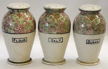
shakers, after WW11 (?)
These items were owned and used by Alice Pow (nee McWilliam), known as Maccie. Maccie was a nurse who came to Orbost in 1936. She was highly respected in Orbost for her nursing skills particularly during the 1938 outbreak of polio, Most patients were cared for in their homes and Miss McWilliam was sent out to care for them. Over 14 months she travelled 9560 miles supervising their treatments. She eventually married Mr Hec Pow who had been left to bring up his three daughters after his wife died.. The Pows lived in Orbost where Hec Pow was worked with his father Fred at the saw mill in Cabbage Tree. Maccie Pow was a member of the Orbost Bowling Club, Red Cross and Orbost Golf Club.Three vase shaped pottery shakers. Each has a cork stopper i n the base and sprinkle holes on the top. They are pale green coloured to half way and the rest is pale green with pink flowers. The surface is dimpled. On the base : ANDOVER Made in Japanchina tableware shakers pow-maccie mcwilliam-alice -
 Orbost & District Historical Society
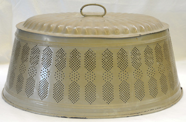
food cover, 1940's (?)
This item was owned and used by Alice Pow (nee McWilliam), known as Maccie. Maccie was a nurse who came to Orbost in 1936. She was highly respected in Orbost for her nursing skills particularly during the 1938 outbreak of polio, Most patients were cared for in their homes and Miss McWilliam was sent out to care for them. Over 14 months she travelled 9560 miles supervising their treatments. She eventually married Mr Hec Pow who had been left to bring up his three daughters after his wife died.. The Pows lived in Orbost where Hec Pow was worked with his father Fred at the saw mill in Cabbage Tree. Maccie Pow was a member of the Orbost Bowling Club, Red Cross and Orbost Golf Club.An oval shaped metal food cover made of pressed tin painted tan. It has a loop handle on the top. The sides slope outwards and it is seamed on both sides. The bottom edge is rolled. The sides have a perforated design for air flow.food food-protection kitchen-ware pow-maccie mcwilliam-alice -
 Warrnambool and District Historical Society Inc.
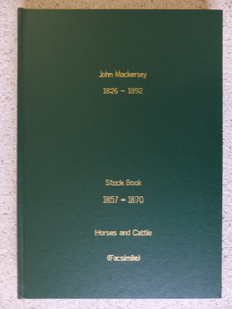
Book - Facsimile: John Mackersey 1826-1892, Stock Book 1857-1870, 2014
This ledger relates to the property Kenilworth which is situated near Cavendish, 16 miles from Hamilton on the Wannon River. It was taken up by Thomas Norris in 1839 and originally carried 800 cattle and 20000 sheep on 63000 acres. By 1858 it was in the hands of John Mackersey and Thomas Bostock. In 1859 it belonged outright to John Mackersey who was there until 1870. He was considered a worthy son of a Presbyterian minister and was well regarded in the district for his contributions in church, sport and sheep breeding... However he did not do well and lost the property before going to New Zealand in 1870. These journals provide a yearly record of flock, harvest and yields along with income details. It also provides details relating to rentals, selections and purchases during the era from squatting to freehold land. This journal provides a detailed view of matters relating to the business of sheep farming. It records purchases and stock sold, wool clips, lambs, sheep losses and different breeds. Kenilworth was a significant property in the Western District of Victoria and it dates from a period of early settlement in Victoria.Dark green hard cover with gold lettering. Both covers have in gold lettering: John Mackersey1826-1892 Stock Book 1857-1870. One cover has Horses and cattle and the other, sheep. It is a facsimile copy. The two sections are divided by a green sheet of paper. Acknowledgements to The State Government of Victoria, State Library of Victoria, Hamilton History Centre, Dr G Handbury AO, Margaret Gardiner, Godfrey and Margaret Mackersey, L Alan Brumley, M P Heuval. john mackersey, thomas bostock, thomas norris, kenilworth, history of warrnambool -
 Warrnambool and District Historical Society Inc.
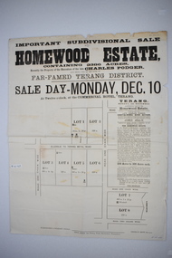
Original document, Advertising "Homewood Estate" Terang, 1886
This notice advertises the sale of the Homewood property near Glenormiston. The sale details state that the property is 2386 acres adjoining "The Sisters" the station of the Black Brothers. The property lies on the main metal road from Terang to Ellerslie, six miles from Terang. It has frontage to Pejark Marsh/drain. It was to be surveyed and sold in blocks of 250 to 300 acres with permanent water and well covered with grasses. The sale of the property followed the death of Charles Podger who died in 1886. On his death he left his wife Ann and six children.His worth was over 20000 pounds with 16000 pounds as real estate and 4300 pounds in personal propertyThe Agent for the sale was James Jellie, solicitors were Warrnambool firm Klingender and O'Mahony and the advertisement was printed by Thomas Smith Gas printing Works Warrnambool. This document has local interest and significance as an early sales of land in the district. The names of agents , solicitors and printers were wll known in the area and the property also a large holding. The Podger name is also well represented in the district to this day.Large white rectangular sheet of paper with black text . Major sale details in heavy black text at the top with descriptive text accompanying map of subdivision of the property on the left.The following names and details are contained within the document. Homewood Estate, Charles Podger, Commercial Hotel Terang, James Jellie Fenelon Mott Surveyor, Klingender & O'Mahony solicitors, Thos, Smith Gas Printing Koroit Street Warrnamboolcharles podger, homewood estate, klingender, o"mahony, kolora, the sisters, terang -
 Warrnambool and District Historical Society Inc.
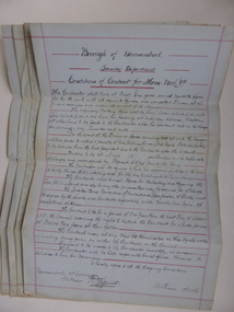
Document, Conditions of contract for Horse work Tramway Department, C1881
In 1858 a tramway was constructed to move goods between Warrnambool township and jetty on Lady Bay which was over a mile away The terminus was established on the southern side of Merri Street. and the track went around the edge of Lake Pertobe reserve. Large stores were also built near where the present railway station is situated to hold produce and carriages. According to these documents , the horses were required for many different tasks in the operation of the tramways including the moving of freight, removal of sand from the area, shunting of trucks and ballasting and repairing lines when necessary.The contractors had a list of conditions imposed including the provision of six horses of strong working ability and sufficient finances. The contract period was for 1 year and payment was monthly in arrears and hours of operation were from 7 am to 6 pm. These handwritten documents provide an insight into the type of work done in the early days of Warrnambool and the working conditions at the time. Five folded grey paper with red lines around edges. Written in black ink. Only front page of each piece has writing on it. 001262.1 Borough of Warrnambool Tramway Department Specification of Duties Contractor for Horse Work Signed William Bell 28/09/1881 001262.2 Borough of Warrnambool Tramway Department Conditions of contract for Horse Work. Signed Daniel Gallagher 20/09/1881 001262.3 Borough of Warrnambool Tramway Department Specification of Duties Contractor for Horse Work Signed Daniel Gallagher 20/09/1881. 001262.4 Borough of Warrnambool Tramway Department Specification of Duties Contractor for Horse Work Signed Michl Daly 5th September 1878 crossed out 001262.5 Borough of Warrnambool Tramway Department Conditions of contract for Horse Work Signed William Bell 28/09/1881warrnambool, warrnambool tramway, horse work, tramway contract -
 St Kilda Historical Society
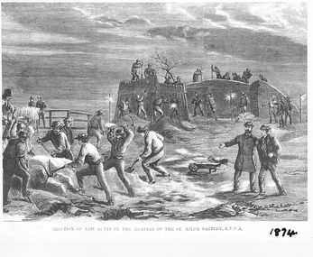
Photograph - Photograph of artwork, Illustrated Sydney News, Erection of New Butts by the Members of the St Kilda Battery R.V.V.A, 28/02/1874
Erection of new butts by the members of the St Kilda Volunteer Army Corps in 1874, after the government took possession of the land that the Volunteer Army Corps had been using. The butts were banks constructed of sand and earth, kept together with saplings, to create areas for shooting practice. They were constructed on the beach at Hobson's Bay, half a mile from the St Kilda jetty. An article about this appeared in the Illustrated Australian News for Home Readers on 25 February 1874, available on the National Library of Australia Trove site https://trove.nla.gov.au/newspaper/article/63105925. The lithograph appeared in the Illustrated Sydney News and New South Wales Agriculturalist and Grazier on 28 February 1874, available on the National Library of Australia Trove site https://trove.nla.gov.au/newspaper/article/63105925Photograph of black and white lithograph Erection of New Butts by the Members of the St Kilda Battery R.V.V.A. 1874st kilda volunteer army corps -
 Dandenong/Cranbourne RSL Sub Branch
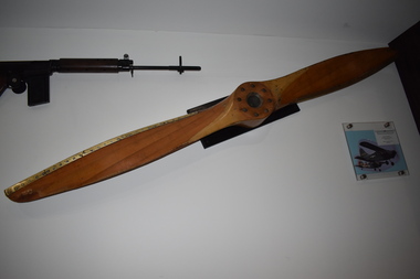
Memorabilia, Aircraft propeller
The Stinson L - 5 Sentinel was a World War 11- era liaison aircraft used by the United States Army Air Forces, U.S Army Ground Forces, U>S Marine Corps and the British Royal Air Force. It was produced by the Stinson Division of the Vultee Aircraft Company (Consolidated - Vultee from mid- 1943). Capable of operating from short unimproved airstrips the L - 5 Sentinel delivered personnel, intelligence, and supplies to the front line. On return flights it carried wounded soldiers who were evacuated to rear area field hospitals for treatment. The L - 5 carried a pilot and observer. It had a length of 24.1 feet, wingspan of 34 feet, It had a maximum speed of 130 mph, a cruise speed of 100 mph with a range of 375 miles.The L - 5 was a significant asset to the allied war effort.Wooden propeller from Lycoming engine, with photograph of aircraft. Stinson L 5 Sentinal reconnaissance plane used in Korea and Vietnam. Propeller displayed from a similar plane. -
 Ballarat Heritage Services
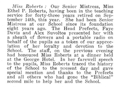
Newspaper - Newspaper article, Miss Roberts, Ballarat East High School
Miss Roberts: Our Senior Mistress, Miss Ethel P. Roberts, having been in the teaching service for forty-three years retired on September 14th this year. She had been senior mistress at our School since its foundation eight years ago. The Head Prefects, Faye Davis and Alex Suvoltos presented her with a sheath of flowers and a portable radio on behalf of the pupils as a token of our appreciation of her loyalty and devotion to the School. The staff, on the previous eveing had honoured Miss Roberts at a dinner held at the George Hotel. In her farewell speech to the pupils, Miss Roberts traced the history of the School to the present day and gave special mention and thanks to the Prefects and all others who had gone the "Biblical" second mile to help her and the School.miss roberts, ballarat east high school, ethel roberts, faye davis, alex suvoltos -
 Surrey Hills Historical Society Collection
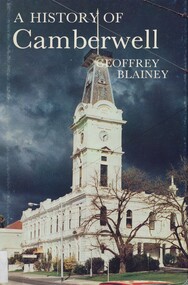
Book, A history of Camberwell, 1980
In 1964 Camberwell City Council commissioned Professor Geoffrey Blainey to first write this history. Since that time, many changes have taken place and therefore the Council asked Professor Blainey to bring the book up to date. Bibliography, includes index. The author presents a century of pioneering development and endeavours. He has traced the coming of the wood-cutters and the farmers, the transition from rectangular paddocks to a grid of roads and streets, the growth from shire to borough, town and city, the filling up of thirteen squares miles into residential suburbia - in successive waves of invasion, along new transport routes - including the Outer Circle Railway. Substantial chapters cover the War Years and the progress of Camberwell since the 1960s have also been included in this edition. 134p; ill;camberwell, victoria, market gardens, tolls, railways, mayors, boroondara road board, borondara shire, councillors, (mr) (prof) geoffrey blainey -
 Federation University Art Collection
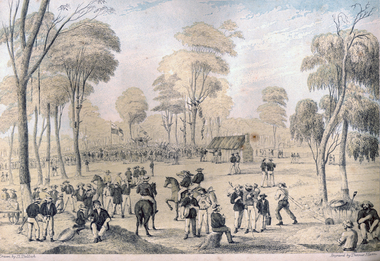
Print - Printmaking - Lithograph, Tulloch, David, 'Great Meeting of Gold Diggers Dec 15th 1851' by Thomas Ham, 1852
One of the first large goldfield meetings was at Castlemaine in 1851. After the extraordinary success of the Mt Alexander Diggings the Government issued a proclamation, raising the licence fee from thirty shillings to three pounds. As soon as these intentions became known a public meeting of miners was held. For miles around work ceased, with diggers travelling as far as Bendigo to attend the meeting. It is estimated that around 18,000 people attended the meeting. The notes with the engraving state The trees in this locality are chiefly Stringybark; some of them are peeled of their covering, as many persons prefer erecting bark huts to living in a comfortless tent. The various groups, and costumes of the men, are characteristic of our gold digging community. This item is part of the Federation University Art Collection. The Art Collection features over 2000 works and was listed as a 'Ballarat Treasure' in 2007.Colour lithograph of a meeting of diggers at a meeting in Mt Alexander. The meeting was the result of goldfields agitations against the license fee. lower centre "Great Meeting of Gold Diggers Dec 15th 1851" lower left side "Drawn By D. Tulloch" lower right side "Engraved by Thomas Ham"art, artwork, ham, thomas ham, tulloch, castlemaine, goldfields agitation, printmaking, edition, coloured lithograph, david tulloch, gold pan, shovel, wheelbarrow, waggon, bark hut, ring barked tree, gold mining -
 Federation University Historical Collection
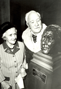
Photograph - Photograph - Black and White, Ballarat Courier, Dick Richards and his sister, Mrs V.S. Greenhalgh with the Bust of Dick Richards, 06/1983
Dick Richards joined the Ballarat School of Mines in 1914, and soon afterwards was granted leave to join an expedition to Antartica. In 1915 he sailed from Australia with the Antartic Exploraton Expedition, led by Sir Ernest Shackleton. Most Antarctic enthusiasts know of Ernest Shackleton's attempt to cross the continent, only to be thwarted by the sinking of the ship 'Endurance'. Dick Richards was the physicist and sled manager for Shackleton's Ross Sea Party - with the task to meet Shackleton on the other side of the continent. When Shackleton planned his transcontinental crossing he decided to use supply depots as loads of supplies were too heavy to pull. The depots would enable Shackleton's party to carry just enough to reach the Pole, relying on the depots which were to be left by the Aurora's crew every 60 miles, stowed in 2 sledge journeys in 1915 and 1916. Dick Richards spent 3 freezing years in Antarctica between 1914 and 1917. Richards' worst experience was when his ship Aurora, tethered offshore, was blown away in a gale leaving Richards marooned for two years with nine other men on the ice floe. The expedition, consisting of two teams, were attempting to cross Antarctica from opposite sides, linking up somewhere near the middle. "That was with pretty poor equipment by today's standards, and we did not make it." (Dick Richards) The Ross Sea Party arrived in McMurdo Sound aboard the Aurora in January 1915. The men planned to make two sledging trips to leave supply depots every 60 nautical miles to Mount Hope about 400 miles away. The going was tough as the sledges were overloaded. Temperatures were as low as minus 68F. In June 1916 the party crossed on foot to Cape Evans, occupied Scott's Hut (from his Terra Nova Expedition, erected in January 1911) in May 1915, for two months. On 10 January 1917 Richards was hunting for seals when he saw a ship on the horizon. It was 'The Aurora'. Picking up the relieved survivors 'The Aurora' arrived in New Zealand on 9 February 1917 to a hero's welcome. Joyce, Wild, Hayward and Richards later won the Albert Medal for their heroic devotion to duty. Later an inlet on the Antartic continent was named after Richards. Dick Richards wrote the following years after the ordeal "To me no undertaking carried through to conclusion is for nothing. And so I don't think of our struggle as futile. It was something the human spirit accomplished." Prime Minister Bob Hawke wrote in 1984 'Your incredible journey of almost 2000 miles across the Antarctic Wastelands - involving some 9 months in the field with makeshift equipment - and you're adherence to duty in the face of enormous difficulty, suffering from scurvy, and the death of comrades, will; be an inspiration to your countrymen of the future as it is to us today." After returning to Australia Dick Richards resumed his work at SMB as Lecturer in Physics and Mathematics, and developed many pieces of experimental equipment. During World War Two he acted as a scientific adviser in the production of optical apparatus in Australia. In 1946 he was appointed Principal and twelve years later he retired after a total of 44 years service. Dick Richards has been honoured through the naming of a Ballarat School of Mines prize - The R.W. Richards Medal. This medal later became a University of Ballarat prize. It has been awarded annually since 1959 to the Bachelor of Applied Science graduate considered to have achieved the most outstanding academic performance of their course. (See http://guerin.ballarat.edu.au/aasp/is/library/collections/art_history/honour-roll/honourroll_Richards,Dick.shtml )A man and lady inspect a bust of Richard (Dick) Richards by sculptor Victor Greenhalgh. The scultpure is at the Ballarat School of Mines. The man is Dick Richards, and the woman is his sister and wife of sculptor Victor Greenhalgh. Both Dick Richards and Victor Greenhalgh were former students and teachers at the Ballarat School of Mines. The bust of Dick Richards was Victor Greenhalgh's last work and was cast in bronze after his death. The bust was presented to the Ballarat School of Mines by Mrs V.S. Greenhalgh (widow of the sculptor and sister of the subject). At the presentation Victor Greenhagh's son said "the two men had been friends as well as brothers-in-law, were of similar age, both enjoyed red wine, beer and cricket and both were educationalists, one an artist the other a mathematician."dick richards, r.w. richards, richards, richard w. richards, victor greenhalgh, bust, sculpture, ballarat school of mines, antarctica, ross shore -
 Ballarat Tramway Museum
Document - Report, Graeme Cleak, "Trams, Deficits move out as private buses move in", 2006
Sixteen page printed report, stapled in top left hand corner, titled "Trams, Deficits move out as private buses move in", extracted from Truck and Bus Transportation March and April 1957, about the replacement of the trams in Geelong. Written by a bus person. Part 1 - Looks at the changeover from trams to buses, background to the tram service in Geelong, political issues, publicity, bus companies and areas operate, peak hour services, buses used, standards, traffic levels, miles operated, drivers viewpoints. Part II - looks at the savings by bus operations, no fare subsidies at the time, gives a table of losses on Ballarat, Bendigo and Geelong from 1931, track replacement costs, details of the three companies operating buses, Trans Otway, Benders and Corio Bus Lines and other operators in the Geelong region. Obtained by Graeme Cleak from the Internet and copy given to Gavin Young Scanned entire document and added 2/9/12. trams, tramways, geelong, buses, reports, tram bus services, closure -
 Kew Historical Society Inc
Plan, Studley Park Estate, 1910
Prue Sanderson, in her groundbreaking ‘City of Kew Urban Conservation Study : Volume 2 - Development History’ (1988), summarised the periods of urban development and subdivisions of land in Kew. The periods that she identified included 1845-1880, 1880-1893, 1893-1921, 1921-1933, 1933-1943, and Post-War Development. These periods were selected as they represented periods of rapid growth or decline in urban development. An obvious starting point for Sanderson’s groupings involved population growth and the associated economic cycles. These cycles also highlighted urban expansion onto land that was predominantly rural, although in other cases it represented the decline and breakup of large estates. A number of the plans in the Kew Historical Society’s collection can also be found in other collections, such as those of the State Library of Victoria and the Boroondara Library Service. A number are however unique to the collection.The Kew Historical Society collection includes almost 100 subdivision plans pertaining to suburbs of the City of Melbourne. Most of these are of Kew, Kew East or Studley Park, although a smaller number are plans of Camberwell, Deepdene, Balwyn and Hawthorn. It is believed that the majority of the plans were gifted to the Society by persons connected with the real estate firm - J. R. Mathers and McMillan, 136 Cotham Road, Kew. The Plans in the collection are rarely in pristine form, being working plans on which the agent would write notes and record lots sold and the prices of these. The subdivision plans are historically significant examples of the growth of urban Melbourne from the beginning of the 20th Century up until the 1980s. A number of the plans are double-sided and often include a photograph on the reverse. A number of the latter are by noted photographers such as J.E. Barnes.Coloured lithograph of a subdivision plan of the Studley Park Estate, bordered by Yarra, Willsmere Road and the Outer Circle Railway line. The estate was listed in 1910 and was the subject of a planning dispute between the developer and the Town of Kew in relation to flood levels and the suitability of the land for housing. In many cases the names of streets were subsequently changed. The layout was also affected by the creation of the Eastern Freeway. A newspaper report of the day described the subdivision as a: "GOLDEN OPPORTUNITY. We are pleased to submit for PRIVATE SALE that magnificent ESTATE, situated only 4 1/2 miles from the Melbourne General Post Office, STUDLEY PARK ESTATE. KF/NV. Doubtless the CHEAPEST LAND EVER OFFERED having extensive frontages to the prettiest spot on the River Yarra and the National Park, commanding lovely river and landscape views, and acknowledged to be the finest land available so close to the city. The PRICES ARE EXTREMELY MODERATE; The TERMS ARE SIMPLY MARVELLOUS. NO DEPOSIT. NO DEPOSIT. NO DEPOSIT. Allotments and prices to suit everyone."subdivision plans - kew, studley park estate -
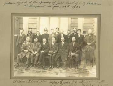 Ringwood and District Historical Society
Photograph, Opening of first court of Petty Sessions - Jusices and Occiails Group Photograph, Ringwood 1933
Multiple copies of group photo, in mounting boards, with signatures. Hand written above one copy of photograph, "Justices and Officals at the Opening of first court of Petty Sessions at Ringwood on JUne 29th 1933". Various signatures on two copies including , "Arthur Blood, JP, Robert Dawes, JP, A. Temple Miles, JP, W. C........., J.G. Aird, JP, MacGaskill, JP, A. ..B. Long, JP." Written on back of photograph, "Cr. J. K. McGaskill JP With complements from the Mayor of Ringwood Cr. R.W. Dawes JP, J.G. Aird, JP. -
 Ringwood and District Historical Society
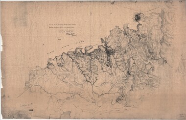
Map, Survey of Dividing Range between Yarra Yarra and Western Port - William Wedge Darke, 1843
Extract - Ringwood, Place of Many Eagles - Hugh Anderson (1974): William Wedge Darke, from Hereford, England, was a nephew of John Helder Wedge of the Port Phillip Association, who was also a surveyor. William's most important work was probably his survey of the Dividing Range and the country between the Yarra River and Western Port, completed in May 1843, and during which he made a traverse between the Mullum and Dandenong creeks along the higher ground that he labelled the "best line of road from Melbourne". This road was for many years the major route to Gippsland and to the higher country about Alexandra and Mansfield, sometimes known as White Horse Road, and now Maroondah Highway.Surveyor's relief map of features to the east of Melbourne including Yarra Yarra River, Mullum Mullum Creek, Anderson's Creek, Dandenong Creek.Transmitted to the Surveyor General with my letter of 10th May 1843 (signed) Wm Wedge Drake, Assistant Surveyor. Scale: two inches to a mile. Descriptive remarks include upstream area of Yarra River - "impassable, appears to have been formerly a lake", and to the south - "barren and scrubby swamps of the Western Port Country". Marked tracks include "best line of road from Melbourne", "track to Dandenong", "Road to Port Albert may probably be found on this range", "Best line to Upper Yarra". Several huts also marked. -
 8th/13th Victorian Mounted Rifles Regimental Collection
Photograph - watering horses
See also 3089.86. Information with that photo gives an alternative provenance: 8th Light Horse Regiment watering horses at a Murray River lagoon, South Corowa NSW, September 1939; Wahgunyah Troop, C Squadron - this side of lagoon, Lieutenant J. Nott on grey horse in water. The number of horsemen would seem to exceed that of a single regiment so the Torquay description would seem more probable.Black and white photograph ( laminated ) of 8th, 13th,20th, and 4thLight Horse Regiments watering horses near Torquay Victoria , March 1940.Picture taken about March 1940 when the 13th Light Horse from Gippsland, the 8th Light Horse from Upper Murray, the 4th Light Horse from the Western Districts and the 20th Light Horse from the Goulburn Valley were in camp near Torquay. Mr Cappur Webb of Glendoxey, Seymour, a member of the 20th said the picture must have been taken during and exercise about five miles north of Torquay. “We used to water our horses in that lake”, he said." light horse, torquay, wwii, world war two, military, horses -
 Diamond Valley Vietnam Veterans Sub-Branch
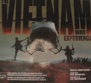
Book - n/a, The Vietnam War Experiance, 26/3/2010
A comprehensive containing many rare and removable facsimile documents of historical importance, Includes rare photographs, images and insignia from the collection of the Australian War Memorial.One book of many in relation to the Vietnam War.Hardback book in box; Authors: Gerry and Janet SouterThe Five Mile Press Pty Ltd/950 Stud Road, Rowvville Victoria 3078 Australia/Email: [email protected]/Website: www.fivemile.com.au/This book is sold subject to the condition that it shall not, by way of trade or otherwise, be lent, resold, hired out or otherwise circulated without the publisher's prior written consent in any form of cover or binding other than that in which it is published and without a similar condition including this condition, being imposed on the subsequent purchaser./Printed in China 5 4 3 2 1 vietnam, vietnam war, diamond valley vietnam veterans sub branch, books -
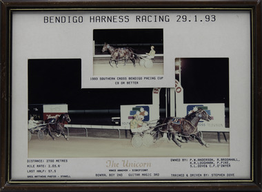 Victorian Harness Racing Heritage Collection at Lord's Raceway Bendigo
Photograph - Framed photo finish, Greg Matthews Photo, The Unicorn, 29 January 1993
The Unicorn won the Bendigo Pacing Cup on the 29 January 1993, followed by Bowral Boy and Guitar Magic. The Unicorn owned by PW Anderson, R Broomhall, KR Loughnan, P Pike, SL Dove & CF O'Dwyer, was trained and driven by Stephen Dove. The Unicorn raced from 1989 (2yo) through to 1995 (8yo). Career: 29 wins 18 seconds 14 thirds 94 starts.Two colour photographs, one small one large in a brown, black, gold frame. At the top: Bendigo Harness Racing 29-1-93/ 1993 Southern Cross Bendigo Pacing Cup / C9 or Better At the bottom: Left corner: Distance 2700 metres/ Mile rate 2.03.6/ Last Half 57.5 / Greg Matthews Photos - Stawell Centre: The Unicorn (Vance Hanover - Significant) / Bowral Boy 2nd / Guitar Magic 3rd Right corner: Owned by- PW Anderson, R Broomhall, KR Loughnan, P Pike, SL Dove & CF O'Dwyer/ Trained and driven by Stephen Dovebendigo harness racing club, horses, race, winner, bendigo trotting club, pacing cup, driver, trainer, owner, 1993, the unicorn, stephen dove, pw anderson, r broomhall, kr loughnan, p pike, sl dove, cf o'dwyer, bowral boy, guitar magic, s dove, carl o'dwyer