Showing 3069 items matching "scales"
-
 Stawell Historical Society Inc
Coin - Realia, R. PARKER IRONMONGER GEELONG MOORABOOL STREET
HEATON & SONS, BIRMINGHAM WERE EMPLOYED TO STRIKE THE EXTENSIVE TOKEN ISSUES. THE IRONMONGERY STORE IN MOORABOOL STREET, GEELONG WAS ESTABLISHED IN 1844 BY RICHARD PARKER. PARKER WENT ON TO ESTABLISH STORE IN CLUNES, BACK CREEK (TALBOT), FIREY CREEK AND ARARAT. HE ISSUED AT LEAST TEN VARIETIES OF TOKENS, ALL WITH THE SAME INSCRIPTION AND FIGURE ON THE FACES, BUT WITH SLIGHT VARIATIONSCOPPER PENNY TOKEN 34MM OR 35 MM DIAMETER OBVERSE: INSCRIBED WITH R PARKER IRONMONGER MOORABOOL STREET GEELONG REVERSE: HAS A FEMALE FIGURE REPRESENTING JUSTICE, HOLDING A BALANCED SET OF SCALES IN HER RIGHT HAND. THE WORD AUSTRALIA IS AROUND THE TOP OF THE TOKEN. ,token coin -
Southern Sherbrooke Historical Society Inc.
Map, Dept of land s & Survey, Dandenong Ranges Area Sheet 28, Jan-56
Owned by David Walker, previously of Menzies Creek. Given by him to Rex Breen in 2001 for donation to society.Aerial survey map of parts of Gembrook, Monbulk and Naree Worran parishes (Victoria). Scale: 10 chains to 1 inch, contour interval 20 feet. Shows Menzies Creek and parts of Kallista, Clematis, Selby and Belgrave South. Ringwood D2C or 849D2C, Zone 7"16563" in pen on top left corner of reverse. -
![Hand-Drawn Map Centred on Myrtleford by Frank Lebbell Frost [ca 1915-1918]](/media/collectors/51d110e42162ef12e06aa06b/items/51fb0bb72162ef156c79aeee/item-media/52a11c442162ef1f0c9c052b/item-fit-380x285.jpg) Beechworth Honey Archive
Beechworth Honey ArchiveHand-Drawn Map Centred on Myrtleford by Frank Lebbell Frost [ca 1915-1918]
This is one of the maps drawn by Frank L. Frost while he was beekeeping in North-East Victoria. This particular map may be reference in the "Wooden" Diary on page 8.Hand-drawn map centred on Myrtleford, Palmerston, Gapstead Road, the Ovens River and the Myrtleford-Wangaratta Road. Shows locations of flowering eucalypts. Scale is 1 mile to 1 inch. Drawn with black pen and grey lead on paper. Names of towns are marked in red pen. hand drawn, hand-drawn, map, myrtleford, palmerston, gapstead, ovens, beekeeping, frost, beechworth honey -
![Map, Plan of Subdivision of Crown Portion 23 & parts 24-25, Parish of Korkuperrimul [1900s?]](/media/collectors/5e461d8021ea67224c82f2a1/items/675fe058304668462205d4fb/item-media/675fe0ef304668462205d7d6/item-fit-380x285.jpg) Bacchus Marsh & District Historical Society
Bacchus Marsh & District Historical SocietyMap, Plan of Subdivision of Crown Portion 23 & parts 24-25, Parish of Korkuperrimul [1900s?]
The Parish of Korkuperrimul includes a significant section of the township of Bacchus Marsh and extends in western and northern directions from the township area. The date of the subdivision indicated on this plan has not been established. The engineer's stamp on the drawing shows the firm of Muntz and Muntz who were operating under that name in the early part of the 20th century.A single page paper map showing 20 blocks of land for sale in the Parish of Korkuperrimul. Scale 100 feet to 1 inch. The map is pasted into a bound volume containing 76 maps or plans in total. High resolution digital image stored on BMDHS computer network. Stamped: 'Muntz & Muntz Civil Engineers, Architects & Surveyors, Trustees Chambers ?? Cor Collins Street and Bank Placeland sales bacchus marsh, bacchus marsh victoria maps, land sales korkuperrimul parish -
 Bendigo Military Museum
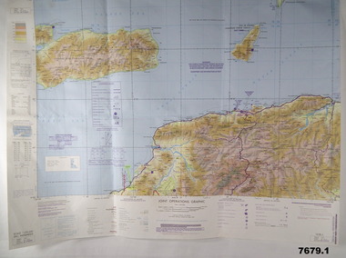
Map - MAPS, EAST TIMOR, US Govt et al, 1975 - 1976
1. This is a coloured map. It's scale is 1.250,000 - called a jpoint operations graphic. It covers the North side of East Timor. Dili is in the centre. Its shows 4 Islands to the north of Timor. It shows Savu Fea, Ombai Strait, Wetar Strait. On bottom left of map it shows Batheade and the start of the New Border. Map - Series 159. Sheet 5C- 51-4. Edition 3-GSGS. 2. This is a coloured map. Its scale is 1.250,000 called a joint Operations Graphic. It manly covers West Timor. It shows Savu Sea in North and Timor Sea on south side. Series 1501. Sheet SC 51.7. Edition 3-GSGS. 3. This a coloured map. It's scale is 1.250,000. Joint operations graphic. This map shows the south side of East Timor and the Timor Sea. This map shows a highlighted New border. The major towns on South coast are KAMFNASA, BETANO. Map series 1501. Sheet SC 51-8. Edition 3 GSGS.1. Has highlighted "7 BSG" on coast. All maps show East Timor border highlighted in pink.east timor, maps, interfet -
 Royal Australian and New Zealand College of Obstetricians & Gynaecologists (RANZCOG)
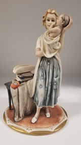
Sculpture - Bellini porcelain figure of a woman holding a baby
Porcelain figurine of a woman holding a baby. The woman is wearing a blue dress, with a blue floral pattern, underneath a white medical coat. She has blonde hair which is tied loosely behind her, and white slip on shoes. She is holding the baby in front of her chest, with the baby's back leaning against her left forearm and the baby's head cradled in her left hand. Her right hand is supporting the baby from beneath. The baby is loosely wrapped in a white blanket, with its torso visible. The woman is standing next to a small table which supports a set of baby weighing scales and a bottle of talc next to the scales. A cloth trails down from the table to the floor. There is a manufacturing mark on the back of the base of the statue. The top row of text is obscured, but the remaining test on the mark reads 'porcellane/PRINCIPE/MADE IN ITALY'. A small Certificate of Origin tag is attached to the weighing scales by a small, thin cord. Sticker underneath the base of the statue reads 'BELLINI/PONTE VECCHIO/FIRENZE'. -
 Greensborough Historical Society
Map, Australia. Department of Minerals and Energy, Melbourne, topographic map, 1970_
A topographic map of Victoria with Melbourne as the centre. Provisional edition showing contours in feet. International map of the world [scale] 1:1,000,000. Prepared by the Department of Minerals and Energy, Canberra in 1970.A pre-metric map, shows the Hume Highway travelling through towns such as Seymour and Benalla, now by-passed by the Hume Freeway.Map, printed in colour on one side.victoria - maps -
 Emerald Museum & Nobelius Heritage Park
Administrative record - Nobelius Nursery Day Book 14 May 1913 - 24 May 1916, 14 May 1913 - 24 May 1916
The Cash Accounts contain the names and transaction details of all Gembrook Nursery clients and gives an insight into the scale of the Nursery operations. At its peak, this Nursery was said to be the biggest in the Southern Hemisphere.This daybook May 1913-May 1916 was used to record Gembrook Nursery stock sales to clients in Victoria, Australia and overseas and contains the names and places of hundreds of clients thus giving an insight into the scale of the nursery operations at the time.Nobelius Nursery Day Book - 802 pages. Hard cover bound in black leather with sides in tan suede. On spine with gold embossed script: 'JOURNAL' Inside front cover, bookmaker's sticker: 'D. W. PATERSON CO.' Inside front cover, handwritten: 'No stock, Date 16/10/1012'c. a. nobelius & sons, gembrook nurseries, horticulture, accounting, emerald -
 Federation University Historical Collection
Booklet - Booklet - Prospectus, Bairnsdale District School of Mines, Prospectus, 1904, 1904
Higher education in east Gippsland dates back to 1890, and the opening of the Bairnsdale District School of Mines, In 1986 the Bairnsdale School of Mines and the Sale and Bairnsdale Technical schools amalgamated to form the East Gippsland Community College of TAFE. In 1995 it became the East Gippsland Institute of Technology, and in 2011 changed its name to Advance TAFE. The Bairnsdale District School of Mines Prospectus includes the members of council, a photographic image of the school, teaching staff, rules relating to students and instructors, Constitution, and a prospectus of subjects including Mining and Science Subjects, Diploma Courses, Preliminary Training, Metallurgy Course, Mining Engineering Course, Battery Manager's Certificate, Assayer's Certificate. It also includes a scale of fees, information on the Metallurgical Plant, Chemistry, Assaying and Metallurgy, Geology, Mining Geology, Mining, Petrology, Dynamics and Heat, Magnetism & Electricity, Mechanics Applied to Mining, Land Surveying, Mine Surveying, Algebra, Euclid, Trigonometry, Mechanical Drawing, Practical Plane Geometry, Practical Solid Geometry, Engineering Drawing, Art Subjects, and a list of certificates issued by the school since 1892.Grey soft covered book of 68 pages. The Bairsndale District School of Mines Prospectus includes the members of council, an photographic image of the school, teaching staff, rules relating to students and instructors, Constitution, and a prospectus of subjects including Mining and Science Subjects, Diploma Courses, Preliminary Training, Metallurgy Course, Mining Engineering Course, Battery Manager's Certificate, Assayer's Certificate. It also includes a scale of fees, information on the Metallurgical Plant and its chares, Chemistry, Assaying and Metallurgy, Geology, Mining Geology, Mining, Petrology, Dynamics and Heat, Magnetism & Electricity, Mechanics Applied to Mining, Land Surveying, Mine Surveying, Algebra, Euclid, Trigonometry, Mechanical Drawing, Practical Plane Geometry, Practical Solid Geometry, Engineering Drawing, Art Subjects, and a list of certificates issued by the school since 1892.bairnsdale district school of mines, bairnsdale, school of mines, donald clark, francis w. sewell, j.v.r. anderson, a.d. pleydell, walter seehusen, director, mining engineering, metallurgy, academy of arts, municipal surveyor, 1914 -
Moorabbin Air Museum
Manual (Item) - Jindivik Mk 203B General And Technical Information Book 2
Description: B&W Photos of a scale model and original aircraft. 2 of each 6 x 8 and 10 x 8 Orignal labelled 'Grafton' Date: 1988 Level of Importance: . -
 Whitehorse Historical Society Inc.
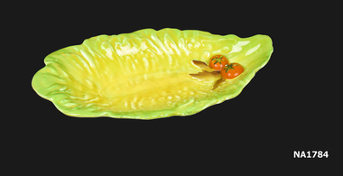
Domestic object - Dish, Calton Ware, 1936
Given to Daisy May Scales and Arthur Bate for their wedding on 29 - 2 - 1936 by their workmates at the Australian Tesselated Tile Co. in Mitcham. Daisy May Bate died 11 - 7 - 1993'Carlton Ware' Dish in the shape of a leaf - green edges with yellow centre and two tomatoes at point.Carltonware Made in England Trade Markdomestic items, crockery -
 Ballan Shire Historical Society
Map - Map. Bungal, Department of Lands and Survey, Bungal, County of Grant, 09/09/1926
A map of Bungal in the 1920's showing the allotments, and the size, with the names of the residents. It shows the roads and the Western and Eastern Moorarbool River, and the Whipstick State Forest.Cream coloured map of Bungal in the County of Grant, bounded by the the East Moorarbool River on the East, and the State Forest on the South. It is marked with the scale of chains and the number L.358. Lithographed at the Department of Lands and Survey. Melbourne by W. J. Butson on 9.9.1926. It shows the land allotments with names of owners.Coloured pen marks and circled numbers on various areas. Price 2 shillings marked on bottom right hand edge.bungal, kerrit bareet, egerton, lal lal, borhoneyghurk, bungeeltap, ballark, yaloak, gorong, moorarbool west -
 Flagstaff Hill Maritime Museum and Village
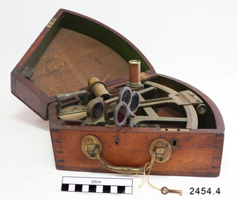
Octant, Mid to late 19th Century
An octant is an astronomical instrument used in measuring the angles of heavenly bodies such as the sun, moon and stars at sea in relation to the horizon. This measurement could then be used to calculate the altitude of the body measured, and then the latitude at sea could also be calculated. The angle of the arms of an octant is 45 degrees, or 1/8 of a circle, which gives the instrument its name. Two men independently developed the octant around 1730: John Hadley (1682–1744), an English mathematician, and Thomas Godfrey (1704–1749), a glazier in Philadelphia. While both have a legitimate and equal claim to the invention, Hadley generally gets the greater share of the credit. This reflects the central role that London and the Royal Society played in the history of scientific instruments in the eighteenth and nineteenth century's. There were also two others who are attributed to having created octanes during this period, Caleb Smith, an English insurance broker with a strong interest in astronomy (in 1734), and Jean-Paul Fouchy, a mathematics professor and astronomer in France (in 1732) In 1767 the first edition of the Nautical Almanac tabulated lunar distances, enabling navigators to find the current time from the angle between the sun and the moon. This angle is sometimes larger than 90°, and thus not possible to measure with an octant. For that reason, Admiral John Campbell, who conducted shipboard experiments with the lunar distance method, suggested a larger instrument and the sextant was developed. From that time onward, the sextant was the instrument that experienced significant development and improvements and was the instrument of choice for naval navigators. The octant continued to be produced well into the 19th century, though it was generally a less accurate and less expensive instrument. The lower price of the octant, including versions without a telescope, made it a practical instrument for ships in the merchant and fishing fleets. One common practice among navigators up to the late nineteenth century was to use both a sextant and an octant. The sextant was used with great care and only for lunar sightings while the octant was used for routine meridional altitude measurements of the sun every day. This protected the very accurate and pricier sextant while using the more affordable octant for general use where it performs well. The invention of the octant was a significant step in providing accuracy of a sailors latitude position at sea and his vessels distance from land when taking sightings of land-based landmarks.Octant with metal handle, three different colored shades are attached, in wooden wedge-shaped box lined with green felt. Key is attached. Two telescope eyepieces are in box. Some parts are missing. Oval ink stamp inside lid of box, scale is graduated to 45 degrees. Ink stamp inside lid of box "SHIPLOVERS SOCIETY OF VICTORIA. LIBRARY"instrument, flagstaff hill, warrnambool, shipwrecked coast, flagstaff hill maritime museum, maritime museum, shipwreck coast, flagstaff hill maritime village, great ocean road, octant, navigation, nautical instrument, navigation instrument, john hadley, sextant, astronomical instrument -
 Federation University Historical Collection
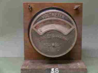
Scientific Instument, Stanley D'Arsonval, Voltmeter
D.C. Voltmeter 180-270 volt range. Black cylindrical shape, with partly chrome plated front cover and simi-circular glass window. Pointer indicator, semi-circular scale. This panel mount instrument is attached to a crudely varnished wooded stand for bench-top use. Serial Number 2172Vscientific instrument, ballarat school of mines, voltmeter -
Bendigo Historical Society Inc.
Map - CAMPBELL COLLECTION: BENDIGO AND DISTRICT MAPS, 18-6 29
Map. Longlea, Parishes of Axedale and Eppalock, scale 20 chains to 1 inch, total area 2372 acres. Prepared from Assessment Plan and Parish Plan by H.A. Darby18-6-29., Wondong, Heathcote and Sandhurst line (Railway). (number 386 in map cupboard 1)H.A.Darbymap, bendigo, agricultural lands -
Bendigo Historical Society Inc.
Map - CAMPBELL COLLECTION: BENDIGO & DISTRICT MAPS
Map. Lockwood, Parishes of Lockwood and Shelbourne. Scale 20 chains to 1 inch.Total area 4405 acres. Bullock Creek to the right, Spring Creek at Centre. Newbridge is 11 miles N E, To Marong, Bendigo Lockwood roads are on the left. (number 375 in map cupboard 1)map, bendigo, agricultural lands -
Bendigo Historical Society Inc.
Map - CAMPBELL COLLECTION: BENDIGO & DISTRICT MAPS, 21-8-1972
Map. Strathfieldsaye. Locality Plan, Scale 1 inch, also marked are : Shire of Huntly, Shire of McIvor, Shire of Metcalfe, Shire of Maldon, Shire of Marong, City of Bendigo, Lake Eppalock, and various lanes and roads. Mileage on some roads. (number 370 in map cupboard 1)M.Higgsmap, bendigo, rural -
 Bendigo Historical Society Inc.
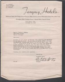
Document - BILL ASHMAN COLLECTION: CORRESPONDENCE
Four letters from Helen Tangney-Springer, Manager of the Wahkonsa Hotel, Fort Dodge, Iowa to Paul A. Douden & Company, dated November 13, 1937. Mentioned in the letter is the use of Scale Buoys in the coffee urns and the hot water tank and the difference in the cleaning of them.Letterhead - Tangney Hotelssciences, instruments - general, scalebuoy, bill ashman collection - correspondence, e c tangney, helen tangney, h h mueller, e j tangney, tangney hotels, wahkonsa hotel, muscatine hotel, arlington hotel, burke hotel, paul a douden & company, helen tangney-springer -
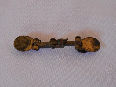 Bendigo Historical Society Inc.
Tool - BRASS OBJECT
Object. Curved brass bar with circular disc at one end. L shaped piece (broken at end) attached in centre by rivet - moveable. At either end are circular flat discs - one attached by a rivet, the other by a piece of wire - both moveable. Possibly part of a set of scales.history, australian, brass object -
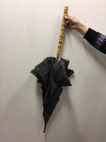 Kew Historical Society Inc
Accessory - Silk, Metal & Cane Parasol, c. 1899-1902
An item forming part of a collection of costumes, photographs and documents relating to the Weir family who owned and lived in the mansion originally named Illapa, 84 Princess Street, Kew, from 1918 to 1950. [The house is now incorporated by ‘Rylands’.] This historically significant collection includes items relating to both George Weir (1866-1937) and his wife Edith Mary Weir (1867-1948). George Weir, a person of national significance, was general manager of North Broken Hill Mine between 1903 and 1926. The collection includes a number of his patents. He married his wife, Edith Butteridge, in Broken Hill in 1891. The collection includes a number of costumes owned and worn by Edith, including her wedding dress. These costumes date from the 1880s to the 1940s and include items of outstanding aesthetic value.This parasol is significant as it is part of 26-piece collection of women’s clothing owned by Edith Mary Weir (nee Betteridge), who was born in Clare, South Australia in 1867 and who died in Kew at the age of 81 in 1948. The costumes in the donation date from the 1880s to the 1940s and constitute outstanding examples of dressmaker’s skills from each of these decades. The collection includes day dresses, evening dresses, evening coats, capes, a parasol, and undergarments. As the wife of a mining engineer, and later mine manager, Edith Weir’s clothing has historic significance as examples of clothing worn by upper middle class Australian women in domestic circumstances and at social and civic events. The costumes in the collection represent the periods when Edith Weir lived in Broken Hill, New South Wales, and in Kew, Melbourne. The garments in the Weir Collection were donated to the Kew Historical Society by the granddaughter of Edith Weir.Parasol - brown silk, pink lined with straight cane handle, owned by Edith Mary Weir (nee Betteridge) of Broken Hill, and later Princess Street, Kew. The style of the parasol, with overlapping outer 'scales' of heavy brown silk, would indicate that it was made in the late Victorian era.parasols, umbrellas, victorian fashion, weir collection -
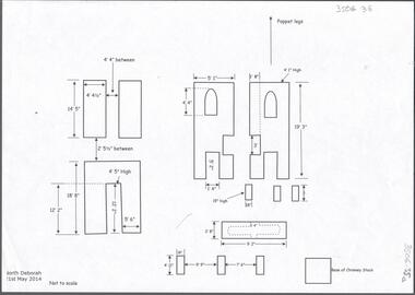 Bendigo Historical Society Inc.
Document - CENTRAL DEBORAH GOLD MINE: NORTH DEBORAH GOLD MINE
BHS CollectionSeven page document with diagrams of the remnant footings of the North Deborah Gold Mine, the South Deborah Gold Mine, Deborah Extended, Deborah Consolidated, Deborah United Deborah Associated. Measurements of footings recorded but sites are not to scale. Researched and drawn by Philip Wilkin and Kay MacGregor, 2014.bendigo, mining, central deborah gold mine -
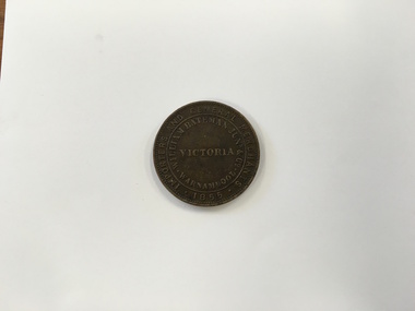 Warrnambool and District Historical Society Inc.
Coin - Token, Bateman token, 1855
This coin is a Warrnambool Bateman penny. It is an example of an Australian token – a coin that had the value of a penny and was produced by businessmen in the 1850s to be used only in the business of the person named on the coin. There were two firms in Warrnambool that produced tokens in the 1850s – William Jamieson, a general storekeeper and William Bateman. The latter had a general store in Banyan Street and became in the early 1850s one of the largest merchant firms in the Warrnambool district. But the firm’s liabilities were financed by overdrafts and insolvency resulted. A disastrous and suspicious fire in 1856 destroyed the Bateman store and caused a great number of insolvencies in the district as so many businessmen and farmers were financed by Bateman who eventually left the district. This token is of supreme importance. It is significant for three reasons: 1. It is an example of an 1850s Australian token, demonstrating an early business practice in our history. 2. It is an example of a Warrnambool token produced by an important Warrnambool business (only two firms in Warrnambool produced tokens) 3. It is a Bateman token and these are comparatively rare because many Bateman tokens were destroyed in the 1856 fire. This is an 1855 metal token with, on one side, an image of a woman holding scales in one hand and a cornucopia in the other (Dea Pecunia?). The obverse side has the name of William Bateman Junior of Warrnambool. It is a business token which could be used only in the Bateman store in Warrnambool in place of a penny.One side: Woman image and the word ‘Australia’ Obverse side: ‘William Bateman Junr. & Co., Importers and General Merchants, Warnambool (sic), Victoria, 1855’ william bateman junior, warrnambool tokens, bateman token, coin tokens -
 Bacchus Marsh & District Historical Society
Map, O'Hagan v Shire of Bacchus Marsh, Allotment 5, Sec 16, Parish of Korkuperrimul
The purpose for this map being created or the date when it was made has not been established. It appears to be documentation relating to a legal dispute by a landowner named O'Hagan and the Shire of Bacchus Marsh. Features identified on the map are allotment 5, section 16, Parish of Korkuperrimul, a 'cultivation paddock', a section of the Werribee River, the path of a section of a 'Main Channel', and a barrier or filled in section across the Werribee River called 'Lee's Filling'. The O'Hagan is likely to be Patrick O'Hagan, 1829-1914 who arrived in Bacchus Marsh in 1864 and was a prominent citizen and landowner in the area for many years until his death in 1914.Single page map showing allotment 5, section 16 in the Parish of Korkuperrimul, Scale 4 chains to inch. Part of a set of maps which are pasted into a bound volume containing 76 maps or plans in total. High resolution digital image stored on BMDHS computer network. Stamped: Munzt, Bace and Muntz, Civil Engineers and Licensed Surveyors , 388 Collins Streetbacchus marsh victoria maps, water supply structures and establishments, watercourses -
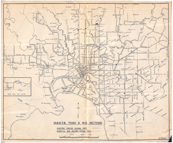 Melbourne Tram Museum
Map, Melbourne & Metropolitan Tramways Board (MMTB), "MMTB Tram and Bus Sections", mid 1960's?
Map - photocopy - titled "MMTB Tram and Bus Sections" showing tram tracks and bus routes, drawing No. P13842, c mid 1960's, Footscray and Point Ormond shown as bus. Shows railway lines, station, some cross streets. Scale 1"=1 Mile.trams, tramways, map, buses, melbourne, footscray -
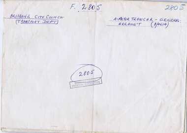 Melbourne Tram Museum
Drawing, Brisbane City Council, "Brisbane City Council - Four motor tramcar General Arrangement - 504-", c1950
Dyeline print of Brisbane City Council Drawing No. 4614, titled "Brisbane City Council - Four motor tramcar General Arrangement - 504-" scale 3/4" to 1 foot, dated 17/7/1950, providing a overall vertical and floor plan of the tramcar. Marked as F2805Has drawing title and drawing number on outside when folded and numerous Preston Workshop stamps.trams, tramways, brisbane trams, drawings -
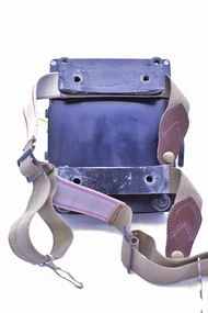 Montmorency–Eltham RSL Sub Branch
Equipment - Navigational Computer
Rectangular calculating instrument with (1) 'hinged lid' fitted with circular rotating dial for setting/reading altitude, speed, distance and temperature, (2) notebook inside lid, (3) circular dial with perspex cover, beneath which is (4) graph chart, moveable up-and-down by means of rotating knob on side of device. Curved brackets and elasticized straps on back for strapping onto pilot's leg.R.A.A.F. Ident. No. G6B/145 Serial No. WG/2233 COMPUTER NAVIGATIONAL Mk. III D. (Other inscriptions including instructions for use and scales for various measurements) "AB" hand written on strap (owner's initials?) -
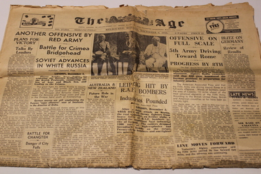 Dandenong/Cranbourne RSL Sub Branch
Memorabilia - Newspaper, The Age, The Age dated 6th Dec 1943, 6th Dec 1943
WWII Historical significance.Original edition of the Age Newspaper dated Monday 6th December 1943.Featuring historic conference at Cairo with Marshal Chiag Kai -Shek (China), President Roosevelt (USA), and Mr Churchill (Britain). Other headlines on front page are: "Plans for Victory"; "Offence On Full Scale"; "Blitz on Germany" -
Clunes Museum
Plan - PLAN OF PROPOSED ADDITIONS TO THE CLUNES BUTTER FACTORY
HAND DRAWN PLANS IN BLACK AND RED INK ON GLASS PAPER WHICH IS PINNED WITH DRESSMAKER'S PINS TO BROWN PAPER BACKING SCALE: 1 INCH TO 1 FOOT VARIOUS NOTATIONS HANDWRITTEN INCLUDES "CREATED BY HARRY E SANDO C.E. SIGNED BY ABEL GOLDSWORTHY, CONTRACTOR AND HARRY E SANDO IN BLACK INK 1 DEC 1894clunes butter factory, commercial industry in clunes -
 Ballarat Tramway Museum
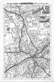
Map, Broadbent's, "Broadbent's Map 193 Bendigo", 1950s
Map of Bendigo showing streets, with the tram routes in dotted lines. Has a legend, scale and continuation maps. Gives an address of 475 Collins St Melbourne and a Melbourne telephone number - MR 2021.Yields information about Bendigo and its tram lines. Broadbents was a prolific publisher of maps. Map - single sided card, pocket map priced at 1/- - undated.bendigo, tramways, tram lines, maps, broadbents -
 Bendigo Historical Society Inc.
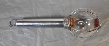
Tool - Scalebuoy
Scalebuoy. Invented by Hartley Abbott and patented under the name of the Bendigo Electronic Company, made in various sizes & for different applications, such as to prevent scaling in the boilers at mines. Part of the Aileen and John Ellison collection.Made up of a sealed glass bulb containing mercury and gasses enclosed within a chromed wire cage and with a chromed handle. The one shown being a handheld shaker model. science, bendigo electronic, abbott