Showing 32226 items
matching south-africa
-
 Bendigo Historical Society Inc.
Administrative record - Deborah Gold Mines N.L. Mine Manager's Report Book, 1930 to 1943
Deborah Gold Mines included the South Deborah, North Deborah and Deborah Extended. Deborah Gold Mines N.L. was wound up in 1950, when the shareholders, at an extraordinary meeting confirmed a proposal for voluntary liquidation. (Advertiser., Adelaide, 24 May, 1950) . George Kingsley, who wrote the reports, was the Mine Manager. He was born in Guildford in 1872, died in Bendigo in 1943. He spent his working life working in gold mines, mainly in Bendigo, in various roles, starting his work life as a blacksmith. One hundred and eighty page Mine Manager's fortnightly report book, dark blue cover, white label affixed on front with 'Deborah ....(.illegible) Minute Book' Dates from 18th July 1940 to 23rd July 1943. Entries signed by Geo Kingsley. Mine Manager's report book is part of the Margaret Roberts Collection. bendigo, gold mining, deborah gold mines, north deborah, south deborah, deborah extended, margaret roberts collection -
 Bacchus Marsh & District Historical Society
Map, Allotments in the Village of Rowsley, Parish of Gorrocburkghap, County of Grant c.1856
Rowsley is a locality 11 kilometers south-west of Bacchus Marsh. The date of this map is uncertain. A very similar map held by the State Library of Victoria (SLV) contains slightly more information than this copy and is dated as an 1856 map. SLV reference: 'Allotments in the Village of Rowsley, Parish of Gorrocburkghap, County of Grant', by T. Nixon, Assistant Surveyor, May 1856 ; Surveyor General’s Office, July 18 1856 (lithographed by R. Meikle). (1856). Melbourne: Surveyor General’s Office. MAPS 820 BJE 1837- ROWSLEY 1856. A single page paper map. A cadastral map of the Village of Rowsley in Victoria, showing numbered land allotments. 57 allotments are shown on the map and some areas set aside as reserves. Allotments 8, and 10-16 are outlined in red ink and allotment 9 has a cross in red ink on it. The map is pasted into a bound volume containing 76 maps or plans in total. High resolution digital image stored on BMDHS computer network. rowsley victoria history, rowsley victoria maps -
 Melbourne Tram Museum
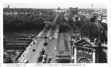
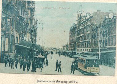
Postcard, Rose Stereograph Co, "Flinders St, Station and St Kilda Road, Melbourne", 1941
Rose Series postcard No. P 200, "Flinders St, Station and St Kilda Road, Melbourne" looking south from the roof top of the Nicholas Building in Swanston Street. Has at least eight trams in the view. The trams have a white panel under the driver's windows indicating a war time black out precaution. Has adverts for buying bonds and savings certificates and The Herald learn to Swim advertisement on the end of the verandah for Friday next January 10th at Princes Bridge. This gives a year of 1941.Yields information about St Kilda Road 1941Postcard - printed real photograph with Rose Stereograph Co. name on the rear.tramways, flinders st station, st kilda road, railways, world war ii, trams, mmtb -
 Melbourne Tram Museum
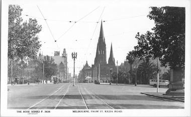
Postcard, Rose Stereograph Co, "Melbourne from St Kilda Road", late 1930s
Rose Series postcard No. P 3636, titled "Melbourne from St Kilda Road", looking north from just south of Alexandra Avenue. Note how the tram tracks are widened to pass around the center of the road light standard which appears to be marked as a tram stop. In front of the photo, a tram crossover can be seen. There is a tour bus parked at the start of Alexandra Avenue. See item 8044 for a similar view. The Edmund Fitz Gibbon Memorial is on the right in its original position in St. Kilda Road.Yields information Swanston Street and St Kilda Road in the late 1930s.Postcard - printed real photograph with Rose Stereograph Co. name on the rear.tramways, trams, st kilda road, alexandra ave -
 Melbourne Tram Museum
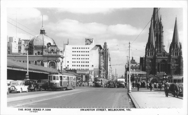
Postcard, Rose Stereograph Co, "Swanston Street Melbourne", early 1940s
Rose Series postcard No. P 3288 titled "Swanston Street Melbourne", looking north from just past (or south) of Batman Ave. There are five trams in the view and one private Reo bus. W2 class tram 452 (route 64 - City). The trams have a white strip under the driver's windows indicating the war time black out measure. The sign board advertising tram routes to Wattle Park, Burwood etc can be seen above the footpath leading to Batman Ave.Yields information about Swanston St. at the intersection with Batman Ave.Postcard - printed real photograph with Rose Stereograph Co. name on the rear.Has "K J Magor" stamp on rear.trams, tramways, w2 class, swanston st, bus, batman ave, tram 452, route 64, world war ii -
 City of Greater Bendigo - Civic Collection
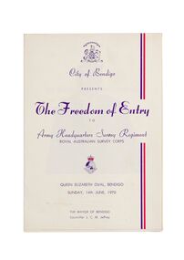
Ceremonial object - Invitation, City of Bendigo, The Freedom of Entry, 1970
On the 27th March, 1942 'Fortuna House' was occupied by LHQ Cartographic Company, Australian Survey Corps. Fortuna was the site of the base map plant and during this time approximately sixteen million maps of Australian Territories in the South West Pacific area were produced for use by the Allied Services. Fortuna was purchased in 1951 by the Commonwealth Government and until 1970 the Survey Corps and Regiment became part of community life in the district. This event to grant the Regiment Freedom of Entry took place at the Queen Elizabeth Oval on Sunday 14th June, 1970.Booklet outlining the celebrations commemorating the Army Survey Regiment's time in Bendigo. Includes a short history of the Regiment's association with the City which spanned from 1942 - 1970 as well as the day proceedings attended by the Mayor and Councillors.fortuna house, george lansell, royal aust survey corps, queen elizabeth oval, mayor jeffrey -
 Melbourne Tram Museum
Ephemera - Greetings card - Swanston St at Collins St - cable trams, Jack Cranston, c1905
Greetings card with a photo of Swanston St looking south from Collins St. On the left side of the photo is a cable tram signal shelter with a signal man at the levers. A St Kilda tram is southbound. Image prior to the construction of Flinders St station building. The Water Tower clock is visible at Princes Bridge Station - see reference. It was moved from Elizabeth St to Princes Bridge in 1902. The card was produced Jack Cranston and published for Glencon Insurance Assessors. See item 8448 for images of the card itself.Yields information about cable trams in Swanston St and a cable tram signalmen c1905.Greetings card with a colour photograph, printed on stippled paper.tramcars, tramways, cable trams, mtoco, swanston st, signalmen -
 Flagstaff Hill Maritime Museum and Village
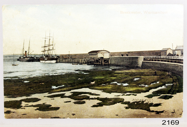
Postcard - Coastal Scene, Joseph Jordan Photographic Studio, Breakwater, Warrnambool, circa 1907
The Port of Warrnambool - In the early years the Port of Warrnambool was a busy port. Steamships and sailing ships were frequent visitors to the port. Steam navigation companies were plentiful, carrying passengers and freighting cargo such as coal, timber, food, livestock, furniture, hardware and haberdashery between Melbourne and the ports along the southwest coast of Victoria, including Warrnambool. The carts would take their loads into the township for distribution. The Breakwater was built (using 32 ton blocks of concrete) between 1874 and 1890 to provide ships with greater protection from the Southern Ocean. The Lifeboat and Rocket House - The coastline of South West Victoria has had over 600 shipwrecks and many lost lives; even in Warrnambool’s Lady Bay there were around 16 known shipwrecks between 1850 and 1905, with eight lives lost. In 1859 the first Government-built lifeboat arrived at Warrnambool Harbour and a shed was soon built to house it, followed in 1864 by a rocket house to safely store the Rocket Rescue equipment. In 1878 the buildings were moved to the Breakwater area, and in 1910 the new Lifeboat Warrnambool arrived with its ‘self-righting’ design. For almost one hundred years the lifeboat and rocket crews, mostly local volunteers, trained regularly to maintain and improve their skills, summoned when needed by alarms, gunshots, ringing bells and foghorns. Some became local heroes but all served an important role. By the end of the 1950s the lifeboat and rescue equipment had become obsolete. Joseph Jordan - Joseph Jordan was born in 1841 in Leicester England. When he was 16 he joined the 7th Queen's Own Hussars and was sent to India at the outbreak of the mutiny. He took part in the relief of Lucknow and remained in India for eleven years. It was during this time, he became interested in photography. He was posted to New Zealand and later came to Victoria, becoming a sergeant major of the Mounted Rifles. In the mid 1880s he came to the Western district where he was responsible for establishing units of the Mounted Rifles in various country towns such as Dunkeld, Mortlake, Panmure, Bushfield, Koroit etc. He resigned from the army in 1889 and set up a professional photography studio in Liebig Street, Warrnambool. He became very well known in the Western District for family photographs, official photographs of local councillors and groups as well as views of local scenery. In 1891 he photographed the wrecked barque "Fiji" at "Wrecks Beach" near Princetown. His business was taken over by his son Arthur around 1917. Joseph was a keen rifle shot and in 1924 he donated the "Jordan Shield" as a prize to the Victorian Rifle Association. He was made a "Life Honorary Member" of the Warrnambool Returned Soldiers League and in 1933 he was recognised as being the oldest living soldier in Victoria. Joseph died in 1935 aged 95. Valentine Publishing Company Pty. Ltd. Valentine and Sons was a printing and photography business based in Dundee, Scotland and Canada. In the early 1900's, at the height of the postcard craze, they published large numbers of postcards in the U.K., Canada, U.S., Australia and South Africa. Valentine postcards have a 6 digit serial number on the view side with the initials "J. V." in a circle adjacent to the number. The 300,000's related to views of Australia. From around 1900 (or earlier) the firm bought many images for their postcards from local and national photographers who sold publishing rights to Valentines.This postcard is significant for its association with the Port of Warrnambool and the Warrnambool Breakwater as it shows a point in time when shipping activities were an important part of Warrnambool's commerce and social development. It is also a record of the Warrnambool Lifeboat and Rocket house which was important in aiding ordinary citizens, harbour employees and the volunteer boat and rescue crew in saving the lives of sailors and passengers due to the high number of shipwrecks that occurred along the coastline. Joseph Jordan is a significant figure in Warrnambool history as he helped to establish early units of the Mounted Rifles (G Company) in local towns during the late 1880's and later, photographed local scenes, groups and citizens of early Warrnambool. It is also a culturally significant example of the type of postcards that were very popular in the early part of the 20th century.Photograph of breakwater from beachFront of card - Breakwater, Warrnambool / 300,025 J.V [in a circle] Back of card - POSTCARD / VALENTINE'S SERIES / - This space may be used for communication / The address only to be written here - Miss Alice Griffen / Howard St / Warrnambool - How are you enjoying your holiday we are grand. / from / Dodo, Dodo, Dodo with love - Leura? / Marjory Craig? / BL006 / R99A / REG NO 2169flagstaff hill, warrnambool, shipwrecked-coast, flagstaff-hill, flagstaff-hill-maritime-museum, maritime-museum, photograph, warrnambool breakwater, breakwater, shipwreck-coast, flagstaff-hill-maritime-village, warrnambool harbour, postcard, joseph jordan, valentine and sons, valentine publishing company, lady bay, life boat house, rocket house, steam ship, barque, jordan photography -
 The Beechworth Burke Museum
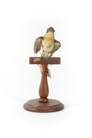
Animal specimen - Satin Flycatcher, Trustees of the Australian Museum, 1860-1880
The Satin Flycatcher is a small and energetic bird commonly found along the east coast of Australia from far northern Queensland to Tasmania. They are also located in south-eastern South Australia and New Guinea. These birds prefer to reside in tall forests and are fond of wetter habitats like forested gullies but not rainforests. These birds are dimorphic, meaning male and females have distinct forms. The male Satin Flycatcher is blue-black in colouring while the female are brown-grey with a distinct orange band on the chin, neck and breast. This specimen is part of a collection of almost 200 animal specimens that were originally acquired as skins from various institutions across Australia, including the Australian Museum in Sydney and the National Museum of Victoria (known as Museums Victoria since 1983), as well as individuals such as amateur anthropologist Reynell Eveleigh Johns between 1860-1880. These skins were then mounted by members of the Burke Museum Committee and put-on display in the formal space of the Museum’s original exhibition hall where they continue to be on display. This display of taxidermy mounts initially served to instruct visitors to the Burke Museum of the natural world around them, today it serves as an insight into the collecting habits of the 19th century.This specimen is part of a significant and rare taxidermy mount collection in the Burke Museum. This collection is scientifically and culturally important for reminding us of how science continues to shape our understanding of the modern world. They demonstrate a capacity to hold evidence of how Australia’s fauna history existed in the past and are potentially important for future environmental research. This collection continues to be on display in the Museum and has become a key part to interpreting the collecting habits of the 19th century.This female Satin Flycatcher is stylised on a wooden platform with a paper tag attached to its leg. This specimen has small glass eyes, wings positioned to its sides and a long straight tail. The colouring on this bird is a brown-grey and cream colour. It has patch of orange feathers on the neck and chin which identify the gender of this specimen. The male has glossy blue-black colouring and lack the orange plumage.33A. / Shining Flycatcher - See Catalogue, Page 13. / 50 /taxidermy mount, taxidermy, animalia, burke museum, beechworth, australian museum, skin, reynell eveleigh johns, bird, australian birds, satin flycatcher, small bird, flycatcher -
 Kiewa Valley Historical Society
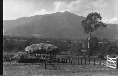
Photograph - Mt Bogong - Tawonga, 06/05/1937
Mount Bogong located in the Alpine National Park and part of the Victorian Alps of the Great Dividing Range, is the highest mountain in Victoria, Australia, at 1,986 metres (6,516 ft) above sea level. The Big River separates the massif of the mountain from the Bogong High Plains to the south. From the nearby town of Mount Beauty to its summit, Mount Bogong rises more than 1,600 metres (5,200 ft), thus making it one of the highest peaks in Australia not only in terms of its elevation above sea level, but also in terms of actual base-to-summit prominence. Mount Bogong is a popular backcountry skiing mountain through winter but only has snow for the mid winter-spring months. It is around 30 kilometres (19 mi) by road and walking track or 12 kilometres (7.5 mi) direct to Mount Beauty. Falls Creek and Mount Hotham ski resorts are also nearby. Camping is relatively safe below the tree line but the summit ridgeline is very exposed. Emergency shelter is also available at Bivouac Hut on the Staircase Spur, and at Cleve Cole, above Camp Creek on the broad ridge to the south of the summit, and Michells Hut on the Eskdale Spur. Mt Bogong is a popular recreational venue in the Kiewa Valley for back country skiing and bush walking and is a favourite with sightseers and popular subject for photographersBlack and white photograph of Mt bogong taken from Tawonga - Thursday May 6th, 1937Handwritten on back of photograph. Thursday May 6th, 1937. Mt Bogong Tawongamt bogong, tawonga, kiewa valley -
 Eltham District Historical Society Inc
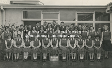
Photograph, Classic Photos, Form 3A, Eltham High School, 1960
Dr Gary Presland advised the following in October 2020: "In 1959 my parents bought a house in Church Street, Panton Hill. For about three and a half years previously, they had farmed a property 15 km south of Echuca, before moving, briefly to Melbourne. After moving to Panton Hill, I was enrolled at Eltham HS, in Form 2 (Year 8). I completed that year, and in 1960 was in Form 3A (at which time the photograph was taken). To reach the school, I caught a bus each day, from Panton Hill. Early in 1960, my parents decided to separate. My mother left with the youngest two of my three siblings, leaving me and a younger brother with our father in Panton Hill. My brother was in Year 7 at the High School. After a few months, my father and I had a falling out and my brother and I left home to join our mother in South Melbourne. For the remainder of the 1960 school year we travelled each day by train from Melbourne to Eltham. In 1961 I was enrolled at Melbourne Boys High School, which was the nearest secondary school to where I was then living."Written in pencil on back: "Gary Presland - 4th from left, back row Eltham HS, 1960" Also stamped in purple ink on back "Classic Photos"1960, class photo, eltham high school, gary presland -
 Kiewa Valley Historical Society
Black and White photograph of Road Making Machinery, Kiewa Road Making, 25/08/1938
Construction of the main road from South Tawonga to the Bogong High Plains, to provide access to the construction sites for the new Kiewa Hydro Electric Scheme, was commenced early in 1938, the work being undertaken on behalf of the Commission by the Country Roads Board. For the construction work, the Commission purchased three Caterpillar - model R07 - diesel crawler tractors equipped with Kay Brunerei (Brunner) hydraulically operated trailbuilders (angle dozers). This acquisition resulted from a visit to the United States of America in May, 1937 by the Construction Engineer ( Mr. C.H. Kernot) and Assistant Civil Engineer (Mr. J.F. Douglas) where they saw this relatively new type of equipment in use. With the co-operation of the CRB, the Commission demonstrated the operation of these machines at Fishermen's Bend on 6th April, 1938. They were then sent to Kiewa where they commenced operation towards the end of the month. From South Tawonga, the route led immediately across the Western Branch of the Kiewa River necessitating the construction of a bridge 100 feet long. By the end of 1939, the excavation had been 'opened up' for a distance of 19 1/2 miles (approx. 31 km) and of this length, 10 miles (approx. 16 km) had been surfaced.The purchase and use of this type of mechanical equipment in road making was a huge investment, as prior to this most of the work would have been done manually with the use of picks and shovels. Not only were many months of hard manual labour saved, but a very significant amount of time in providing access to the proposed work sites for the new Kiewa Hydro Scheme. This photo is an excellent reminder of how primitive the early machinery was compared to the present but also represents the forward thinking of the State Electricity Commissions engineers in purchasing such innovative equipment . A black and white photograph showing the type of machinery used for road making in the 1930's. It shows a grader being towed by a caterpillar tractor.On the top left hand corner of the photograph , hand written in black ink is the words 'Kiewa Road Making 25/8/1938'. On the right hand side of the photo has been stamped in blue the Number 1. It has been developed on Velox paper (marked on back of photo) with a gloss finish.road making, state electricity commission, caterpillar tractor, kiewa -
 Kiewa Valley Historical Society
Black and White photograph of Road Making Machinery, Kiewa Road Making 25/08/1938 No. 2, 25/08/1938
Construction of the main road from South Tawonga to the Bogong High Plains, to provide access to the construction sites for the new Kiewa Hydro Electric Scheme, was commenced early in 1938, the work being undertaken on behalf of the commission by the Country Roads Board. For the construction work, the Commission purchased three Caterpillar - model R07 - diesel crawler tractors equipped with Kay Brunerei (Brunner) hydraulically operated trailbuilders (angle dozers). This acquisition resulted from a visit to the United States of America in May, 1937 by the Construction Engineer ( Mr. C.H. Kernot) and Assistant Civil Engineer ( Mr. J.F. Douglas) where they saw this relatively new type of equipment in use. With the co-operation of the CRB, the Commission demonstrated the operation of these machines at Fishermen's Bend on 6th April, 1938. They were then sent to Kiewa where they commenced operation towards the end of the month. From South Tawonga, the route let immediately across the Western Branch of the Kiewa River necessitating the construction of a bridge 100 feet long. By the end of 1939, the excavation had been 'opened up' for a distance of 19 1/2 miles (approx. 31 km.) and of this length, 10 miles (approx. 16 km.) had been surfaced. (see KVHS 0328)The purchase of this type of mechanical equipment in road making was a huge investment, as prior to this most of the work would have been done manually with the use of picks and shovels. Not only were many months of hard manual labour saved, but a very significant amount of time in providing access to the proposed work sites for the new Kiewa Hydro Scheme. This photo is an excellent reminder of how primitive the early machinery was compared to the present but also represents the forward thinking of the State Electricity Commissions engineers in purchasing such innovative equipment.A black and white photograph of road making near Mt. Beauty in 1938. Mount Beauty hills can be seen in the background with cleared land for grazing in the fore ground.Hand printed in black ink at the top of the photograph is 'Kiewa Road Making 25/8/1938'. On the right hand corner has been printed the number 2. It has been printed on gloss Velox paper.road making, state electricity commission, caterpillar tractor, kiewa, secv -
 Kiewa Valley Historical Society
Black and White photograph of Road Making Machinery, Kiewa Road Making 25/8/1938(No. 3 in a series of 8), 25/08/1938
Construction of the main road from South Tawonga to the Bogong High Plains, to provide access to the construction sites for the new Kiewa Hydro Electric Scheme, was commenced early in 1938, the work being undertaken on behalf of the Commission by the Country Roads Board. For the construction work, the Commission purchased three Caterpillar - model R07 - diesel crawler tractors equipped with Kay Brunerei (Brunner) hydraulically operated trail builders (angle dozers)). This acquisition resulted from a visit to the United States of America in May, 1937 by the Construction Engineer ( Mr. C.H. Kernot) and Assistant Civil Engineer (Mr. J.F. Douglas) where they saw this relatively new type of equipment in use. With the co-operation of the CRB, the Commission demonstrated the operation of these machines at Fishermen's Bend on 6th April, 1938. They were then sent to Kiewa where they commenced operation towards the end of the month. From South Tawonga, the route led immediately across the Western Branch of the Kiewa River necessitating the construction of a bridge 100 feet long. By the end of 1939,the excavation had been 'opened up' for a distance of 19 1/2 miles (approx. 31 km.) and of this length, 10 miles (approx. 16 km) had been surfaced.The purchase and use of this type of mechanical equipment in road making was a huge investment, as prior to this most of the work would have been done manually with the use of picks and shovels. Not only were many months of hard manual labour saved, but a very significant amount of time in providing access to the proposed work sites for the new Kiewa Hydro Scheme. This photo is an excellent reminder of how primitive the early machinery was compared to the present but also represents the forward thinking of the State Electricity Commission's Engineers in purchasing such new and innovative equipment.A black and white photograph of a Caterpillar diesel crawler tractor and a hydraulically operated trailbuilder (angle dozer) making a road in the Mt. Beauty area.Hand written in black ink in the top left hand corner are the words "Kiewa Road Making 25/8/1938". On the upper right hand of the photograph has been stamped the number 3. On the back is stamped the word 'Velox' severaly times, which is the make of the photograhic paper. roadmaking, caterpillar tractor, kiewa, state electricity commission -
 Flagstaff Hill Maritime Museum and Village
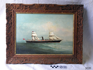
Painting - Vessel, C.K.M. (artist), S.S. Warrnambool, 1883
This oil painting is in a handmade, carved frame, dates back to the period of the old Warrnambool Museum and Art Gallery. The two-masted, sail-and-steam-powered ship has the sails and bow shape of a tall clipper ship plus the extra power of steam. It dates to the transition between the clipper ships with their billowing sails and the steam-powered ships, which happened in the late 19th to early 20th century. The flag flown from the stern is that of the British Merchant Navy that traded around the world to transport cargo, and later passengers, from one destination to another. The painting was originally catalogued as the "S.S. Warrnambool" although it has a different design. It was also attributed to the ship portrait painter, the renowned C.K.M. - Charles Keith Miller - but differs from his style. Further research is being carried out at this time. In 1966, between the closure of the old Warrnambool Museum and Art Gallery and the distribution of the painting to Flagstaff Hill, this painting was repaired by David Heysen, son of the German-born artist Hans Heysen OBE. David was born in Hahndorf (called Ambleside for a short period of time), South Australia, married Lyly Refshauge from Melbourne, and they raised a family on their property in Kalangadoo, near Penola, in South Australia.The painting's frame is an example of handmade carving and joinery created in the late 19th century. The artist has depicted the image of a historical sail-and-steam ship of the type in which cargo was traded across the world, including to and from Australia. Vessels such as this also brought migrants to Australia.Painting, oil on board, in hand carved wooden frame with floral and geometric pattern, inner border painted gold. Image of a two-masted sail and steam ship, sails raised, black funnel emitting smoke. Hull is black with white horizontal stripe and white trim around sides of deck. Three lifeboats are visible. Bow is ‘clipper shape’ with what appears to be a figurehead. A red ensign flag flies at the stern and a blue and red flag is attached to the mainmast. The frame has been assembled using Mortice and Tenon joints, one of which is exposed on the back, lower right corner. Chandelier chain has been attached for hanging. There is no visible signature, date or title on the front of the painting. The back board has empty holes spaced around the edge and is held in place by staples. The visible surface has remnants of adhesive from two rectangular attachment s. There are two small white stickers attached, one with a hand written inscription. There are pencil and pen inscriptions. The painting is protected by cardboard with inscriptions in marking pen.On back board, written in the style used by the Warrnambool Museum and Art Gallery: - On white sticker, in pen “A-P31/1-74” - Pencil “A27/1883 / Artist CKM 1883 / Title SS Warrnambool / oil on board” Written in pen by the repairer - “Repaired & re-drilled – cleaned etc. / David Heysen 11/66” Written by Flagstaff Hill’s Cataloguer - Pencil “3031” On cardboard wrapper, in marking pen: - “S.S. Warrnambool / by / C.K.M. 1883” - “A-P/31/1-74” - “3031”flagstaff hill, warrnambool, shipwrecked coast, maritime museum, shipwreck coast, flagstaff hill maritime village, great ocean road, s s warrnambool, charles keith miller, charles miller, steam and sail ship, british merchant navy, slipper shaped bow, 19th century sea trade, warrnambool museum and art gallery, old warrnambool art gallery, hand carved picture frame, mortice and tennon picture frame, migrants, c.k.m. -
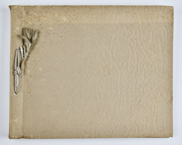
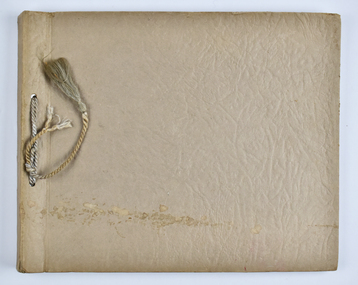
 National Wool Museum
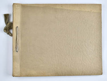
Album - Photo Album, 1 of 3, J W Allen, 1928-1929
This album is one of three albums compiled and owned by J W Allen, Secretary of New South Wales Grazier's, and is associated with the New South Wales Graziers Association world tour of sheep 1928-1929. This album contains photographs of travel, sheep, farms, stations, people and landscapes from around the world. Locations include Naples, Port Said, Suez, Birregurra (Vic), Alexandra (Vic), Ballangeich (Vic), Keith (SA), Mt Gambier (SA), Buckland Park (SA), Tasmania, Winton (QLD), Sydney Harbour, Canberra (ACT), Toowoomba (QLD), Rockhampton (QLD), Tocal (NSW), Deepwater (NSW), Glen Innes (NSW), Longreach (QLD), Moree (NSW), Barraba (NSW) and Mudgee (NSW). Properties depicted include Mooleric, Turkeith, Woolongoon, Minadale, Crower Station, Merrindie, Koomooloo Station, Cappeedee, Koonoona, Rathmore, Ellenthorpe, Camden Park Station, Glenlegh, Strathmore Station, Ilparran Station, Binneguy, Midkin, Terlings, Ashley, Bereen, Plumthorpe, Mayvale and Havilah. The album was found in a clean out at the Great Southern Agricultural Research Institute and donated to the National Wool Museum, along with other related material such as photographs, glass lantern slides and ephemera.Photo album with card cover and silk string binding. Inside are twenty four pages of brown carded paper with black and white photos and hand written black text. A white piece of paper with hand written text has been added to the inside front page.new south wales graziers association, world tour, sheep, farm, rural, agriculture, stations, mooleric, turkeith, woolongoon, minadale, crower, merrindie, koomooloo, cappeedee, koonoona, rathmore, ellenthorpe, camden park, glenlegh, strathmore, ilparran, binneguy, midkin, terlings, ashley, bereen, plumthorpe, mayvale, havilah, naples, port said, suez, birregurra, alexandra, ballangeich, keith, mt gambier, buckland park, tasmania, winton, sydney, canberra, toowoomba, rockhampton, tocal, deepwater, glen innes, longreach, moree, barraba, mudgee, merino -
 National Wool Museum
Album - Photo Album, 2 of 3, J W Allen, 1928-1929
This album is one of three albums compiled and owned by J W Allen, Secretary of New South Wales Grazier's, and is associated with the New South Wales Graziers Association world tour of sheep 1928-1929. This album contains photographs of travel, sheep, farms, stations, people and landscapes from around the world. Locations include Kenya, Kinangop, Naivasha, Elementeita, Lake Nakuru, Njoro, Namibia, Otjihavera, Mt Kenya, Isiolo, Yemen, Aden, Suez, River Jordan, Jerusalem, Hebron, Bethlehem, Beersheba, Galilee, Lake Tiberias, Mt Hermon, Canada, Mt Robson, Fraser River Canyon, British Columbia, Merrit, Canford, Alberta, Cardston, Pekisko Creek, Turner Valley, Calgary, Saskatoon, Manitoba, Winnipeg, Portage la Prairie, Niagara Falls, Quebec, Sainte-Anne-de-la-Pocatière and St Lawrence River. Properties depicted include Kenton Estates, Kekopey Ranch, Soysambu Ranch, Larmudiac, SX Ranch, Neilson's Ranch, EP Ranch and CX Ranch. The album was found in a clean out at the Great Southern Agricultural Research Institute and donated to the National Wool Museum, along with other related material such as photographs, glass lantern slides and ephemera.Photo album with card cover and silk string binding. Inside are twenty four pages of brown carded paper with black and white photos and hand written black text. A white piece of paper with hand written text has been added to the inside front page.new south wales graziers association, world tour, sheep, farm, rural, agriculture, ranch, travel, kenton estates, kekopey ranch, soysambu ranch, larmudiac, sx ranch, neilson's ranch, ep ranch, cx ranch, kenya, kinangop, naivasha, elementeita, lake nakuru, njoro, namibia, otjihavera, mt kenya, isiolo, yemen, aden, suez, river jordan, jerusalem, hebron, bethlehem, beersheba, galilee, lake tiberias, mt hermon, canada, mt robson, fraser river canyon, british columbia, merrit, canford, alberta, cardston, turner valley, pekisko creek, calgary, saskatoon, manitoba, winnipeg, portage la prairie, niagara falls, quebec, sainte-anne-de-la-pocatiere, st lawrence river -
 National Wool Museum
Album - Photo Album, 3 of 3, J W Allen, 1928-1929
This album is one of three albums compiled and owned by J W Allen, Secretary of New South Wales Grazier's, and is associated with the New South Wales Graziers Association world tour of sheep 1928-1929. This album contains photographs of travel, sheep, farms, stations, people and landscapes from around the world. Locations include Warren (NSW), Molong (NSW), Gamboola (NSW), Forbes (NSW), Hay (NSW), Conargo (NSW), Mokine (WA), New Zealand, Hawke's Bay, Southland, Lyttleton Harbour, Rotorua, Christchurch, Lincoln, Banks Peninsula, Akaroa, Pigeon Bay, Darfield, Rakahuri, Kaiwara, Highbank, Lake Heron, Mt Somers, Otago, Moa Flat, Waimahaka, Tarras, Moeraki and Blenheim. Properties depicted include Haddonrig, Egelabra, Bundemar, Redbank, Wandary, Tubbo Station, Coonong Station, Boonoke Station, Wanganella Estate, Yoorooga Estate, Taruna Farm, Harpenden Wool Works, Keppoch Estate, Bushey Park, Morven Downs, Meadowbank, Te Apiti and Penrose Farm. The album was found in a clean out at the Great Southern Agricultural Research Institute and donated to the National Wool Museum, along with other related material such as photographs, glass lantern slides and ephemera.Photo album with card cover and silk string binding. Inside are twenty four pages of brown carded paper with black and white photos and hand written black text. A white piece of paper with hand written text has been added to the inside front page.new south wales graziers association, world tour, sheep, farm, rural, agriculture, travel, new zealand, warren, molong, gamboola, forbes, hay, conargo, mokine, hawke's bay, southland, lyttleton, rotorua, christchurch, lincoln, banks peninsula, akoroa, pigeon bay, darfield, rakahuri, kaiwara, highbank, lake heron, mt somers, otago, moa flat, waimahaka, tarras, moeraki, blenheim, haddonrig, egelabra, bundemar, redbank, wandary, tubbo station, coonong station, boonoke station, wanganella estate, yoorooga estate, taruna farm, harpenden wool works, keppoch estate, bushey park, morven downs, meadowbank, te apiti, penrose farm -
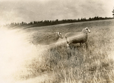 National Wool Museum
Photograph - Border Leicesters, J W Allen, 1928-1929
This photograph was found loose in the third of three albums compiled and owned by J W Allen, Secretary of New South Wales Grazier's, and is associated with the New South Wales Graziers Association world tour of sheep 1928-1929. The album contains photographs of travel, sheep, farms, stations, people and landscapes from around the world. Locations include Warren (NSW), Molong (NSW), Gamboola (NSW), Forbes (NSW), Hay (NSW), Conargo (NSW), Mokine (WA), New Zealand, Hawke's Bay, Southland, Lyttleton Harbour, Rotorua, Christchurch, Lincoln, Banks Peninsula, Akaroa, Pigeon Bay, Darfield, Rakahuri, Kaiwara, Highbank, Lake Heron, Mt Somers, Otago, Moa Flat, Waimahaka, Tarras, Moeraki and Blenheim. Properties depicted include Haddonrig, Egelabra, Bundemar, Redbank, Wandary, Tubbo Station, Coonong Station, Boonoke Station, Wanganella Estate, Yoorooga Estate, Taruna Farm, Harpenden Wool Works, Keppoch Estate, Bushey Park, Morven Downs, Meadowbank, Te Apiti and Penrose Farm. The album was found in a clean out at the Great Southern Agricultural Research Institute and donated to the National Wool Museum, along with other related material such as photographs, glass lantern slides and ephemera.Black and white image showing two sheep in a field.Back: [handwritten] Low, Highbank / Border ♀♀ / [printed] 68world tour, sheep, graziers, photograph, border leicester sheep -
 National Wool Museum
Photograph - Karakul Sheep, J W Allen, 1928-1929
This photograph was found loose in the second of three albums compiled and owned by J W Allen, Secretary of New South Wales Grazier's, and is associated with the New South Wales Graziers Association world tour of sheep 1928-1929. The album contains photographs of travel, sheep, farms, stations, people and landscapes from around the world. Locations include Kenya, Kinangop, Naivasha, Elementeita, Lake Nakuru, Njoro, Namibia, Otjihavera, Mt Kenya, Isiolo, Yemen, Aden, Suez, River Jordan, Jerusalem, Hebron, Bethlehem, Beersheba, Galilee, Lake Tiberias, Mt Hermon, Canada, Mt Robson, Fraser River Canyon, British Columbia, Merrit, Canford, Alberta, Cardston, Pekisko Creek, Turner Valley, Calgary, Saskatoon, Manitoba, Winnipeg, Portage la Prairie, Niagara Falls, Quebec, Sainte-Anne-de-la-Pocatière and St Lawrence River. Properties depicted include Kenton Estates, Kekopey Ranch, Soysambu Ranch, Larmudiac, SX Ranch, Neilson's Ranch, EP Ranch and CX Ranch. The album was found in a clean out at the Great Southern Agricultural Research Institute and donated to the National Wool Museum, along with other related material such as photographs, glass lantern slides and ephemera.Black and white image showing sheep in a paddock.world tour, sheep, graziers, photograph, karakul, winnipeg, canada, manitoba, agriculture -
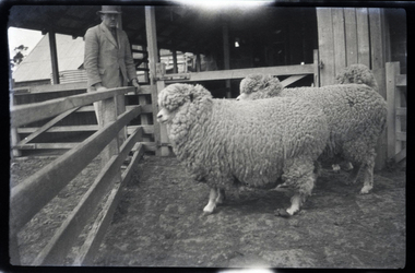
 National Wool Museum
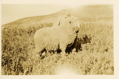
Photograph - 'Harvey' Ram at Neilson's Ranch, J W Allen, 1928-1929
This photograph was found loose in the second of three albums compiled and owned by J W Allen, Secretary of New South Wales Grazier's, and is associated with the New South Wales Graziers Association world tour of sheep 1928-1929. The album contains photographs of travel, sheep, farms, stations, people and landscapes from around the world. Locations include Kenya, Kinangop, Naivasha, Elementeita, Lake Nakuru, Njoro, Namibia, Otjihavera, Mt Kenya, Isiolo, Yemen, Aden, Suez, River Jordan, Jerusalem, Hebron, Bethlehem, Beersheba, Galilee, Lake Tiberias, Mt Hermon, Canada, Mt Robson, Fraser River Canyon, British Columbia, Merrit, Canford, Alberta, Cardston, Pekisko Creek, Turner Valley, Calgary, Saskatoon, Manitoba, Winnipeg, Portage la Prairie, Niagara Falls, Quebec, Sainte-Anne-de-la-Pocatière and St Lawrence River. Properties depicted include Kenton Estates, Kekopey Ranch, Soysambu Ranch, Larmudiac, SX Ranch, Neilson's Ranch, EP Ranch and CX Ranch. The album was found in a clean out at the Great Southern Agricultural Research Institute and donated to the National Wool Museum, along with other related material such as photographs, glass lantern slides and ephemera.Black and white image showing a man and a sheep in the foreground with mountains in the background.Back: [handwritten] Harvey ram / at Neilson’s / Harvey / Neilson’s ranch [printed] A 40world tour, sheep, graziers, photograph, canada, agriculture, cardtson, alberta -
 National Wool Museum
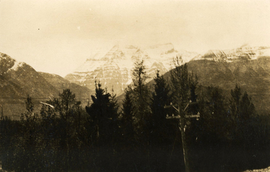
Photograph - Mount Robson, J W Allen, 1928-1929
This photograph was found loose in the second of three albums compiled and owned by J W Allen, Secretary of New South Wales Grazier's, and is associated with the New South Wales Graziers Association world tour of sheep 1928-1929. The album contains photographs of travel, sheep, farms, stations, people and landscapes from around the world. Locations include Kenya, Kinangop, Naivasha, Elementeita, Lake Nakuru, Njoro, Namibia, Otjihavera, Mt Kenya, Isiolo, Yemen, Aden, Suez, River Jordan, Jerusalem, Hebron, Bethlehem, Beersheba, Galilee, Lake Tiberias, Mt Hermon, Canada, Mt Robson, Fraser River Canyon, British Columbia, Merrit, Canford, Alberta, Cardston, Pekisko Creek, Turner Valley, Calgary, Saskatoon, Manitoba, Winnipeg, Portage la Prairie, Niagara Falls, Quebec, Sainte-Anne-de-la-Pocatière and St Lawrence River. Properties depicted include Kenton Estates, Kekopey Ranch, Soysambu Ranch, Larmudiac, SX Ranch, Neilson's Ranch, EP Ranch and CX Ranch. The album was found in a clean out at the Great Southern Agricultural Research Institute and donated to the National Wool Museum, along with other related material such as photographs, glass lantern slides and ephemera.Black and white image showing trees, power pole and power lines in the foreground and snow covered mountains in the background. world tour, sheep, graziers, photograph, canada, agriculture, british columbia, mount robson, mt robson -
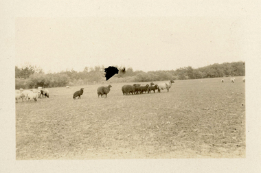
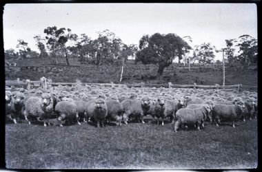
 National Wool Museum
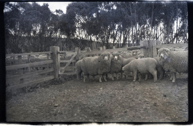
Negative - Sheep, J W Allen, 1928-1929
This negative was found loose in the first of three albums compiled and owned by J W Allen, Secretary of New South Wales Grazier's, and is associated with the New South Wales Graziers Association world tour of sheep 1928-1929. The album contains photographs of travel, sheep, farms, stations, people and landscapes from around the world. Locations include Naples, Port Said, Suez, Birregurra (Vic), Alexandra (Vic), Ballangeich (Vic), Keith (SA), Mt Gambier (SA), Buckland Park (SA), Tasmania, Winton (QLD), Sydney Harbour, Canberra (ACT), Toowoomba (QLD), Rockhampton (QLD), Tocal (NSW), Deepwater (NSW), Glen Innes (NSW), Longreach (QLD), Moree (NSW), Barraba (NSW) and Mudgee (NSW). Properties depicted include Mooleric, Turkeith, Woolongoon, Minadale, Crower Station, Merrindie, Koomooloo Station, Cappeedee, Koonoona, Rathmore, Ellenthorpe, Camden Park Station, Glenlegh, Strathmore Station, Ilparran Station, Binneguy, Midkin, Terlings, Ashley, Bereen, Plumthorpe, Mayvale and Havilah. The album was found in a clean out at the Great Southern Agricultural Research Institute and donated to the National Wool Museum, along with other related material such as photographs, glass lantern slides and ephemera.Black and white negative showing sheep in stockyards with trees and hill in background.agriculture, sheep, farming, stations, research, breeding, photography, travel -
 National Wool Museum
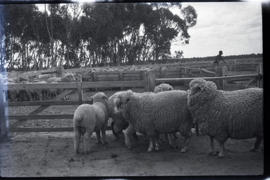
Negative - Sheep in Stockyards, J W Allen, 1928-1929
This negative was found loose in the first of three albums compiled and owned by J W Allen, Secretary of New South Wales Grazier's, and is associated with the New South Wales Graziers Association world tour of sheep 1928-1929. The album contains photographs of travel, sheep, farms, stations, people and landscapes from around the world. Locations include Naples, Port Said, Suez, Birregurra (Vic), Alexandra (Vic), Ballangeich (Vic), Keith (SA), Mt Gambier (SA), Buckland Park (SA), Tasmania, Winton (QLD), Sydney Harbour, Canberra (ACT), Toowoomba (QLD), Rockhampton (QLD), Tocal (NSW), Deepwater (NSW), Glen Innes (NSW), Longreach (QLD), Moree (NSW), Barraba (NSW) and Mudgee (NSW). Properties depicted include Mooleric, Turkeith, Woolongoon, Minadale, Crower Station, Merrindie, Koomooloo Station, Cappeedee, Koonoona, Rathmore, Ellenthorpe, Camden Park Station, Glenlegh, Strathmore Station, Ilparran Station, Binneguy, Midkin, Terlings, Ashley, Bereen, Plumthorpe, Mayvale and Havilah. The album was found in a clean out at the Great Southern Agricultural Research Institute and donated to the National Wool Museum, along with other related material such as photographs, glass lantern slides and ephemera.Black and white negative showing sheep in stock yards, with trees in background. A man is shown standing in the yards to the right hand side. agriculture, sheep, farming, stations, research, breeding, photography, travel -
 National Wool Museum
Negative - Sheep, J W Allen, 1928-1929
This negative was found loose in the first of three albums compiled and owned by J W Allen, Secretary of New South Wales Grazier's, and is associated with the New South Wales Graziers Association world tour of sheep 1928-1929. The album contains photographs of travel, sheep, farms, stations, people and landscapes from around the world. Locations include Naples, Port Said, Suez, Birregurra (Vic), Alexandra (Vic), Ballangeich (Vic), Keith (SA), Mt Gambier (SA), Buckland Park (SA), Tasmania, Winton (QLD), Sydney Harbour, Canberra (ACT), Toowoomba (QLD), Rockhampton (QLD), Tocal (NSW), Deepwater (NSW), Glen Innes (NSW), Longreach (QLD), Moree (NSW), Barraba (NSW) and Mudgee (NSW). Properties depicted include Mooleric, Turkeith, Woolongoon, Minadale, Crower Station, Merrindie, Koomooloo Station, Cappeedee, Koonoona, Rathmore, Ellenthorpe, Camden Park Station, Glenlegh, Strathmore Station, Ilparran Station, Binneguy, Midkin, Terlings, Ashley, Bereen, Plumthorpe, Mayvale and Havilah. The album was found in a clean out at the Great Southern Agricultural Research Institute and donated to the National Wool Museum, along with other related material such as photographs, glass lantern slides and ephemera.Black and white negative showing sheep in stockyards with trees and a power pole in the background. agriculture, sheep, farming, stations, research, breeding, photography, travel -
 National Wool Museum
Negative - Sheep, J W Allen, 1928-1929
This negative was found loose in the first of three albums compiled and owned by J W Allen, Secretary of New South Wales Grazier's, and is associated with the New South Wales Graziers Association world tour of sheep 1928-1929. The album contains photographs of travel, sheep, farms, stations, people and landscapes from around the world. Locations include Naples, Port Said, Suez, Birregurra (Vic), Alexandra (Vic), Ballangeich (Vic), Keith (SA), Mt Gambier (SA), Buckland Park (SA), Tasmania, Winton (QLD), Sydney Harbour, Canberra (ACT), Toowoomba (QLD), Rockhampton (QLD), Tocal (NSW), Deepwater (NSW), Glen Innes (NSW), Longreach (QLD), Moree (NSW), Barraba (NSW) and Mudgee (NSW). Properties depicted include Mooleric, Turkeith, Woolongoon, Minadale, Crower Station, Merrindie, Koomooloo Station, Cappeedee, Koonoona, Rathmore, Ellenthorpe, Camden Park Station, Glenlegh, Strathmore Station, Ilparran Station, Binneguy, Midkin, Terlings, Ashley, Bereen, Plumthorpe, Mayvale and Havilah. The album was found in a clean out at the Great Southern Agricultural Research Institute and donated to the National Wool Museum, along with other related material such as photographs, glass lantern slides and ephemera.Black and white negative showing three sheep in stockyards with a man standing to the left. agriculture, sheep, farming, stations, research, breeding, photography, travel -
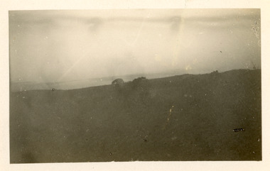 National Wool Museum
Photograph - Landscape, J W Allen, 1928-1929
This photograph was found loose in the first of three albums compiled and owned by J W Allen, Secretary of New South Wales Grazier's, and is associated with the New South Wales Graziers Association world tour of sheep 1928-1929. The album contains photographs of travel, sheep, farms, stations, people and landscapes from around the world. Locations include Naples, Port Said, Suez, Birregurra (Vic), Alexandra (Vic), Ballangeich (Vic), Keith (SA), Mt Gambier (SA), Buckland Park (SA), Tasmania, Winton (QLD), Sydney Harbour, Canberra (ACT), Toowoomba (QLD), Rockhampton (QLD), Tocal (NSW), Deepwater (NSW), Glen Innes (NSW), Longreach (QLD), Moree (NSW), Barraba (NSW) and Mudgee (NSW). Properties depicted include Mooleric, Turkeith, Woolongoon, Minadale, Crower Station, Merrindie, Koomooloo Station, Cappeedee, Koonoona, Rathmore, Ellenthorpe, Camden Park Station, Glenlegh, Strathmore Station, Ilparran Station, Binneguy, Midkin, Terlings, Ashley, Bereen, Plumthorpe, Mayvale and Havilah. The album was found in a clean out at the Great Southern Agricultural Research Institute and donated to the National Wool Museum, along with other related material such as photographs, glass lantern slides and ephemera.Black and white photograph depicting a landscape. back: [handwritten] E / Maryvale / [printed] VELOXagriculture, sheep, farming, stations, research, breeding, photography, travel -
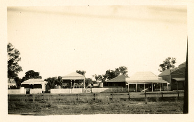 National Wool Museum
Photograph - A Queensland Town, J W Allen, 1928-1929
This photograph was found loose in the first of three albums compiled and owned by J W Allen, Secretary of New South Wales Grazier's, and is associated with the New South Wales Graziers Association world tour of sheep 1928-1929. The album contains photographs of travel, sheep, farms, stations, people and landscapes from around the world. Locations include Naples, Port Said, Suez, Birregurra (Vic), Alexandra (Vic), Ballangeich (Vic), Keith (SA), Mt Gambier (SA), Buckland Park (SA), Tasmania, Winton (QLD), Sydney Harbour, Canberra (ACT), Toowoomba (QLD), Rockhampton (QLD), Tocal (NSW), Deepwater (NSW), Glen Innes (NSW), Longreach (QLD), Moree (NSW), Barraba (NSW) and Mudgee (NSW). Properties depicted include Mooleric, Turkeith, Woolongoon, Minadale, Crower Station, Merrindie, Koomooloo Station, Cappeedee, Koonoona, Rathmore, Ellenthorpe, Camden Park Station, Glenlegh, Strathmore Station, Ilparran Station, Binneguy, Midkin, Terlings, Ashley, Bereen, Plumthorpe, Mayvale and Havilah. The album was found in a clean out at the Great Southern Agricultural Research Institute and donated to the National Wool Museum, along with other related material such as photographs, glass lantern slides and ephemera.Black and white photograph showing a row of buildings, with a fence in the foreground and trees in the background. back: [handwritten] B / A Queensland town – main street / from train. / Note houses on [?} – white ants / & cooleragriculture, sheep, farming, stations, research, breeding, photography, travel -
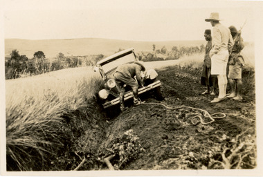 National Wool Museum
Photograph - Car Stuck, Keringet, Kenya, J W Allen, 1928-1929
This photograph was found loose in the first of three albums compiled and owned by J W Allen, Secretary of New South Wales Grazier's, and is associated with the New South Wales Graziers Association world tour of sheep 1928-1929. The album contains photographs of travel, sheep, farms, stations, people and landscapes from around the world. Locations include Naples, Port Said, Suez, Birregurra (Vic), Alexandra (Vic), Ballangeich (Vic), Keith (SA), Mt Gambier (SA), Buckland Park (SA), Tasmania, Winton (QLD), Sydney Harbour, Canberra (ACT), Toowoomba (QLD), Rockhampton (QLD), Tocal (NSW), Deepwater (NSW), Glen Innes (NSW), Longreach (QLD), Moree (NSW), Barraba (NSW) and Mudgee (NSW). Properties depicted include Mooleric, Turkeith, Woolongoon, Minadale, Crower Station, Merrindie, Koomooloo Station, Cappeedee, Koonoona, Rathmore, Ellenthorpe, Camden Park Station, Glenlegh, Strathmore Station, Ilparran Station, Binneguy, Midkin, Terlings, Ashley, Bereen, Plumthorpe, Mayvale and Havilah. The album was found in a clean out at the Great Southern Agricultural Research Institute and donated to the National Wool Museum, along with other related material such as photographs, glass lantern slides and ephemera.Black and white photograph showing a car stuck on a muddy road. A man is shown tying a rope to the front of a car with three people standing to the right. back: [handwritten] Near Keringet[?] / Stevens, Jardine[?] / Mem[?] / 3 / [printed] Veloxagriculture, sheep, farming, stations, research, breeding, photography, travel -
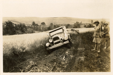 National Wool Museum
Photograph - Car Stuck, Keringet, Kenya, J W Allen, 1928-1929
This photograph was found loose in the first of three albums compiled and owned by J W Allen, Secretary of New South Wales Grazier's, and is associated with the New South Wales Graziers Association world tour of sheep 1928-1929. The album contains photographs of travel, sheep, farms, stations, people and landscapes from around the world. Locations include Naples, Port Said, Suez, Birregurra (Vic), Alexandra (Vic), Ballangeich (Vic), Keith (SA), Mt Gambier (SA), Buckland Park (SA), Tasmania, Winton (QLD), Sydney Harbour, Canberra (ACT), Toowoomba (QLD), Rockhampton (QLD), Tocal (NSW), Deepwater (NSW), Glen Innes (NSW), Longreach (QLD), Moree (NSW), Barraba (NSW) and Mudgee (NSW). Properties depicted include Mooleric, Turkeith, Woolongoon, Minadale, Crower Station, Merrindie, Koomooloo Station, Cappeedee, Koonoona, Rathmore, Ellenthorpe, Camden Park Station, Glenlegh, Strathmore Station, Ilparran Station, Binneguy, Midkin, Terlings, Ashley, Bereen, Plumthorpe, Mayvale and Havilah. The album was found in a clean out at the Great Southern Agricultural Research Institute and donated to the National Wool Museum, along with other related material such as photographs, glass lantern slides and ephemera.Black and white photograph showing a car stuck on a muddy road. Two men are standing to the right hand side. back: [handwritten] Near Keringet[?] / [printed] Veloxagriculture, sheep, farming, stations, research, breeding, photography, travel