Showing 253 items
matching prospecting
-
 Bendigo Historical Society Inc.
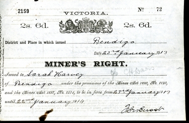
Legal record - WES HARRY COLLECTION: THREE MINER'S RIGHT / RESIDENCY PERMITS
The Miner’s Right has a long history in Australia. Still in use today, it was first established in Victoria in 1855, as a replacement for the Gold License (which had been introduced in Victoria in 1851). The Miner’s Right was subsequently adopted by other Australian colonies. Unlike the Gold License, the early Miner’s Right, in addition to the right to prospect for gold, also carried with it certain other advantages, such as property rights and voting rights. The Miner’s Right came about as a recommendation of a government-appointed commission, which had been appointed on 1854 to look into the troubles on the Victorian goldfields, especially regarding the Eureka Rebellion.Three Miner's Rights / Residency Permits for leases on the corner of Holdsworth Road and Wood Street, Long Gully, Bendigo (Area known as American Gully - downstream of the American Mine): a and b No 72 Sarah Harvey, dated 23/01/1913 c and d No 23148 Evalina Gifford Vivian Harvey, dated 14/09/1926 e and f No 23149 Thomas George Harvey, dated 14/09/1926 Issued by the Victorian Government at a cost of two shillings and six penceVictorian State Governmentwes harry collection, miner's right, bendigo, history, long gully bendigo -
 Federation University Historical Collection
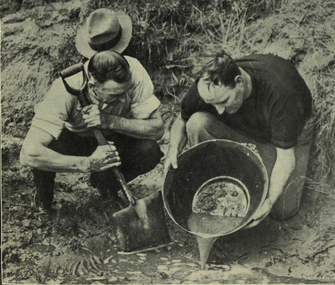
Photograph - black and white, Panning Off
... prospecting ...Photograph included in book "Victoria: Gold and Minerals" issued by Mines Department Victoria, 1935Image of two men involved in panning for gold. victoria, gold mining, prospecting method, creek bed, panning, gold panning, gold pan, mining, prospecting, tools -
 Truganina Explosives Reserve Preservation Society Inc (TERPS)
Digitised Oral History – Truganina Explosives Reserve - Tape 11 Rob Andrew, 2018
The interviews were recorded in 2000 by Bronwen Gray and Alan Young for the production of Unreserved, Stories from Truganina Explosives Reserve, animated stories from past residents, workers and interested people of the Reserve (subject to copyright 2004). Rob Andrew’s career was as an Environmental Health Officer with various councils around Victoria. As an Altona resident he became interested in the Truganina Explosives Reserve when he heard the site was to be sold. He was concerned that because of the prospect of commercial development the community would lose tranquil open parklands. Through his involvement with the Reserve he realised the historical, geomorphic, flora and fauna significance of the site. A primary source of information on memories of the Truganina Explosives Reserve and Altona,VictoriaDigital copy of original cassette recorded in 2000 and digitised in 2018native grasses, explosives, cheetham wetlands, cheetham salt works, doug grant, chirnside, cliff gibson, lava plain, brown coal, sand ridges, selwyn fault, rowsley fault, victorian coastal strategy, aboriginal stone artefacts, aboriginal habitation, aboriginal remains, red gums, casuarinas, altona skipper butterfly, orange bellied parrot -
 Bendigo Historical Society Inc.
Document - RAE'S CRUSHING BATTERY - THE RICH VICTORIA HILL & ITS HISTORICAL ASSOCIATIONS
The first five pages are photocopies of photos:- 2 of Rae's Crushing Works; Victoria Quartz on Victoria Hill, Ironbark; Looking North from Old Chum Hill to the Victoria Hill; Victoria Hill - from Rae's Open Cut. Introduction covers location of buildings and mines. Mentioned are:- North Old Chum Mine, Ballerstedt's First Open-cut, Quartz Veins (Spurs), rock formations pitching North, Prospecting shafts 1929, Concrete dam, Engine beds of Lansells Big 180 Mine, Lansells Big 180 Shaft, twenty stampers crushing battery, Lansell's Cleopatra Needle type chimney, Victoria Quartz Mine, Victoria Quartz dams, Rae's Open-cut, Quartz once roasted here to an intense heat, Anticlinal Arch New Chum Line, small primitive tunnels, Prospecting tunnels, Floyd's small 5 head crushing battery, Great Central Victoria (Midway) Shaft, Great Central Victoria engine-bed, Ballerstedt's small 24 yard claim, The Humboldt, Adventure ground, The Advance, Luffsman & Sterry's Claim, A round shaft. Small piece of paper with 'Notes on Victoria Hill complete.document, gold, rae's crushing battery, rae's crushing battery, rae's crushing works, victoria quartz mine, from old chum hill, victoria hill from rae's open cut, ironbark, hercules & energetic, midway, wittscheibe, great central victoria, mr & mrs conroy, central nell gwynne, gold mines hotel, john brown knitwear factory, new chum & victoria, rotary club of bendigo south, north old chum, ballerstedt's first open-cut, lansell's big 180 shaft, cleopatra needle type chimney, a roberts & sons, mr e j dunn, h harkness & sons, eureka extd, new chum railway, pearl, inrush of water at victoria quartz, floyd's small 5 head crushing battery, great central victoria (midway), ballertedt's small 24 yard claim, humboldt, humboldt, great central victoria, victoria hill, bendigo & vicinity 1895 p51, j n macartney 1st edition 1871, bendigo goldfield registry 1871, plan of new chum line, mr rae anderson, annals of bendigo obituary 1904, bendigo advertiser, b m l records mines dept, patterson's goldfields of victoria, dickers mining record 23/11/1861, australian mining standard special edition 1/6/1899 p40, bendigo mines ltd, chinese joss house, fortuna, the victoria goldfield 1851 to 1954, the victoria hill 1854 to 1949 -
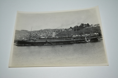 Wangaratta RSL Sub Branch
Photograph, SS Orduna
On 12 August 1940, SS Orduna sailed from Liverpool with a privately organised party of 16 children from Belmont Preparatory school, Hassocks Sussex to Nassau. It was part of a wider British Government children's evacuation program during World War II, when the prospect of imminent invasion threatened Britain. In 1941 with the need for military transport in the Second World War, she was put into service by the British government as a troopship. Another task during the Second World War was that of an evacuation transport. In 1945 the Orduna brought back Prisoners of War and internees from the Far East. A memorial to the ships involved in the repatriation was unveiled on the Liverpool waterfront on 15 October 2011. Black and white photograph of ship at sea alongside populated coastline.In pencil on rear - SS Orduna - We escorted her from Panama to Valparaisoss orduna, ww2 -
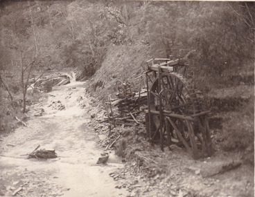 The Beechworth Burke Museum
Postcard, 1920
This postcard depicts the set-up of an abandoned gold mine. This includes a water wheel and other mining implements next to a creek. The postcard inscription indicates that this image is of the remains of the Wallaby Reef battery and water wheel. Wallaby Reef was discovered in 1864, and a prospecting claim established a four head battery and water wheel. Quartz was mined there, with gold also discovered at this location at a later date. By 1878 the mine was no longer resulting in rich deposits, this resulted in the miners moving their search for gold closer to the river where they were able to access more gold. This was in approximately 1879. In 1882 a rich deposit was found. In 1908 the battery was closed, and the mine finished. This photo was taken in 1920 and shows the deterioration of the site since its closure. Gold mining was crucial to the development of the Beechworth area. It has strong research and historical value because the clarity of the photo shows all the minute details of the mining equipment. The text on the back also indicates the mine is the Wallaby Mine, which was used for 45 years to find gold and quartz. Therefore, due to the location being quickly abandoned, this site is a rich location for historical study on gold mining during the 1900s. It can provide important information on the types of tools utilised and the impact of the mining on the environment.Black and white postcard photograph on card.8169 Be / Also near Wallaby Reef Workings / Relics of Rechabite Reef (locality) workings. / Shaft in bed of creek. Wheel used to drive sheadd (?) / stamp battery too I believe near B'worth 1920?beechworth, mining, gold mining, quartz mining, wallaby reef mine, mine battery head -
 Cinema and Theatre Historical Society of Australia Inc.
CINEMARECORD NO 97 March 2018
CINEMARECORD ISSUE 97 March 218 ARTICLES IN THIS EDITION Life Memberships Awards Errata CinemaRecord # 96 Fire at the Mentone Theatre Proserpine’s Eldorado Theatres The Astra, Ascot Park, SA Cinemas of Orange NSW Happy Days at Hoyts Movies Gulgong’s Prince of Wales Opera House My Fair Lady Theatre, Adelaide Plaza Theatre / Paris Theatre, Perth Prince of Wales, Hobart Then and Now - Prospect SA When CinemaScope came to Australia Smoke Gets in Your Eyes Looking Back … The Regent and Plaza, Melbourne Perth Theatre Advertising 1982 -
Glenelg Shire Council Cultural Collection
Photograph - Sheet of 12 contact prints - Various historic Portland buildings and Landmarks, c. 1970
Sheet of 12 contact prints of rephotographed photographs. Identifying numbers 5726 a, b, c, d, e, f, g, h, i, j, k, l (a) S.S. 'Dawn' at Railway Pier (b) Macs Hotel (c) Dr. C. Grier, Res. Julia Street (d) Bentinck Street, South from All Saints (e) Captain James Fawthrop (f) Bridge over Salt Creek (g) 'Prospect' (h) 'Windsor Cottage' (i) Bentinck Street from sea (j) London Hotel (k) 'Greenmount' (l) British fleet at anchor in Portland BayFront: (b) Macs Hotel (l) British fleet in portland Bay, Sept 30 1891 CN-865-G -
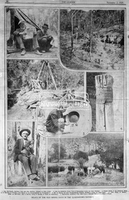 Eltham District Historical Society Inc
Negative - Photograph, The Leader, Relics of the Old Mining days in the Queenstown District, 2 Nov 1929
Queenstown (St. Andrews) District. Originally published in The Leader, Nov. 2nd, 1929, p30, with the title "Relics of the Old Mining days in the Queenstown District," a series of seven numbered photographs with captions : 1. Two Old-Timers, Brothers Tom and Alex McPhee, Camped on Back Creek. 2. Like the Caledonia, Every Yard of Queenstown Creek has been Washed. 3. Poppet Heads of the Caledonia Mine. 4. A Warning to Possible Land Buyers or Encouragement to Prospectors? 5. Mr. A. Harvey has been Prospecting the District, Washing a Loam, for Some Years. 6. John Olsen, of Smith's Gully, an Old-Timer, who is Shortly Going to Norway to Claim an Inheritance. 7. Queenstown Cemetery. - The Hills Form a Splendid Memorial to Many a Digger.This photo forms part of a collection of photographs gathered by the Shire of Eltham for their centenary project book,"Pioneers and Painters: 100 years of the Shire of Eltham" by Alan Marshall (1971). The collection of over 500 images is held in partnership between Eltham District Historical Society and Yarra Plenty Regional Library (Eltham Library) and is now formally known as the 'The Shire of Eltham Pioneers Photograph Collection.' It is significant in being the first community sourced collection representing the places and people of the Shire's first one hundred years.Digital image 4 x 5 inch B&W Negsepp, shire of eltham pioneers photograph collection, queenstown, gold mining, a. harvey, alex mcphee, back creek, caledonia mine, john olsen, poppet heads, queenstown cemetery, queenstown creek, smiths gully, st. andrews, tom mcphee -
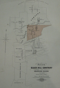 Federation University Historical Collection
Plan, Plan of the Black Hill Company & Adjoining Claims
Plan of the Black Hill Company & Adjoining Claims. The No 1 Queen claim has been shaded in a buff colour. Scale 300 feet to one inch (1:3600) Shows Dan Brophy's Shaft, Red's Shaft, Two Ton Shaft, Shows the following prospecting company's claims: The Black Hill Company, No. 3 Queen, No. 1 Queen, North Sulieman Pasha, Sulieman, Duchess Co, Parade Co, Pasha Co, Sulieman Pasha Co, Llanberris Co Shows the following streets: Clissold Street, Peel Street, Victoria Street, Humffray Street, Princes Street, Wills Street, King Streetblack hill company, black hill, niven, f.w. niven, sulieman, duchess company, llanberris, cgt -
 Kew Historical Society Inc
Plan - Subdivision Plan, Goldthorns Hill Estate, 1925
Pru Sanderson, in her groundbreaking ‘City of Kew Urban Conservation Study : Volume 2 - Development History’ (1988), summarised the periods of urban development and subdivisions of land in Kew. The periods that she identified included 1845-1880, 1880-1893, 1893-1921, 1921-1933, 1933-1943, and Post-War Development. These periods were selected as they represented periods of rapid growth or decline in urban development. An obvious starting point for Sanderson’s groupings involved population growth and the associated economic cycles. These cycles also highlighted urban expansion onto land that was predominantly rural, although in other cases it represented the decline and breakup of large estates. A number of the plans in the Kew Historical Society’s collection can also be found in other collections, such as those of the State Library of Victoria and the Boroondara Library Service. A number are however unique to the collection.The Kew Historical Society collection includes almost 100 subdivision plans pertaining to suburbs of the City of Melbourne. Most of these are of Kew, Kew East or Studley Park, although a smaller number are plans of Camberwell, Deepdene, Balwyn and Hawthorn. It is believed that the majority of the plans were gifted to the Society by persons connected with the real estate firm - J. R. Mathers and McMillan, 136 Cotham Road, Kew. The Plans in the collection are rarely in pristine form, being working plans on which the agent would write notes and record lots sold and the prices of these. The subdivision plans are historically significant examples of the growth of urban Melbourne from the beginning of the 20th Century up until the 1980s. A number of the plans are double-sided and often include a photograph on the reverse. The Goldthorns Hill Estate subdivision was first put up for auction in 1925. The subdivision took its name from the mansion ‘Goldthorns’, shown on the plan between Normanby Road and Lady Loch’s Drive. Contemporary advertisements describe forty-three home sites being fro sale, yet only forty-one appear on this plan. Buyers were lured by the prospect of the proposed extension of the Burke Road tram to High Street. Discerning buyers were advised that only one house could be built per allotment, and that houses needed to be constructed of brick, stone or concrete and have a slate or tiled roof.goldthorns avenue -- kew east (vic.), lady loch drive -- kew east (vic.), argyle road -- kew east (vic.), lady brassey drive -- kew east (vic.), campbell street -- kew east (vic.), goldthorns -- kew (vic.), subdivisions -- kew east (viv.), goldthorns hill estate -
 Warrnambool and District Historical Society Inc.
Document: Cuttings, Warrnambool Steam Packet Company, C 1890
THis collection of cuttings relates to the Warrnambool Steam Packet Company.The Warrnambool Steam Packet Company was established in 1868 when capital was raised with 2000 shares at a value of five pounds each.It was established to provide passenger, accommodation and a large stock and freight service between Warrnambool and Melbourne.. At the time Stephen Henty was operating three steamers along the coast and at the prospect of losing his Warrnambool trade with the establishment of the new Warrnambool company, he sold one of his steamers , the Edina in March 1868. The first five directors elected were F P Stevens, J G Crammond, WW Jamieson, R B Paterson and George Wood. Fares were from one to three pounds and freight was 17 shillings per ton.The steamers connected with coaches from the north of Warrnambool as far as Hamilton. The cuttings record the financial position of the company for the first ten years. This collection of cuttings is valuable as a research item as it documents the development and operation as well as many of the stake holders in one of Warrnambool's earliest shipping companies. The cuttings are from a range of papers including The Warrnambool, Examiner, The Warrnambool Advertiser and the Argus.Ledger book with blue pages which is lacking the cover. It contains a number of cuttings which relate to the Steam Packet Company.Dated on first page: Monday November 1st 1869. Most of the cuttings are dated and some are from the Examiner. the Advertiser and Warrnambool Standard.warrnambool, warrnambool steam packet company, edina -
 Bendigo Historical Society Inc.
Slide - DIGGERS & MINING. THE DIGGINGS THE DIGGERS, c9 Sep 1852
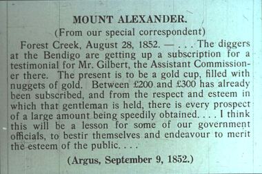
Diggers & Mining. The Diggings The Diggers. Slide: MOUNT ALEXANDER. (From our special correspondent) Forest Creek, August 28, 1852. - . . . The diggers at the Bendigo are getting up a subscription for a testimonial for Mr. Gilbert, the Assistant Commissioner there. The present is to be a gold cup, filled with nuggets of gold. Between 200 pounds and 300 pounds has already been subscribed, and from the respect and esteem in which that gentleman is held, there is every prospect of a large amount being speedily obtained . . . I think this will be a lesson for some of our government officials, to bestir themselves and endeavour to merit the esteem of the public. . . . (Argus, September 9, 1852.) Markings: 77 994.LIF:4. Used as a teaching aid.hanimounteducation, tertiary, goldfields -
 Eltham District Historical Society Inc
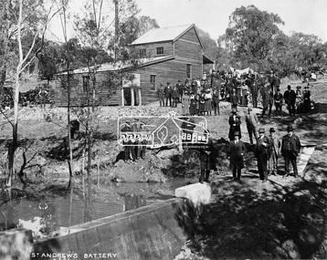
Negative - Photograph, Opening of St. Andrews Battery, Queenstown, 29 Aug. 1919
Reproduced on p31 of 'Pioneers & Painters' Was destroyed in 1962 bushfire. Now Peter Franks Reserve, St Andrews On Friday 29th (August 1919) …, the Hon. S. Barnes, M. L. A., Minister of Mines, accompanied by Mr W. Everard, M.L.A., Mr. V. Dickson, secretary for Mines, and Mr. Merrin, Chief Mining Inspector, visited Smith's Gully for the purpose of opening, the new Government battery which has recently been erected. The party arrived punctually at 12.30, and was received by an assemblage of about 200 residents, including, those representing local prospecting and mining interests. At the mill house the Minister wished prosperity to mining on the old Queenstown field, and, in a few appropriate remarks, gave the battery the name of St. Andrew's. Then, as the stamps began to fall, three hearty cheers were given by the gathering. ….. The Queenstown field, dating back to the early sixties, might be regarded as a link that took them back to the Augustine age of gold mining in Victoria…From 1868 to 1918 the total yield of gold from the field was 274,606 fine oz. It might be that here, as elsewhere, deeper prospecting would give new life to the Queenstown goldfield. The miners of Queenstown, who through long year's had never lost faith in the possibilities of the field, felt that the purpose for which they were that day marked the beginning of a new era in the history of local reefing. …. The new mill is situated on the bank of the creek opposite the Queenstown Cemetery, and consists of a five head battery (Berdan pan) and 12 h.p. portable steam engine housed in a spacious structure of wood and iron. A concrete weir across the creek provides a good water supply, and all the necessary pumps, settling dams, etc., have been installed. Later on, should circumstances warrant it, it is pro-posed to erect Wilfley tables for concentrates. Eltham and Whittlesea Shires Advertiser and Diamond Creek Valley Advocate, Friday 5 September 1919, page 3This photo forms part of a collection of photographs gathered by the Shire of Eltham for their centenary project book,"Pioneers and Painters: 100 years of the Shire of Eltham" by Alan Marshall (1971). The collection of over 500 images is held in partnership between Eltham District Historical Society and Yarra Plenty Regional Library (Eltham Library) and is now formally known as the 'The Shire of Eltham Pioneers Photograph Collection.' It is significant in being the first community sourced collection representing the places and people of the Shire's first one hundred years.Digital image 4 x 5 inch B&W Neg Print 20 x 25 (2)shire of eltham pioneers photograph collection, queenstown, st andrews, st. andrews battery, gold mining, s. barnes, merrin, st andrews battery, v. dickson, william h. everard, peter franks reserve -
 Bendigo Military Museum
Administrative record - Geodetic Survey and Topographical Mapping in Australia - Report by BP Lambert 1968, 1968
Australia is governed by a Federal Government and by six State Governments. National coordination of their respective geodetic survey and topographic mapping activities is effected on the advice of a National Mapping Council. Twenty years ago, at least 95% of Australia was poorly mapped and what maps existed were in need of revision. only a small area of the continent was covered by horizontal geodetic control and there was no scheme for a national levelling survey. Over the intervening period there has been an urgent and increasing demand for topographic maps varying from large scale contoured maps in support of specific engineering projects to rapid reconnaissance maps required for mineral prospecting in remote areas. Superimposed on this has been a defence requirement, specifically for military training areas, and generally for maps of the whole country. During the period much progress has been made. This paper reports on the progress from early colonial days through to the present time and finally hazards a prediction of future trends.Photocopy of 18-page typed report including diagrams, stapled top left-hand corner. Geodetic Survey and Topographic Mapping a Report by BP Lambert Director of National Mapping, Department of National Development, Canberra, Australia, 1968.royal australian survey corps, rasvy, fortuna, army survey regiment, army svy regt, asr, national mapping -
 Bendigo Historical Society Inc.
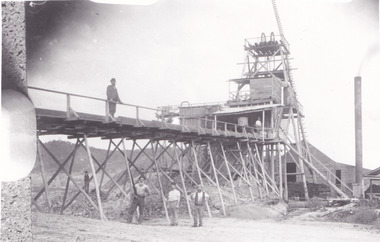
Book - CENTRAL DEBORAH MINE CORRESPONDENCE RE PLANT DEVELOPMENT PART 2
Black folder containing photocopied documents pertaining to the setting up and running of the Central Deborah Mine, Bendigo. 1939 - 1948. Original copies held in McColl,Rankin & Stanistreet Collection. Application for Permit. Ministry of Post War Reconstruction. War Organisation of Industry. Quotes, Tenders. Hume & Iser. T.J Jorgensen. Electricity Supply Department. Saunders & Ross. District Telephone Office. R Toma. Stock Exchange. Building Site Plan. Abbott Supply Co. F.W. Milne & Son. The Golden City Agricultural Implements. Department of Labour and National Service.Miller & Co. Thompson Engineering and Pipe Co. Gold Boring and Prospecting. Costs. J.l. Howard. A.J. William Electrical Instruments.bendigo, mining, central deborah gold mine -
Bendigo Historical Society Inc.
Map - MINING REPORTS - PLAN OF CHEWTON GOLDFIELD 1937
Plan of the Chewton Goldfield with Scale Measurement in chains. Plan shows the township of Chewton with the reefs and leases, the railway line and the Main Castlemaine - Melbourne Road. Also the Eureka Vineyard. Issued by The Stock Exchange of Melbourne, April 1937. Leases named are: Central Wattle Gully, Wattle Gully United, Wattle Gully Extended, South Wattle Gully, Golden Wattle, Chewton, White Horse, Wattle Gully, North Wattle Gully, North Chewton, Upper Barkly, Post Office Hill, Misima United, Argus Hill, Chapmans, Chewton Prospecting Co, Fiji Gold & Gold Mines of Fiji and Nimrod. Stamp in the top right corner: Edward Dyason & Co. - Queen St. Melbourne. Sharebrokers.map, mining reports, plan of chewton goldfield, edward dyason & co, the stock exchange of melbourne, central wattle gully, wattle gully united, wattle gully extended, south wattle gully, golden wattle, chewton, white horse, wattle gully, north wattle gully, north chewton, upper barkly, post office hill, misima united, argus hill, chapmans, chewton prospecting co, fiji gold & gold mines of fiji, nimrod -
 Kew Historical Society Inc
Plan, Melbourne & Metropolitan Board of Works : Borough of Kew : Detail Plan No.1585, 1904
The Melbourne and Metropolitan Board of Works (MMBW) plans were produced from the 1890s to the 1950s. They were crucial to the design and development of Melbourne's sewerage and drainage system. The plans, at a scale of 40 feet to 1 inch (1:480), provide a detailed historical record of Melbourne streetscapes and environmental features. Each plan covers one or two street blocks (roughly six streets), showing details of buildings, including garden layouts and ownership boundaries, and features such as laneways, drains, bridges, parks, municipal boundaries and other prominent landmarks as they existed at the time each plan was produced. (Source: State Library of Victoria)This plan forms part of a large group of MMBW plans and maps that was donated to the Society by the Mr Poulter, City Engineer of the City of Kew in 1989. Within this collection, thirty-five hand-coloured plans, backed with linen, are of statewide significance as they include annotations that provide details of construction materials used in buildings in the first decade of the 20th century as well as additional information about land ownership and usage. The copies in the Public Record Office Victoria and the State Library of Victoria are monochrome versions which do not denote building materials so that the maps in this collection are invaluable and unique tools for researchers and heritage consultants. A number of the plans are not held in the collection of the State Library of Victoria so they have the additional attribute of rarity.Original survey plan, issued by the MMBW to a contractor with responsibility for constructing sewers in the area identified on the plan within the Borough of Kew. The plan was at some stage hand-coloured, possibly by the contractor, but more likely by officers working in the Engineering Department of the Borough and later Town, then City of Kew. The hand-coloured sections of buildings on the plan were used to denote masonry or brick constructions (pink), weatherboard constructions (yellow), and public buildings (grey). This plan, which covers parts of High Street, Pakington Street and Derby Street is dominated by two historic Kew mansions: ‘Konetta’ and ‘Ramornie’. Ramornie was constructed in 1890 for James Maitland Campbell, three times Mayor of Kew. Sold in 1940, it became a boarding house known as ‘The Towers’. Now a private residence again, it has only one of its three balconies remaining. The location of the missing two balconies can be seen on the plan. In 1903, the grounds of Ramornie included a large tennis court fronting Pakington Street. The rear of the property is shown as extending to Cobden Street. One of Kew’s oldest hotels, the Prospect Hill Hotel on the corner of High and Cobden Street was established in 1858. The outline of the hotel shown on the plan represents the second building on the site. During the 19th century it was often used for electoral meetings. The Prospect Hill Hotel was to be redeveloped again in 1928, by the local architect Robert McIntyre. Since the 1980s, the hotel has been a live music venue, the home of the Melbourne Jazz Club, a restaurant and a liquor outlet.melbourne and metropolitan board of works, detail plans, maps - borough of kew, mmbw 1585, cartography -
 Bendigo Historical Society Inc.
Document - MCCOLL, RANKIN AND STANISTREET COLLECTION: NORTH VIRGINIA GOLD MINING CO NL, 1933
McColl Rankin & Stanistreet, North Virginia Gold Mining Co NL. a/ Agreement dated 13/1/1933 Claim No. 115, mining right transfer from Harold John Veale to J J Hall, J A Michelson, J J Stanistreet & H J Leed owners of lease No. 10027. b/ Consent To Grant Of Lease, Quartz Prospecting Claim or otherwise 13/1/1933. Lease No. 10027 Signed by H J Veale in the presence of ?? Leed (p1). Leslie Veale partner of Harold John Veale Claim No. 115 authorizes H J Veale to act on his behalf to transfer the claim to New Virginia Syndicate. Signed by Leslie Veale (p2). Transfer Of Claim etc. to New Virginia Syndicate all right title and interest in Quartz Prospecting Claim numbered 115 known as Paddys Gully line of reef West of Neanger Mine at Sailors Gully Eaglehawk. Signed H J Veale Miner's No. 70059 dated 3/8/1933 (p3). c/ Agreement, North Virginia Mining Company NL application for mining leases from the Crown Numbers 10027 & 10150 Bendigo about 30 acres in Sailors Gully Eaglehawk and Bendigo and a company is intended to be formed and incorporated called North Virginia Gold Mining Company No Liability. Signatures: J J Hall, E D Doyle, J J Stanistreet, E R Grelis, Albert Beischer, J B Young. 3 sheets. d/ Duplicate of 2205.156corganization, business, gold mine, mccoll rankin & stanistreet, north virginia gold mining co nl claim no. 115, mining right transfer quartz prospecting claim transfer new virginia syndicate mining right transfer 1933 lease no. 10027 claim no 115 paddys gully neanger mine e/h bendigo -
 Melton City Libraries
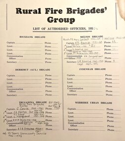
Document, Rural Fire Brigade's Group, c.1950
From the earliest days of settlement in the shire, residents demonstrated their willingness to band together in times of crisis and need. "Bushfires were always a terrifying prospect and since its establishment in 1935, the local fire brigade (later the Country Fire Authority) fought hard to protect the people, homes and animals of the shire. In 1966, the Mount Cottrell Fire Brigades Group was formed as a way of consolidating the smaller groups around Melton, Rockbank, Toolern Vale, Sydenham, Truganina and Werribee. Its headquarters were established at the home of Ernest ‘Bon’ and Edna Barrie in Ferris Road, Melton. Captain Bon Barrie was a member of the Melton Fire Brigade and elected group and communications officer of the new Mount Cottrell Brigades Group.22 Wendy Barrie, daughter of Edna and Bon, remembers the fire truck parked at their house and her mother operating the fire brigade’s radio. Growing up in the fire station headquarters, Wendy and her siblings learned how to use the radio too, in case of emergencies".Rural Fire Brigade's Group List of Authorised Officers including the captains and lieutenantsemergency services -
 The Beechworth Burke Museum
Photograph, 1857
This photograph is of old mine workings on the site of the Spring Creek diggings. Spring Creek is a contact zone for granite pluton and siltstones, shales and standstones; which has, over time, encouraged natural springs to form. Enriched with gold washed out of the surrounding granite, these alluvial deposits achieved fame from 1852 onwards as the Spring Creek Diggings sprang to life (not realised as geographically important until 1871). In Spring Creek that runs behind the main street of Beechworth, near the foot of Newtown Hill a pint pot of gold was discovered on one of these expeditions in 1852 by prospectors Baker and Strickland and the gold rush town of Spring Creek was formed. Australian gold rushes have always created a sense of independence and freedom; as do-it-yourself, off-grid, low-tech adventures. People of all backgrounds were drawn to the gold fields by the prospect of riches and adventure, but they also learned self-sufficiency and found freedom of expression. Industry boomed, new practices were adopted and social norms were upended. This image is of historical significance as it informs on the history of Australian gold mining. It represents the innovation that accompanied the mining industry and the importance of gold mining in town building and regional histories. Black and white rectangular photograph on unmounted board.gold mining, spring creek, mining, geography, geology -
 Bendigo Historical Society Inc.
Slide - DIGGERS & MINING. THE DIGGING - THE DIGGERS, c1800s
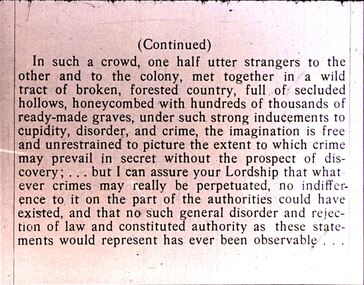
Diggers & Mining. The Digging - The Diggers. Slide: (Continued) In such a crowd, one half utter strangers to the other and to the colony, met together in a wild tract of broken, forested country, full of secluded hollows, honeycombed with hundreds of thousands ready-made graves, under such strong inducements to cupidity, disorder, and crime, the imagination is free and unrestrained to picture the extent to which crime may prevail in secret without the prospect of discovery; . . . But I can assure our Lordship that what ever crimes may really be perpetuated, no indifference to it on the part of the authorities could have existed, and that no such general disorder and rejection of law and order and rejection of law and constituted authorities has ever been observable . . . Markings: 68 994.LIF:6. Used as a teaching aid.hanimounteducation, tertiary, goldfields -
 Surrey Hills Historical Society Collection
Literary work - Book, Messenger Publishing & Consulting Pty Ltd, Camberwell High School 1941-1991, A Jubilee Retrospective, 1991
A history of Camberwell High School from its beginnings in fighting for a school to be built and finally opening for business in 1941. It includes a list of students from 1941-1991. Also a list of female staff and male staff, as well as House Captains, Women's Auxiliary Presidents, Head Prefects, Student Representative Council - Presidents. It also details the School Uniform Policy. It details the growth in the early years, building on the foundations and the modern times, including some troubled years.Height 25 cm, 160 pages, soft cover A soft cover book of 160 pages with black and white photos, newspaper clippings and other illustrations. It includes lists of principals, presidents of school council, house captains, SRC presidents, parents & friends association presidents, women's auxiliary presidents, male and female staff members, and all students who attended the school between 1941 and 1991. There is an extensive list of sources and acknowledgements.non-fictionA history of Camberwell High School from its beginnings in fighting for a school to be built and finally opening for business in 1941. It includes a list of students from 1941-1991. Also a list of female staff and male staff, as well as House Captains, Women's Auxiliary Presidents, Head Prefects, Student Representative Council - Presidents. It also details the School Uniform Policy. It details the growth in the early years, building on the foundations and the modern times, including some troubled years.education and research, secondary schools, school plays, school committees, robert d ewins, camberwell high school, education, camberwell high ex-students society, kylie monogue, elida brereton, robert manne, dannii monogie, brian naylor -
 Ballarat Heritage Services
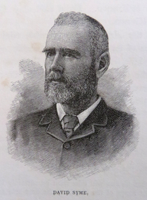
Photograph - Image, David Syme, 1934
David Syme (1827-1908) was a newspaper proprietor who was born on 2 October 1827 at North Berwick, Scotland. Early in 1851, he went via Cape Horn to California seeking gold. By mid-1852 he was in Melbourne, and in the next three years prospected with some success on Ballarat, Bendigo, Castlemaine and Beechworth diggings. In 1855 he lost a possible fortune at Egerton near Ballarat when a promising claim was jumped. Ebenezer Syme bought the insolvent Melbourne Age for £2000, and invited David Syme to take up a share. In September 1856 Syme put up some cash and his contracting business to obtain a half-share. He helped to manage the paper but returned to contracting late in 1857. When Ebenezer retired in 1859 Syme reluctantly returned to the business, and on Ebenezer's death next year he began his fifty-year career as publisher and editor of the Age. (C. E. Sayers, 'Syme, David (1827–1908)', Australian Dictionary of Biography, National Centre of Biography, Australian National University, http://adb.anu.edu.au/biography/syme-david-4679/text7741, published first in hardcopy 1976, accessed online 25 August 2019._Reproducation of a image of David Syme.david syme, portrait, the age, journalist -
 Ballarat Heritage Services
Photograph - Image, David Syme
David Syme (1827-1908) was a newspaper proprietor who was born on 2 October 1827 at North Berwick, Scotland. Early in 1851, he went via Cape Horn to California seeking gold. By mid-1852 he was in Melbourne, and in the next three years prospected with some success on Ballarat, Bendigo, Castlemaine and Beechworth diggings. In 1855 he lost a possible fortune at Egerton near Ballarat when a promising claim was jumped. Ebenezer Syme bought the insolvent Melbourne Age for £2000, and invited David Syme to take up a share. In September 1856 Syme put up some cash and his contracting business to obtain a half-share. He helped to manage the paper but returned to contracting late in 1857. When Ebenezer retired in 1859 Syme reluctantly returned to the business, and on Ebenezer's death next year he began his fifty-year career as publisher and editor of the Age. (C. E. Sayers, 'Syme, David (1827–1908)', Australian Dictionary of Biography, National Centre of Biography, Australian National University, http://adb.anu.edu.au/biography/syme-david-4679/text7741, published first in hardcopy 1976, accessed online 25 August 2019._Reproducation of a image of David Syme.david syme, portrait, the age, journalist -
 Kew Historical Society Inc
Photograph, J F C Farquhar, Bird's Eye View Looking North, 1891
At the beginning of the 1890s, the Kew businessman and Town Councillor, Henry Kellett, commissioned J.F.C. Farquhar to photograph scenes of Kew. These scenes included panoramas as well as pastoral scenes. The resulting set of twelve photographs was assembled in an album, Kew Where We Live, from which customers could select images for purchase.The preamble to the album describes that the photographs used the ‘argentic bromide’ process, now more commonly known as the gelatine silver process. This form of dry plate photography allowed for the negatives to be kept for weeks before processing, hence its value in landscape photography. The resulting images were considered to be finely grained and everlasting. Evidence of the success of Henry Kellett’s venture can be seen today, in that some of the photographs are held in national collections.It is believed that the Kew Historical Society’s copy of the Kellett album is unique and that the photographs in the book were the first copies taken from the original plates. It is the first and most important series of images produced about Kew. The individual images have proved essential in identifying buildings and places of heritage value in the district.This panoramic view was probably taken from the roof of Xavier College. It invites the viewer to look down on the buildings and streets of Kew, and across to the distant horizon. Mansions and solid bourgeois villas dominate the view of Charles and Wellington Streets. The imposing spires of the Presbyterian and Methodist Churches, built in one of the highest areas of Kew, can be seen in the distance. In the foreground, the photographer includes three significant mansions: Molina, Roxeth and Elsinore. Molina, in the foreground, and the group of weatherboard buildings in its yard was used at this stage for the privately operated ‘Kew High School’ (founded 1872). Roxeth, the home of Herbert Henty can be identified by its distinctive four-sided tower. All three buildings are now part of Trinity Grammar. Other built structures observable in the photograph include Wilton (now the Kew RSL), designed by Guyon Purchas for Dr William Walsh in 1886, and the only known image of the Prospect Hill Hotel prior to the renovation of 1935. Bird's Eye View Looking Northkew illustrated, kew where we live, photographic books, henry kellett -
Federation University Historical Collection
Book, George Brown, Prospectors' Guide (Victoria), 1936
... prospecting ...Brown soft covered book with pullout map showing auriferous areas of Victoria. prospecting, gold, geology, quartz reefs, indicators, ballarat indicators, miners' rights, mining leases, forest regulations, equipment, gold cradle, puddling machine, sluice box, whim, whip, california pump, cradle, mining, tools, mining laws -
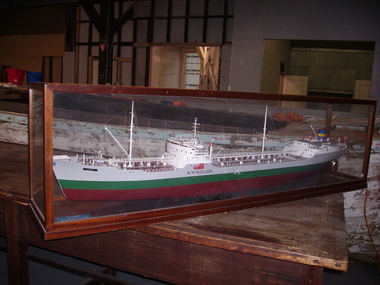 Seaworks Maritime Museum
Shipbuilders model, R W Miller
Original ship - 11,741 gross tons. 589' x 70' x 30' (179.5 x 21.34 x 9.14m). Oil tanker built by Eriksberg Motor Vessels at Gottenburg, Sweden in 1951 for Hjalmar Bjorge of Norway as the Storheim. Purchased November 1964 and renamed R W MILLER. Had a crew of 39 seamen, including the officers. 1973 sold to Independent Shipping Company Pty Ltd of Singapore. Renamed Cherry Victor. Scrapped 1979. Robert Miller traded under the name R W Miller and Company from early 1912. One of Miller's first contracts was to pick up overburden and spoil from the sinking of the Balmain Colliery shaft and dump it at sea. Miller saw the opportunity to sell this material and he ended up getting a sixpence a ton from a local council and other contractors for use as road bases and building foundations. This close association with coal led to Robert W Miller on 15th January 1913 being given the contract for coal distribution from Sydney Harbour Colliery (Balmain mine). So began a long association with coal. Miller built a fleet of lighters that were used to transport blue metal, sand and coal around Sydney Harbour. This introduction into coal transport opened a prospect for him to enter the larger coal shipping transport. During 1917 Miller purchased a vessel, the taking over 1985 by Howard Smith Industries Pty Ltd, Melbourne. Build date 1951-1979. Ship builders model of the tanker R W Miller in a glass case. The body is painted in colours of maroon, green and grey, the deck with detailed fittings and superstructure, an Australian merchant flag flying from the stern, within a mahogany framed glazed display casePlaque at foot of model: M/T R.W. MIILRT/ BUILT GOT. 1951/ OWNERS R.W. MILLER & CO. PTY. LTD/ LENGTH OVERALL 559.04"/ LENGTH BETWEEN P.P 526.06"/ EXTREME BREADTH 70.00"/ MOULDED DEPTH 39.03"/ DEADWEIGHT TONNAGE 18,500/ MACHINERY B & W TYPE A I.H.P 7, 600" on model: "R.W Miller" painted in black -
Tarnagulla History Archive
Box of Donald Clark's Research Notes, Donald Clark's Research Notes, circa 1960s-2000s
Donald Clark Collection. Blue-grey archive box containing research notes of Donald Clark. Within this set are multiple archival folders with the following subject matter: Hotels Gold, prospecting & mining Peace Picnic Street lighting Churches Cemetery Poems Shire of Bet Bet Chinese Clubs Police Transport Local businesses/premises Local people Post Offices Previous history work / previous history enquiries Back To Tarnagulla events Victoria Theatre / Entertainment Schools Water and waterways Early town Mapping and geography Photocopies of photos Miscellaneous Rail Link Centenary Newbridge Eddington Waanyarra Bet bet (town) Llanelly Murphy's Creek / Irishtown Laanecoorie Military Service Fire Brigade Tarnagulla Landmarks / Places of Interest Family Histories Births, Deaths, Marriage info Transcript of St. Saviour's Records A plastic pocket containing duplicate copies of local history images held elsewhere in the collection. The contents of these files were research notes compiled by Donald Clark from his local history research about Tarnagulla and district. tarnagulla & district, donald clark, research -
 Federation University Historical Collection
Photograph, R. Millist, Hanlon Consols Mine Rokewood, 1901
The photo depicts one shift of mine hands at Hanlon Consols Mine Rokewod in 1901. ist on the left is George Edgar Yung. George was born in Ararat the son of Yohann Godlip and Christina (b Weller)Yung. They lived at Happy Valley near Linton. and Piggoreet. Yohann was a miner and died in the All Nations Mine collapse at Derwnt Jack's in 1877. Interesting to note in the following information that the Hanlon Consol mamager, William Maughan was also the manager of the Try Again Mine in Piggoreet. He was also on the six man school committee of Piggoreet Common School No. 726. (Is this why George Yung ended up working in Rokewood because of a previous connection at Piggoreet? George married Clara Emma Smith from Happy Valley and worked in a mine at Allendale. They later moved to Yendon) About the Hanlon gold mining company near Rokewood. 1901 - Information Bendigo Prospecting Club, 21/08/2020. Information provided once again by Peter McCarthy. Christopher Hanlon had put down a line of bores south of the Rokewood main street, looking for a continuation of the Break O’Day lead which had been worked for two or three miles with highly payable results, though in a primitive manner. Ground was being paddocked 30 feet deep and made to pay. The bores suggested the sinking would be about 70 feet and a shaft site was selected at the back of Stanbrook’s Hotel. The Hanlon Gold Mining Company was formed in March 1895 and the shaft was bottomed at 68 feet, getting just over an ounce of gold from the shaft bottom. By January 1896, the poppet heads were up, and steam plant was nearly ready. The mine produced 846 oz by September, which was not as good as expected, but they installed a second puddling machine. The mine was profitable for the next three years, with periods of prospecting and the need to install steam pumps in 1897. A second shaft was sunk in 1899, which bottomed at 86 feet on good wash and was sunk on to 109 feet. 1743 oz of gold had been produced in six months to September 1899, but the No1 shaft was let on tribute as the No2 workings were opened and machinery installed the following year. The No1 shaft tributors broke even in 1900 and in 1901 the shaft was shut down, with the No1 shaft machinery sold late in 1902. By September 1901, the mine had produced gold worth £66,124 and the No2 shaft main drive was in 346 feet, with gold being found mainly in crevices in the hard floor. Mining continued, but once the No2 shaft workings met up with the old No1 shaft workings at the end of 1902 there was not much wash remaining. The mine was let on tribute in June 1903 and a drive was put in to test deeper ground. The company was wound up in February 1904 and the plant sold. From what they discovered, the manager concluded that the mine sat at the edge of an ancient coastline and the gold was in a beach deposit. The total gold production from the mine was worth £73,294. J Lee Archer JP, shareholder, was the manager of the Bank of Victoria in Ballarat. Born in Tasmania, he came to Victoria with his parents and first came to Ballarat in 1855 as a junior clerk with the bank. He died in 1902 aged 64. Alexander J. Peacock was a legal manager and a share broker. In 1897 Peacock, born in Creswick, had been elected as one of the Victorian delegates to the Constitutional Convention which wrote the Australian Constitution. He later became a politician, state treasurer and three times state premier of Victoria and was knighted KCGM. He died in 1933 aged 72. William Maughan, director, was an English miner who came to Victoria in the 1850s and became a mine manager, managing the Try Again at Piggoreet, Ryan’s Freehold and the Madam Berry, among others. He died in Williamstown in 1915 aged 85. Sepia photographRhs front of photo: R. Millist Phto & Lanternist Geelong Verso (upside down): ONE SHIFT OF MINE HANDS HANLON CONSOLS MINE ROKEWOOD 1901 Grandfather Yung 1st on left rokewood, hanlon consols mine, shift of mine workers 1901, gold mines, george edgar godlip yung, william maughan