Showing 463 items matching " route 5"
-
 Ballarat Tramway Museum
Slide - 35mm slide/s - set of 32, Noel Simons, 25/02/1971 12:00:00 AM
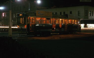
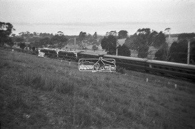
... surrounds 1201.17 - No. 5 en route for Quarry Hill crossing No. 26... photo showing surrounds 1201.17 - No. 5 en route for Quarry ...Set of 31 transparencies taken on 25/2/1972 on Kodak mounts. 1201.1 - Bendigo No. 26 in Bond St. just after leaving Long Gully en route for Quarry Hill. Has Norris Supermarket in background. Has two SEC roof ads. 1201.2 - No. 26 climbing View St. from Charing Cross en route to Eaglehawk. Has ANZ bank and AMOCO service station in background. 1201.3 - as for 1201.3, but after tram has passed photographer. Has buildings west of Mackenzie St. in photograph. 1201.4 - Tram stop and centre of the road pole with two "CARS STOP BY REQUEST" signs mounted on pole at the corner of Mackenzie St. 1201.5 - same position as for 1201.3, but with No. 5 descending the street. 1201.6 - same position as for 1201.2, but with No. 5 descending the street. Photo taken after tram has passed photographer. 1201.7 - No. 7 in Nolan St. from across the park at Lake Weeroona. 1201.8 - No. 7 entering McCrae St from Nolan St. - distant view. Note "TRAM "sign on left hand side under tree and overhead in McCrae St. from former track that once was in this street. 1201.9 - No. 7 in High St. with Cathedral in background. Tram en route to North Bendigo. Note scaffolding around Cathedral main spire area. 1201.10 - No. 7 crossing Bendigo Creek bridge in High St. near Golden Square. Has a Caltex Service station in the background. 1201.11 - No. 7 at Golden Square terminus with Sunburst Fruit Juices and a Peters Ice cream delivery vans alongside. 1201.12 - as for 1201.11 but photo taken from behind tram, with the end of the rails in the photograph. 1201.13 - No. 7 and 21 in Pall Mall at Charing Cross with No. 5 in the background. Taken some distance away from the location. 1201.14 - No. 7 at Golden Square terminus, taken a short distance from the tram terminus. Shows Milk Bar on right hand side and the hotel on the left hand side. Taken from the south side of the roadway. 1201.15 - as from 1201.14 but taken from the north side of the roadway. 1201.16 - No 5 waiting at California Gully loop. Distant photo showing surrounds 1201.17 - No. 5 en route for Quarry Hill crossing No. 26 at California Gully. 1201.18 - No. 26 at Eaglehawk terminus with Eaglehawk Town Hall and Post Office in background. 1201.19 - No. 21 arriving at Charing Cross en route to North Bendigo. Has Alexandra Fountain in the background, ANZ bank RACV building, and other buildings on the north side of Pall Mall or Nolan St. 1201.20 - No. 26 en route for Quarry Hill at Charing Cross, with crew standing by front door. Has Colonial Mutual life building, Armstrong Tyre Service (Firestone) and a sign for Cohns Drinks in the background. 1201.21 - as for 1201.20 but with No. 5 en route to Eaglehawk now in photograph. 1201.22 - No. 26 at Quarry Hill terminus. 1201.23 - No. 26 at Quarry Hill terminus, view of front portion of tram only from a gate at the Bendigo cemetery. 1201.24 - Track at the end of the Quarry Hill line showing the point blades of the former "Y" terminus and the overhead for this. 1201.25 - No. 2 at the Quarry Hill terminus, looking along the former Trackwork. 1201.26 - as for 1201.25 1201.27 - number not used. 1201.28 - Golden Square terminus from some distance from the actual terminus, showing the Warning sign "TRAM" for motorists from the south. No. 7 at the terminus. 1201.29 - No. 7 passing through the Golden Square shopping centre. Numerous cars and pedestrians. Tram en route for North Bendigo. 1201.30 - No. 7 in High St. Golden Square, en route for North Bendigo. Photo taken after tram has passed photographer. 1201.31 - No. 7 in High St. just past Wattle St. with the Cathedral in the background. Tram has two SEC roof ads good side on photo, 'Everything's fine in my all electric kitchen' and 'Electrical cooking - clean, quick, economical'. 1201.32 - No. 7 in High St. nearing Wattle St. Has Cathedral in the background. Photo taken after tram has passed photographer.Information written on in black ink and date stamped on purple ink. 1201.1 - "No. 26 in Bond St just after leaving Long Gully" 1201.2 - "No. 26 climbing View St. from Charing Cross" 1201.3 - "No. 26 ascending View St. from Charing Cross (At Mackenzie St.)" 1201.4 - "View St. & Mackenzie St." 1201.5 - "No. 5 in View St. near Mackenzie St." 1201.6 - "No. 5 in View St. nearing Charing Cross." 1201.7 - "No. 7 in Nolan St. seen from Lake Weeroona Park." 1201.8 - "No. 7 entering McRae St. from Nolan St. Note "TRAM" warning sign on left. 1201.9 - "No. 7 in High St. passing Short St." 1201.10 - "No. 7 crossing Bendigo Creek bridge in High St. near Golden Square." 1201.11 - "No. 7 at Golden Square terminus" 1201.12 - "No. 7 at Golden Square terminus" 1201.13 - "No 7, 21 and 5 at Charing Cross" 1201.14 - "No. 7 at Golden Square terminus" 1201.15 - "No. 7 at Golden Square terminus" 1201.16 - "No 5 waiting at California Gully loop." 1201.17 - "Nos. 5 and 26 crossing at California Gully loop" 1201.18 - "No. 26 at Eaglehawk terminus" 1201.19 - "No. 21 arriving at Charing Cross from Golden Square" 1201.20 - "No. 26 at Charing Cross" 1201.21 - "Nos. 5 and 26 at Charing Cross." 1201.22 - "No. 26 at Quarry Hill terminus" 1201.23 - "No. 26 at Quarry Hill terminus seen through the gates of the Bendigo Cemetery." 1201.24 - "Quarry Hill terminus showing remains for former double track layout abandoned before 1964." 1201.25 - "No. 2 at Quarry Hill terminus" 1201.26 - "No. 2 at Quarry Hill terminus" 1201.28 - "The Southern approach to Golden Square with No. 7 standing at the terminus, "TRAM" warning sign on the left. 1201.29 - "No. 7 passing through Golden Square Shopping Centre" 1201.30 - "No. 7 in High St. Golden Square" 1201.31 - "No. 7 in High St. passing Wattle St." 1201.32 - "No. 7 in High St. nearing Wattle St."tramways, trams, bendigo, bond st., view st., nolan st., high st., eaglehawk, california gully, charing cross, quarry hill, trackwork, tram 2, tram 5, tram 7, tram 21, tram 26 -
 Melbourne Tram Museum
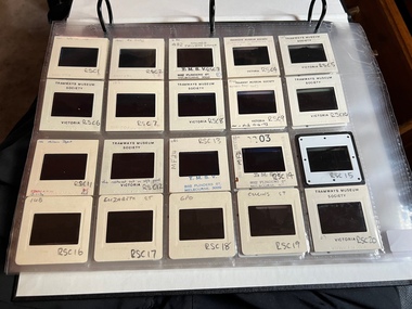
Album - Ron Scholten Slide Collection, Ron Scholten
... in Matthews Ave RSC82 W2 383 on route 5 turning from the reserved... in Matthews Ave RSC82 W2 383 on route 5 turning from the reserved ...Photo - see pdf file for further information. Number Brief Description RSC1 PCC 1041 at the gates of Preston Workshops on a test run without it’s trolley retriever RSC2 PCC 1041 in Glenhuntly Road on Route 67 en route to Carnegie crossing the Railway Gates at Glenhuntly Station RSC3 W2 482 stored at Malvern Depot with Olympic Park on the Destination RSC4 Cable Car Set 64 in Swanston St outside Princess Bridge Station in Bound with open top Double Deck Bus, Trak Motors ? Departing from Flinders St Station RSC5 W3 669 in St George Rd at Sumner St en route to Preston Workshops for scrapping RSC6 Cable Car in Lygon St en route to Carlton RSC7 PCC 1041 turning from St Georges Rd into Miller St to enter Preston Workshops RSC8 Flinders St Station with cable cars RSC9 PCC 1041 in strife on it’s maiden day in service. Trams on route 88 delayed in Queens Parade Clifton Hill RSC10 Flinders St at William St with Cable Cars RSC11 L 104 on the fan of the new shed at Malvern Depot on a TMSV tour RSC12 Cable Set 1 after it’s restoration at Preston Workshops on the fan near the front gate RSC13 X1 466 at a suburban terminus of the Footscray System RSC14 X2 680 at Point Ormond Terminus RSC15 An ex Launceston Tram at the outside terminus of the Penny Royal Complex Tramway in Launceston RSC16 Q 148 at Preston Workshops awaiting disposal RSC17 Elizabeth St with Cable Cars RSC18 Elizabeth and Bourke St corner outside the GPO with cable cars RSC19 Collins St with Cable Cars RSC20 A photo taken from the observation deck of the ICI building showing a view of Parliament house with a w class tram in Nicholson St RSC21 Auburn Horse car with a posed photo of all the tramwaymen employed RSC22 Cheltenham Double Deck Horsecar with a full load of passengers RSC23 City of Northcote cable trailer 3 at a terminus RSC24 City of Northcote Cable cars passing in High St Northcote RSC25 St Kilda Rd at Princes Bridge with Cable Cars RSC26 Flinders St with Cable Cars RSC27 Cable Cars RSC28 Bourke St looking towards Elizabeth St from Queen St RSC29 Cable cars in Bourke St at Elizabeth St looking East RSC30 Cable cars in Elizabeth St at the terminus at Flinders St RSC31 Cable cars in Bourke St at Swanston St looking west RSC32 Cable cars in Swanston St at Flinders St looking North RSC33 Cable cars in Collins St near Russell St RSC34 Cable cars in Elizabeth St at Bourke St RSC35 Cable cars in Collins St at Elizabeth St RSC36 Cable Cars in Swanston St at Flinders St RSC37 Cable cars in Collins St RSC38 Cable Cars RSC39 Cable cars in St Kilda Rd near Princes Bridge RSC40 Cable cars in Collins St East of Swanston St RSC41 Cable cars in Spring St outside Parliament house RSC42 K 92 in M&MTB Chocolate and cream livery but with a P&MTT Destination box on Route 14 RSC43 Thornbury depot viewed from Miller St and St Georges rd. Two W2 class cars are laying over between the peaks RSC44 Z3 201 in Met Livery passes D1 3510 in new M Tram livery. A Staff member in uniform stands in the doorway. Dandenong Rd RSC45 D1 3530 advertising Heinekin Super Golf on Route 55 in Royal Park RSC46 D1 3504 in M Tram livery on the reserved track in Matthews Ave near Essendon Airport showing Route 81 Travancore . I suspect it is a private enthusiasts charter due to the Malvern W class run number in the rear windscreen RSC47 D1 3504 on Route 64 in Dandenong Rd in M Tram Livery RSC48 D1 3504 in M Tram Livery at Airport West Terminus RSC49 D1 3504 in M Tram Livery in Union Rd outside the Showgrounds RSC50 D1 3504 at West Maribyrnong Terminus in M Tram Livery RSC51 D1 3503 in M Tram Livery in Malvern Depot RSC52 SW6 960 and VR 53 in Harbour Esplanade for the NMEL&T Co Centenary RSC53 Hawthorn Tramways Trust 32 in Harbour Esplanade for the NMEL&T Co Centenary RSC54 VR 53 & B 2042 in Harbour Esplanade for the NMEL&T Co Centenary RSC55 VR 53 & C 3016 in Harbour Esplanade for the NMEL&T Co Centenary RSC56 NMEL&T Co 13 usually V214 in Harbour Esplanade for the NMEL&T Co Centenary RSC57 NMEL&T Co 13 usually V214 at Preston Workshops for the NMEL&T Co Centenary RSC58 Hawthorn Tramways Trust Lettering on HTT 32 in Harbour Esplanade for the NMEL&T Co Centenary RSC59 Hawthorn Tramways Trust 32 in Harbour Esplanade for the NMEL&T Co Centenary RSC60 Hawthorn Tramways Trust 32in Harbour Esplanade for the NMEL&T Co Centenary RSC61 Hawthorn Tramways Trust 32 in Harbour Esplanade for the NMEL&T Co Centenary RSC62 NMEL&T Co 13 usually V214 at Preston Workshops for the NMEL&T Co Centenary RSC63 W2 516 and another on route 59 wait to shunt at Essendon Airdrome Terminus as W2 571 on route 49 departs. This was the last day of operation. RSC64 Australia’s First Electric Tram at Box Hill with Tramwaymen including H J Hilton who is in the centre RSC65 W2 484 en route to St Kilda Junction and another wait for passengers after a race meeting at Caulfield Racecourse RSC66 X1 463 on the Footscray system en route to Russell St RSC67 Geelong 35 on Chilwell Route, Formerly HTT 13, M&MTB 119, then Bendigo 1 and Ballarat 37 RSC68 P&MTT 4 on Opening Day of the system in Glenferrie Rd RSC69 Bendigo 6 in McCrae St near the Depot end route to North Bendigo RSC70 P&MTT 4 in Glenferrie on opening day of the System RSC71 Scrubber 3 stripped and awaiting scrapping at Preston Workshops RSC72 Scrubber 4 at South Melbourne Depot RSC73 Q 191 & 139 at Preston Workshops awaiting scrapping RSC74 Rail Grinder 3 at Preston Workshops as purchased from Sydney RSC75 Y 469 waits to shunt at Wattle Park Terminus as Y1 613 departs on driver training duties RSC76 VR 53 on the outside roads at Essendon Depot RSC77 W5 796 with three doors and square windows running out of Brunswick Depot in Cameron St, with a supplementary destination board showing “City via Swanston St” RSC78 W2 258 on the wheel grinder road at Brunswick depot RSC79 X2 676 on a TMSV tour, W5 817 & 836 & VR 53 on the open roads at Essendon Depot RSC80 PCC 1041 on test, passes W71035 in High St Preston RSC81 D1 class production number 7 as delivered on test in Matthews Ave RSC82 W2 383 on route 5 turning from the reserved track in Dandenong Rd into St Kilda Rd at St Kilda Junction RSC83 Z3 204 as advertising tram for Vodaphone Grand Prix running into Malvern Depot new shed RSC84 Z1 4 on test in St Georges Rd RSC85 PCC 1041 on Route 96 in Burke St near Exhibition St RSC86 Z1 3 without numbers on test turning from Miller St in St Georges Rd RSC87 Track components stored in Coldblo Rd at Malvern Depot with Z class cars adjacent RSC88 D1 3501 in M Tram Livery on Route 55 in Peel St at Franklin St RSC89 C 3001 in Yarra Trams Livery Porto 018 & D13502 in M Tram Livery on Display in Harbourside Esplanade RSC90 D1 class tram production number 7, in as delivered condition on test in Matthews Ave RSC91 D1 3503 inside Malvern Depot RSC92 SW6 955 and W6 974 in St Kilda at City Rd at Dusk RSC93 Freight Car 19 at Preston Workshops in green Livery RSC94 Rail Grinder 3 in green Livery at South Melb Per Way Yard RSC95 A SW6 class car on route 50 shunting at Elizabeth St Terminus at night, taken from Flinders St Station RSC96 W2 588 & 435 in St Kilda Rd at Batman Ave RSC97 Y1 613 in service at Wattle Park Terminus RSC98 W2 588 in Wellington Parade en-route to the City with a Grand Final Load of passengers followed closely by 384 RSC99 W2 558 on a MCG Footy Special entering the Simpson St sidings RSC100 W3 657 & an L Class in the new shed at Malvern Depot RSC101 Y1 613 in St Kilda Rd on an enthusiasts tour in St Kilda Rd south of St Kilda jun RSC102 Y1 613 on an enthusiasts tour in Clarendon St with the two extra tracks on the Viaduct under construction RSC103 W6 976 on the fan of the new shed at Malvern Depot RSC104 W7 1024 as an advertising car for Bank of NSW at the route 1 terminus at South Melb Beach RSC105 PCC 980 on route 96 in Nicholson St near North Fitzroy Depot RSC106 SW6 890 with dash canopy lighting in Market St on the opening day of William St Services RSC107 W2 444 with big numbers heads a line of footy specials in Simpson St Sidings RSC108 Cable Cars in Elizabeth St RSC109 NMEL&T co 2 with a trailer outside the power station in Mount Alexander Rd RSC110 Alf Twentyman’s cable car set in his Northcote backyard RSC111 Cable Cars in Queens Parade Clifton Hill RSC112 Cable cars in Collins St outside the Townhall RSC113 PCC 1041 at Carnegie terminus RSC114 Cable cars in Elizabeth St RSC115 Cable cars in Collins St near Swanston St RSC116 HTT 19 turns from Riversdale Rd into Camberwell Rd at Camberwell Junction RSC117 W1 419 official builders photo of first car of the class RSC118 Cable car with a full load of passengers RSC119 W1 422 illuminated for the visit of T.R.H. The Duke and Duchess of York RSC120 PCC 1041 in strife on it’s maiden day in service. Trams on route 88 delayed in Queens Parade Clifton Hill RSC121 Bendigo birney in Finn St near North Bendigo terminus RSC122 SW6 in St Kilda Rd at Domain Rd at night RSC123 All 3 of Alf Twentyman’s cable cars in his Northcote backyard RSC124 Cable trailer 256 being unloaded into the shed at Bylands RSC125 Cable grip car 1 being removed from the Melbourne Museum RSC126 Alf Twentyman's cable cars in his Northcote Backyard RSC127 Alf Twentyman's cable cars in his Northcote Backyard RSC128 Alf Twentyman's cable cars in his Northcote Backyard RSC129 Alf Twentyman's cable cars in his Northcote Backyard RSC130 W class car in Swanston St at Collins St RSC131 Y1 469, L & W3 on the run out of Glenhuntly Depot on a tour RSC132 W7 1024 as an advertising tram for Bank of NSW at Clifton Hill RSC133 W2 496 on a footy special in Simpson St Sidings RSC134 W2 as originally converted to a test car at Preston Workshops RSC135 W3 667 in Brunswick Depot with Ellen Butland at the controls RSC136 W3 669 on it’s final run at Victoria Prd & Brunswick St RSC137 W2 571 in Wellington Prd at Clarendon St with a Footy Final load of Passengers RSC138 Y1 613 shunts at Spencer St Terminus as X217 waits on Australia Day Pageant RSC139 PCC 1041 on Rt 96 in Burke St outside the Southern Cross Hotel RSC140 890 with accident damage on the outside roads at Preston Workshops c1978 RSC141 535 on Rt 4 at the old St Kilda Jun c1967 RSC142 1041 on Rt 88 turns from Bourke St into Spring St 1973 RSC143 102 on a tour at Albert Park Beach Terminus Feb 1972 RSC144 833, 835 & 834 in the shed at Malvern Depot c1976 RSC145 281 in Wellington Parade on a football very crowded special c1974 RSC146 464 Ballarat Rd 1960 RSC147 181 Explosives Fty - at Footscray Station - July 1960 RSC148 181 Williamstown Road 1960 RSC149 Cable car set at Alf Twentyman’s c1970 RSC150 X 217 at Malvern Depot c1970 RSC151 X1 465 and T181 Footscray Football ground in Barkly St. c1960 RSC152 Scrubber 5 at South Melbourne depot c1960 RSC153 X1 465 Footscray to Russell St, c1960 RSC154 X1 467 Leeds St Footscray 1960 RSC155 PMTT 4 Glenferrie Road, 1910 RSC156 S 164 at Malvern Depot c1970 RSC157 T178 Footscray c1960 RSC158 Cleaner No. 7 at South Melbourne depot c1960 RSC159 Two Y classes at Princes Bridge / Batman Ave mid 1950s RSC160 Swanston St – Nu color vue slide – M142 Demonstrates the work of Ron Scholten in photography, collection and/or production of duplicate slidesAssembled album in a black presentation folder of 160 colour slides, 8 slide sleeves, collected or produced by Ron Scholten. Many are TMSV or Windsor Publications slides. All photographs have been scanned and placed on the Museum's G drive. A list of all photographs with details has been compiled. melbourne, tramways, trams, cable trams -
 Ballarat Tramway Museum
Slide - 35mm slide/s - set of 23, Noel Simons, 26/02/1972 12:00:00 AM
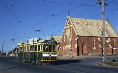
... in the background. 1205.16 - No. 5 en route for Quarry Hill at Charing... in the background. 1205.16 - No. 5 en route for Quarry Hill at Charing ...Set of 23 transparencies taken on 26/2/1972 on Kodak mounts. 1205.1 - Bendigo No. 25 on a special tour at Fire Station Loop, en route to Golden Square. 1205.2 - No. 21 and 25 crossing at Fire Station Loop, note photographers on the ground. No. 21 bound for North Bendigo. 1205.3 - as for 1205.3, but with trams departing loop and fire station in the background. 1205.4 - No. 25 at Golden Square Hotel with 'Rodda's Golden Square Hotel' in the background. Tram on a special tour, but showing destination of North Bendigo. 1205.5 - as for 1205.4 - but showing special. Has the end of the track in the photograph. 1205.6 - Nos. 7 and 25 (on a special tour) crossing at Myrtle St. Loop. 1205.7 - No. 7 leaving Myrtle St. loop with the mine poppet head in the background. Photo taken after tram has passed photographer. (Print made of this slide 10/2001 for use in the Gold Gold Gold exhibition of 10/2001 - See Reg. item 1979. 1205.8 - No. 25 entering depot. Tram showing 'special'. Tennis court on right has players. Photo taken after tram has passed photographer. 1205.9 - No. 24 (showing 'special') and No. 20 (showing 'Long Gully') at Bendigo Depot. 1205.10 - No. 24 on a special charter, leaving Bendigo depot. Tram has two 'Johnnie Walker' roof ads. 1205.11 - Bendigo depot with 29, 25 and a bogie car inside the depot doors. 1205.12 - As for 1205.11, but with 28 and 29. 1205.13 - No. 24 standing at front entrance of Bendigo depot with No. 20 in the background. 1205.14 - No. 24 running out into McCrae St showing special, with conductor on front step. 1205.15 - No. 24 in Caledonia St. at corner of Thunder St with the Gasworks in the background. 1205.16 - No. 5 en route for Quarry Hill at Charing cross with No. 26 (en route for Eaglehawk) about to arrive. Has former crossover at this location in the foreground. Has the Ezywalkin building in the background. 1205.17 - No. 5 and 26 at Charing Cross, with the Alexandra Fountain in the foreground and the Beehive and Ezywalkin buildings in the background. No.26 has two SEC roof ads. 1205.18 - Charing Cross looking along Pall Mall with trams 7 and 21 and 26 in the picture. 1205.19 - Charing Cross, with 21 departing for Golden Square and No. 5 heading for Quarry Hill. Has the Ezywalkin and the Beehive buildings in the background. 1205.20 - as for 1205.19, but a few moments later. Adjacent pole has a "NO ROAD" letter in reflectors vertically. 1205.21 - Charing Cross with Nos. 25, 21, 26 and 7, looking south from Pall Mall end. 1205.22 - No. 24 crossing Mitchell St. en route for Golden Square, showing 'special' with the Beehive and Ezywalkin buildings in the background. 1205.23 - Charing Cross with Nos. 24, 21 and 7 in the photo and Fountain Plaza in the background. Print of 1205.7 - stored in box D1.Information written on in blue ink and date stamped on purple ink. 1205.1 - "No. 25 at Fire Station Loop High Street, Golden Square." 1205.2 - "Nos. 25 and 21 crossing at Fire Station Loop, near Golden Square." 1205.3 - "Nos. 25 and 21 crossing at Fire Station Loop, near Golden Square." 1205.4 - "No. 25 at Golden Square terminus." 1205.5 - "No. 25 at Golden Square terminus." 1205.6 - "Nos. 7 and 25 crossing at Myrtle St. Loop." 1205.7 - "No. 7 leaving Myrtle St. Loop." 1205.8 - "No 25, entering Bendigo Depot." 1205.9 - "Nos. 20 and 24 at Bendigo Depot." 1205.10 - "No. 24 at Bendigo Depot." 1205.11 - "Nos. 25 and 29 at Bendigo Depot." 1205.12 - "Birney cars 29 and 28 at Bendigo Depot." 1205.13 - "No. 24 (with 20 beyond) at Bendigo Depot." 1205.14 - "No. 24 entering McCrae St. from Arnold St." 1204.15 - "No. 24 in Caledonia St. at cnr of Thunder St." 1204.16 - "No. 5 waits at Charing Cross as No. 26 arrives from Quarry Hill. Note remains of crossover abandoned on relocation in 1965." 1204.17 - "Nos. 5 and 26 at Charing Cross." 1204.18 - "Nos. 26, 7 and 21 at Charing Cross (No. 5 just visible behind No. 26)." 1204.19 - "No. 21 leaves Charing Cross for Golden Square as No. 5 starts off for Quarry Hill." 1204.20 - "No. 21 swings onto the single track Golden Square line as No. 5 heads into Mitchell St. towards Quarry Hill." 1204.21 - "Nos. 25, 21 and 26 watch No. 7 arrive at Charing Cross from Golden Square." 1204.22 - "No. 24 at Charing Cross crossing Mitchell St." 1204.23 - "Nos. 24, 21 and 7 at Charing Cross."tramways, trams, bendigo, golden square, myrtle st., fire station, depot, charing cross, tram 5, tram 7, tram 20, tram 21, tram 24, tram 25, tram 28, tram 29 -
 Ballarat Tramway Museum
Slide - 35mm slide/s - set of 20, Noel Simons, 21/05/1971 12:00:00 AM
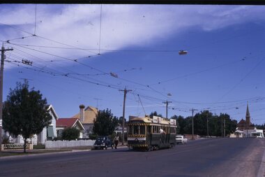
... . 1197.1 - Bendigo No. 5 en route to Eaglehawk at Creeth St Long... No. 5 en route to Eaglehawk at Creeth St Long Gully. Tram has ...Set of 20 transparencies taken on 21/5/1971 on Kodak mounts. 1197.1 - Bendigo No. 5 en route to Eaglehawk at Creeth St Long Gully. Tram has a SEC roof ad and Cinzano roof ad. 1197.2 - No 5 approaching Needle Loop between Long Gully and California Gully. On left hand side is the City of Bendigo sign, indicating city boundary. 1197.3 - As for 1197.2 but actually entering loop. Photo taken after tram has passed photographer. 1197.4 - No. 26 bound for Eaglehawk descending the railway bridge near Eaglehawk, at Jobs Gully. 1197.5 - as for 1197.4, but after crossing bridge, now ascending a hill. Photo taken after tram has passed photographer. 1197.6 - No. 26 climbing High St. hill Eaglehawk, nearing end of Double track, bound for Quarry Hill. Shows centre of the road poles. 1197.7 - As for 1197.6, with tram entering single track section. Photo taken after tram has passed photographer. Has a BP service station in the background. 1197.8 - No. 26 (bound for Quarry Hill) crossing No. 17 (Eaglehawk) at Job's Gully Loop. 1197.9 - No. 17 climbing railway bridge at Job's Gully, en route to Eaglehawk. Photo taken after tram has passed photographer. 1197.10 - No.26 bound for Quarry Hill, leaving Long Gully Loop? Has the Creeth St. church in l197.l in the far background. Photo taken after tram has passed photographer. 1197.11 - Tramway Point work at the northern end of Long Gully Loop. 1197.12 - No. 17 en route for Quarry Hill turning into View St. from Bamard St. Tram has SEC roof ads "Everything fine in my all electric Kitchen' and 'Electric Cooking is Matchless'. 1197.13 - as for 1197.12, but tram has turned into View St and about to enter the double line track. Photo taken after tram has passed photographer. 1197.14 - No. 21 enters Nolan St after turning from MacRae St. en route to Bendigo. Note sign on its own post noting tram turns "Beware Tram Turns" and stop sign on adjacent pole "Trams stop on Request". No. 21 has two SEC roof ads. 1197.15 - No. 21 in Nolan St. after turning from Bridge St. (White Hills Road). Note signal light for Bridge St. loop on pole corner of street. Photo taken after tram has passed photographer. 1197.16 - No. 2 bound for Eaglehawk at unknown location. 1197.17 - Tram stop sign on a pole "CARS STOP BY REQUEST" 1197.18 - No. 5 in Carpenter St.? en route to Quarry Hill. 1197.19 - No. 28 has just arrive at Golden Square terminus, passengers are disembarking and the trolley pole is being turned. Golden Square Hotel in the background. 1197.20 - No. 28 at Golden Square terminus. Has a "Nothing beats Briquettes for hear roof ad. Information written on in black ink and date stamped on purple ink. 1197.1 - "No. 5 at Creeth St. Long Gully" 1197.2 - "No. 5 approaching Needle Loop between Long Gully and California Gully" 1197.3 - "No. 5 at Needle Loop between Long Gully and California Gully" 1197.4 - "No. 26 crossing railway bridge at Job's Gully near Eaglehawk" 1197.5 - "No. 26 just after crossing railway bridge at Job's Gully near Eaglehawk/ 1197.6 - "No. 26 in High St. Eaglehawk" 1197.7 - "No. 26 at end of double track in High St. Eaglehawk" 1197.8 - "Nos. 26 and 17 crossing at Job's Gully Loop" 1197.9 - "No. 17 crossing railway bridge at Job's Gully near Eaglehawk". 1197.10 - "No. 26 at Long Gully" 1197.11 - 'Northern end of points at Long Gully Loop". 1197.12 - "No. 17 turning into View St. from Bamard St. Bendigo". 1197.13 -'No. 17 at beginning of double track in View St. after leaving Bamard St. Bendigo. 1197.14 - "No. 21 enters Nolan St. from MacRae St. Bendigo." 1197.15 - "No. 21 in Nolan St. Bendigo just after leaving White Hills Road." 1197.16 - "No. 2" 1197.18 - "No. 5" 1197.19 - "Birney car No. 28 at Golden Square Terminus" 1197.20 "Birney car No. 28 at Golden Square Terminus" tramways, trams, bendigo, long gully, railway bridge, jobs gully, trackwork, nolan st, quarry hill, tram stops, golden square, tram 2, tram 5, tram 17, tram 21, tram 26, tram 28 -
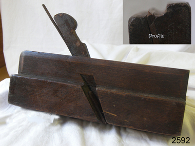 Flagstaff Hill Maritime Museum and Village
Tool - Moulding Plane, Charles Nurse, 1860-1900
The original Nurse family business began in 1841 in Maidstone Kent until 1861 where they were plane makers, moving to London in 1887 the company became C Nurse & Co. And continued until 1937 under that name at the (Invicta works). The majority of their plane making was done in London but there are Sheffield and Brighton marks on their tools as well. The company was not only wood plane makers but tool makers in general with the Charles Nurse & Co catalogue having 350 pages of tools for sale of varying types for different building trades and over 138 pages dedicated to woodworking tools. Records show that the company was at 182 Walworth Road London from 1887-1949. However, they had several retail outlets before this time and records indicate before 1887 Charles Nurse was at 32 Mill St Maidstone Kent, from 1844 -1860 but were in business before then. Also in Brighton at 135 Queens Road from 1865 -1871 and at 3 Mill Street Maidstone, again from 1872 - 1889 listed on records of the time as “plane and tool makers.”A vintage item made by a significant tool maker and retailer from the middle of the nineteenth century and into the first half of the twentieth century. These items were made commercially for firms and individuals that worked in wood and needed a tool that could produce an ornamental finish to timber. The tool was used before electric or mechanical routers or spindle moulders came into use. They were used by craftsmen to produce decorative mouldings by hand. These profiled planes came in various shapes and sizes. A significant tool that today is quite rare and sought after by collectors. It gives us a snapshot of how furniture and other decorative finishes were created on timber by the use of hand tools only. Moulding plane Side Bead - Single Box Size 5/16 Maker Charles and Co 1863 Stamped W. Burden (previous owner)flagstaff hill, warrnambool, shipwrecked-coast, flagstaff-hill, flagstaff-hill-maritime-museum, maritime-museum, shipwreck-coast, flagstaff-hill-maritime-village -
 Bendigo Military Museum
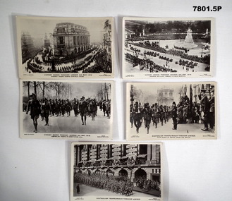
Postcard - POSTCARD - LONDON 1919, J Beagles & Co Ltd, c1919
Series of postcards, featuring Australian Troops who participated in the Victory Parade through London after WW1 on 3rd May, 1919.1. Troops marching past Australia House in London. Spectators lining the route. 2. Column of mounted troops and horse drawn artillery. Large monument in right background. Spectators lining the route. 3. Troops in uniform with arms shouldered marching along road. Spectators lining the route. 4. Troops in uniform with arms shouldered, marching along the road. Man in uniform on right is taking the salute. Uniformed police officer on right. 5. Troops in uniform with arms shouldered marching along road. Man in uniform on bottom right hand side taking the salute. Battle honours of troops attached to building in background. robert h. baron, cooper collection, postcard, london, ww1, victory parade, australian troops -
 Bendigo Military Museum
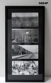
Photograph - PHOTOGRAPHS, GRINTON COLLECTION, FRAMED, 2008 - 2009
Frame 5. Photo 1. Lonely graves on a battlefield. This has been identified as "Vaire Wood cemetery" just south of the Somme at Vaire-sous-Corbie. Some 28 diggers from Vaire Wood were later reburied at Crucifix Corner Cemetery at Villers Bretonneux. Photo 2 and 3. Two photos, troop train luxury travel. This is possibly 45th quota men 'en route' from Gamaches to Havre in early 1919. From Havre they sailed for England on the "Prince George". Photo 4. Bert Grinton receiving his "DCM" from Lady Denman for actions around Clery on 31/8/1918. His CITATION reads: For conspicuous gallantry and devotion to duty near Clery on 31st August 1918. he became detached from his Company and joined another party in the advance. mainly through his assistance with a Lews Gun, they cleared an enemy trench, killing about 30 and capturing several machine guns. he got on top of the trench and under heavy fire silenced a field gun which was firing over open sights. This is from the official records in his service documents. Refer Cat No. 5880P for exhibition details. Refer Cat No. 1280 for Jack GRINTON Service Records.Photographs - black and white on paper. 4 photographs top to bottom. 1. Graves on a battlefield. 2 x 2. Troops in front of a rail wagon. View of rail wagons and troops. 3. Soldier receiving an award. Frame - timber with black colour paint, glass front, mount black colour cardboard. Backing cardboard with handwritten notation.Backing cardboard - handwritten, blue felt tip pen "5."framed photographs, grinton collection, ww1, 38th -
 Glen Eira Historical Society
Document - Japanese School of Melbourne
Six documents about the Japanese School: 1/The Japanese School of Melbourne Planning Brief document draft February 1984 to the City of Caulfield. Brief includes background of school, current educational standards of school and structure, future plans, including forecast of future student numbers, request to use prefabricated rooms. Also plans for new building and room alterations. Includes appendice which has current and projection graph of students attending. Period covered: January 1968-February 1984 (17 pages). 2/Fourteen page school prospectus, which includes history and location, term dates, school hours, curriculum subjects, teachers qualifications, health department approval and enrolment list. Also includes Division of School Duties, school educational aims and guidance priorities. Period covered: 07/09/1968-13/05/1986. 3/An 11/11/1988 Melbourne Development and Prospectus for the Japanese School of Melbourne, includes purpose of school, development options, planning brief, construction time, and development program. Includes seven plans and maps of school location and bus routes (14 pages). Prepared for the City of Caulfield on its request. 4/List of representatives of the Japanese School of Melbourne that met with City of Caulfield councilors on 23/11/1988. 5/Black and white photo of 'Ian Rob with Japanese students September 1991', six students included. 6/Colour photograph of 'Mayor Ed Biggs with Japanese students February 1992', thirteen adults and young people included.japanese school of melbourne limited, japanese school, caulfield, holy cross catholic, holy cross school, ellington school, keeron street, mockridge stahle and mitchell architects, architects, secondary schools, primary schools, playgrounds, hawthorn road, caulfield south, yaji hidero, japanese community, yazaki yasuo, morita hiroshi, teachers, bloink des, stokes tony, building surveyors, japanese supplementary school of melbourne, school committees, libraries, school houses, brick, bloink clarke harding consulting architects group, anthony stokes and assoc. building surveyors and town planners, rob ian, biggs ed mayor -
 Eltham District Historical Society Inc
Folder, Pioneers & Painters; Shire of Eltham Historical Society research notes, background information, etc, 1969-1986, 1969-1986
Material pertaining to the production of a history of the Shire of Eltham, "Pioneers & Painters: One Hundred Years of Eltham and its Shire" in recognition of the shire's centenary in 1971 Item Title Caption 04768-1 Newspaper clipping - The Eltham of 1905; Gellibrand our first white visitor? Diamond Valley News, 24 June 1969, p5 04768-2 Newspaper clipping - The Eltham of 1905; Gellibrand our first white visitor? Heidelberger, 25 June 1969 04768-3 Notes on Eltham District Road Board Members 1866-1871 04768-4 Notes on Eltham District Road Board Members 1866-1871 04768-5 Map showing Gellibrand's likely route through district 12-13 February 1836 and Hoddles's route of Febrary 1838 04768-6 Notes by Shire Secretary, M.B. Watson regarding meeting with Reverend Longfield regarding history of St Margaret's Church 04768-7 Alan Marshall's notes from discussion with Mr. F. Barrett regarding SEPP images 611, 635 and 636 SEPP_0611 SEPP_0635 SEPP_0636 04768-8 Transcripts of letter from local residents to Charles Joseph Latrobe requesting a bridge over the Plenty River dated 10 April 1849 and his reply dated 5 May 1849; from Latrobe Library Archives - Land Branch Records 04768-9 Notes on history of Eltham Shire, Centenary events and publication of Pioneers & Painters for release in conjunction of opening of new Library 04768-10 Newspaper clipping - Glossy record of shire's romantic past and the people who made it by Fab Calafuri, Diamond Valley News, Tuesday, December 16, 1986, p18 SEPP_0755-3 Letter: Acknowledgement from Colin J. Bock, Eltham Shire Secretary to A.R. Thomas of Bendigo for copy of 1913 photograph of Shire of Eltham Councilors, 21 May 1973 A.R. Thomas' father Mr. A.G. Thomas, C.E., was the Shire Secretary at the time in 1913. Cross Ref: SEPP_0755 The idea to develop a book on the history of the Shire of Eltham to be edited by noted author, Alan Marshall in celebration of the shire's centenary was initiated in 1969. The Shire of Eltham Historical Society undertook significant research in conjunction with Alan Marshall locating material at various institutions and other societies; interviewing longer term residents and a public campaign through the local press to acquire photographic material for duplication and use in the book. The public campaign received generous response and the material collected became the genesis for the Shire of Eltham Pioneers Photograph collection now held in partnership between Eltham District Historical Society and Yarra Plenty Regional Library (Eltham Library).Paper documents of various sizes and newspaper clippingsa.g. thomas, a.r. thomas, alan marshall, bridge road, charles joseph latrobe, council members, d.w. lachlan, eltham district road board, eltham shire council, ernie orford, f. barrett, francis rogerson, g. bransprone, james donaldson, james johnston, john bell, john thomson, joseph tice gellibrand, lower plenty bridge, m.b. watson, main road, map, patrick turnbull, peter morris, pioneers and painters, post office, rev. longfield, sepp, shire of eltham pioneers photograph collection, shire secretary, st margaret's church, thomas armstrong, thomas bell, thomas sweeney, william bell (1796-1870), centenary celebrations, christmas hills, clifton pugh, david newbury, dudley street, eltham, gareth jones roberts, hurstbridge, john perceval, joy peck, kangaroo ground, kinglake, lower plenty, luther haley general store, montmorency, neil douglas, panton hill, peter glass, research (vic.), sheila ferguson, shire of eltham, st andrews, yarra glen -
 Eltham District Historical Society Inc
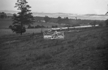
Photograph, George Burton Coop, The Royal Train enroute to Lilydale, near Croydon, 6 Mar. 1954
Believed to have been taken bewteen Croydon Railway Station and the Dorset Road bridge. Taken late afternnon by George Coop's father. There is a Landrover parked on the grass with a person standing on it - believed to be Security. George recalls originally being located closer to the fence and being ushered up the hill where it was 'safer' to stand. In 1954 at age 27, Queen Elizabeth II was the first reigning British monarch to visit Australia.. She visited Victoria between March 1-10. Where to see the Queen (1954, January 21). Fern Tree Gully and District Times (Boronia, Vic. : 1953-1954), p. 5. Retrieved October 25, 2021, from http://nla.gov.au/nla.news-article264220429 “The Lilydale Shire President, Cr. Burgi, stated that the Royal train en route for Warburton on Saturday, March 6th, would slow down at Croydon and Lilydale. There was little possibility that it would stop at either of these towns. The train would pass through Lilydale at 5.52 p.m. Council had appointed a sub-committee to arrange matters, and had allocated £400 towards expenses. It was suggested that the train slow down between the railway station and Dorset Rd. bridge at Croydon, and between the Cave Hill Quarry and railway station at Lilydale.” An album of images of the Queen's visit to Victoria is available on the PROV Flickr account at https://www.flickr.com/photos/public-record-office-victoria/7252885616Digital TIFF file Scan of Kopdak 620 black and white negative transparencygeorge coop collection, croydon, royal train -
 Eltham District Historical Society Inc
Photograph, George Burton Coop, The Royal Train enroute to Lilydale, near Croydon, 6 Mar. 1954
Believed to have been taken bewteen Croydon Railway Station and the Dorset Road bridge. Taken late afternnon by George Coop's father. There is a Landrover parked on the grass with a person standing on it - believed to be Security. George recalls originally being located closer to the fence and being ushered up the hill where it was 'safer' to stand. In 1954 at age 27, Queen Elizabeth II was the first reigning British monarch to visit Australia.. She visited Victoria between March 1-10. Where to see the Queen (1954, January 21). Fern Tree Gully and District Times (Boronia, Vic. : 1953-1954), p. 5. Retrieved October 25, 2021, from http://nla.gov.au/nla.news-article264220429 “The Lilydale Shire President, Cr. Burgi, stated that the Royal train en route for Warburton on Saturday, March 6th, would slow down at Croydon and Lilydale. There was little possibility that it would stop at either of these towns. The train would pass through Lilydale at 5.52 p.m. Council had appointed a sub-committee to arrange matters, and had allocated £400 towards expenses. It was suggested that the train slow down between the railway station and Dorset Rd. bridge at Croydon, and between the Cave Hill Quarry and railway station at Lilydale.” An album of images of the Queen's visit to Victoria is available on the PROV Flickr account at https://www.flickr.com/photos/public-record-office-victoria/7252885616Digital TIFF file Scan of Kopdak 620 black and white negative transparencygeorge coop collection, croydon, royal train -
 Bendigo Military Museum
Print - PRINT, FRAMED
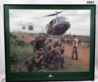
Caption under print. Soldiers of 5 Platoon, B Company, 7 RAR, preparing to board VS Iroquois helicopters during operation Ulmarrah, the cordon and search of Lang Phuoc Hai Village, South Vietnam, 26 August 1967". Members of 5 Platoon, B Company, 7th Battalion, The Royal Australian Regiment (7RAR), just north of the village of Lang Phuoc Hai, beside Route 44 leading to Dat Do. United States Army Iroquois helicopters are landing to take them back to Nui Dat after completion of Operation Ulmarra, the cordon-and-search by 7RAR of the coastal village of Lang Phuoc Hai. Operation Ulmarra was conducted by 2nd Battalion, The Royal Australian Regiment (2RAR) and 7RAR with support elements. Left to right: Private (Pte) Peter Capp (kneeling); Pte Bob Fennell (leaning over, facing camera, with an ammunition belt for an M60 machine gun slung over his shoulder); Corporal Bob D'Arcy (partly obscured behind Fennell); Pte Neal Hasted (centre, front); Pte Ian Jury (partly obscured, centre, rear, holding rifle); Pte Colin Barnett (front, right, M60 ammunition belt on back, back of head to camera); Lance Corporal Stan Whitford (partly obscured behind Barnett); the helicopter marshal at right is Pte John Raymond Gould, 7RAR. The United States Army Iroquois UH-1D helicopter was operated by 2 Platoon, 162nd Assault Helicopter Company, 11th Combat Aviation Battalion. (Having achieved almost the status of an icon, this image was chosen for, and is etched on, the Australian Vietnam Forces National Memorial on Anzac Parade, Canberra, ACT, dedicated in October 1992). Source AWM Print donated and dedicated to 3789179 FRANK FRIGERIO, 5 Platoon, B Company, 7RAR. See also Cat No. 3543-3549.3Print - coloured print of a photograph depicting three helicopters coming in to land above a dirt road with several groups of soldiers in uniform with jungle vegetation in the background. Frame - black painted metal.See in context, historical - caption under print.prints, framed, accessories, vietnam war -
 Bendigo Military Museum
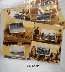
Photograph - PHOTOGRAPHS WW1, Originals: 1915
The photos in the collection relate to Thomas Robert JONES No 1982 AIF. Refer Reg No 1377 for his service details..1) - .22) Photos, black / white, showing men, training, the desert, Dardanelles, Turkish prisoners, leaving Egypt. .23) - .44) Enlargement copies of photos .1) - .22), sepia.Hand written on the rear in pen: .1) Housing parade on the desert Egypt, bugler band 6th Battalion. .2) Australian Field Artillery exercising horses near the pyramids. .3) Some of the buglers of the 6th Battalion with their identification disks as eyeglasses. .4) Serving out rations. .5) 6th Battalion having a short halt during a route march on the desert. .6) 18 Pounder Field Gun Australian Artillery. .7) 'Come to the Cook House Door' 6th Battalion AIF. .8) Lieut WATSON - Machine Gun being vaccinated by Lieut BALFE A Coy. Both these Officers are amongst the fallen. .9) 6th Battalion AIF preparing to leave Mena Camp for the Dardanelles. .10) A Turk captured on the morning of 25th April 1915 on board the troop ship Galeka. .11) Wounded alongside of hospital ship Galeka. .12) HMS Vengeance at the Dardanelles. .13) Hospital ship Sudan off Gaba Tepe. .14) Observation balloon off Cape Helles. .15) British Destroyer off Cape Helles. .16) Cape Helles, Dandanelles. .17) Turkish prisoners captured at the Suez _ _ _ Barracks, Cairo. .18) Turkish prisoners. .19) <> Guides near pyramids Mena. .20) Method of irrigation on the Nile, Egypt. .21) Going on leave into Cairo. .22) View of Cairo mosques in foreground taken from the Citadel. .23) - .44) On rear in stamp form: Dennis Major, 7 Bancroft St Bendigo Vic 3550. Tel & fax 03 544 2445 photography, military, ww1 -
 Bendigo Military Museum
Photograph - PHOTOGRAPH, FRAMED
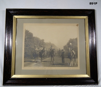
Brown wooden outer frame with gold inner boarder. Glass front, sepia photo mounted on grey background. Brown paper backing on frame. Depicts civilian giving directions to Bushmen mounted on horses, trees are in the background.Bushmans Contingent at Aspendale Park on route Langwarrin to South Africa. 'Stockings' troop horse No 5.photography-photographs, frame accessories -
 Bendigo Military Museum
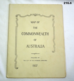
Map - MAPS, 1937
Items saved by Maurice Anthony BYRNE RAAF. Refer Cat No 215.9 for service history..1) map details on the map with biro lines marking the route taken by a traveller 1937 .2) map printed both sides Western New Guinea B6 December 1943 .3) map sheet B6 January 1944 top part of Australia .4) map Australia north plotting sheet .5) map C4 June 1943 .6) map Australian Aeronautical C5 June 1943documents - maps, military equipment -
 Halls Gap & Grampians Historical Society
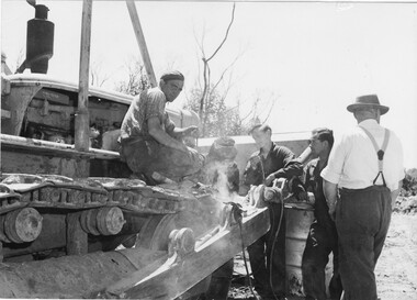
Photograph - B/W
Photo shows 5 men surrounding bulldozer. One is looking straight at camera, another is u;sing welding equipment.access routes, roads, access routes, mt william road -
 Halls Gap & Grampians Historical Society
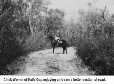
Photograph - B/W
... us she was 7yrs old when this photo was taken, c1934-5 ACCESS ...Young woman is Chick Anderson (nee Warren) riding on the Dunkeld Road. It is said that this was a better section of the road. Chick has told us she was 7yrs old when this photo was taken, c1934-5a young woman seated on a horse on a sandy track surrounded by thick bush.Chick Anderson on Dunkeld Rd 1934-35 written on backaccess routes, grampians/dunkeld rd, people, warren -
 Eltham District Historical Society Inc
Photograph, Spring Excursion, Hume and Hovell bus tour Stage 2, Seymour, Benalla; 26 Oct 1997, 26/10/1997
MONUMENT HUNTING THE HUME AND HOVELL WAY (Newsletter No. 117, November 1997, by Diana Bassett-Smith) Sunday October 26 1997 dawned bright and very warm. Some twenty-five members, complete with picnic baskets, met outside the Eltham Library awaiting the Cobb and Co. large coach which would be taking us on the second leg of our travels along the route of the early explorers Hume and Hovell. Stephen West was our very good driver for the day. He would be guided around the circuitous route by Russell Yeoman wh9 had made a detailed study, not only of the intended route, but of the story of these two explorers. During the trip Russell regaled us with poetry, quotations from the Journals and the History of the Shire of Seymour, "The New Crossing Place: by Martindale, 1982, (now Mitchell Shire due to the recent amalgamations). We headed towards the Hume Highway via Greensborough and Cooper Street and proceeded north to our first stop, noting on the way Monument Hill in the distance which is near Kilmore and, according to Russell, well worth the effort to visit as the view across the valley is magnificent. Past Sunday Creek Valley, Mt Piper and Mt Disappointment, all traversed and noted and named by them. We passed through Tallarook, then onto Seymour where we took photos of the monument telling us that Hume and Hovell had passed through on the 28th of October 1824. We also deviated down Hume and Hovell Road viewing deer and emu farming and the Bellbourie property now a sanctuary. Leaving Seymour behind we travelled up the Avenel Road to the Avenel monument, pyramidal in design of four reducing square blocks with a sharply pointed peak, erected in 1924 in memory of the 1824 exploration. The day was warming up and the countryside showing the dryness of the current drought. A parallel note had been made in their journal too of 1824 of the drought appearance of the country they were traversing. At Seven Creeks, Euroa we stopped for some minutes to check the monument placed 20th November 1924 to commemorate their passage on the 29th December 1824. More photos. Russell had pointed out the abrupt termination of the distant ranges which is noted in their journal. The next monument is beside the road at the entrance to Honey Suckle Creek Caravan Park, Violet Town. The squarish shaped monument some eight feet high is topped with a simple steel cross, and was to mark the date of 28th December 1824 and built for the 20th November 1924. By now it was 12.20 and nearly lunchtime as we drove along the Warranbayne Road to Roach's Road, monument hunting without success. Though there is a large, what appears to be an old timber sign which was hard to read, maybe this was the lost monument. In many of the paddocks hay had been cut and baled or was being cut, what a contrast to the rugged country they had passed through which was smoky from the fires of the natives burning off By 1.00 pm we were at Benalla and pulled up beside the park where abundant beds of roses filled the air with their scent and the smell of barbecued food twitched the nostrils whilst the cheerful sounds of other picnickers could be heard throughout the park. We left the bus and collected up our picnics, dispersed to the various tables and enjoyed the shade from the various European trees. 2.00 pm and we were on the road again driving along the Benalla, Mansfield, Yea road. The Swanpool monument states that they passed four miles south and returned three miles north. Then we stopped at the Barjarg monument which notes that they camped near this spot. It is again a pyramidal monument and this time topped with a steel arrow indicating their route of the 29th November 1824. Half an hour later we came to another monument, again with a steel arrow marker on top and the plaque dated the 2nd of 12th 1824. Erected on the 12th of 12th 1924. "They blazed the way that we might inherit the land." Another square based and needle topped monument appeared at Yarck near Yea and this plaque records the date of 3 December 1824. Near McGuigans Road Russell related that the expedition had lost a dog but it had found them next day, the dog was apparently torn by a kangaroo. A short while later Russell reminded us here of the problems they encountered in crossing the Goulburn River near Molesworth where banks were high, water deep and wide. "Good coat of grass but quite dry due to drought". At Yea we stopped for afternoon tea and raided the last of our picnics and looked at the monument to their journey of 1824, situated at a corner of the gardens near the bowling green. No photo – we were out of film. We returned home via Kinglake West and Whittlesea past the Yan Yean Reservoir, not full. 5.00 pm back at Eltham we emptied out of the bus and everyone, including Joan Cole, collected their things, Joan also had the major souvenir of the day, a large carp she had picked up from the river bank, her cat was in for a great feast. The day was made so interesting by the informed commentary which Russell provided. His background knowledge of the route and nature of the journey could only have come from many hours of reading and driving the area. Thank you to Russell and to everyone who made the day so informative and pleasurable. Diana Bassett-Smith. Record of the Society's history of activities - Spring 1997 excursionRoll of 35mm colour negative film, 2 stripsKodak Gold 400-5shire of eltham historical society, activities, pretty hill, seymour, benalla, hume and hovell, monuments -
 Eltham District Historical Society Inc
Negative - Photograph, Mail coach en route to Hurstbridge, c.1922
Coach with flaps takes aboard passengers. It travelled between Kinglake and Hurstbridge. The vehicle has advertising on the side indicating: W. BODY. HURSTBRIDGE bread and pastry. The Advertiser on 15 Sep 1922 has a display advertisement on page 2 indicating that Hurstbridge bakery 'W. Body wishes to notify the Public of Hurstbridge and surrounding district that he has purchased Mr Oliver's business'. The Advertiser, Friday 10 November 1922, page 2: Mr J. D. Chalmers, who runs the motor service from Hurstbridge to Kinglake, has just had a large, body built on a two-ton motor, which will be serviceable for either 25 passengers or general goods. The work was entrusted to Mr. D.G. Graham, motor and coach builder, Hurstbridge, who completed it within a month, the finish, painting, etc.. being quite up to the standard of a city shop. The mail coach operated the route between Kinglake and Hurstbridge motor route, on which Mr. Sharpe had pioneered and run a motor mail route with a bus which carried 20 passengers, for many years but Sharpe's license for his motor bus was refused by the Country Roads Board mid 1930 as his bus was considered too large . In February 1935, Mr Sharpe was granted a license to carry passengers between Hurstbridge and Kinglake and Mr Kell between Kinglake and Hurstbridge. In 1936 the mail contract from Heidelberg to Knglake was via car and members of the community were concerned that there was no further any conveyance of passengers from Hurstbridge to Kinglake.This photo forms part of a collection of photographs gathered by the Shire of Eltham for their centenary project book,"Pioneers and Painters: 100 years of the Shire of Eltham" by Alan Marshall (1971). The collection of over 500 images is held in partnership between Eltham District Historical Society and Yarra Plenty Regional Library (Eltham Library) and is now formally known as 'The Shire of Eltham Pioneers Photograph Collection.' It is significant in being the first community sourced collection representing the places and people of the Shire's first one hundred years.Digital image 4 x 5 inch B&W Neg 9 x 12.5 cm B&W printsepp, shire of eltham pioneers photograph collection, kinglake, mail coach, w. body, public transport, bus, bus travel, hurstbridge, pioneers and painters -
 Eltham District Historical Society Inc
Photograph, Murchison Gap, Autumn Excursion, Hume and Hovell's 1824 expedition, 26 May 1996, 26/05/1996
[article by Bettina Woodburn in EDHS Newsletter No. 109, July 1996:] ON THE TRAIL OF HUME AND HOVELL - REPORT ON THE AUTUMN EXCURSION - On a green and fresh morning (Sunday 26th May 1996) the Cobb and Co coach (driven by the most obliging Peter Tampion) set off in a north easterly direction from Eltham to connect with Hume and Hovell's route on their 1824 explorations of central Victoria. The Society would follow a series of monuments erected for the 1924 centenary of the expedition from King Parrot Creek (Tuesday 7th December 1824), through Strath Creek, over Sunday Creek (Sunday 12th December 1824) at Broadford, Tullamarine, St Albans, Deer Park, through Werribee, skirting east of the You Yangs to Lara and Avalon Beach. Because their distance-measuring wheel had broken and a one degree mistake was made in calculations, the two leaders of the original group of six convict-companions arrived at Corio Bay, instead of the expected Western Port, discovered earlier by Flinders. From below Mt. Disappointment (Hume and Hovell's difficulties in "scrambling over brush and rock", "leeches in forest, as well as no water", "cutting grass 4-5 ft. high", dreadful scrub", "devil flies") we took an easier route, saw the Strath Creek memorial in ground fog and a wonderful "field of dreams", the Hume-Hovell privately owned cricket ground with its white picket boundary fence. Now, after a steep climb, in sunshine under gums we stretched and viewed magnificent rolling hills and fog-filled valleys - not "smoke from Aborigines' bush fires". After morning tea at Broadford we followed the Sunday Creek valley beside the Hume Freeway, passed the Wallan Wallan Rest Area (more appropriately Hume and Hovell Rest Area) to tum right at Beveridge. In Gellibrand Hill Park, near the headwaters of the Moonee Ponds Creek, we experienced the landscape the first European settlers saw - huge river red gums and rolling pastures. The gardens and sheltered courtyard of the 1840s, timber, brought from .....[?] prefabricated Woodlands Homestead, provided a pleasant lunch stop. We enjoyed a private tour, panoramic views over Melbourne and surroundings and the excitement of arriving and departing aircraft. Our next river crossing was at Werribee, "in a vast treeless plain", then we drove on by-ways no coach had previously travelled, to find "an immense sheet of water" salty Corio Bay, off-course to the west. In late afternoon of a super, calm, late autumn day we headed homewards. Back at Eltham we were rather surprised to find that we had travelled a total of 347 km. Thanks again to Russell Yeoman for his research and organization. What a wonderful day! Three colour photographsactivities, murchison gap, murchison valley -
 Eltham District Historical Society Inc
Photograph, Hume and Hovell Monument, Broadford, Autumn Excursion, Hume and Hovell's 1824 expedition, 26 May 1996, 26/05/1996
[article by Bettina Woodburn in EDHS Newsletter No. 109, July 1996:] ON THE TRAIL OF HUME AND HOVELL - REPORT ON THE AUTUMN EXCURSION - On a green and fresh morning (Sunday 26th May 1996) the Cobb and Co coach (driven by the most obliging Peter Tampion) set off in a north easterly direction from Eltham to connect with Hume and Hovell's route on their 1824 explorations of central Victoria. The Society would follow a series of monuments erected for the 1924 centenary of the expedition from King Parrot Creek (Tuesday 7th December 1824), through Strath Creek, over Sunday Creek (Sunday 12th December 1824) at Broadford, Tullamarine, St Albans, Deer Park, through Werribee, skirting east of the You Yangs to Lara and Avalon Beach. Because their distance-measuring wheel had broken and a one degree mistake was made in calculations, the two leaders of the original group of six convict-companions arrived at Corio Bay, instead of the expected Western Port, discovered earlier by Flinders. From below Mt. Disappointment (Hume and Hovell's difficulties in "scrambling over brush and rock", "leeches in forest, as well as no water", "cutting grass 4-5 ft. high", dreadful scrub", "devil flies") we took an easier route, saw the Strath Creek memorial in ground fog and a wonderful "field of dreams", the Hume-Hovell privately owned cricket ground with its white picket boundary fence. Now, after a steep climb, in sunshine under gums we stretched and viewed magnificent rolling hills and fog-filled valleys - not "smoke from Aborigines' bush fires". After morning tea at Broadford we followed the Sunday Creek valley beside the Hume Freeway, passed the Wallan Wallan Rest Area (more appropriately Hume and Hovell Rest Area) to tum right at Beveridge. In Gellibrand Hill Park, near the headwaters of the Moonee Ponds Creek, we experienced the landscape the first European settlers saw - huge river red gums and rolling pastures. The gardens and sheltered courtyard of the 1840s, timber, brought from .....[?] prefabricated Woodlands Homestead, provided a pleasant lunch stop. We enjoyed a private tour, panoramic views over Melbourne and surroundings and the excitement of arriving and departing aircraft. Our next river crossing was at Werribee, "in a vast treeless plain", then we drove on by-ways no coach had previously travelled, to find "an immense sheet of water" salty Corio Bay, off-course to the west. In late afternoon of a super, calm, late autumn day we headed homewards. Back at Eltham we were rather surprised to find that we had travelled a total of 347 km. Thanks again to Russell Yeoman for his research and organization. What a wonderful day! Colour photographactivities, broadford, hume and hovell, monument -
 Eltham District Historical Society Inc
Photograph, Hume and Hovell Monument, Autumn Excursion, Hume and Hovell's 1824 expedition, 26 May 1996, 26/05/1996
[article by Bettina Woodburn in EDHS Newsletter No. 109, July 1996:] ON THE TRAIL OF HUME AND HOVELL - REPORT ON THE AUTUMN EXCURSION - On a green and fresh morning (Sunday 26th May 1996) the Cobb and Co coach (driven by the most obliging Peter Tampion) set off in a north easterly direction from Eltham to connect with Hume and Hovell's route on their 1824 explorations of central Victoria. The Society would follow a series of monuments erected for the 1924 centenary of the expedition from King Parrot Creek (Tuesday 7th December 1824), through Strath Creek, over Sunday Creek (Sunday 12th December 1824) at Broadford, Tullamarine, St Albans, Deer Park, through Werribee, skirting east of the You Yangs to Lara and Avalon Beach. Because their distance-measuring wheel had broken and a one degree mistake was made in calculations, the two leaders of the original group of six convict-companions arrived at Corio Bay, instead of the expected Western Port, discovered earlier by Flinders. From below Mt. Disappointment (Hume and Hovell's difficulties in "scrambling over brush and rock", "leeches in forest, as well as no water", "cutting grass 4-5 ft. high", dreadful scrub", "devil flies") we took an easier route, saw the Strath Creek memorial in ground fog and a wonderful "field of dreams", the Hume-Hovell privately owned cricket ground with its white picket boundary fence. Now, after a steep climb, in sunshine under gums we stretched and viewed magnificent rolling hills and fog-filled valleys - not "smoke from Aborigines' bush fires". After morning tea at Broadford we followed the Sunday Creek valley beside the Hume Freeway, passed the Wallan Wallan Rest Area (more appropriately Hume and Hovell Rest Area) to tum right at Beveridge. In Gellibrand Hill Park, near the headwaters of the Moonee Ponds Creek, we experienced the landscape the first European settlers saw - huge river red gums and rolling pastures. The gardens and sheltered courtyard of the 1840s, timber, brought from .....[?] prefabricated Woodlands Homestead, provided a pleasant lunch stop. We enjoyed a private tour, panoramic views over Melbourne and surroundings and the excitement of arriving and departing aircraft. Our next river crossing was at Werribee, "in a vast treeless plain", then we drove on by-ways no coach had previously travelled, to find "an immense sheet of water" salty Corio Bay, off-course to the west. In late afternoon of a super, calm, late autumn day we headed homewards. Back at Eltham we were rather surprised to find that we had travelled a total of 347 km. Thanks again to Russell Yeoman for his research and organization. What a wonderful day! Two colour photographsactivities, hume and hovell, monument -
 Orbost & District Historical Society
cutlery, first half 20th century
MS Princess of Tasmania was an Australian-built roll-on/roll-off passenger ship, built by the State Dockyard in Newcastle, New South Wales for the Australian National Line. Laid down on 15 November 1957, she was launched on 15 December 1958. The Princess of Tasmania sailed on her maiden voyage on 23 September 1959. On entering service, she was used on the Devonport to Melbourne route across Bass Strait. The ship continued operating until 1972, Five silver-plated forks and one spoon. The sugar spoon is a souvenir of the Princess of Tasmania. 1590.2 and .5 are narrow forks. 1590.3 and .4 have splayed tines. 1590.6 is a cake fork.On back of spoon : EP&NS *1 Various marks on backs of forks with EP&NScutlery silver-plated princess-of-tasmania