Showing 624 items
matching towns> r.
-
 Glenelg Shire Council Cultural Collection
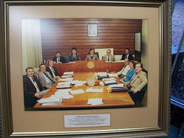
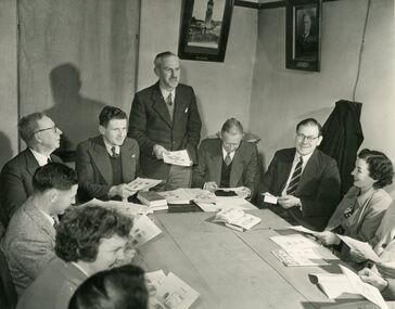
Photograph, Photograph - Portland Town Council, 1981, 1981
Glenelg Shire Council RecordsColour photograph of Portland Town Council (10 men, 1 woman) in a meeting. Mounted under glass in brown matt and gold-painted wooden frame.Front: Portland Town Council/Meeting of Council on Tuesday, 3rd November 1981. Left to right: Cr. R. Halliday, Cr. K. Wilson, Cr. G. Dawson, Mr. J. Costello (Deputy Town Clerk), Mr. P. Shanahan (Town Clerk), Cr. L. Murrell (Mayor), Mr. P. Cooper (Town Engineer), Mr. N. Buckingham (Deputy Town Engineer), Cr. I. Foley, Cr. L.J. Davis, Cr. J. Patterson. Absent: Cr. M.E. Box and J.H. Templar. Presented at a Special Meeting of Council held on Monday, 16th November, 1981 to mark one hundred and twenty-six years of Local Government in Portland (label, lr centre). -
 Glenelg Shire Council Cultural Collection
Medal - Medal, Royal Visit of Queen Elizabeth II, c. 1954
Commemorative medal commissioned by the Victorian state government as a souvenir of the Royal Visit by Queen Elizabeth II and the Duke of Edinburgh to Victoria in 1954. The medal was presented to all Victorian school children. It was struck by Stokes & Sons of Melbourne. The Queen and Prince Philip visited Victoria from 24 February to 9 March 1954. The first reigning monarch to tour Australia, she arrived in Sydney on 3 February 1954 and departed the country from Fremantle on 1 April 1954. The Royal party visited all the capital cities apart from Darwin, and over 70 country towns.Bronze medal, hanging from a rectangular bar. The obverse of the medal features profile portraits of the Queen and Prince Philip. Presented to children of Victoria on Royal Visit, 1954Obverse: bust of Elizabeth II and Duke of Edinburgh Reverse: E II R Royal Visit/ 1954/ Victoriamedal, queen elizabeth ii, 1954, royal visit, victoria, numismatics, celebrations, schools -
Glenelg Shire Council Cultural Collection
Financial record - Financial record - Rate notice Portland Town Council, 23 Short St Portland, Victoria, 23/03/1964
a) Rate notice issued by Portland Town Council for 23 Short St Portland, to Mrs Dawn R Barclay b) Receipt for above, dated 14 Apr 1964 c) Town of Portland envelope, containing a) and b) -
Glenelg Shire Council Cultural Collection
Photograph - Photograph - Casterton Island Park, c. 1963
Sourced from Casterton Town Hall (Former Shire of Glenelg)Black and white phot. Island Park Casterton, looking across oval to C. R. Gill pavilionBack: 'Island Park Oval Casterton' - handwritten, green biro -
Glenelg Shire Council Cultural Collection
Award - Wooden Plaque - Syd Cuffe, Portland Town Crier, 1996
Second place - best cry. Wooden plaque awarded to Syd Cuffe, in shape of scroll, two gold shields. Yellow sticker on reverse, with suppliers detailsFront: 'BEST CRY 2ND PLACE A.H.?G.A.T.C. 1996 engraved on upper shield 'Syd Cuffe Portlan' engraved on lower shieldsyd cuffe, portland town crier -
Glenelg Shire Council Cultural Collection
Photograph - Photograph - Shire of Glenelg Councillors, c. 1963
Sourced from Casterton Town Hall (Former Shire of Glenelg)Black and white photo. Shire of Glenelg Councillors, 1962/1963 South Riding. Left to right- F. H. Silvester, C. Emerson, D. W. Matheson, sitting behind desk with Honour Board behind them on wall - Past Presidents of Shire of Glenelg, 1863 - 1963. Council Chambers Casterton Town HallBack: Black stamp '003635' Blue biro line, arrowed each end, drawn across photo. '3" ' above line 'Councillors 1962/3 South Riding L. to R. Cr. F.H. Silvester Cr. C. Emerson Cr. D. W. Matheson' handwritten in pencil. Letter 'C' in black birof h silvester, c emerson, d w matheson -
Glenelg Shire Council Cultural Collection
Photograph - Photograph - Shire of Glenelg Councillors, c. 1963
Sourced from Casterton Town Hall (Former Shire of Glenelg)Black and white photo. Three councillors for the Central Riding, Shire of Glenelg 1962/3, sitting behind desk, Honour Board on wall behind them, with names of Past Presidents of the Shire of Glenelg, 1863 - 1963 Left to right: H. D Mitchell, J.J. Howlett, J. R Hargreaves Council chambers, Casterton Town HallBack: Black stamp '003635. Letter 'A' heavy pencil. Blue biro line, arrowed each end, drawn across photo. '3" ' above line. 'Councillors central Riding 1962/3 '1/4 black' -pencil L to R Cr H.D. Mitchell Cr. JJ. Howlett Cr. J.R. Hargreaves' - handwritten pencil -
Glenelg Shire Council Cultural Collection
Photograph - Photograph - Shire of Glenelg Councillors, c. 1963
Sourced from Casterton Town Hall (Former Shire of Glenelg)Black and white photo. Three East Riding Councillors for Shire of Glenelg, sitting at desk, Honour Board on wall behind them with names of Past Presidents of the Shire of Glenelg 1863 -1963 Left to right T. J. Carey (in glasses), D. P. Mullane, J. P. Neylon, Council chambers, Casterton Town HallBack: Black stamp ;\' 003826' ' B' pencil Blue biro line arrowed both ends, drawn across photo. '3" ' above line ''Councillors East Riding' L to R Cr T.J Carey Cr. D. P. Mullane Cr. J.P. Neylon' handwritten in blue birotj carey, d p mullane, jp neylon -
 Kiewa Valley Historical Society
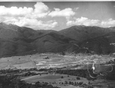
Photograph of Kiewa Valley Panorama, Kiewa Valley from No. 5 Road, Before 1945
In 1943 a camp for workmen was erected and a commencement made with the erection of plant storage and workshop buildings in the new township of Mt. Beauty. The photograph was probably taken after the completion of these buildings. There is no sign of construction of the town itself. In the latter part of 1945 work was commenced on the Mt. Beauty township area with a medical centre, general trading store and some houses under construction. The No. 5 Road, from where the photograph was taken, is the road to West Kiewa Power Station and Big Hill Scenic Lookout.Is an excellent view of the Kiewa Valley before there was little work undertaken to establish the town of Mt. Beauty. Farming was well established with the evidence of huge areas of cleared land. The junction of the East and West Kiewa Rivers can be clearly seen. The first Workmen's camp is near the river and some workshop buildings can also be seen. Black and white photograph of the Kiewa Valley, looking North.Handwritten on the back of photograph "Kiewa Valley from No. 5 Road".kiewa valley, camp, buildings, mt. beauty -
 Kiewa Valley Historical Society
Photograph of Mt. Beauty, Mt. Beauty from transmission line, Approx 1950/51
This photo is of the very newly constructed State Electricity Commission town of Mt. Beauty. The houses up to Nelse street were erected from 1946 onward and then the township was extended beyond Nelse Street in 1950 which places this photograph about 1950/51. There is no evidence of work being commenced on the regulating pondage but the tail race canal can be seen on the centre right of photo. The workmen's camp was enlarged in 1950 to the extent of providing accommodation for a total of 1,200. There are a number of dwellings on Simmonds Creek and the road to Falls Creek can clearly be seen. Snow capped Mt. Bogong is in the upper left of the photo with Mt. Beauty behind the township rising to Big Hill beyond that.Shows the newly constructed town of Mt. Beauty surrounded by farmland and before the regulating pondage was built to discharge water from the power stations via the West Kiewa tail race tunnel into the Kiewa River. Black and white photographHand written on back of photograph "Mt. Beauty from Transmission Line"mt. beauty, construction, pondage, state electricity commission -
 Kiewa Valley Historical Society
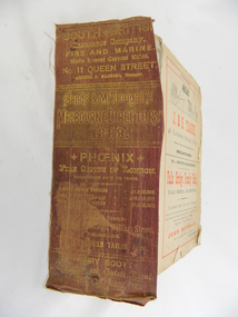
Book - Reference Melbourne Directory, Melbourne and Suburban Directory for 1889, Circa 1889
This Directory of 1889 covers the location of Melbourne based trade and professional offices by street and in Alphabetical order. It covers all of Melbourne and its suburbs. It also covers government and official, ecclesiastic, legal, municipal and miscellaneous information. The directory details a cross section of a developing city with a splattering of advertisements opening up an in depth look of all aspects of living in the late 1800s. It is interesting to see that all the advertisements do not have any telecommunication numbers listed (personal shoppers or mail orders only). This was a period of high moral standing within the community and hotels advertised rooms " suites of rooms for families and single rooms for Ladies and Gentlemen" also "electric bells throughout the house. Telephone, night porter and hot and cold baths."This directory would be used by the majority of families and businesses working and living within the Kiewa Valley and the surrounding area. Melbourne was the only place where every aspect of living requirement was catered for. Although the delivery of services and goods were not at a high rate, certain items or transactions would require a visit to "the big smoke". Business information are listed both by suburb and alphabetically. There is also a section for British and Foreign Trade. This directory covered nearly everything to do with commerce, an example pay days for principle firms. Greater evolution of trade locations started to balloon out after the mid 1950's. Increased populations and greater levels of communication and safe fast transport facilities permitted greater devolution of commercial enterprises into rural communities, such as the Kiewa Valley.This directory has no front or back cover and is held together by its cloth spine. It contains over 1300 pages, however there may be some pages missing front and back of the directory which would have contained advertisements of some unknown shops. All the sides of this directory (except the spine) have advertisements and content information stamped on. The spine cover has been placed in the directory until further conservation work is carried out. It has gold coloured printing and in the central section, a gold coloured background with the words "Sands & McDougall's Melbourne Directory 1889." The spine has three adverts on the spine.On the spine in gold colour "South * British insurance Company Fire and Marine. Risks Lowest Current Rates No. 11 Queen Street, Arthur J Masters, Manager" and half way down " *Phoenix* Fire Office of London established over 100 years Annual Income exceeds (pound sign) 1,000,000" underneath "Losses Paid Over (pound sign) 16,000,000" underneath "Reserve Fund Exceeds (pound sign) 1,000,000" underneath "9 Market Buildings William Street, Melbourne " underneath " R. Manfield Taylor, Agent" and at the bottom section" Henry Scott Auctioneer and Estate Agent 49 Bridport St., Albert Park" stamped on the bottom side across the page endings "The Wonderful Wertheim Sewing Machines Swanston Street opposite Town Hall", stamped on the top side across the page endings " The Sweet Hapsburg Pianos & Organs Swanston Street Opposite Town Hall"state government listings, names and location of early melbourne population business names, 1889 members of the victorian executive council -
 Warrnambool and District Historical Society Inc.
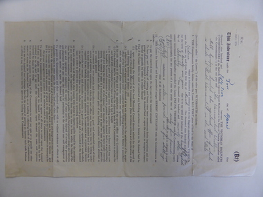
Document, Lease of Land by Victorian Railways to Warrnambool Woollen Mill Co Ltd, 1952
The Warrnambool Woollen Mill was established in 1910 in South Warrnambool by a local company, with the building erected on a site that formerly housed another woollen mill destroyed by fire in 1882. The Warrnambool Woollen Company operated successfully for many years with over 700 employees in the 1940s and a good national reputation for quality goods. It made blankets and other woollen goods and was the first company in Australia to manufacture electric blankets. In the 1960s the mill was sold to the Dunlop Company and for the next thirty years it was bought and sold several times, finally closing in 2000 after 90 years of operation. The woollen Mill was built on a site which was in easy access to the railway line which operated along the original tramway line from the town to the jetty. It is possible that this land would have been used for parking during the period of 1950's to 1970's which was a successful period of manufacturing and trade for the Woollen Mill. A link between an important infrastructure and one of Warrnambool's most important industries.Four page folded document cream in colour . Printed form with diagram of the land in question coloured in pink . Seals of both Victorian railways and Warrnambool Woollen mill are stamped beside signatories on page 3. Dated 30th April 1952. Signed R Naylor for the Warrnambool Woollen Mill and two unreadable signatures for Victorian Railways.warrnambool, warrnambool woollen mill, warrnambool railways, lease victorian railways and warrnambool woollen mill -
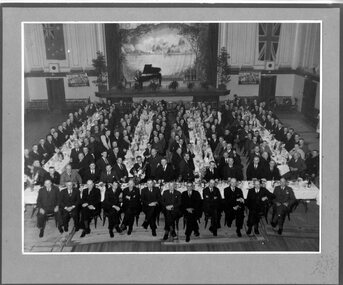 Victoria Police Museum
Photograph (Victoria Police), Police Officers on dinner event, February 1945
[see inscriptions] Black and white mounted photograph. Approximately 160 men (171 according to inscription on the back) sitting on large tables at a formal dinner event; all weatinh suits and posing for photograph. Photo was taken in a large rooom with a stage, Malvern Town Hall accoring to inscriptions on the back - tables occupy centre and front of photograph - but in the background: [left] Australia flag, WWII poster; [center] stage with painted landscape and piano; [right] WWII poster and Britain flag. [information of event on newspaper cutting stuck on the back - as described on Inscriptions]Handwritten: 171 PRESENT // FEB 1945 // (?) OFF SUPT KNOTT // INSPT SAMBLEBE // CONST GRAMBEU /// MALVERN TOWN HALL Newspaper cutting glued to frame: Supt. J. R. H. Knott, has rettired from the Police Force after 38 and half years' service, was farewelled by citizens and police officials at Malvern Town Hall on Tuesday night, The mayor of Malvern (Cr. J. Johnson) presided and presented SUpt. Knott with a chair and a wallet of notes. Similar presentations were made to Inspector C.H.D. Samblebe and First Constable O. Grambau, who have also retired. Supt. A.D. McKinnon of Ballarat will succeed Supt. Knott // handwritten: SUN 1/2/45victoria police museum, police officers, police academy, police force, superintendent mckinnon, superintendent knott, cr johnson, inspector samblebe, first constable grambau, poulter, william -
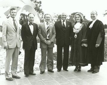
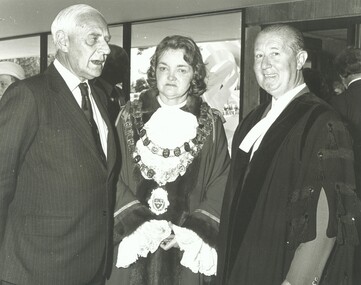 Ringwood and District Historical Society
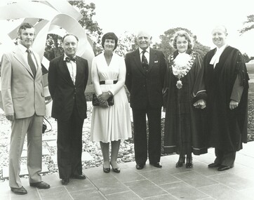
Photograph, Official opening of the Karralyka Centre, Mines Road, Ringwood on 19/4/1980 - L-R: Victorian Governor Sir Henry Winneke, Cr Pat Gotlib (Mayor), Arthur W Hall (Town Clerk), 19-Apr-80
Official opening of the Karralyka Centre - L-R Sir Henry Winneke, Cr Pat Gotlib (Mayor), Arthur W Hall (Town Clerk). +Additional Keywords: Winneke, Sir Henry (Governor of the State of Victoria) / Gotlib, Pat (Cr) / Hall, Arthur W. (Town Clerk) -
 Ringwood and District Historical Society
Photograph, Official opening of the Karralyka Centre, Mines Road, Ringwood on 19/4/1980 - L-R: Victorian Governor Sir Henry Winneke, Cr Pat Gotlib (Mayor), Arthur W Hall (Town Clerk), 19-Apr-80
Official opening of the Karralyka Centre - L-R Sir Henry Winneke, Cr Pat Gotlib (Mayor), Arthur W Hall (Town Clerk). +Additional Keywords: Winneke, Sir Henry (Governor of the State of Victoria) / Gotlib, Pat (Cr) / Hall, Arthur W. (Town Clerk) -
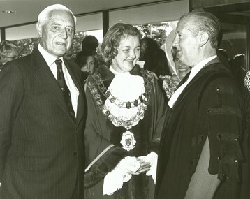
 Ringwood and District Historical Society
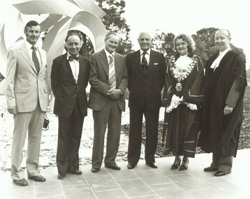
Photograph, Official opening of the Karralyka Centre, Mines Road, Ringwood on 19/4/1980, 19-Apr-80
Official opening of the Karralyka Centre - L-R A.C. Robertson (City Engineer), Harry Seidler (Architect), Sir Henry Winneke, Cr Pat Gotlib (Mayor), Arthur W Hall (Town Clerk). +Additional Keywords: Winneke, Sir Henry (Governor of the State of Victoria) / Gotlib, Pat (Cr) / Hall, Arthur W. (Town Clerk) / Robertson, Alan C. (City Engineer) / Seidler, Harry -
 Ringwood and District Historical Society
Photograph, Official opening of the Karralyka Centre, Mines Road, Ringwood on 19/4/1980 - L-R: A.C. Robertson (City Engineer), Harry Seidler (Architect), Lady Winneke - Ellis Fauld (uncertain), Victorian Governor Sir Henry Winneke, Cr Pat Gotlib (Mayor), Arthur W Hall (Town Clerk), 19-Apr-80
Official opening of the Karralyka Centre - L-R A.C. Robertson (City Engineer), Harry Seidler (Architect), Lady Winneke - Ellis Fauld (uncertain), Sir Henry Winneke, Cr Pat Gotlib (Mayor), Arthur W Hall (Town Clerk). +Additional Keywords: Robertson, Alan C. (City Engineer) / Seidler, Harry / Winneke, Lady (uncertain) / Winneke, Sir Henry (Governor of the State of Victoria) / Gotlib, Pat (Cr) / Hall, Arthur W. (Town Clerk) -
 Ringwood and District Historical Society
Photograph, Official opening of the Karralyka Centre, Mines Road, Ringwood on 19/4/1980 - L-R: A.C. Robertson (City Engineer), Harry Seidler (Architect), Cr Jack McRae, Victorian Governor Sir Henry Winneke, Cr Pat Gotlib (Mayor), Arthur W Hall (Town Clerk), 19-Apr-80
Official opening of the Karralyka Centre - L-R A.C. Robertson (City Engineer), Harry Seidler (Architect), Cr Jack McRae, Sir Henry Winneke, Cr Pat Gotlib (Mayor), Arthur W Hall (Town Clerk). +Additional Keywords: Robertson, Alan C. (City Engineer) / Seidler, Harry / McRae, Jack (Cr) / Winneke, Sir Henry (Governor of the State of Victoria) / Gotlib, Pat (Cr) / Hall, Arthur W. (Town Clerk) -
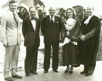
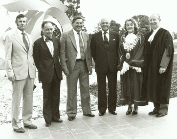
 Ringwood and District Historical Society
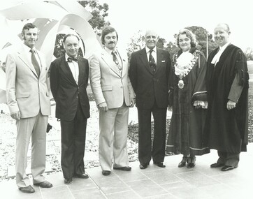
Photograph, Official opening of the Karralyka Centre, Mines Road, Ringwood on 19/4/1980 - L-R: A.C. Robertson (City Engineer), Harry Seidler (Architect), Cr Gerald Smart, Victorian Governor Sir Henry Winneke, Cr Pat Gotlib (Mayor), Arthur W Hall (Town Clerk), 19-Apr-80
Official opening of the Karralyka Centre - L-R A.C. Robertson (City Engineer), Harry Seidler (Architect), Cr Gerald Smart, Sir Henry Winneke, Cr Pat Gotlib (Mayor), Arthur W Hall (Town Clerk). +Additional Keywords: Robertson, Alan C. (City Engineer) / Seidler, Harry / Smart, Gerald (Cr) / Winneke, Sir Henry (Governor of the State of Victoria) / Gotlib, Pat (Cr) / Hall, Arthur W. (Town Clerk) -
 Ringwood and District Historical Society
Photograph, Official opening of the Karralyka Centre, Mines Road, Ringwood on 19/4/1980 - L-R: A.C. Robertson (City Engineer), Harry Seidler (Architect), (name unknown), Victorian Governor Sir Henry Winneke, Cr Pat Gotlib (Mayor), Arthur W Hall (Town Clerk), 19-Apr-80
Official opening of the Karralyka Centre - L-R A.C. Robertson (City Engineer), Harry Seidler (Architect), (name unknown), Sir Henry Winneke, Cr Pat Gotlib (Mayor), Arthur W Hall (Town Clerk). +Additional Keywords: Robertson, Alan C. (City Engineer) / Seidler, Harry / Winneke, Sir Henry (Governor of the State of Victoria) / Gotlib, Pat (Cr) / Hall, Arthur W. (Town Clerk) -
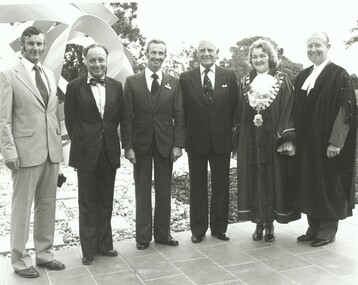
 Ringwood and District Historical Society
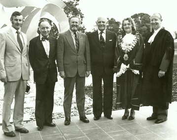
Photograph, Official opening of the Karralyka Centre, Mines Road, Ringwood on 19/4/1980 - L-R: A.C. Robertson (City Engineer), Harry Seidler (Architect), Cr Alan E Henderson, Victorian Governor Sir Henry Winneke, Cr Pat Gotlib (Mayor), Arthur W Hall (Town Clerk), 19-Apr-80
Official opening of the Karralyka Centre - L-R A.C. Robertson (City Engineer), Harry Seidler (Architect), Cr Alan E Henderson, Sir Henry Winneke, Cr Pat Gotlib (Mayor), Arthur W Hall (Town Clerk). +Additional Keywords: Robertson, Alan C. (City Engineer) / Seidler, Harry / Henderson, Alan E. (Cr) / Winneke, Sir Henry (Governor of the State of Victoria) / Gotlib, Pat (Cr) / Hall, Arthur W. (Town Clerk) -
 Ringwood and District Historical Society
Photograph, Official opening of the Karralyka Centre, Mines Road, Ringwood on 19/4/1980 - L-R: A.C. Robertson (City Engineer), Harry Seidler (Architect), Cr Frank Corr, Victorian Governor Sir Henry Winneke, Cr Pat Gotlib (Mayor), Arthur W Hall (Town Clerk), 19-Apr-80
Official opening of the Karralyka Centre - L-R A.C. Robertson (City Engineer), Harry Seidler (Architect), Cr Frank Corr, Sir Henry Winneke, Cr Pat Gotlib (Mayor), Arthur W Hall (Town Clerk). +Additional Keywords: Robertson, Alan C. (City Engineer) / Seidler, Harry / Corr, Frank (Cr) / Winneke, Sir Henry (Governor of the State of Victoria) / Gotlib, Pat (Cr) / Hall, Arthur W. (Town Clerk) -
 Ringwood and District Historical Society
Photograph, Official opening of the Karralyka Centre, Mines Road, Ringwood on 19/4/1980 - L-R: A.C. Robertson (City Engineer), Harry Seidler (Architect), Cr W.R. Wilkins, Victorian Governor Sir Henry Winneke, Cr Pat Gotlib (Mayor), Arthur W Hall (Town Clerk), 19-Apr-80
Official opening of the Karralyka Centre - L-R A.C. Robertson (City Engineer), Harry Seidler (Architect), Cr W.R. Wilkins, Sir Henry Winneke, Cr Pat Gotlib (Mayor), Arthur W Hall (Town Clerk). +Additional Keywords: Robertson, Alan C. (City Engineer) / Seidler, Harry / Wilkins, W.R. (Cr) / Winneke, Sir Henry (Governor of the State of Victoria) / Gotlib, Pat (Cr) / Hall, Arthur W. (Town Clerk) -
 Ringwood and District Historical Society
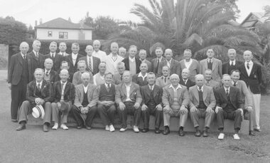
Photograph, Ringwood Bowls Club- Ringwood Council and Staff versus Ringwood Bowling Club, "Mayors Shield", 1947
... . Archbold, M. Flowers, R. Anderson, A. Long (Town Clerk), J.K...: (L to R). J. Archbold, M. Flowers, R. Anderson, A. Long (Town ...Black and white photograph (5 copies)Typed below photograph, "Ringwood Bowling Club - 1947". On back of photograph: Newspaper cutting titled "Bowls in the Early Days" with list of names. Front Row: (L to R). J. Archbold, M. Flowers, R. Anderson, A. Long (Town Clerk), J.K. McCaskill (Mayor), S. Hunt (Pres.), E. Tann, Sec., A. Ibbotson, C. Merry (Building Inspector). 2nd Row: C. Wedge, G. Wood, G. Devenish, J. Proundley, R. Wilkins, B. Hubbard, C. Ward, H. Watson, E. Purser, J. Bray (Engineer).Back Row: T. Williams, F. Caterer, A. Burgess, R. Ramsey, T. Roberts, E. McKibbon, G. Hood, T. Hall, H. Martin, J. Smith, J. Knox, Rev. Leewin, F. Moore, - Evans: J. Grenville (Dep. Town Clerk), G. Young, E. Moran". -
 Ringwood and District Historical Society
Photograph, Ringwood Horticultural Society Show Committee - March 1919, Mar-19
Black and white photographs- 2 large, 2 smaller copies. Photograph taken outside Mechanics Hall, later Ringwood Town Hall, 1919.Back Row (L to R) T Hamilton, - , Claude Howship, F Wright, Alf Bloom, - , Harry Brewer Middle Row Herman Pump, J Aird, AT Clarke JP, H Pratt, A Milner, Bessie Mackinlay, Tilley, Stuart C Wallace, P Laurie, Nick Madden Front Row W Everard MLA, PT Young, - , A Kennedy, L Burghard, F Pollard Photographer was Darge, The Soldier's Photographer, 176 Collins Street, Melbourne -
 Orbost & District Historical Society
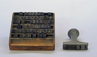
stamp holder and numbers, Victorian Government Railways, c. 1930s- 1980s
Used on the Orbost-Bairnsdale railway line which closed in 1987. The Bairnsdale-Orbost railway was opened in 1916 to serve the agricultural and timber industry. Because of the decline in traffic and heavy operating costs, the line was finally closed in August, 1987. Orbost Railway Station was opened on Monday 10 April 1916 as the terminus of the Orbost railway line, and closed in 1987. The station was located on the west side of the Snowy River despite the town of Orbost being on the east side of the river, in order to save on the costs of a bridge over the river, which at the time had highly variable levels This item is associated with the history of the Orbost-Bairnsdale railway line and therefore reflects the role that the rail line played in the social and economic history of Orbost.A stamp holder made of aluminium into which numbers and possibly letters can be inserted. Also a square shallow wooden box containing numbers which are used with the stamp. The numbers appear to be made of rubber.possibly V G R railway-history orbost-bairnsdale-railway -
 Orbost & District Historical Society
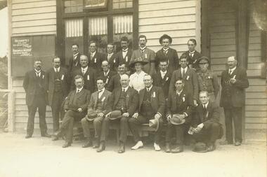
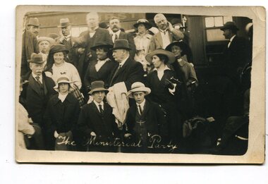
black and white photographs, April 1916
These photographs were taken at the official opening of the Orbost - Bairnsdale Railway Line. In 3150.3 which is of a group of children and two adults those identified in the photograph are ; L - R front row Mary Gilbert; Warren; Betty Gilbert; Marion Gilbert; Mrs Shaw and son; ? Gay; and Pen Gilbert. In 3150.4 L-R front " Mary Gilbert; Bet Gilbert (sitting with glasses); Pen Gilbert(Richardson); Marion Gilbert ( middle front little girl) About 1912 work began at Newmerella on clearing the track for the railway line from Bairnsdale to Orbost. A canvas town sprang up on the higher land adjacent to the river flats. Local farmers supplied meat, milk and fresh produce to the camp, as well as gaining employment carting and labouring. The line opened in 1916, the Orbost railway station being built on the Newmerella side of the river.This item is associated with the history of the Orbost-Bairnsdale railway line and therefore reflects the role that the rail line played in the social and economic history of Orbost. It is a pictorial record of a significant event in Orbost's history. On April 10 1916, the first scheduled train service left Orbost for Bairnsdale. The Bairnsdale-Orbost railway was opened to serve the agricultural and timber ndustry. Because of the decline in traffic and heavy operating costs, the line was finally closed in August, 1987. Four black / white postcards of people at the opening of The Orbost - Bairnsdale Railway. 3150.1 - on front - "The Ministerial Party" 3150.2 - on front - hand-written - " The Hon James Cameron" with arrow pointing to a man standing in the back row. at bottom - "The Ministerial Party X Florie Cameron" on back- "Opening the Orbost Railway" 3150.3 and 3150.4 - on back - hand-written "First train to Orbost with a list of names.orbost-bairnsdale-railway celebration-opening-of-railway east-gippsland-railway -
 Orbost & District Historical Society
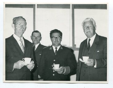
black and white photograph, January 1974
This photograph was published in "The News" on Friday, January 11 1974. Those in the photograph are : L -R Stan Reed, Ted Smith, Alf Barling and Major General Sir Rohan Delacombe (Governor of Victoria). They are having morning tea with the State Governor when he visited Orbost.The accompanying article was titled "TEA WITH THE GOVERNOR". Councillor S. J. Reed was the Orbost Shire President, E.A.Smith was a Shire Councillor and Mr A. Barling was the Orbost Municipal Band Leader. The first Orbost Brass Band was formed in 1889. Around 1908 the town band split and the Orbost Workers' Band was formed. Eventually the two bands merged in 1913 to reform as the Orbost Municipal Band under conductorship of Charles Spink. The band continued for many years but was later disbanded and again reformed. This was to happen a number of times, the last time being in 1961 and continuing through to the late 1970's. Further info and Ref: In Times Gone By - Deborah Hall This photograph is associated with the Orbost Municipal Band. The various Orbost bands over the years played a major role in community activities providing entertainment and musical experiences for the many members. Major General Sir Rohan Delacombe was the last British Governor of Victoria, Australia from 1963 to 1974.A black / white photograph of four men standing facing the camera. They are dressed in suits and wearing ties. One man is dressed in a band uniform. Three are holding cups and saucers.orbost-municipal-band barling-alf delacombe-rohan -
 Ringwood and District Historical Society
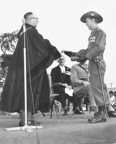
Photograph, Lt. Col Baldwin receiving Freedom of Ringwood City from the Mayor, Cr. B.J. Hubbard - 27 March, 1965. ( 2 photographs)
Typed on back of one photograph, 'Lt. Col Baldwin receiving the key and the certificate of Freedom from the Mayor. Town Clerk, F. Dwerryhouse seated at back. The unit paraded on the reserve at the back of the Town Hall. 27 Mar. 1965'. Written on back of another picture, "Mayor Ben Hubbard handing "Freedom of City" to Capt.. 3rd Div. Engineers'. Last photograph states below it, 'Freedom of the City' on back of same picture, '27th Mar. 65. Mayor (Cr. B.J. Hubbard presenting scroll of Freedom of City to Royal Australian Engineers'. Typed below 11172-2: 1965 Mayor Cr. B. Hubbard presenting scroll qwith Major General His Honour Norman A. Vickery & Major Gen R. J. H. Risson, and handwritten on the reverse: "This is the Scroll presented to the Royal Australian Engineers 3rd Division on 27 March (1965) granting them the freedom of the City of Ringwood. From Left the Mayor of Ringwood (Cr Benjamin Hubbard), The Commander 3rd Division (Major General His Honour Judge Norman A. Vickery) and Major General RJH Risson who represented the Colonel Commandant, Royal Australian Engineers" -
 Ringwood and District Historical Society
Photograph, John Gallagher Photography, Ringwood Philatelic Society meeting in supper room Ringwood Town Hall, 7th August, 1953 (2 Photos)
2 copies of Black and White Photograph . VC1634-1 is the fill photo, VC1634-2 is a slightly cropped imageWritten on backing sheet of VC1634-1: "Ringwood Philatelic Society meeting in supper room Ringwood Town Hall, 7th August, 1953. L. to R. Mr. & Mrs. Wenn, J.K. McCaskill (Glasses), Stan Griffiths, K. Wellington, Paddy Miles, Phil Duerdoth, Edith McEwin".