Showing 132 items
matching united signs
-
 Bendigo Historical Society Inc.
Newspaper - AUSTIN COLLECTION: Koch's Pioneer Gold Mine, Long Gully
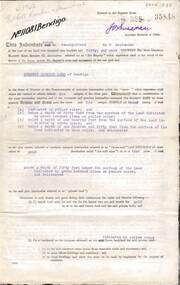
Koch's Pioneer Quartz Mining and Crushing Company was officially registered on June 30th., 1871 (Government Gazette No. 45, 1871). It operated at Long Gully, the first Manager was Andrew Lewis. Nominal capital was 90,000 pounds in thirty thousand shares of 3 pounds each. The initial partnership in a quartz crushing plant between Henry Koch, Simon Albert and Charles Wallin was dissolved in 1860 with Koch becoming the sole owner. In 1866 the crushing plant consisted of a 50 hp engine and 48 stamping heads capable of crushing 600 tons of quartz per week. By 1902 there were 72 stamps and this was by far the largest crushing plant in the area, serving many quartz mines. Henry Koch (1800-1889) was a German sailor who signed off when his ship reached Melbourne in 1851. Having heard of the gold discovery he proceeded to Bendigo where he was initially employed in puddling in the Myers Flat area. He was soon employed and then made partner in a quartz crushing plant that he became sole owner of in 1860. He was also landlord at the British and American Hotel and the Silver Mines Hotel. HE also started the Perseverance United gold claim. He married Anna Maria Theresia Heinz in 1857. In 1872 he sold the crushing plant for 75,000 pounds and took his family back to Germany. He resumed his trade as a ship builder although he maintained many Bendigo mining interests.Two sepia coloured images on paper, possibly taken from book. Top image: Koch's 'Pioneer' Quartz Crushing Works - Long Gully, printed under image. Image shows mining dam in foreground, large two storey mine building in middle background, two mine chimney on right hand side. Bottom image; interior of crushing battery. Printed on bottom ' Quartz Crushing Batteries & etc. Koch's Pioneer'. gold mining, koch's pioneer crushing battery, long gully, perseverance g.m. co., henry koch -
 Bendigo Historical Society Inc.
Document - INDENTURE, GOLD MINING LEASE 11081 CROWN AND HERBERT JACKSON LEED OF BENDIGO, MCCOLL, RANKIN AND STANISTREET COLLECTION, 21st September, 1940
Six page document plus map, dated 21st September 1940, between the Crown and Herbert Jackson Leed, for the land shown on the accompanying map 'indicated by yellow colour' Depths indicated on lease document. On map: Mining District of Bendigo, County of Bendigo, Parish of Sandhurst. No. 11081. Net Area 24 acres, 3 roods, 3 perches. Signed by Herbert Leed and ?Walsh, Warden Clerk, Bendigo. Map shows lease holding 11081 coloured yellow. Other leases: no's. 9882 11081, 11034, 11080. Streets: Fletcher Street, and Belle Vue Road. Gullies: Derwenters Mistake Bully and Pig Face Gully on lease 11081. Quarry Hill Recreation Reserve marked and some residential allotments. Water race indicated on map. On back of document: ; Deborah United Gold Mining Company No Liability of Charing Cross Bendigo is now the proprietor of the within described estate by transfer registered on 21st November 1940 and numbered 1795202.bendigo, mining, deborah united gold mine, herbert jackson leed, deborah united gold mining. major general sir winston joseph dugan -
 National Vietnam Veterans Museum (NVVM)
Certificate - Honorary Certificate USS New Jersey
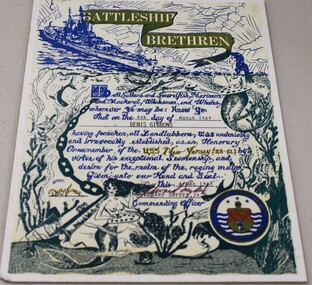
This certificate was awarded to news photographer Denis Gibbons to mark his time on USS New Jersey BB62. Gibbons spent 5 years in Vietnam, and photographed the tours of nine Australian infantry battalions for Fairfax press and United Press International. This is a non-official certificate signed by the commanding officer Edward Snyder Jnr.Paper with hard cardboard backing of under water scene-white with blue and gold writing. Banner heading in gold writing. Picture of a battleship top LHS, mermaids x2 holding a painters pallet, Anchor with chain. Emblem of battleship bottom RHS. Swordfish and sharks depicted.Battleship Brethren heading. USS New Jersey BB 62 Firepower for Freedom. Denis Gibbonsdenis gibbons, battleship brethren, march 1969, crewmember certificate, uss new jersey, gibbons, honorary certificate, us navy -
 Bendigo Historical Society Inc.
Map - COMET MINE - PLAN OF COMET MINE
Plan of the Comet Mine on the Hustler's Line of Reefs Bulletin No 33, Plate No XXIII. Map shows depths, Lightning Hill Anticline, Hustler's Anticline and approximate Lease Boundary. Signed by H. S. Whitelaw, Underground Survey Office Bendigo, September 1913. United Hustler's & Redan Co and Hustler's Reef Co also named on map. Geological Survey of Victoriamining, hustler's line of reefs, comet line plan belletin no 33 plate no xxiii, lightning hill anticline, hustler's anticline, united hustler's & redan co, hustler's reef co, h s whitelaw -
 Bendigo Historical Society Inc.
Map - HUSTLERS LINE OF REEFS - LONGITUDINAL SECTION THROUGH THE SADDLE REEFS
Drawing with Longitudinal Section through the Saddle Reefs along portion of Hustler's Line of Reefs, Bendigo. Map shows the depth of the mines, reef numbers and Datum 700 ft above sea level. North and South is also noted on the map. Map signed by H. S, Whitelaw, Underground Survey Office, Bendigo, September 1913. Bulletin No 33, Plate No XXXIV. Bendigo Creek, Ironbark Creek and Long Gully are also noted. Mines are: Fortuna Hustlers, Hustler's Royal Reserve No 2 Main Shaft, Hustler's Royal Reserve No 2 Park Shaft, Royal Hustler's, Imperial Hustler's, Extended Hustler's Freehold, Great Extended Hustler's Tribute (Pups), Old Shaft, Great Extended Hustler's Reef No 2, Great Extended Hustler's Main Shaft, Old Shaft, Hustler's Reef, Hustler's Reef No 1, Comet, K. K., United Hustler's & Redan, Old Shaft and Hustler's Consols. Has Geological Survey of Victoria Crest and underneath is: H. Herman, Director, W. Dickson, Secretary for Mines, The Hon. J Drysdale Brown M L C. Minister of Mines.Geological Survey of Victoria Crestmining, hustler's reef maps, hustlers line of reefs, bendigo creek, royal hustler's, imperial hustler's, extended hustler's freehold, great extended hustler's tribute (pups), great extended hustler's reef no 2, great extended hustler's main shaft, hustler's reef, hustler's reef no 1, united hustler's & redan, old shaft and hustler's consols.h s whitelaw, underground survey office bendigo september 1913 -
 Bendigo Historical Society Inc.
Map - UNITED HUSTLER'S & REDAN & K. K. MINES - PLAN OF THE UNITED HUSTLER'S & REDAN & K. K. MINES
Plan of the United Hustler's & Redan & K. K. Mines Bulletin No 33 Plate No XXXI. Shows depth of levels, Probable positions of reefs and natural surface with the poppet legs at the two shafts. Sill of shaft of the K. K. Mine 773.56 ft above Sea Level and sill of shaft of the United Hustler's & Redan Mine 745.62 above Sea Level. Also mentioned is the average amount of gold obtained per ton. Note on the top of page - Plates 4, 8, 13, 20, 26 & 31 form a Longitudinal Section from Fortuna Hustler's to Hustler's Consols Mine. Geological Survey of Victoria emblem and signed by H S Whitelaw, Underground Survey Office, Bendigo, September 1913. mining, parish map, united hustler's & redan & k. k. mines, geological survey of victoria, h s whitelaw, underground survey office bendigo -
 Bendigo Historical Society Inc.
Map - UNITED HUSTLER'S & REDAN & K. K. MINES - PLAN OF UNITED HUSTLER'S & REDAN & K. K. MINES
Plan of the United Hustler's & Redan & K. K. Mines on the Hustler's Line of Reefs Bulletin No 33 Plate No XXVII. Plan shows depth of levels, Long Gully, Hustler's Line of Reefs, Lightning Hill Line of Reefs and approximate Boundary of Lease. Also mentions Comet Co. Geological Survey of Victoria emblem and signed by H S Whitelaw, Underground Survey Office Bendigo September 1913.mining, parish map, united hustler's & redan & k. k. mines, long gully, hustler's line of reefs, lightning hill line of reefs, comet co, h s whitelaw, geological survey of victoria, underground survey office -
 Bendigo Historical Society Inc.
Map - UNITED HUSTLER'S & REDAN & K. K. MINES - PLAN OF UNITED HUSTLER'S & REDAN & K. K. MINES
Plan of the United Hustler's & Redan & K. K. Mines on the Hustler's Line of Reefs Bulletin No 33 Plate No XXVIII. Plan shows depth of levels, stone encountered and some geological features. Geological Survey of Victoria emblem and signed by H S Whitelaw, Underground Survey Office Bendigo, September 1913. mining, parish map, united hustler's & redan & k. k. mines, united hustler's and redan shaft, k. k. shaft, h s whitelaw -
 Bendigo Historical Society Inc.
Map - UNITED HUSTLER'S & REDAN MINE - TRANSVERSE SECTION UNITED HUSTLER'S & REDAN MINE
Transverse Section of the United Hustler's & Redan Mine on the Hustler's Line of Reefs Bulletin No 33, Plate No XXIX. Map has drawing of poppet legs on the surface, depth of levels, type of stone encountered and some geological features. Sill of shaft 745.62 ft above sea level. Map has Geological Survey of Victoria emblem and signed by H S Whitelaw, Underground Survey Office Bendigo, 'September 1913. mining, parish map, united hustler's & redan mine, hustler's line of reef, geological survey of victoria, h s whitelaw -
 Bendigo Historical Society Inc.
Map - UNITED HUSTLER'S & REDAN MINE - TRANSVERSE SECTIONS N & S OF SHAFT UNITED HUSTLER'S & REDAN MINE
Transverse Sections N & S of Shaft United Hustler's & Redan Mine on the Hustler's Line of Reef Bulletin No 33, Plate No XXX. Map shows some of the stone encountered on the levels and depth. Geological Survey of Victoria emblem and signed by H A Whitdan, Underground Survey Office Bendigo, September 1913.mining, parish map, united hustler's & redan mine, transverse sections n & s of shaft united hustler's & redan mine, hustler's line of reef -
 Bendigo Historical Society Inc.
Document - KOCH'S PIONEER QUARTZ MINING AND CRUSHING COMPANY, NO LIABILITY - SHARE CERTIFICATE
Koch's Pioneer Quartz Mining and Crushing Company, No Liability Long Gully Bendigo Share Certificate. Distinctive Numbers 48164 to 48213 in the name of William Grattan of St Kilda. Certificate Number 2930. Dated 7th December 1911. Signed by ?, Hugh Boyd, Directors and J. H. Craig, Manager. On the back is a map of the lease showing where the shaft is and a measurement of 450 yards from one side of the lease to the other beside the shaft. The lease is an irregular shape. Adjoining leases mentioned are Windmill Hill Co., G. Lansell's Sandhurst Mine, Cornish United Co. and the Hercules & Energetic Co. Arthur T. Walker, M. S. printed at the bottom. Albert Richardson Collectionmining, parish map, koch's pioneer, koch's pioneer quartz mining and crushing company, no liability, koch's pioneer quartz mining and crushing company, no liability share certificate, william grattan, hugh boyd, j h craig, arthur t walker, windmill hill co., g lansell's sandhurst mine, cornish united co., hercules & energetic co. -
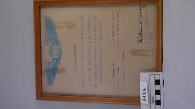 National Vietnam Veterans Museum (NVVM)
Certificate - Certificate from United States Air Force, 8th December 1967
Signed by William W Momyer.Lt General USAF Commander.Lt. John Methven. Date- 8th December 1967. Type-A/C F - 100 D. F.A.C. Report - Smoliage. Pilot - Captain Garry B Tompkins. Target - VC Position and bunkers. Certificate (original ) From United States Air Force. Stating 1st. Lt. John Methven 37604 has flown in combat with US. Forces over Vietnam. The certificate is in a light timber frame.Certificate (original ) From United States Air Force. Stating 1st. Lt. John Methven 37604 has flown in combat with US. Forces over Vietnam. The certificate is in a light timber frame.Signed by William W Momyer.Lt General USAF Commander.Lt. John Methven. Date- 8th December 1967. Type-A/C F - 100 D. F.A.C. Report - Smoliage. Pilot - Captain Garry B Tompkins. Target - VC Position and bunkers.certificate - usa, lt gen william w momyer, usaf commander, lt john methven, john methven, capt garry b tompkins, united states air force, 37604, royal australian infantry corps, 7th battalion, the royal australian regiment