Showing 543 items
matching vegetation
-
 Orbost & District Historical Society
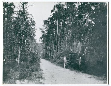
black and white photograph, 1913
This photograph shows the regrowth of vegetation on the road between Genoa and the border - now the Princes Highway.This is a pictorial record of the main road from Orbost to the New South border, The Princes Highway, in the early 20th century.A large black / white photograph of a bush road wwith a vehicle and a man on the side of it.on back - " Princes Highway showing the regrowth.....1913"princes-highway-genoa transport -
 Ballarat Heritage Services
Book, Hepburn Shire Council Biodiversity strategy, 2018, 2018
48 Page report on biodiversity in the Victorian Shire of Hepburn. non-fictionbiodiversity, shire of hepburn, ricky nelson, dja dja wurrung, public land management, climate change, habitat corridors, biolink zones, weed management -
 Lakes Entrance Regional Historical Society (operating as Lakes Entrance History Centre & Museum)
Photograph, 1990 c
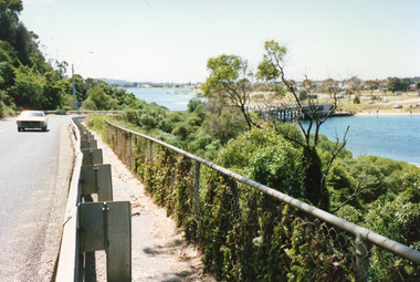
One other photograph showing vegetation taken from the left hand side of road.Colour photograph taken from the Princes Highway, showing the last bend in the road before the northern approach to the concrete North Arm Bridge, shows the North Arm and waterfront in distance. Lakes Entrance Victoriaconstruction, bridges -
Lakes Entrance Regional Historical Society (operating as Lakes Entrance History Centre & Museum)
Postcard, Rose Series, 1925 c
Post and rail fence beside highway and no vegetation on sand dunes eastern part of Cunninghame ArmBlack and white postcard showing view of Cunninghame Arm from Jemmys Point, gravel Princes Highway, North Arm bridge and end of town Lakes Entrance VictoriaNearing Lakes Entrance on the Princes Highwaytownship, waterways -
 Emerald Museum & Nobelius Heritage Park
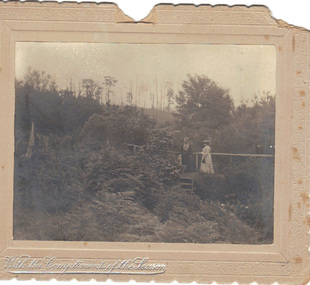
B/W Photograph, December 1904
The card was probably sent as a Christmas gift to an unknown recipient by "H & GB", presumably a married couple. The two women in the photo might be known to sender and receiver, or might even be the receivers. The scene is suspected to be in the grounds of the Country Club at Emerald, Victoria.As the card is clearly dated, and the figures clearly named, it is a record of people resident in Emerald. From it we can make out some details of their dress and the physical surroundings of the time.B/W photograph mounted on embossed cardboard with crimped edges. It depicts two women standing on a small bridge over a creek in dense vegetation. There are trees in the background and ferns in the foreground. Front bottom left: silver embossed "With the Compliments of the Season" Rear: Handwritten "Mrs Airey & Miss Doolan on Bridge over Creek From ?H & ?GB 18?/12/1904" At bottom: "May be Country Club"airey, doolan, creek, country club, 1904 -
 Bendigo Historical Society Inc.
Photograph - BUICK COLLECTION: PHOTOGRAPH OF 'THE GRANGE', BIG HILL
Photograph of 'The Grange' , Big Hill . Inscription: 'Showing entrance gates in foreground'. Phot shows mostly vegetation and topography (Big Hill??) and little detail of home in distance with surrounding trees.person, family, buick family collection -
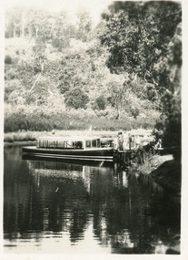 Lakes Entrance Regional Historical Society (operating as Lakes Entrance History Centre & Museum)
Photograph, Bulmers Studio, 1940c
Two copies purchased, One black and white enlargement 25 x 18.5 cm, 1 x sepia print 15 x 10 cmBlack and white small format postcard showing launch, M V Blackbird at Comers North Arm Jetty. Thick vegetation on bank, people on jetty. Lakes Entrance Victoriajetties, waterways, boats and boating, tourism -
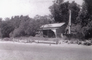 Lakes Entrance Regional Historical Society (operating as Lakes Entrance History Centre & Museum)
Photograph, 1910c
Black and white photograph showing cottage, The Beacons, on dune, beacon pole to right of cottage, trees and vegetation on dune, logs along beachfront to stop erosion. Lakes Entrance Victoriahouses, jetties, waterfront -
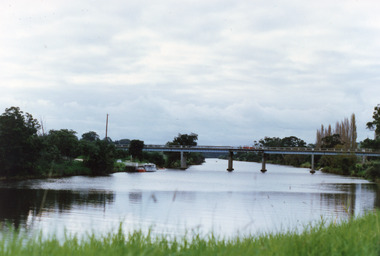 Lakes Entrance Regional Historical Society (operating as Lakes Entrance History Centre & Museum)
Photograph, 1990
Colour photograph showing view of the Tambo River at Swan Reach looking upstream. Boats at jetty on left, vegetation on each bank, poplar trees on right. Swan Reach Victoriabridges -
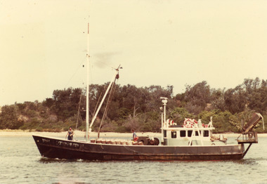 Lakes Entrance Regional Historical Society (operating as Lakes Entrance History Centre & Museum)
Photograph, 1980
Colour photograph of the scallop fishing boat Southern Hunter in Cunninghame Arm, showing two people on deck and stacked bags of scallops, vegetation on hummocks in background. Lakes Entrance Victoriaboats and boating, fishing industry, islands, fish -
Lakes Entrance Regional Historical Society (operating as Lakes Entrance History Centre & Museum)
Postcard, Victoria Railways, 1905c
Also a tinted postcard titled Lake Tyers Victoria Railways Tourist Series number 03821.1 size 9 x 13.x cm purchased from B RoacheTinted postcard of Lotos Bay Nowa Nowa showing an open waterway surrounded by thick natural vegetation, rowing boat containing two people on lake. Lake Tyers VictoriaLotos Bay Nowa Nowa Lake Tyersforest, waterways -
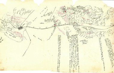 Beechworth Honey Archive
Hand-Drawn Map Centred on Ararat by Frank Lebbell Frost December 1916
This is one of the maps drawn by Frank L. Frost while he was beekeeping in North-East Victoria. This particular map may be reference in the "Wooden" Diary on page 11. Front Side: Hand-drawn map centred on Ararat, central Victoria. Details road and railway and vegetation with comments on flowering. Back Side: Comments in grey lead [ca 1923]hand drawn, hand-drawn, map, ararat, frost, beekeeper, beechworth honey -
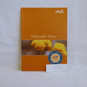 Greensborough Historical Society
Book, Nillumbik Shire Council, Live local Plant local: Nillumbik Shire, 2001_
Nillumbik Shire is known for its natural vegetation. This text encourages locals to plant indigenous plants in their gardens.A guide to indigenous vegetation in the Nillumbik Shire.56 pages, illus. (some col.). Cover has yelloe flowers in band on orange background with shire logo.nillumbik shire council, environmental and cultural planning section, chris delaney, indigenous plants, native gardens -
Federation University Historical Collection
Book, Land COnservation Victoria, Land Conservation Council Victoria Report of the North Eastern Area (district 1), 1972, 1972
Yellow and brown soft covered book with brown tapespine. Includes land use, recreation, agriculture, apiculture, vegetation, birds, water physiography, geology, climate, soils, fauna, land systems. Block descriptions include Bethanga, granya, Lawson, Walwa,Pine Mountain, Mittamatite, Elliot, Bunroy, Wabba, Mount Cadgewa, ucyvale, Koetan, Burrowa. Black and white images include Mitta Mitta arm, Corryong, Tallangatta, Lake Hume, Aboriginal rock shelter at Mount Porcupine, Koetong uplands, Mitta Mitta massif, bandicoot, wombat, skink, Flaggy Creek plateau, Walwa, Murray Cod, Thowgla, emu, grasstree, land conservation, north-eastern victoria, environment, landuse, recreation, timber, apiculture, water, upper murray, vegetation, birds -
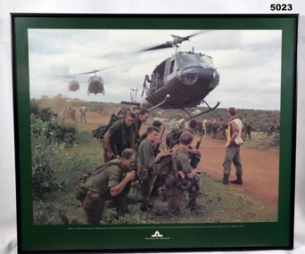 Bendigo Military Museum
Print - PRINT, FRAMED
Caption under print. Soldiers of 5 Platoon, B Company, 7 RAR, preparing to board VS Iroquois helicopters during operation Ulmarrah, the cordon and search of Lang Phuoc Hai Village, South Vietnam, 26 August 1967". Members of 5 Platoon, B Company, 7th Battalion, The Royal Australian Regiment (7RAR), just north of the village of Lang Phuoc Hai, beside Route 44 leading to Dat Do. United States Army Iroquois helicopters are landing to take them back to Nui Dat after completion of Operation Ulmarra, the cordon-and-search by 7RAR of the coastal village of Lang Phuoc Hai. Operation Ulmarra was conducted by 2nd Battalion, The Royal Australian Regiment (2RAR) and 7RAR with support elements. Left to right: Private (Pte) Peter Capp (kneeling); Pte Bob Fennell (leaning over, facing camera, with an ammunition belt for an M60 machine gun slung over his shoulder); Corporal Bob D'Arcy (partly obscured behind Fennell); Pte Neal Hasted (centre, front); Pte Ian Jury (partly obscured, centre, rear, holding rifle); Pte Colin Barnett (front, right, M60 ammunition belt on back, back of head to camera); Lance Corporal Stan Whitford (partly obscured behind Barnett); the helicopter marshal at right is Pte John Raymond Gould, 7RAR. The United States Army Iroquois UH-1D helicopter was operated by 2 Platoon, 162nd Assault Helicopter Company, 11th Combat Aviation Battalion. (Having achieved almost the status of an icon, this image was chosen for, and is etched on, the Australian Vietnam Forces National Memorial on Anzac Parade, Canberra, ACT, dedicated in October 1992). Source AWM Print donated and dedicated to 3789179 FRANK FRIGERIO, 5 Platoon, B Company, 7RAR. See also Cat No. 3543-3549.3Print - coloured print of a photograph depicting three helicopters coming in to land above a dirt road with several groups of soldiers in uniform with jungle vegetation in the background. Frame - black painted metal.See in context, historical - caption under print.prints, framed, accessories, vietnam war -
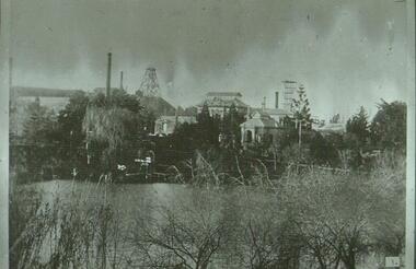 Bendigo Historical Society Inc.
Slide - ALBERT RICHARDSON COLLECTION :OLD CHUM MINE ON NEW CHUM HILL
Slide. Old Chum Mine on New Chum Hill, image taken from rear of lake at Lansell's 'Fortuna' Villa. Mine buildings and poppet head in background, lake and vegetation in foreground.No. 3 on bottom of slidemine, gold, fortuna & old chum mine, bendigo mines-jack hattam collection -
 Lakes Entrance Regional Historical Society (operating as Lakes Entrance History Centre & Museum)
Postcard, Bulmers Studio, 1940c
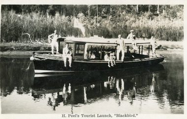
Four black and white small format postcards 6 x 8.5cm, slightly different view of the boat coming down the waterway.Black and white postcard showing Peels launch Blackbird in North Arm. Five men posing outside, three children sitting in the side. Thick vegetation on bank. Lakes Entrance VictoriaH. Peel's Tourist Launch, 'Blackbird'waterways, restaurant, boats and boating, tourism -
 Lakes Entrance Regional Historical Society (operating as Lakes Entrance History Centre & Museum)
Photograph, 1880c
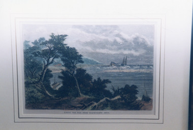
Taking the Bar, 1876 woodcut of original entrance, with paddle steamer 'Lady of the Lake' and pilot boat grinding through rough conditions, can see Roadknight's Jetty, they lived at Merrangbaur, is aboriginal for home of lyrebirds.Colour photograph of a painting of a ship being towed over the natural entrance to the Gippsland Lakes. Red Bluff in background, Roadknight Jetty glimpsed through the natural vegetation. Lakes Entrance VictoriaTaking the Bar from Roadknights Jettyjetties, public works -
 Greensborough Historical Society
Slide - Photograph, John Ramsdale, Plenty River with European trees: Slide 27, 1990s
Photograph shows the Plenty River at Greensborough with European trees on the bank.Part of the John Ramsdale collection of slides and audio visual material.Colour photograph scanned from slide.No caption. Printed maker's mark on slide "Kodak Kodachrome Slide"plenty river, vegetation -
 Greensborough Historical Society
Slide - Photograph, John Ramsdale, Plenty River with European trees: Slide 24, 1990s
Photograph shows a section of the Plenty River with European trees and clay run-off from building nearby.Part of the John Ramsdale collection of slides and audio visual material.Colour photograph scanned from slide.No maker's marks. No caption on slide.plenty river, vegetation -
Lakes Entrance Regional Historical Society (operating as Lakes Entrance History Centre & Museum)
Book, Willis J H, Botanical Pioneers in Victoria, 1949
A booklet reprinted from the victorian Naturalist, Vol 66 parts 5,6,7, short biographies of botanical pioneers Robert Brown, Allan Cunningham, Ronald Gunn, Thomas Mitchell, James Backhouse, Ferinand Von Mueller, A J Ewart and 38 specialist pioneers includvegetation, settlers -
Lakes Entrance Regional Historical Society (operating as Lakes Entrance History Centre & Museum)
Book, East Gippsland Shire Council, Roadside Management Plan Part A Policy & Background, 2003
Fire Prevention stategy identifying plans to decrease the vulnerability of people and property in the shire with uncontrolled fires East Gippsland Victoriafire brigade, vegetation -
Lakes Entrance Regional Historical Society (operating as Lakes Entrance History Centre & Museum)
Book, Paul Kelly & Associates, East Gippsland Community Wellbeing Plan 2005-2008, 2003
Code of practice detailing minimum acceptable standards of work on land managed , works includes construction works regular maintenance contractors and provision of services East Gippland Victoriavegetation, fire brigade -
Lakes Entrance Regional Historical Society (operating as Lakes Entrance History Centre & Museum)
Book, Department of Conservation and Environment, Wilderness Special Investigation Final Recommendations, 1991
An approved management plan relating to the public foreshore land between Lake Bunga and Mill Point. Contains plans and appendices.waterfront, vegetation -
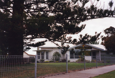 Lakes Entrance Regional Historical Society (operating as Lakes Entrance History Centre & Museum)
Photograph, 1999
House built 1926 for Rex and Mac HarbeckColour photograph of the office of East Sanders Pty Ltd Accountants, at 12 Roadknight Street, shows as original residence converted to office, a very large Norfolk Island pine tree in left foreground of garden. Lakes Entrance Victoriavegetation, houses -
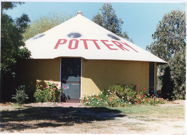 Lakes Entrance Regional Historical Society (operating as Lakes Entrance History Centre & Museum)
Photograph, 1994 c
Also second identical copyColour photograph of one of the circular buildings at the pottery at Swan Reach, Victoria.vegetation, farm driveway -
 Lakes Entrance Regional Historical Society (operating as Lakes Entrance History Centre & Museum)
Photograph, Tambo Shire, 1994 c
Also second identical copyColour photograph of grazing country near Buchan, showing cattle on grassy flat rugged rocky hill in background. Buchan Victoriavegetation, primary industry -
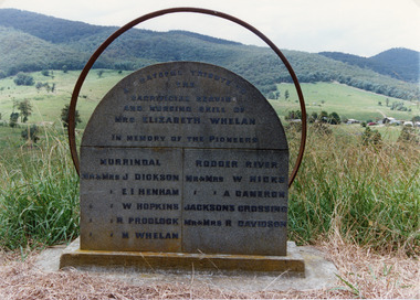 Lakes Entrance Regional Historical Society (operating as Lakes Entrance History Centre & Museum)
Photograph, Tambo Shire, 1994 c
Also second identical copyColour photograph of the roadside Pioneer Memorial at Murrindal near Buchan, Victoria.topography, vegetation -
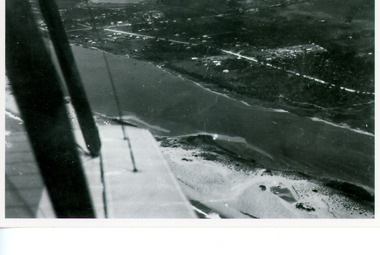 Lakes Entrance Regional Historical Society (operating as Lakes Entrance History Centre & Museum)
Photograph, Bulmer H D, 1940c
Black and white copy photograph of aerial view of eastern approach, showing Princes Highway, Whiter's Camp Park, sandy outer barrier beside Cunninghame Arm, distant view of North Arm. Lakes Entrance Victoriawaterways, vegetation -
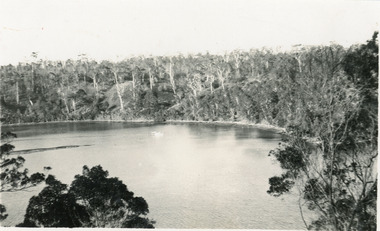 Lakes Entrance Regional Historical Society (operating as Lakes Entrance History Centre & Museum)
Photograph, 1924c
Black and white photograph of part of the North Arm. It shows the calm waters beneath steep heavily wooded banks. Some dead trees appear to have been ring barked. Lakes Entrance Victoriavegetation, tourism