Showing 170 items
matching walkways
-
 Kew Historical Society Inc
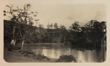
Photograph, Outer Circle Railway Bridge over River Yarra, c.1900
This photograph forms part of the Eric Sibly collection of images and information relating to the Outer Circle Railway which he donated to the Kew Historical Society in 1974. Heritage Victoria Citation (Abridged) "The Chandler Highway Bridge, a 137 metre wrought iron lattice-truss girder bridge with four spans supported on red brick piers with moulded bluestone cappings. The bridge has a cantilevered walkway along the west side. ...The Chandler Highway Bridge crosses the Yarra River and connects Alphington and Kew. It was completed in November 1890 as part of the Outer Circle Railway Line.Black & white photograph of the railway viaduct over Yarra River looking south towards Kew.Reverse: "Pre 1930. Outer Circle Railway Bridge over River Yarra (now Chandler Highway) - note bridge over line on Kew side for Asylum Farm". KH - 56. Kew Historical Society.chandler highway, railway bridges - kew (vic), sir john monash, outer circle railway, river yarra - kew (vic) -
 Bendigo Historical Society Inc.
Photograph - UNKNOWN MINING PHOTOS - POPPET LEGS & BUILDINGS
Black & white photocopy of a photo of the poppet legs, a corrugated iron building, a wood stack, and a frame structure. A man is on the walkway going toward the landing brace. (b) Picture of woden poppet legs, corrugated iron building, tramway and a large mullock heap. (c) Photocopy of wooden poppet legs with stairway going up to the landing, corrugated building, a tank beside the building, ore bins with a man and horse and dray beside them. In the background are houses.photo, unknown mining photos, poppet legs & buildings -
 Mt Dandenong & District Historical Society Inc.
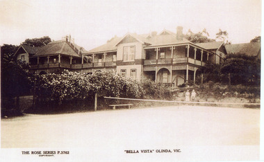
Photograph, "Bella Vista" Olinda, c1940
Copy of Rose Series Postcard number 3762Copy of Rose Series Postcard #3762 showing Bella Vista Guest House at Olinda. This image is c1940s and shows the tennis court in the foreground. Bella Vista was built by Edmund Boulter in 1903. It comprised two large buildings with a walkway linking the balconies at second storey level. Views of Westernport and Port Phillip Bays could be seen from the rooftop lookout. Bella Vista was reputed to accommodate eighty guests. The Guest House operated until 1956, when it burned down.bella vista, guest house, tennis, boulter, rose series -
 Sunbury Family History and Heritage Society Inc.
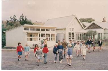
Photograph, Bulla Primary School, 1964
The school in the photograph is Bulla State School No. 46 and was originally known as the Government -funded Bulla Common School, built 1870 - 1871. With the passing of the Education Act in Victoria in 1873 it became known as Bulla State School No. 46. The original building comprised of a rectangular shaped bluestone building with a 3 roomed residence attached. As school enrolments began to increase in the district, a weatherboard classroom was added in 1881 and later extended in 1927 adjacent to the original building with a covered walkway between the two buildings. The modern portable classroom was added in the 1960s. Bulla Primary School closed in 1996 after much local controversy. The property is now privately owned. The photograph was taken in 1964.The bluestone section of the school with residence is one of very few remaining in the state and is of local heritage classification in the City of Hume.A non-digital coloured photograph of children in a school playground with the buildings visible in the background.bulla state school no. 46, school lane, bulla, education act 1873, common schools -
 Bendigo Historical Society Inc.
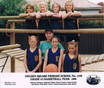
Photograph - GOLDEN SQUARE LAUREL STREET P.S. COLLECTION: PHOTOGRAPH - GSPS GRADE 4/5 BASKETBALL TEAM 1996
Coloured photograph of the Goden Square Primary School No. 1189 Grade 4/5 Basketball Team, 1996. Photo taken at a piece of wooden playground equiment. The girls in the back row are standing on a wooden walkway and the other row are standing in front of them. Their names are:- Back Row, L to R: Bethany Thompson, Raphaella Walker, Emma Tremain, Naomi Doolan. Front Row, L to R: Kim Martin, Trish Kline (Coach), Gemma Ruschmeyer, Kylie Martin. Oval sketch of the school on the right of the names.education, primary, golden square laurel st p.s., golden square laurel street p.s. collection - photograph - gsps grade 4/5 basketball team, 1996, bethany thompson, raphaella walker, emma tremain, naomi doolan, kim martin, trish kline (coach), gemma ruschmeyer, kylie martin -
 Bendigo Historical Society Inc.
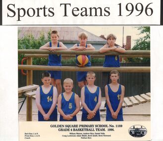
Photograph - GOLDEN SQUARE LAUREL STREET P.S. COLLECTION: PHOTOGRAPH - GRADE 6 BASKETBALL TEAM 1996
Coloured photograph of the Goden Square Primary School No. 1189 Grade 6 Basketball Team, 1996. Photo taken at a piece of wooden playground equiment. The boys in the back row are standing on a wooden walkway and the other boys are standing in front of them. Their names are:- Back Row, L to R: William Watson, Andrew Rice, Daniel Vella. Front Row, L to R: Craig Lockwood, Adam Walsh, Brett Smith, Brett Neiwand. Coach: Nathan Rice. Oval sketch of the school on the right of the names.education, primary, golden square laurel st p.s., golden square laurel street p.s. collection - photograph - gsps no. 1189 grade 6 basketball team 1996, william watson, andrew rice, daniel vella, craig lockwood, adam walsh, brett smith, brett neiwand, nathan rice -
Federation University Historical Collection
Document - Report, University of Ballarat Canadian Wetlands Project Report, 2000, 04/2000
1992 - Property purchased fronting Geelong Road, Mount Helen 1994 - Additional adjoining property purchased 1995 - Wetlands included in the Corporate Plan for the area 1997 - Launch of Wetlands Development by Minister Maclennan 1998 - Preliminary planning and plant identification underway - Contract signed for funding 1999 - Stage 1; Planning finalised, earthworks undertaken and weed infestation assaulted - "Work for the Dole" project undertaken - Deluge of rain on Boxing Day provides the centrepiece f the project, the just-completed dam, with a body of water to overflowing level. - Waterbirds move in and the germination of native wetland plant species begins 2000 - Stage 2 plans developed, including additional walkways, bird hides and interpretation. Three page report on the University of Ballarat Canadian Wetlands Project. Direct funding for the project was provided by the University of Ballarat; The Department of Employment, Workplace Relations and Small Business and the Corangamite Catchment Authority.ballarat technology park, canadian wetlands, ian howe, mount helen, mount helen campus -
 Federation University Historical Collection
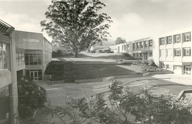
Photograph - Black and White, Mount Helen Campus, 1979
Five black and white images of the courtyard at the Mount Helen Campus of Federation University Australia. .1) View of the courtyard North of 'S' building, towards east .2) View westward, across the courtyard pool (since demolished). The walkway joins the library building (right) and 'S' building. .3) View towards the north-west. Coates Centre ('U' building, formerly Union Building) with Stage Two is on the right. The library is centre. To the left is 'S' building .4) View from the East end of Coates Centre ('U' building) towards 'E' building. -
 Nillumbik Shire Council
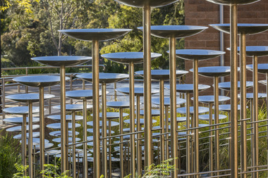
Public Art: Robert BAINES (b.1949, Melb, Aus), Robert Baines, Transaction (Location: entrance, Nillumbik Shire Council Offices, Civic Drive, Greensborough), 1994
The site specific sculpture is located at the entry to the office of Nillumbik Shire Council. It was commissioned in 1994 by the Shire of Diamond Valley for their 20 year celebration. Baines was chosen from a short list of three artists. He is an internationally renowned artist, particularly in the field of gold and silver smithing. 'Transaction' takes on the visual and aesthetic vocabulary of its surroundings. It is a statement of the geometry and idiosyncrasy of its immediate site. The series of arcs are reinterpreted into longitudinal curves in the sculpture. It is a transaction between the place and the anticipated entry to the building. The title also suggests the flow of civil and administrative procedures that take place daily within the Shire's offices. A large cascading form in stainless steel. Multiple rows of concave dishes set on long steel stems, which progressively increase in size as they rise in height. The work plays elaborately with perspective, and its repeated shapes are arranged in a orderly mathematical series. It faces a wheelchair ramp lined with polished steel rails, and is integrated with the architectural features of its forecourt setting, for which it was designed. The piece is sited in a small garden area and can be viewed from within the building's foyer. In bright sunlight, its dish-shapes cast elliptical shadows across walkways and lawns. N/Apublic art, transaction, ekphrasis2017, stainless steel, disks, poles, council -
 Ballarat Tramway Museum
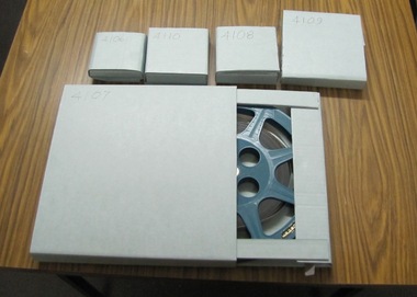
Film - Movie Film & Box, 1970s
Movie Film - 16mm on a black metal reel, 124mm diameter. Title, Carriages Interior Shots – Length 3:01 mins, colour, 16mm colour with sound. ( source not known at this time.) Time Sequence Description 0:00 Interior views of wooden rail carriages, Interior view of an air-conditioned cars including corridors, toilets, compartments, walkways and other materials. Signs, seats, people playing cards on a table. 3:01 end. Placed in a blue cardboard box specially made for the item 30/08/2010.trams, tramways, victorian railways -
 Kew Historical Society Inc
Photograph - Zig-Zag Bridge on the Yarra River at Kew, 1924
Henry Beater Christian (1886-1962) , was a descendant of one of the earliest settler families in Kew. Employed at the Kew Asylum as a 'public servant', he was a skilled amateur photographer, photographing numerous scenes in Kew and on his travels around Victoria. The majority of his photographs date from 1916 to 1929. His finest photographs are housed in two photograph albums. Digital copy of a photograph from page 8 of the 47-page photograph album containing 261 gelatinous silver images, loaned by Diane Washfold with permission given to digitise and hold a copy in our collection. The Zig-Zag Bridge linked the grounds of the Yarra Bend and Kew Asylums. The wooden bridge was constructed in the 1870s and lasted through numerous floods until its destruction in 1929. A horizontal structure, the walkway was reached via a wooden staircase on the Kew side. The steps were required due to the different levels of the banks on this stretch of the river. "Zig-Zag Bridge"henry beater christian (1886-1962), landscape photography, kew (vic.) — yarra river, christian-washfold collection, photograph albums, zig-zag bridge -
 Kiewa Valley Historical Society
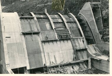
Photo - Junction Dam Construction, Circa 1940's
Junction (Lake Guy) Dam is a 'slab and buttress' type wall. A timber frame is built and then filled with concrete. The first batch of concrete was placed in September, 1940. By June, 1941 the buttresses were finished to a height safe from floods and in October of that year a flood of 2,800 cusecs occurred but with only slight damage to the installations. Industrial trouble caused some delays but there was also slow progress on the part of the contractor and the work was taken over by the S.E.C., terminating the contract. The dam was completed in March, 1944. A walkway was made through the dam wall. Lake Guy was named after Mr. L.T. Guy who was the Resident engineer, in charge of construction work and associated activities on the Kiewa Area from 1939 to November 1946Photos of the construction of the Junction Dam detail the harsh conditions faced by construction workers, building dams and villages to accommodate workers in the 1940s to the 1950s. Australia at this period in time, experienced a surge of population (influx of World War II refugees), which was the catalyst for developing and undergoing an enormous hydroelectricity program for the Alpine regions, both in Victoria and New South Wales. This program was initiated to supply electricity to the major southern Australian cities of Adelaide, Melbourne and Sydney. It was thought that these developments would reduce, if not eliminate, the requirement for coal driven power stations. However time has demonstrated that these power stations have not matched the demand required by the industries and the populations of the major urban and cities.Black and white photograph of Junction Dam constructionjunction dam, bogong, secv -
 Kiewa Valley Historical Society
Photo - Junction Dam Diversion Tunnel
Junction (Lake Guy) Dam is a 'slab and buttress' type wall. A timber frame is built and then filled with concrete. The first batch of concrete was placed in September, 1940. By June, 1941 the buttresses were finished to a height safe from floods and in October of that year a flood of 2,800 cusecs occurred but with only slight damage to the installations. Industrial trouble caused some delays but there was also slow progress on the part of the contractor and the work was taken over by the S.E.C., terminating the contract. The dam was completed in March, 1944. A walkway was made through the dam wall. Lake Guy was named after Mr. L.T. Guy who was the Resident engineer, in charge of construction work and associated activities on the Kiewa Area from 1939 to November 1946.Diversion dams are installed to raise the water level of a body of water to be redirected. The redirected water is used for hydro electric power generation. A diversion tunnel is usually bored through solid rock next to the dam site to bypass the dam construction site. The dam is built while the river flows through the diversion tunnel.Photos of the construction of the Junction Dam detail the harsh conditions faced by construction workers, building dams and villages to accommodate workers in the 1940s to the 1950s. Australia at this period in time, experienced a surge of population (influx of World War II refugees), which was the catalyst for developing and undergoing an enormous hydroelectricity program for the Alpine regions, both in Victoria and New South Wales. This program was initiated to supply electricity to the major southern Australian cities of Adelaide, Melbourne and Sydney. It was thought that these developments would reduce, if not eliminate, the requirement for coal driven power stations. However time has demonstrated that these power stations have not matched the demand required by the industries and the populations of the major urban and cities.Black and white photograph of Junction Dam diversion tunnel at Bogong VillageHandwritten on back - Junction Dam Diversional Tunnelbogong, secv, junction dam, lake guy -
 Kiewa Valley Historical Society
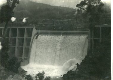
Photograph - Junction Dam spilling
Junction (Lake Guy) Dam is a 'slab and buttress' type wall. A timber frame is built and then filled with concrete. The first batch of concrete was placed in September, 1940. By June, 1941 the buttresses were finished to a height safe from floods and in October of that year a flood of 2,800 cusecs occurred but with only slight damage to the installations. Industrial trouble caused some delays but there was also slow progress on the part of the contractor and the work was taken over by the S.E.C., terminating the contract. The dam was completed in March, 1944. A walkway was made through the dam wall. Lake Guy was named after Mr. L.T. Guy who was the Resident engineer, in charge of construction work and associated activities on the Kiewa Area from 1939 to November 1946Photos of the construction of the Junction Dam detail the harsh conditions faced by construction workers, building dams and villages to accommodate workers in the 1940s to the 1950s. Australia at this period in time, experienced a surge of population (influx of World War II refugees), which was the catalyst for developing and undergoing an enormous hydroelectricity program for the Alpine regions, both in Victoria and New South Wales. This program was initiated to supply electricity to the major southern Australian cities of Adelaide, Melbourne and Sydney. It was thought that these developments would reduce, if not eliminate, the requirement for coal driven power stations. However time has demonstrated that these power stations have not matched the demand required by the industries and the populations of the major urban and cities.Black and white photograph of Junction Dam spilling at Bogong VillageHandwritten in pencil - Junction Dam spillingbogong, junction dam, lake guy, secv -
 Stawell Historical Society Inc
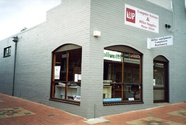
Photograph, WP Computer Systems
WP started by Gary Withers and David Phipps. A Computer Systems and Office Supplies Business at 139 Main Street. Later Moved to 107 Main Street beside Walkway and opened a second store in Barkly Street Ararat. 7200- WP Computer Systems 139 Main Street -1 to -4 Inside WP Computer Systems 139 Main Street Stawell -5 WP Computer Systems Barkly Street Ararat -6 WP Computer Systems Ararat with Gary Withers in Doorway -7 WP Computer Systems Ararat with Cheryl, Gary and visitor Robert Withers -8 WP Computer Systems inside the Ararat Shop -9 WP Computer Systems 107 Main Street Shop Grey Business WP Sign on cornerretail, business -
 Eltham District Historical Society Inc
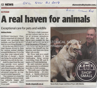
Document - Property Binder, 644 Main Road, Eltham
Newspaper advertisement: Leader Associated Newspapers, 100 Years of News Special Edition, August 27, 1997, p10; Veterinary Clinic Eltham Newspaper advertisement: Diamond Valley Leader, 2 December 2009, history, staff. Newspaper article: Diamond Valley Leader, 21 November 2018, about Eltham Veterinary Practice, photograph of Karly Cooper and Steve Pryor. Newspaper article: Diamond Valley Leader, 14 August 2019, residents of Eltham Gateway zone against Eltham Veterinary Practice's proposal for cattery. Newspaper article: Diamond Valley Leader, 2 December 2009, storm damage across Diamond Valley, photographs of Melissa Kingston and John Rose, Haddon Court, Eltham station walkway flooded.eltham, property, businesses, veterinary practices, haddon court eltham, eltham railway station, veterinary clinic eltham, main road eltham -
 Kiewa Valley Historical Society
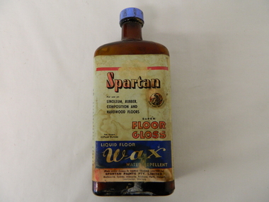
Bottle - Liquid Wax, mid 1900's
This bottle of liquid floor polish was manufactured before 1960(taken over by Wattyl) in a period when most of the floors in high traffic areas were covered in linoleum. Most of the floors using this product during this period would have been kitchens and laundries. During this period the cleanliness of the kitchen, hallways and eateries had to appear clean (cleanliness was a sign of a bacteria free area). This was a priority for kitchens, mess areas(SEC Hydro Scheme facilities) and connecting walkways. The cleanliness attitude was enhanced in the rural areas due to the "dirty" farm work not impinging upon the residential home.When Mount Beauty was first inhabited all the residential and worker's facilities were a prime area for linoleum floor surfaces. The liquid floor polish was in great demand, "a polished floor is a clean floor".This bottle of liquid floor polish is very significant to the Kiewa Valley, not only that it covers the floors of every home and residential barracks of the first major development of a "town" now known as Mount Beauty but also it demonstrates that the "cleanliness" approach of early Australians living areas in the rural regions was "on par" with its city cousins. It is the smaller types of mores that underlie the "mushrooming" cultural and psyche "wholeness" of an ever expanding Australian culture.This brown opaque glass bottle with an oblong shape has a blue coloured "screw on" cap. It has a "wrap around" label glued firmly on the bottle and covers the front and sides.On the front main label under a red line, "SPARTAN" underneath in smaller print "For use on" below this, "LINOLEUM, RUBBER, COMPOSITION AND HARDWOOD FLOORS" besides this is an encircled Trade Mark of a "Spartan Warrior holding a spear and shield" these word follow the curviture of the circle and are below it "TRADE MARK REGISTERED" Below this are "SUPER FLOOR GLOSS" to the left in very small print "Nett Contents 16 Fluid Ounces". Below this on a blue background and in white print"LIQUID FLOOR WAX WATER REPELLENT". On the bottom of the label "Made under licence by HARDIE TRADING LIMITED for SPARTAN PAINTS PTY, LIMITED" below this in small print "Melbourne, Sydney, Adelaide, Brisbane, Perth, Hobart, Launceston, Geelong. Embossed on the bootm of the glass is" G/Mfloor cleaners, liquid polish, "hygienic" clean floors. -
 Kew Historical Society Inc
Photograph - Zig-Zag Bridge, 1924
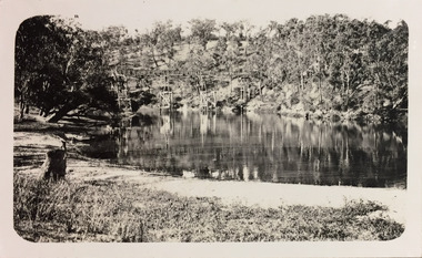
Henry Beater Christian (1886-1962) , was a descendant of one of the earliest settler families in Kew. Employed at the Kew Asylum as a 'public servant', he was a skilled amateur photographer, photographing numerous scenes in Kew and on his travels around Victoria. The majority of his photographs date from 1916 to 1929. His finest photographs are housed in two photograph albums. Digital copy of a photograph from page 8 of the 47-page photograph album containing 261 gelatinous silver images, loaned by Diane Washfold with permission given to digitise and hold a copy in our collection. The Zig-Zag Bridge linked the grounds of the Yarra Bend and Kew Asylums. The wooden bridge was constructed in the 1870s and lasted through numerous floods until its destruction in 1929. A horizontal structure, the walkway was reached via a wooden staircase. The steps were requires due to the different levels of the banks on this stretch of the river. The photo is taken from the Kew side of the river. "Zig-Zag Bridge"henry beater christian (1886-1962), landscape photography, kew (vic.) — yarra river, christian-washfold collection, photograph albums, zig-zag bridge -
 Kew Historical Society Inc
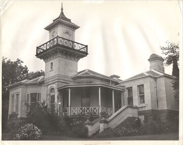
Photograph, J E & B L Rogers, 'Swinton', Swinton Avenue, c.1960
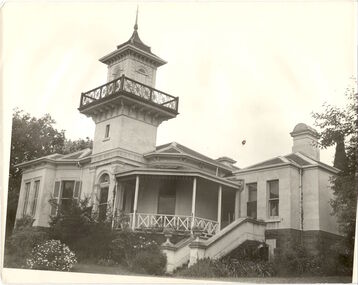
'The land on which 'Swinton'was later built was first purchased by John Bakewell in 1851 and later sold to Edmund Laskey Splatt in 1858. Splatt was a member of the first provisional committee of the National Bank of Australia in Melbourne and built the first house on the land naming it 'Laskey Villa'. By 1863 the house was occupied by Herbert Henty. The Johnson family connection with the property began with the marriage in 1858 of Annabella Johnson to David Syme, owner of the Áge' newspaper and owner of the adjacent property 'Blytheswood'. Annabella's brother, Francis Johnson, bought the villa in 1876 and renamed it 'Swinton' after his birthplace in Yorkshire. The property was later owned by the artistic Colquhoun family. The house is one of the earliest examples of the Italianate style in Victoria - the outstanding element being the tower with its cantilevered walkway and heavily bracketed pryamidal tower.' Source: Victorian Heritage RegisterThis work forms part of the collection assembled by the historian Dorothy Rogers, that was donated to the Kew Historical Society by her son John Rogers in 2015. The manuscripts, photographs, maps, and documents were sourced by her from both family and local collections or produced as references for her print publications. Many were directly used by Rogers in writing ‘Lovely Old Homes of Kew’ (1961) and 'A History of Kew' (1973), or the numerous articles on local history that she produced for suburban newspapers. Most of the photographs in the collection include detailed annotations in her hand. The Rogers Collection provides a comprehensive insight into the working habits of a historian in the 1960s and 1970s. Together it forms the largest privately-donated collection within the archives of the Kew Historical SocietySwinton in Kew and its tower. This side of the house faces the Yarra River.swinton, laskey villa, swinton avenue, kew, dorothy rogers -
 Kew Historical Society Inc
Photograph - Demolishing the Zig-Zag Bridge, 1929
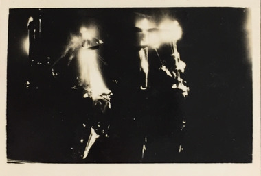
Henry Beater Christian (1886-1962) , was a descendant of one of the earliest settler families in Kew. Employed at the Kew Asylum as a 'public servant', he was a skilled amateur photographer, photographing numerous scenes in Kew and on his travels around Victoria. The majority of his photographs date from 1916 to 1929. His finest photographs are housed in two photograph albums. Rare photograph of the demolition of the Zig-Zag Bridge linking the two asylums on either side of the Yarra River.Digital copy of a photograph from page 16 of the 47-page photograph album containing 261 gelatinous silver images, loaned by Diane Washfold with permission given to digitise and hold a copy in our collection. The Zig-Zag Bridge linked the grounds of the Yarra Bend and Kew Asylums. The wooden bridge was constructed in the 1870s and lasted through numerous floods until its destruction in 1929. A horizontal structure, the walkway was reached via a wooden staircase on the Kew bank of the river. The steps were required due to the different levels of the banks on this stretch of the river. This night-time photograph shows the remaining parts of the bridge being destroyed by fire."Demolishing Zig-Zag / 6. 1929"henry beater christian (1886-1962), landscape photography, kew (vic.) — yarra river, christian-washfold collection, photograph albums, zig-zag bridge -
 Kew Historical Society Inc
Photograph - Demolishing the Zig-Zag Bridge, 1929
Henry Beater Christian (1886-1962) , was a descendant of one of the earliest settler families in Kew. Employed at the Kew Asylum as a 'public servant', he was a skilled amateur photographer, photographing numerous scenes in Kew and on his travels around Victoria. The majority of his photographs date from 1916 to 1929. His finest photographs are housed in two photograph albums. Rare photograph of the demolition of the Zig-Zag Bridge linking the two asylums on either side of the Yarra River.Digital copy of a photograph from page 16 of the 47-page photograph album containing 261 gelatinous silver images, loaned by Diane Washfold with permission given to digitise and hold a copy in our collection. The Zig-Zag Bridge linked the grounds of the Yarra Bend and Kew Asylums. The wooden bridge was constructed in the 1870s and lasted through numerous floods until its destruction in 1929. A horizontal structure, the walkway was reached via a wooden staircase on the Kew bank of the river. The steps were required due to the different levels of the banks on this stretch of the river. This is a photo of the bridge before part of it was destroyed in a flood in 1929. A man, perhaps Henry Christian, stands at the right of the foreground."Demolishing Zig-Zag / 6. 1929"henry beater christian (1886-1962), landscape photography, kew (vic.) — yarra river, christian-washfold collection, photograph albums, zig-zag bridge -
 Glenelg Shire Council Cultural Collection
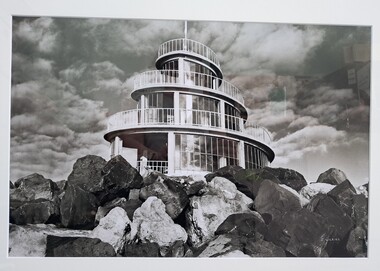
Photograph, John Wilkins, Photographer, Corkscrew, n.d
From the Port of Portland website: The original corkscrew was built as a gift to the Portland Harbour Trust by the contractors who constructed the port. It was designed in 1960 and fabricated shortly after the completion of the Main Breakwater. The corkscrew was built as an observatory, with the observation deck approximately 13 metres above sea level. Its original design life was less than 25 years. The original structure was dilapidated, extremely unsafe and in danger of collapse. Understanding the historical and community importance of the original structure, in 2016 Port of Portland began the process of designing and building a replacement. The new corkscrew is a similar size and has been based on the same spiral shape of the original structure. The corkscrew has been constructed using mild steel, heavily coated in marine grade paint (similar to what is used on ships). Heavy duty plastic has been used for the walkway section which will withstand the harsh elements of the marine environment.Photograph of the Portland Corkscrew in the 1980s. Image is in black and white. The corkscrew is in front of a sky which is dotted with fluffy clouds. To the front of the Corkscrew are large rocks. The building is a spiral with glass windows. There is a white metal fence around it and a white pole at the top which reaches to the top of the image.Bottom right: J WILKINSportland, seafront, maritime, portland landmark, corkscrew, port of portland, portland photography, photography -
 Stawell Historical Society Inc
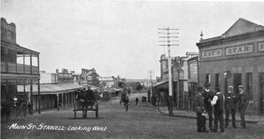
Photograph, Main Street Stawell looking West c1907. Kay's Star Hotel on Right
Main Street Looking West. Kays Star Hotel c1907 The Star Hotel had a chequered life. Like a number of other hotels it started life on Commercial Street Pleasant Creek, the first License being held by Mr. William Francis in 1858. It was shifted to Main Street Quartz Reefs in 1860 and had many tenants over a long period. For many years it stood in the centre of the roadway in Main Street and had to be moved to give more room for traffic. It is one of the reasons we have a bend in the Main Street. As a Hotel it had 54 years without a conviction against it. Although it had many licensees it was owned by one family for the last 27 years of its life as a Hotel. It was delicensed in 1916 because it was too close to the Albion which was a better building. Currently (2025) occupied by the Stawell Club and is licensed. The walkway beside it to the carpark is names Star Lane.Main Street Stawell looking West c1907. Bull & Mouth Hotel with verandahs on Left, Kay's Star Hotel on Right. Group of men talking in roadway at right. Telegraph pole prominent near centre of photo.Main St. Stawell Looking West.stawell, hotel -
 Bendigo Historical Society Inc.
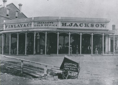
Photograph - HENRY JACKSON, GOLD BUYER OF VIEW POINT, CHARING CROSS, 1861
Black and white photograph. Single storey building with verandah. Two storey brick building at L. At least 12 adult males standing under verandah. L foreground wooden bridge / walkway. Photographer's car CF. In image on building 'Finlay & Co/Jackson's Gold Office, H Jackson'. On cart in image 'Photographer, Pall Mall'. Inclusion in envelope - typewritten is 'Henry Jackson, gold buyer of View Point, Charing Cross where Aussie Disposals are now operating. On the right is the first building of the Bank of New South Wales. The railing marked where the creek then meandered. Photograph by Batchelder, taken in 1861. (Bendigo Historical Society Inc.) History of object James Lerk 28.2.2000 Batchelder photo (copy) 1861, View Point. See Mosaic 1228 for further information.buildings, commercial, henry jackson, gold buyer -
 Kew Historical Society Inc
Photograph - Demolishing the Zig-Zag Bridge, 1929
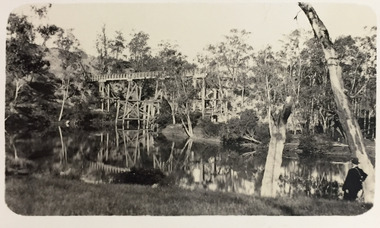
Henry Beater Christian (1886-1962) , was a descendant of one of the earliest settler families in Kew. Employed at the Kew Asylum as a 'public servant', he was a skilled amateur photographer, photographing numerous scenes in Kew and on his travels around Victoria. The majority of his photographs date from 1916 to 1929. His finest photographs are housed in two photograph albums. Rare photograph of the demolition of the Zig-Zag Bridge linking the two asylums on either side of the Yarra River.Digital copy of a photograph from page 16 of the 47-page photograph album containing 261 gelatinous silver images, loaned by Diane Washfold with permission given to digitise and hold a copy in our collection. The Zig-Zag Bridge linked the grounds of the Yarra Bend and Kew Asylums. The wooden bridge was constructed in the 1870s and lasted through numerous floods until its destruction in 1929. A horizontal structure, the walkway was reached via a wooden staircase on the Kew bank of the river. The steps were required due to the different levels of the banks on this stretch of the river. The photo is of the bridge after its partial destruction in a flood. An empty boat floats on the river. There is a car on the far bank and a man sits on one of the cross supports preparing to set the structure alight."Demolishing Zig-Zag / 6. 1929"henry beater christian (1886-1962), landscape photography, kew (vic.) — yarra river, christian-washfold collection, photograph albums, zig-zag bridge -
 Lakes Entrance Historical Society
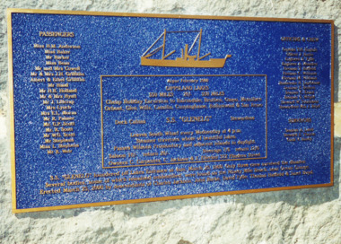
Photograph - The "Glenelg" Lakes Entrance, 25/3/2000
The "Glenelg" sank off the coast of 90 mile beach after leaving Lakes Entrance with the loss of 37 lives, only three survived. The passengers had embarked on a cruise to the lakes. It was announced on the Evening News when the wreck of the Glenelg was found 100 years later. LERHS has reference material on the inquest collected and donated by Ian Boyd whose grandmother was Stewardess aboard the GlenelgHistoricalColour photograph of memorial plaque on bluestone plinth on walkway beside Cunninghame Arm in memory of the lives lost on the wreck of the SS Glenelg Lakes Entrance Victoria. Also colour photographs taken at the unveiling of the memorial plaque by descendants of those lost on the "Glenelg" which sank on 25th March 1900. Named: Phyllis and Ian Boyd; Jeanne Davidson great granddaughter of Hilda Anderson; Aileen Knox, Ian Boyd, Elinor Boyd, Janet Gilbert, great grandchildren of Janet Boyd (Stewardess )who was lost on the Glenelg. Also two colour photographs taken when the Glenelg wreck was discovered off 90 mile beach 100 years after it was lost, showing divers who found the wreck, and announcer from TV News making the announcement. township, waterfront, shipwrecks, memorials -
 Eltham District Historical Society Inc
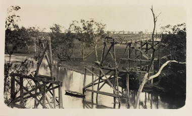
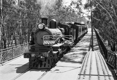
Photograph, VR Commissioner's Special train, steam locomotive D3-639 crossing the Echuca-Moama Road Rail Bridge over the Murray River from Moama, NSW to Echuca, Victoria, 1962
VR Commissioner's Special train, steam locomotive D3-639 crossing the Echuca-Moama Road Rail Bridge over the Murray River from Moama, NSW to Echuca, Victoria. Commissioner Edgar Henry Brownbill on footplate, 1962. Commissioner Edgar Henry Brownbill was in office 1957 to 1967. George Coop advises - "The train on the Eltham/Moama bridge is actually the Commissioner’s Special on one of its inspection tours of the VR rail system. This was a very grand special train with accommodation for the Commissioner and staff in carriages also used once for the Royal Train and other State purposes. You can just see the Commissioner of the day, dressed in his suit and wearing engine drivers gloves, standing in the loco cab doorway. A good ‘hands on’ impression is created amongst local staff if can be seen that the boss is no ‘desk jockjey’. The observation car on the back was originally made for the ’Spirit of Progress’. I climbed up onto the bridge iron plate work to get this view. It was safe enough as the cantilevered pedestrian walkway was still on the east side at the time." "I was resident in Echuca from Jan. ’59 to approx. May ’64. At that time the single Echuca/Moama bridge was a combined road/rail bridge. The rail gauge was 5’3” and still is, I believe, on the new bridge that sits just upstream of the old one. This rail line into NSW has always been 5’3" gauge because it has no connection with any NSW tracks. The old Echuca/Moama bridge, locally called the ‘Iron Bridge’ has, over years, undergone some structural changes. The two lattice iron hoops arcing over the roadway have been raised and lowered and changed design. Presently a pedestrian walkway is cantilevered off the west (or downstream) side of the bridge. It used to be on the eastern side. Guess changes went in when new rail bridge only was built on the eastern side as well." Image dated as c.1963 based on same image in Port of Echuca collection (possibly frame 32 of film) (print 19.5 x 24.5cm) On reverse in pencil: "Brown card" in black pen: "Commissioners special. F. Brown on Footplate. George C.L. Coop c1963". https://victoriancollections.net.au/items/59d575b921ea6e1278d78042 However based on frame no. 10, date set as 1962Digital TIFF file Scan of 35mm Ilford FP3 black and white negative transparencyd3-639, d3-class steam locomotive, echuca-moama road rail bridge, edgar henry brownbill, george coop collection, murray river, vr commissioner's special train -
 Kew Historical Society Inc
Photograph - Zig-Zag Bridge, 1924
Henry Beater Christian (1886-1962) , was a descendant of one of the earliest settler families in Kew. Employed at the Kew Asylum as a 'public servant', he was a skilled amateur photographer, photographing numerous scenes in Kew and on his travels around Victoria. The majority of his photographs date from 1916 to 1929. His finest photographs are housed in two photograph albums. Digital copy of a photograph from page 8 of the 47-page photograph album containing 261 gelatinous silver images, loaned by Diane Washfold with permission given to digitise and hold a copy in our collection. This photograph reveals how the photographer, Henry Christian, positioned himself to take the photograph from the angle in which he was interested. A skilled canoeist, an empty canoe is on the left bank that he apparently he used to access his vantage point. His subject, the Zig-Zag Bridge linked the grounds of the Yarra Bend and Kew Asylums. The wooden bridge was constructed in the 1870s and lasted through numerous floods until its destruction in 1929. A horizontal structure, the walkway was reached via a wooden staircase on the Studley Park end. The steps were requires due to the different levels of the banks on this stretch of the river. "Zig-Zag Bridge"henry beater christian (1886-1962), landscape photography, kew (vic.) — yarra river, christian-washfold collection, photograph albums, zig-zag bridge -
 Kew Historical Society Inc
Photograph - Zig-Zag Bridge, 1924
Henry Beater Christian (1886-1962) , was a descendant of one of the earliest settler families in Kew. Employed at the Kew Asylum as a 'public servant', he was a skilled amateur photographer, photographing numerous scenes in Kew and on his travels around Victoria. The majority of his photographs date from 1916 to 1929. His finest photographs are housed in two photograph albums. Digital copy of a photograph from page 8 of the 47-page photograph album containing 261 gelatinous silver images, loaned by Diane Washfold with permission given to digitise and hold a copy in our collection. This photograph reveals how the photographer, Henry Christian, positioned himself to take the photograph from the angle in which he was interested. A skilled canoeist, an empty canoe is on the left bank that he apparently he used to access his vantage point. His subject, the Zig-Zag Bridge linked the grounds of the Yarra Bend and Kew Asylums. The wooden bridge was constructed in the 1870s and lasted through numerous floods until its destruction in 1929. A horizontal structure, the walkway was reached via a wooden staircase on the Studley Park side. The steps were requires due to the different levels of the banks on this stretch of the river. "Zig-Zag Bridge"henry beater christian (1886-1962), landscape photography, kew (vic.) — yarra river, christian-washfold collection, photograph albums, zig-zag bridge -
 Kew Historical Society Inc
Photograph, J E & B L Rogers, 'Swinton', Swinton Avenue, c.1960
This work forms part of the collection assembled by the historian Dorothy Rogers, that was donated to the Kew Historical Society by her son John Rogers in 2015. The manuscripts, photographs, maps, and documents were sourced by her from both family and local collections or produced as references for her print publications. Many were directly used by Rogers in writing ‘Lovely Old Homes of Kew’ (1961) and 'A History of Kew' (1973), or the numerous articles on local history that she produced for suburban newspapers. Most of the photographs in the collection include detailed annotations in her hand. The Rogers Collection provides a comprehensive insight into the working habits of a historian in the 1960s and 1970s. Together it forms the largest privately-donated collection within the archives of the Kew Historical Society."The land on which Swinton was later built was first purchased by John Bakewell in 1851 and later sold to Edmund Laskey Splatt in 1858. Splatt was a member of the first provisional committee of the National Bank of Australia in Melbourne and built the first house on the land naming it Laskey Villa. By 1863 the house was occupied by Herbert Henty. The Johnson family connection with the property began with the marriage in 1858 of Annabella Johnson to David Sym - owner of The Age newspaper and owner of the adjacent property Blytheswood. Annabella's brother, Francis Johnson, bought the villa in 1876 and renamed it Swinton after his birthplace in Yorkshire. The property was later owned by the artistic Colquhoun family. The house is one of the earliest examples of the Italianate style in Victoria - the outstanding element being the tower with its cantilevered walkway and heavily bracketed pyramidal tower. (Source: Victorian Heritage Database)"Swinton. Built about 1959-60. Chap.20 Swinton. Johnson - Col"swinton, swinton avenue (kew)