Showing 947 items
matching annotations
-
 Bendigo Military Museum
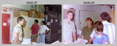
Photograph - Army Survey Regiment Open Day – Lithographic Squadron, Fortuna, Bendigo, 1990
These 18 photographs were taken at an Army Survey Regiment Open Day at Fortuna Villa, Bendigo on the 24th of February 1990. This occasion was one of several events held to commemorate the 75th anniversary of the formation of the Royal Australian Survey Corps. Although historical tours of Fortuna occurred on a regular basis, this was the first technical open day since 1972. The Royal Australian Survey Corps recognised that an Open Day was the best way for the local community in Bendigo to gain an insight into the unit’s important role as Defence’s map production agency, its technical equipment, and its economic importance to Bendigo. It also gave them an opportunity to tour through historic Fortuna Villa. This occasion is covered in more detail in page 143 of Valerie Lovejoy’s book 'Mapmakers of Fortuna – A history of the Army Survey Regiment’ ISBN: 0-646-42120-4. Refer to items 6434.27P and 6435.35P for more photos of the Open Day taken inside Fortuna, the garden areas and Map Production areas of Air Survey and Cartographic Squadron. Photo prints of some of these photos were scanned and catalogued in items 6247.30P and 6291.6P.These 18 photographs were taken at an Army Survey Regiment Open Day held at Fortuna, Bendigo on the 24th of February 1990. The 35mm colour and black & white negatives photographs were scanned at 96 dpi and are part of the Army Survey Regiment’s Collection. .1) - Photo, colour, 1990. Print Troop – WO2 Rob Bogumil with visitors. .2) - Photo, colour, 1990. Print Troop – L to R: SPR Ross Anza, LCPL Janet Murray with visitors. .3) - Photo, black & white, 1990. Print Troop – L to R: LCPL Janet Murray, MAJ Bob Coote, SPR Gary Lord with visitors. .4) - Photo, black & white, 1990. Photo Troop – L to R: WO2 Keith Fenton RE UK Exchange, SGT Steve Burke with visitors. .5) - Photo, colour, 1990. Photo Troop – SGT Steve Burke with visitors. .6) - Photo, colour, 1990. Photo Troop – L to R: unidentified, SGT Steve Burke with visitors. .7) - Photo, colour, 1990. Print Troop – L to R: CPL Peter Breukel, WO2 Keith Fenton RE. UK Exchange with visitors. .8) - Photo, black & white, 1990. Photo Troop - WO2 Keith Fenton RE. UK Exchange. .9) - Photo, black & white, 1990. Print Troop - civilian visitors. .10) - black & white, Print Troop, 1990. - L to R: civilian visitors, SSGT Ian Nichols, CPL John ‘Flash’ Anderson. .11) - Photo, black & white, 1990. Print Troop - L to R: SSGT Ian Nichols, CPL Dale Hudson, Planeta printing press, with civilian visitors. .12) - Photo, colour, 1990. Print Troop - L to R: SSGT Ian Nichols, CAPT Roger Hancock with civilian visitors. .13) - Photo, colour, 1990. Print Troop - LT Marty Lyons with civilian visitors. .14) - Photo, black & white, 1990. Print Troop - L to R: LT Marty Lyons, unidentified with civilian visitors. .15) - Photo, black & white, 1990. Orthophoto Mapping Section - L to R: SSGT Peter Imeson, SGT Bob Garritty with civilian visitors. .16) - Photo, colour, 1990. Optronics raster scanner - WO2 Adrian ‘Charlie’ Creedy with civilian visitors. .17) - Photo, colour 1990. Outside Photo Troop office - L to R: SSGT Rhys De Laine, WO2 Rob Bogumil. .18) - Photo, black & white, 1990. Photo Troop - civilian visitors..1P to .18P – no annotationsroyal australian survey corps, rasvy, army survey regiment, army svy regt, fortuna, asr, litho sqn -
 Bendigo Military Museum
Photograph - RSM-Army Visit – Technical Tour, Army Survey Regiment Fortuna, Bendigo, 1989
This is a set of 16 photographs of a visit to the Army Survey Regiment, by the Regimental Sergeant-Major of the Australian Army (RSM-A) WO1 Kevin (Lofty) Wendt OAM, BEM on the 10th of August 1989. He was taken on a tour through the production areas and messes. RSM-A WO1 Kevin (Lofty) Wendt OAM, BEM was the 2nd RSM to be appointed to the position of RSM-A, the most senior Warrant Officer position in the Australian Army. His appointment was from 1987 to 1990. On this occasion he was escorted by WO1 Neville Stone, who was the RSM of the Army Survey Regiment from 1988 to 1990. Refer to item 6438.15P for photos of the SGT’s Mess function.This is a set of 16 photographs of a visit to the Army Survey Regiment, Fortuna, Bendigo by the Regimental Sergeant-Major of the Australian Army (RSM-A) WO1 Kevin (Lofty) Wendt OAM, BEM on the 10th of August 1989. The photographs are on 35mm negative film and were scanned at 96 dpi. They are part of the Army Survey Regiment’s Collection. .1) to .2) - Photo, black & white, 1989. Wild B8 plotting on the AUTOMAP 2 system, L to R: WO1 Russell ‘Rusty’ Williams, RSM-A WO1 Kevin (Lofty) Wendt OAM, BEM, SPR Stuart Bowd. .3) to .5) - Photo, black & white, 1989. RAAF Charting, L to R: SSGT Dennis Learmonth, RSM-A WO1 Kevin (Lofty) Wendt OAM, BEM. .6) - Photo, black & white, 1989. RAAF Charting, L to R: SSGT Dennis Learmonth, RSM-A WO1 Kevin (Lofty) Wendt OAM, BEM, unidentified visiting RSM, WO1 Stevo Hinic. .7) to .8) - Photo, black & white, 1989. Map data editing on AUTOMAP 2 system, L to R: SPR Charmian McKean, RSM-A WO1 Kevin (Lofty) Wendt OAM, BEM, WO1 Stevo Hinic. .9) - Photo, black & white, 1989. Map data editing on AUTOMAP 2 system, L to R: SGT Paul ‘Hutch’ Hunter, RSM-A WO1 Kevin (Lofty) Wendt OAM, BEM. .10) - Photo, black & white, 1989. Photo Troop L to R: RSM-A WO1 Kevin (Lofty) Wendt OAM, BEM, WO2 Rob Bogumil. .11) - Photo, black & white, 1989. Print Troop L to R: CPL Peter Swandale, RSM-A WO1 Kevin (Lofty) Wendt OAM, BEM. .12) - Photo, black & white, 1989. Print Troop L to R: RSM-A WO1 Kevin (Lofty) Wendt OAM, BEM, unidentified visiting RSM, CPL Peter Swandale. .13) - Photo, black & white, 1989. OR’s Mess Committee, Tavern L to R: RSM-A WO1 Kevin (Lofty) Wendt OAM, BEM, PMC CPL Brendon McKinless. .14) - Photo, black & white, 1989. OR’s Mess Committee, Tavern L to R: CPL Noel Brinsmead, CPL John Gilbert. .15) - Photo, black & white, 1989. OR’s Mess Committee, Tavern L to R: PMC CPL Brendon McKinless, RSM-A WO1 Kevin (Lofty) Wendt OAM, BEM, CPL Noel Brinsmead, CPL John Gilbert, CPL AM Verley. .16) - Photo, black & white, 1989. OR’s Mess Committee, Tavern L to R: RSM WO1 Neville Stone, PMC CPL Brendon McKinless, RSM-A WO1 Kevin (Lofty) Wendt OAM, BEM, CPL Noel Brinsmead, CPL John Gilbert, CPL AM Verley, CPL Dave Cook..1P to .16P – no annotationsroyal australian survey corps, rasvy, army survey regiment, army svy regt, fortuna, asr -
 Bendigo Military Museum
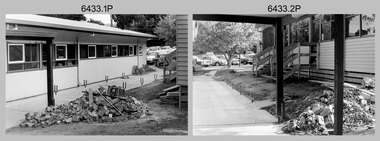
Photograph - Air Survey Squadron building refurbishment - Army Survey Regiment Fortuna, Bendigo, c1982
This set of 20 black & white photographs of the refurbishment of Air Survey Squadron’s production areas, was taken in circa 1982. These refurbishments were most likely in preparation of the AUTOMAP 2 production system and to accommodate the expansion of the Army Survey Regiment’s work force. This photo set also includes the exterior and interior of a new building - 16A, a modular building of several sections transported in and joined together as part of the expansion. Another modular building - 16B was added later in the 1980s to accommodate Technical Services. The two buildings eventually were removed after Fortuna was sold by Defence in 2008.This set of 20 black & white photographs of the refurbishment of Air Survey Squadron’s production areas, was taken in circa 1982. The photographs are on 35mm negative film. They are part of the Army Survey Regiment’s Collection. The photographic negatives were scanned at 96 dpi. .1) to .2) - Photo, black & white, c1982. Air Survey Squadron building refurbishment. Pathway between Building 16 and Building 16A. .3) to .4) - Photo, black & white, c1982. Air Survey Squadron Building 16 refurbishment. .5) - Photo, black & white, c1982. Air Survey Squadron’s CAPT Chris ‘Monty’ Gehrmann. .6) - Photo, black & white, c1982. AUTOMAP 1 system, L to R: SGT Jim Gill, unidentified. .7) - Photo, black & white, c1982. AUTOMAP 1 system, SGT Bruce Bowers. .8) - Photo, black & white, c1982. AUTOMAP 1 system, unidentified staff. .9) - Photo, black & white, c1982. Technical Services - L to R: Tony Spurling, Joe Farrrington. .10) - Photo, black & white, c1982. Technical Services - Tony Spurling. .11) to .12) - Photo, black & white, c1982. Technical Services, unidentified staff. .13) - Photo, black & white, c1982. Air Survey Squadron, L to R: SPR Nick Van Dalen, SSGT Les Dixon, unidentified. .14) - Photo, black & white, c1982. Air Survey Squadron, L to R: SGT Greg Byers, WO1 Graeme Birrell. .15) - Photo, black & white, c1982. Air Survey Squadron, L to R: SSGT Bruce Gordon, CPL Dave Irving, SGT Phil Meagher, SSGT Brett ‘Dutchy’ Van Leeuwin. .16) - Photo, black & white, c1982. Air Survey Squadron, L to R: SGT Mick Hogan, CPL John Gilbert, SPR Lorraine (Daly) Talbot-Smith, SPR Santina (Argetto) Straube. .17) - Photo, black & white, c1982. Air Survey Squadron, L to R: CPL Dave Irving, SSGT Bruce Gordon, SGT Phil Meagher, SSGT Brett ‘Dutchy’ Van Leeuwin. .18) - Photo, black & white, c1982. Air Survey Squadron, L to R: CPL Dave Irving, SGT Phil Meagher. .19) - Photo, black & white, c1982. Air Survey Squadron, L to R: SPR Lorraine (Daly) Talbot-Smith, SGT Mick Hogan, CPL Dave Irving. .20) - Photo, black & white, c1982. Air Survey Squadron, L to R: SGT Phil Meagher, CPL Dave Irving, SSGT Brett ‘Dutchy’ Van Leeuwin, SSGT Bruce Gordon,.1P to .20P – no annotationsroyal australian survey corps, rasvy, army survey regiment, army svy regt, fortuna, asr, photogrammetry, automap 1 -
 Bendigo Military Museum
Photograph - RSM-Army Visit – SGT’s Mess Function, Army Survey Regiment Fortuna, Bendigo, 1989
This is a set of 15 photographs of a visit to the Army Survey Regiment, by the Regimental Sergeant-Major of the Australian Army (RSM-A) WO1 Kevin (Lofty) Wendt OAM, BEM on the 10th of August 1989. He was taken on a tour through the production facilities and messes. RSM-A WO1 Kevin (Lofty) Wendt OAM, BEM was the 2nd RSM to be appointed to the position of RSM-A, the most senior Warrant Officer position in the Australian Army. His appointment was from 1987 to 1990. On this occasion he was escorted by WO1 Neville Stone, who was the RSM of the Army Survey Regiment from 1988 to 1990. Refer to item 6437.16P for photos of the production facilities tour.This is a set of 15 photographs of a visit to the Army Survey Regiment (ASR) , Fortuna, Bendigo by the Regimental Sergeant-Major of the Australian Army (RSM-A) WO1 Kevin (Lofty) Wendt OAM, BEM on the 10th of August 1989. The photographs are on 35mm negative film and were scanned at 96 dpi. They are part of the Army Survey Regiment’s Collection. .1) - Photo, black & white, 1989. L to R: ASR RSM WO1 Neville Stone, RSM-A WO1 Kevin (Lofty) Wendt OAM, BEM. .2) - Photo, black & white, 1989. L to R: WO2 Rowan Gillies, SGT Noel McNamara, SGT Bruce Hammond, SGT Roger Rees, WO2 George Graham. .3) - Photo, black & white, 1989. L to R: unidentified, WO2 Steve Egan. WO1 Trevor Osborne, RSM-A WO1 Kevin (Lofty) Wendt OAM, BEM, unidentified, SGT Frank Lenane. .4) - Photo, black & white, 1989. L to R: ASR RSM WO1 Neville Stone, John ‘Stormy’ Tempest, SSGT Brad Peppler. .5) - Photo, black & white, 1989. L to R: RSM-A WO1 Kevin (Lofty) Wendt OAM, BEM, WO2 Barry Lutwyche OAM, SGT Steve Burke, SGT Frank Lenane, SGT Peter Imeson. .6) to .9) - Photo, black & white, 1989. Dinner is served - unidentified Catering Corps staff. .10) - Photo, black & white, 1989. Dinner is served - L to R: RSM-A WO1 Kevin (Lofty) Wendt OAM, BEM, ASR RSM WO1 Neville Stone. .11) - Photo, black & white, 1989. Dinner is served - L to R: ASR RSM WO1 Neville Stone, RSM-A WO1 Kevin (Lofty) Wendt OAM, BEM, WO1 Stevo Hinic, WO2 George Graham, unidentified, SSGT Brad Peppler, SGT Bob Garritty, SGT Paul Hopes. .12) - Photo, black & white, 1989. Dinner is served - unidentified Catering Corps staff. .13) - Photo, black & white, 1989. L to R: SGT Greg Anderson, RSM-A WO1 Kevin (Lofty) Wendt OAM, BEM. .14) - Photo, black & white, 1989. L to R: unidentified, SSGT Rick van der Bom. .15) - Photo, black & white, 1989. L to R: SGT Greg Anderson, unidentified, back of RSM-A WO1 Kevin (Lofty) Wendt OAM, BEM, unidentified..1P to .15P – no annotationsroyal australian survey corps, rasvy, army survey regiment, army svy regt, fortuna, asr -
 Bendigo Military Museum
Photograph - Lithographic Squadron Group Photos, Army Survey Regiment, Fortuna Villa, Bendigo, 1990
This is a set of 15 photographs of personnel posted to Lithographic Squadron at the Army Survey Regiment, Fortuna Villa, Bendigo Victoria, on the 1st of October 1990. These informal and formal group photos were taken on the day of a CO’s Parade. It is not known why sunglasses were worn at the Squadron parade outside the Litho huts. Photos of the other three Squadrons, the Officers, and Warrant Officers/Sergeants from this set of negatives are catalogued in item 6440.11P. This is a set of 15 photographs of personnel posted to Lithographic Squadron at the Army Survey Regiment, Fortuna Villa, Bendigo Victoria, on the 1st of October 1990. The photographs are on 35mm negative film and were scanned at 96 dpi. They are part of the Army Survey Regiment’s Collection. .1) &.2) - Photo, black & white, 1990. OC MAJ Bob Coote. .3) - Photo, black & white, 1990. Front rank L to R: SPR Ken Labouchardiere, SPR Doug Whiteside, SPR Mark McCullogh. Centre rank L to R: SPR Andrew Woodman. Rear rank L to R: CPL Geoff Webb, CPL Daryl South. .4) - Photo, black & white, 1990. Front rank L to R: SSGT Russ Mollenhauer, SGT Kim Reynolds, SGT Brian Paul, unidentified, SPR Ken Labouchardiere, SPR Doug Whiteside, Centre rank L to R: SPR Graeme Spong, SPR Andrew Woodman. Rear rank L to R: SGT Steve Burke, CPL Geoff Webb. .5) - Photo, black & white, 1990. WO1 Trevor Osborne. .6) - Photo, black & white, 1990. LCPL Damien Cole. .7) - Photo, black & white, 1990. L to R: WO2 Rhys De Laine, WO2 Steve Egan, WO2 Keith Fenton RE UK Exchange, WO2 Rob Bogumil, WO1 Bill Jones. .8) - Photo, black & white, 1990. L to R: SPR Shane ‘Smily’ Campbell, SPR Andrew Woodman, CPL Daryl South. .9) - Photo, black & white, 1990. LT Greg Tolcher. .10) - Photo, black & white, 1990. SGT Steve Burke. .11) - Photo, black & white, 1990. Lithographic Squadron: Back row L to R: SPR Ross Anza, SGT Brian Fauth, unidentified, SPR Andrew Arman, SGT Gary Kerr, SPR Doug Whiteside, SSGT Russ Mollenhauer, CPL Peter Swandale, CPL Roy Hicks, SPR Shane ‘Smily’ Campbell, SPR Graeme Spong. Jones. 3rd row L to R: SSGT Garry Drummond, SGT Kim Reynolds, unidentified, SGT Brian Paul, CPL Gavin Mclean, SPR Mark McCullogh, CPL Le-Anne (Smallshaw) Shirley, CPL Geoff Webb, SPR Gary Lord, SSGT Di Chalmers, CPL Peter Dillon, LCPL Damien Cole, SGT Steve Burke. 2nd row L to R: SSGT Peter Imeson, SPR Gary Sievers, unidentified, CPL Daryl South, SPR Greg Howell, SPR Janet Murray, SPR Michelle Withers, SPR Ken Labouchardiere, SPR John Bragg, SPR Andrew Morrison-Evans, CPL John ‘Flash’ Anderson, CPL Trevor King. Front row L to R: WO2 Steve Egan, WO1 Trevor Osborne, LT Greg Tolcher, WO2 Rob Bogumil (standing), OC MAJ Bob Coote, LT Marty Lyons, WO2 Rhys De Laine, WO2 Keith Fenton RE UK Exchange, WO2 Jeff Willey. .12) & .13) - Photo, black & white, 1990. Lithographic Squadron: Back row L to R: SPR Ross Anza, SGT Brian Fauth, unidentified, SPR Andrew Arman, SGT Gary Kerr, SPR Doug Whiteside, SSGT Russ Mollenhauer, CPL Peter Swandale, CPL Roy Hicks, SPR Shane ‘Smily’ Campbell, SPR Graeme Spong. Jones. 3rd row L to R: SSGT Garry Drummond, SGT Kim Reynolds, unidentified, SGT Brian Paul, CPL Gavin Mclean, SPR Mark McCullogh, CPL Le-Anne (Smallshaw) Shirley, CPL Geoff Webb, SPR Gary Lord, SSGT Di Chalmers, CPL Peter Dillon, LCPL Damien Cole, SGT Steve Burke. 2nd row L to R: SSGT Peter Imeson, SPR Gary Sievers, unidentified, CPL Daryl South, SPR Greg Howell, SPR Janet Murray, SPR Michelle Withers, SPR Ken Labouchardiere, SPR John Bragg, SPR Andrew Morrison-Evans, CPL John ‘Flash’ Anderson, CPL Trevor King. Front row L to R: WO2 Steve Egan, WO1 Trevor Osborne, LT Greg Tolcher, WO2 Rob Bogumil, OC MAJ Bob Coote, LT Marty Lyons, WO1 Bill Jones, WO2 Rhys De Laine, WO2 Keith Fenton RE UK Exchange, WO2 Jeff Willey. .14) - Photo, black & white, 1990. L to R: WO2 Rob Bogumil, unidentified, OC MAJ Bob Coote, CPL Daryl South, unidentified (x3), CPL Roy Hicks, SSGT Di Chalmers, WO2 Jeff Willey, WO2 Keith Fenton RE UK Exchange, SPR Ken Labouchardiere, WO2 Rhys De Laine. .15) - Photo, black & white, 1990. L to R: SPR Greg Howell, SPR Gary Sievers, unidentified, SPR Ross Anza, unidentified (x4), SSGT Russ Mollenhauer, SPR Doug Whiteside, SGT Brian Paul, unidentified (x7), WO2 Jeff Willey, unidentified, WO2 Keith Fenton RE UK Exchange, WO2 Rhys De Laine, SPR Shane ‘Smily’ Campbell..1P to .15P – no annotationsroyal australian survey corps, rasvy, army survey regiment, army svy regt, fortuna, asr, litho sqn -
 Bendigo Military Museum
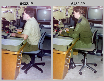
Photograph - Capturing Topographic Features with a Wild B8, AUTOMAP 2 Systems Operations – Army Survey Regiment, Fortuna, Bendigo, 1990
This is a set of two photographs of Air Survey Squadron technicians - LCPL Peter Murphy and SPR Rachel (Stanford) Scott capturing topographic features with a Wild B8 stereo plotter with AUTOMAP 2 equipment at the Army Survey Regiment, Fortuna, Bendigo, c1990. Refer to item 6185.4P and 6204.8P for detailed information and additional photographs of the Wild B8 stereo plotter. The history of the AUTOMAP 2 system is covered in more detail with additional historic photographs in pages 119, 137-142 and 180 of Valerie Lovejoy’s book 'Mapmakers of Fortuna – A history of the Army Survey Regiment’ ISBN 0-646-4: 2120-4. See items 6087.10P and 6223.23P for additional photographs of the AUTOMAP 2 system.This is a set of two photographs of Air Survey Squadron technicians capturing topographic features with a Wild B8 stereo plotter with AUTOMAP 2 equipment at the Army Survey Regiment at Fortuna, Bendigo, c1990. The photographs are on 35mm negative film. They are part of the Army Survey Regiment’s Collection. The photographic negatives were scanned at 96 dpi. .1) - Photo, colour, 1990. LCPL Peter Murphy operating a Wild B8 stereo plotter. .2) - Photo, colour, 1990. SPR Rachel (Stanford) Scott operating a Wild B8 stereo plotter..1P to .2P – no annotationsroyal australian survey corps, rasvy, army survey regiment, army svy regt, fortuna, asr, photogrammetry -
 Bendigo Military Museum
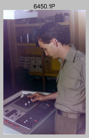
Photograph - KLIMSCH Large Format Camera and Wild OR1 Orthorectification Equipment - Army Survey Regiment, Fortuna, Bendigo, c1986
The main tasks undertaken by technicians operating the KLIMSCH Commodore large format camera were enlargements and reductions of map reproduction material. seen in photo .1P is at the operating console. See item 6189.4P for more information and photos of CPL Whaling operating the KLIMSCH camera. Orthophoto mapping provided the Survey Corps with the capability to produce map products quickly in the event of a crisis. These are four photographs of equipment used by the Army Survey Regiment to produce orthophotomaps. The WILD OR1 orthophoto projector and workstation shown in photos .3P and .4P was introduced in the mid-1980s. It was the second-generation equipment used to orthorectify colour and monochrome film aerial photography, replacing the system introduced in 1973. See items 6124.5P and 6133.4P for more photographs of orthorectification equipment.These four photographs of KLIMSCH large format camera and Wild OR1 orthorectification equipment was taken at the Army Survey Regiment at Fortuna, Bendigo, c1986. The colour photographs are on 35mm negative film and scanned at 96 dpi. They are part of the Army Survey Regiment’s Collection. .1) - Photo, colour, c1986, CPL John Whaling operating the KLIMSCH Camera. .2) - Photo, colour, c1986, large format film developer. .3) - Photo, colour, c1986, WILD OR-1 Orthorectification Workstation operated by CPL Dave Jobe. .4) - Photo, colour, c1986, WILD OR-1 Orthorectification Workstation..1P to .4P – There are no annotations.royal australian survey corps, rasvy, army survey regiment, army svy regt, fortuna, asr -
 Bendigo Military Museum
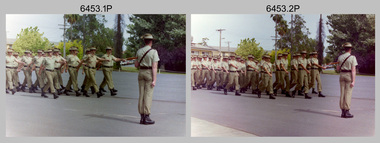
Photograph - Officer Commissioning and CO’s Handover Parade, Army Survey Regiment, Fortuna Villa, Bendigo, 1992
This is a set of 28 photographs taken at a CO’s Parade at the Army Survey Regiment, Fortuna, Bendigo in 1992. On this parade WO1 Bill Jones received his commission and by promotion to Captain from CO LTCOL Rene van den Tol. Command of the unit was handed over to LTCOL Rob McHenry. It is probable the commissioning and handover ceremonies occurred on the CO’s Parade. LTCOL Rene van den Tol was CO from 1989 to 1992 and LTCOL Rob McHenry was CO from 1992 to 1993.This is a set of 28 photographs taken at a CO’s Parade at the Army Survey Regiment, Fortuna, Bendigo in 1992. The colour photographs are on 35mm negative film and scanned at 96 dpi. They are part of the Army Survey Regiment’s Collection. .1) - Photo, colour, 1992. Headquarters Squadron marches past RSM WO1 Graham Ragless. .2) - Photo, colour, 1992. Cartographic Squadron marches past RSM WO1 Graham Ragless. L to R: unidentified personnel, WO2 Steve Hansen, CPL Roger Pearson, WO1 Gary Warnest, SSGT Dennis Learmonth, SSGT Greg Else, CPL Ian Bowes, SGT Stuart Symonds. .3) - Photo, colour, 1992. Lithographic Squadron marches past RSM WO1 Graham Ragless. L to R: unidentified personnel, WO1 Steve Egan, LCPL John Bragg, unidentified personnel, WO2 Rob Bogumil, unidentified personnel, SPR Corey Hill. .4) - Photo, colour, 1992. Air Survey Squadron marches past RSM WO1 Graham Ragless. L to R: unidentified personnel, WO1 Allan Hancox, SSGT Wolfgang Thun, unidentified personnel, WO2 Neil ‘Ned’ Kelly, unidentified personnel, SGT Dave Longbottom, SGT Brian Johnson. .5) - Photo, colour, 1992. Cartographic Squadron. L to R: unidentified personnel, SGT Stuart Symonds, CPL Col McInnes, CAPT Mary Anne Martinek in foreground, SPR Jodi Seith, unidentified personnel, SPR Avril (Bray) Lloyd. .6) - Photo, colour, 1992. Air Survey Squadron. L to R: unidentified officer, SSGT Bruce Hammond, SPR Tracy Tillman, SPR Rachel (Stanford) Scott, SPR Paula (Golding) Brinsmead, SGT Graeme Reany, unidentified officer in foreground, unidentified personnel, CPL Steve Coulson. .7) - Photo, colour, 1992. Cartographic Squadron inspection. L to R: RSM WO1 Graham Ragless, unidentified, OC MAJ Graeme Wastell, CO LTCOL Rene van den Tol, unidentified personnel, CPL Col McInnes, SPR Jodi Seith, SPR Avril (Bray) Lloyd. CPL Steve Ellis, SPR Ian Brown, SPR Andrew Lazdovskis. .8) - Photo, colour, 1992. Cartographic Squadron inspection. L to R: OC MAJ Graeme Wastell, CO LTCOL Rene van den Tol, SPR Avril (Bray) Lloyd, CPL Steve Ellis, SPR Ian Brown, SPR Andrew Lazdovskis, SPR Adrian Taylor, unidentified, SPR Mick Knight, SPR Dawn Hoadley, CPL Craig Kellet. .8) to .12) - Photo, colour, 1992. Officer Commissioning Ceremony. L to R: CO LTCOL Rene van den Tol, WO1 Bill Jones promoted to Captain. .13) - Photo, colour, 1992. Officer Commissioning Ceremony. L to R: ADJT CAPT Geoff Ford, RSM WO1 Graham Ragless, CO LTCOL Rene van den Tol, WO1 Bill Jones promoted to Captain. .14) - Photo, colour, 1992. Officer Commissioning Ceremony. WO1 Bill Jones promoted to Captain. .15) - Photo, colour, 1992. Commanding Officer Handover. CO LTCOL Rene van den Tol delivers speech. .16) to .17) - Photo, colour, 1992. Commanding Officer Handover. R to L: CO LTCOL Rene van den Tol hands over to incoming CO LTCOL Rob McHenry. .18) - Photo, colour, 1992. Commanding Officer Handover. L to R: RSM WO1 Graham Ragless, ADJT CAPT Geoff Ford, CO LTCOL Rob McHenry. .19) - Photo, colour, 1992. Commanding Officer Handover. L to R: ADJT CAPT Geoff Ford, RSM WO1 Graham Ragless, CO LTCOL Rob McHenry. .20) - Photo, colour, 1992. Cartographic Squadron marches off parade ground. L to R: OC MAJ Graeme Wastell, unidentified officer, CAPT Greg Oaten, LT Matt Jackson, CAPT Mary Anne Martinek, SPR Mick Knight. .21) & .22) - Photo, colour, 1992. Cartographic Squadron marches off parade ground. .23) - Photo, colour, 1992. Lithographic Squadron marches off parade ground. L to R: OC Bob Coote, unidentified officer, SPR Scott Cameron, unidentified officer, SSGT Russ Mollenhauer, SGT Brian Fauth. .24) - Photo, colour, 1992. Lithographic Squadron marches off parade ground. L to R: LCPL Janet Murray, unidentified, SPR Mick Muzeen, Allison (Ottaway) Wooldrage, SGT Keith Quinton, SGT Frank Lenane, SGT Laurie Justin, SGT Dale Hudson, LCPL John Bragg, unidentified, SGT Kim Reynolds, SPR Corey Hill, SPR Andrew Arman, SPR Ross Anza, WO1 Peter Coombes. .25) - Photo, colour, 1992. Parade guests. L to R: unidentified guests, MAJ Peter Jensen. .26) - Photo, colour, 1992. Parade guests. L to R: unidentified guests, CAPT Doug Arman, unidentified guests. .27) - Photo, colour, 1992. Parade personnel march off. L to R: unidentified, WO2 Ted Burgess, WO1 Ken Slater. .28) - Photo, colour, 1992. Parade personnel. L to R: unidentified, SPR Allan Blake..1P to .28P – There are no annotations.royal australian survey corps, rasvy, army survey regiment, army svy regt, fortuna, asr -
 Bendigo Military Museum
Photograph - Lithographic Squadron Personnel and Equipment, Army Survey Regiment, Fortuna, Bendigo, c1990
These 28 photographs of Lithographic Squadron personnel and equipment was taken at Fortuna, Bendigo circa 1990. The photos were taken on the east side of Fortuna Villa, the Print Room’s map trimming and dispatch work area and the inside and outside Air Survey Support Section (BARCRO).These 28 photographs of Lithographic Squadron Personnel and Equipment was taken at Fortuna, Bendigo circa 1990. The 35mm colour photograph negatives were scanned at 96 dpi and are part of the Army Survey Regiment’s Collection. .1) - Photo, colour, c1990. RAEME and maintenance support, unidentified civilian. .2) - Photo, colour, c1990. Eastern side of Fortuna Villa, unidentified, CPL Le-Anne (Smallshaw) Shirley. .3) - Photo, colour, c1990. Eastern side of Fortuna Villa, SGT Gary Kerr. .4) - Photo, colour, c1990. Eastern side of Fortuna Villa, CPL Roy Hicks. .5) - Photo, colour, c1990. Eastern side of Fortuna Villa, unidentified. .6) - Photo, colour, c1990. Unidentified passing Q-Store & Transport Compound. .7) - Photo, colour, c1990. Data Management & Map Library. .8) - Photo, colour, c1990. Unidentified officer passing Q-Store heading up to Map Library. .9) - Photo, colour, c1990. Eastern side of Fortuna Villa, SPR Michelle Withers. .10) - Photo, colour, c1990. Unidentified RAEME soldier passing Q-Store heading up to Map Library. .11) & .12) - Photo, colour, c1990. Delivery of bulk map printing paper. WO2 Jeff Willey on forklift, unidentified. .13) & .14) - Photo, colour, c1990. Print Room, Wohlenberg MCS-2 guillotine. .15) to .18) - Photo, colour, c1990. Air Survey Support Section (BARCRO), Carl Zeiss Rectifying Enlarger. .19) - Photo, colour, c1990. Air Survey Support Section (BARCRO), film contact frame. .20) - Photo, colour, c1990. Air Survey Support Section (BARCRO), Pakotone film development processors. .21) & .22) - Photo, colour, c1990. Air Survey Support Section (BARCRO) entry/exit. .23) & .24) - Photo, colour, c1990. Air Survey Support Section (BARCRO) miscellaneous equipment. .25) & .26) - Photo, colour, c1990. Air Survey Support Section (BARCRO), CPL Warren ‘Waldo’ Shirley. .27) & .28) - Photo, colour, c1990. Outside Air Survey Support Section (BARCRO), L to R: WO1 Peter Coombes, CPL Warren ‘Waldo’ Shirley..1P to .28P – There are no annotations.royal australian survey corps, rasvy, army survey regiment, army svy regt, fortuna, asr, litho sqn -
 Bendigo Military Museum
Photograph - Army Survey Regiment SGT’s Mess Summer Ball – Dinner, c1990
This is a set of 14 photographs taken at the Warrant Officer and Sergeant’s Mess Summer Ball held at the Army Survey Regiment (ASR), Fortuna Villa circa 1990. Photos of personnel and their guests was taken during the dinner and social mingling outside the SGT’s Mess. The Ball and Dinner was held in the gardens of Fortuna Villa and in temporary 20’ x 30’ Army tents set up on the roadway in front of the transport compound. Australian Army Catering Corps staff provided the catering. Refer to item 6454.24P for additional photographs taken at the Summer Ball. An additional 21 photos of less historical value have been scanned but not published.This is a set of 14 photographs taken at the Warrant Officer and Sergeant’s Summer Ball held at the Army Survey Regiment, Fortuna Villa circa 1990. The colour photographs are on 35mm negative film and are part of the Army Survey Regiment’s Collection. The photographs were scanned at 96 dpi. .1) - Photo, colour, c1990. Dinner preparation in SGT’s Mess kitchen. .2) - Photo, colour, c1990. Dinner buffet presentation inside 20’ x 30’ Army tent. .3) - Photo, colour, c1990. Dinner buffet. L to R: June Danger, WO1 Gary Warnest, Terry Danger, Judy Warnest, RSM WO1 Graham Ragless, unidentified guest. .4) - Photo, colour, c1990. Dinner buffet. Unidentified guests and Australian Army Catering Corps staff. .5) - Photo, colour, c1990. Dinner. Unidentified members and guests. .6) - Photo, colour, c1990. Dinner. L to R: members and guests (x3), SSGT Doug Carswell, unidentified guests (x4). .7) - Photo, colour, c1990. Dinner. SSGT Paul Davis and his partner Julie. Unidentified guests in background. .8) - Photo, colour, c1990. Dinner. L to R: SSGT Dennis Learmonth, unidentified guests (x3), MAJ Ray Redman, unidentified guests (x9). .9) - Photo, colour, c1990. Dinner. SGT Trevor Clark with his partner. .10) - Photo, colour, c1990. Dinner. L to R: unidentified guests (x3), WO1 Allan Virtue with his partner, unidentified guests (x6). .11) - Photo, colour, c1990. Dinner. L to R: unidentified members and guests (x4), SSGT Steve Hill CSM, unidentified guest. .12) - Photo, colour, c1990. Unidentified steward serves drinks at SGT’s Mess bar. .13) - Photo, colour, c1990. L to R: SSGT Noel McNamara, SGT Peter Peterson unidentified guests (x2) at OR’s Mess bar. .14) - Photo, colour, c1990. L to R: unidentified guest, WO1 Barry Lutwyche OAM, SSGT Noel McNamara, unidentified members and guests (x3), SGT Peter Peterson, unidentified guests (x2) outside SGT’s Mess..1P to .14P – There are no annotations.royal australian survey corps, rasvy, army survey regiment, army svy regt, fortuna, asr -
 Bendigo Military Museum
Photograph - Army Survey Regiment SGT’s Mess Summer Ball - Warrant Officers, Sergeants and Guests Arrival, c1990
This is a set of 24 photographs taken at the Warrant Officer and Sergeant’s Mess Summer Ball held at the Army Survey Regiment (ASR), Fortuna Villa circa 1990. Photos of personnel and their guests was taken on their arrival in locations inside Fortuna Villa and its surrounding gardens. The Ball and Dinner was held in the gardens of Fortuna Villa and in temporary 20’ x 30’ Army tents set up on the roadway in front of the transport compound. Australian Army Catering Corps staff provided the catering. Refer to item 6455.14P for additional photographs taken at the Summer Ball. An additional 21 photos of less historical value have been scanned but not published.This is a set of 24 photographs taken at the Warrant Officer and Sergeant’s Summer Ball held at the Army Survey Regiment, Fortuna Villa circa 1990. The colour photographs are on 35mm negative film and are part of the Army Survey Regiment’s Collection. The photographs were scanned at 96 dpi. .1) - Photo, colour, c1990. WO2 Tom Pattison with his partner. .2) - Photo, colour, c1990. WO2 Tom Pattison (at rear) with his partner and guests. .3) - Photo, colour, c1990. Terry Danger with his partner June. .4) - Photo, colour, c1990. L to R: unidentified guests (x2), Terry Danger and his partner June. .5) - Photo, colour, c1990. WO1 Brett Van Leeuwen with his partner Juana. .6) - Photo, colour, c1990. SGT Graham Hales with his partner April. .7) - Photo, colour, c1990. SGT Graham Hales with his partner April. .8) - Photo, colour, c1990. WO2 Phil Smalley with his partner Donna. .9) - Photo, colour, c1990. SSGT Peter Imeson with his partner. .10) - Photo, colour, c1990. Unidentified SGT with his partner. .11) - Photo, colour, c1990. SGT Steve Drummond with his partner Helen. .12) - Photo, colour, c1990. RSM WO1 Graham Ragless with his partner. .13) - Photo, colour, c1990. WO2 Mick Flynn with his partner Carol. .14) - Photo, colour, c1990. WO1 Steve Hansen with his partner. .15) - Photo, colour, c1990. WO1 Wayne Rothwell with his partner Karen. .16) - Photo, colour, c1990. SSGT Steve Hill CSM with his partner. .17) & .18) - Photo, colour, c1990. SSGT Noel McNamara with his partner. .19) & .20) - Photo, colour, c1990. SGT Gary Kerr with his partner. .21) - Photo, colour, c1990. WO1 Allan Virtue with his partner. .22) - Photo, colour, c1990. SGT Brian Paul with his partner. .23) & .24) - Photo, colour, c1990. Unidentified SSGT with his partner..1P to .24P – There are no annotations.royal australian survey corps, rasvy, army survey regiment, army svy regt, fortuna, asr -
 Bendigo Military Museum
Photograph - Army Survey Regiment – Defence Force Service Medal Presentations, c1967, c1976-1980
This is a set of nine photographs of medal presentations at the Army Survey Regiment, Fortuna, Bendigo. In photos .1P to .8P, the Defence Force Service Medal was presented to personnel in recognition of 15 years of efficient remunerated service, or the Clasp for each further 5-year period of service. The photos were taken on four separate occasions. Photos .1P to .3P were taken on the parade ground. LTCOL John Nolan was the CO of the Army Headquarters Survey Regiment from 1965 to 1969. He was subsequently promoted to COL and was the Director of Military Survey from 1972 to 1975. MAJ Lionel ‘Bill’ Sprenger MBE, MID was subsequently promoted to LTCOL and was the CO of the unit from 1969 to 1970. Photos .4P to .7P were taken in circa mid-1970s and Photo .8P was taken on Friday 21 October 1976. Photos .4P to .8P were taken next to the flagpole in Fortuna Villa’s front garden. This is a set of nine photographs of medal presentations at the Army Survey Regiment, Bendigo circa 1960s-1970s. The photographs were printed on photographic paper and are part of the Army Survey Regiment’s Collection. The photographs were scanned at 300 dpi. .1) - Photo, black & white, c1967. L to R: MAJ Lionel ‘Bill’ Sprenger MBE, MID; unidentified visiting General, CO LTCOL John Nolan, LT Jack McNeale. .2) - Photo, black & white, c1967. L to R: MAJ Lionel ‘Bill’ Sprenger MBE, MID; unidentified visiting General, CO LTCOL John Nolan, WO1 Jack Gore. .3) - Photo, black & white, c1967. L to R: MAJ Lionel ‘Bill’ Sprenger MBE, MID; unidentified visiting General, CO LTCOL John Nolan, WO2 Bob McGaritty. .4) & .5) - Photo, black & white, c1976. L to R: WO1 Don Taylor, BRIG Jim SHELTON DSO, MC, MID. .6) & .7) - Photo, black & white, c1976. L to R: SGT Syd Davis, Brigadier Jim SHELTON DSO, MC, MID. .8) - Photo, black & white, 1976. L to R: SSGT Gordon Haswell, WO1 Marj Knight, MAJGEN John Williamson AO, OBE GOC FF COMD. .9) - Photo, black & white, c1976-1980. L to R: unidentified (x2), WO2 John McCulloch, unidentified, WO1 Darby Munro, CO LTCOL Bob Skitch, unidentified visiting General..1P to .9P – no annotationsroyal australian survey corps, rasvy, army survey regiment, army svy regt, fortuna, asr -
 Bendigo Military Museum
Photograph - Visit by MAJ GEN Taylor to the Army Headquarters Survey Regiment, Fortuna, Bendigo, 1966
This is a set of two photographs of a visit to the Army Headquarters Survey Regiment, Fortuna. Bendigo in 1966, by MAJ GEN Taylor, GOC Southern Command. He was escorted by the CO - LTCOL Frank Buckland OBE, MID. LTCOL Frank Buckland OBE, MID was the CO of the Army Headquarters Survey Regiment from 1962 to 1965. After promotion to Colonel, he was appointed as Director of the Royal Australian Survey Corps from March 1967 to August 1972. COL Buckland OBE, MID was promoted to Brigadier (retired) to the honorary position as Colonel Commandant from January 1973 to January 1976. He served in the Australian Army from 01 June 1938 to 31 October 1972.This is a set of two photographs of MAJ GEN Taylor’s visit to the Army Headquarters Survey Regiment, Fortuna, Bendigo in 1966. The photographs were printed on photographic paper and are part of the Army Survey Regiment’s Collection. They were scanned at 300 dpi. .1) - Photo, black and white, 1966. L to R: MAJ GEN Taylor, CO LTCOL Frank Buckland OBE. .2) - Photo, black and white, 1966. L to R: MAJ Eddy Anderson MBE, MAJ GEN Taylor, CO LTCOL Frank Buckland OBE, unidentified (x2). .1P to .2P – no annotationsroyal australian survey corps, rasvy, army survey regiment, army svy regt, fortuna, asr -
 Bendigo Military Museum
Photograph - Royal Australian Survey Corps Personnel – School of Military Survey, Bonegilla and Army Survey Regiment, Bendigo, 1977 to 1989
This is a collection of 19 photographs of Royal Australian Survey Corps personnel taken at the School of Military Survey (SMS), Bonegilla and the Army Survey Regiment (ASR), Bendigo from 1977 to 1989. Personnel identified in photographs .1P to .6P were attending their initial employment training at the SMS. Personnel identified in the remaining photographs were posted to the ASR in the 1980s.This is a collection of 19 photographs of Royal Australian Survey Corps personnel probably taken at the School of Military Survey, Bonegilla and the Army Survey Regiment, Bendigo from 1977 to 1989. The black and white and colour photographs are printed on photographic paper and scanned at 300 dpi. They are part of the Army Survey Regiment Collection. .1) - Photo, black & white, c1977 Wolfgang Thun. .2) - Photo, black & white, c1977, Alan Wilkins. .3) - Photo, black & white, c1977, Scott Hatten. .4) - Photo, black & white, c1977, Mark Casey. .5) - Photo, black & white, c1977, Marty George. .6) - Photo, black & white, c1977, Mark Lander. .7) - Photo, black & white, c1980s, L to R: Chris ‘Charlie’ Brown, Jamie ‘Fish’ McRae. .8) - Photo, black & white, c1980s, L to R: Scott Payne, Steve Drummond. .9) - Photo, black & white, c1980s, David Murphy. .10) - Photo, black & white, c1980s, Bob Sheppard. .11) - Photo, black & white, c1980s, Lyall Camp. .12) - Photo, black & white, c1980s, Peter ‘Spoon’ Lefel. .13) - Photo, black & white, c1980s, L to R: Greg Honan, Jann (Caithness) Lambton-Young. .14) - Photo, black & white, c1980s, L to R: Brian Fauth – partially obscured, Mick Gillham, Sherri (Dally) Burke, Gordon Lowery. .15) - Photo, black & white, c1980s, Lorraine (Daly) Talbot-Smith. .16) - Photo, black & white, c1980s, Lance Strudwick. .17) - Photo, black & white, c1980s, L to R: Geunther Ebenwaldner – partially obscured, Roy Hicks. .18) - Photo, black & white, c1980s, L to R: Paul Hopes, Steve Drummond, Rob Straube. .19) - Photo, black & white, c1980s, L to R: Geunther Ebenwaldner – facing away, unidentified, Bob Thrower. .1P to .19P The are no annotations.royal australian survey corps, rasvy, army survey regiment, army svy regt, fortuna -
 Federation University Historical Collection
Letter, Letter from Young Anglican Fellowship - Ballarat Zone Council to Ballarat School of Mines, 02/04/1958
The Ballarat School of Mines was created in 1870, and developed to become the educational facility it is today. Richard W. Richards was Principal of the school in 1958. This letter is from the Young Anglican Fellowship, Ballarat Zone Council's secretary Ian Thompson, thanking Principal of the School of Mines, for the loan of a work-bench to create a Begonia Festival float. The Begonia Festival is an annual Ballarat Festival, that began in 1953 to celebrate the eponymous flower. Letter from Young Anglican Fellowship - Ballarat Zone Council to Ballarat School of Mines, with pen annotations and signatures. ballarat begonia festival, school of mines, young anglican fellowship, ballarat zone council, ian thompson, work-bench, letter, principal, thanks, 1958, sebastopol, richard w richards, dick richards, r w richards -
 Bendigo Historical Society Inc.
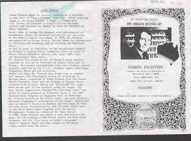
Document - MERLE HALL COLLECTION: BENDIGO PERFORMANCE OF SIMON PRESTON (ORGAN RECITAL)
Bendigo Performance of Simon Preston (organ recital) April 10th - with pencilled annotation of ''? 86''. Programme (2 copies). -
Kew Historical Society Inc
Flyer - 60 Pakington Street, Kew
Subdivision plans and real estate flyers/brochures reveal a number of aspects of urban development and history. The Kew Historical Society's collection of these plans, as well as advertisements extracted from magazines, cover key aspects of community development and architectural history of Kew and Kew Eat as well as surrounding suburbs. While most of the plans in the collection were gifted to the Society by the former City of Kew, a number of other plans and advertisements have been donated by individuals, of which this is an example. Single page illustrated flyer, advertising 60 Pakington Street, Kew for sale. Annotation in pen and ink at right.neville collection, 60 pakington street -- kew (vic.), real estate advertisements -- kew (vic.) -
 Returned Nurses RSL Sub-branch
Document - Photocopy of a typed and hand-written document, Charles E Stuart, A. I. F. - 1939 - 1945, unknown
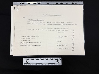
'List of Nursing Staff - 8th Division, evacuated from Singapore on steamship "Vyner Brooke" on 12th February 1942, and subsequent fates.' Table list column headings: Surnames; Initials (etc); Unit; Enlisted; Fate. Also provides other recommended sources with some statistics on the final page.A4 photocopy of a typed and hand-written document with hand-written annotations. Document is a list table in five columns.'Mr & MRS Jim ROGERS' [blue ink in the top right hand corner of the first page] '(NOW MRS FRANK STATHAM [WAS]) [blue ink on the lower right hand side of the first page]vyner brooke, ss vyner brooke, singapore, wwii, ww2, world war 2 -
 Bendigo Military Museum
Photograph - George Mann Printing Presses operating at the Army Survey Regiment, c1960s
These five photographs of the George Mann printing presses were probably taken circa 1960s in Lithographic Squadron at the Army Survey Regiment, Fortuna, Bendigo. The photos are not annotated except for .4P. The George Mann Fast Five Printing Press was a two-colour demy quad offset press. It was a robust and well-made lithographic printing machine built by the George Mann company in Leeds, UK. The two presses were in service at the Army Svy Regt in the 1960s and 1970s and replaced with the Komori and Planeta offset printing presses in 1975 and 1976 respectively.This is a set of photographs of the George Mann Printing Presses operational at the Army Survey Regiment, Bendigo from c1960s to 1970s. The photographs were printed on photographic paper and are part of the Army Survey Regiment’s Collection. The photographs were scanned at 300 dpi. .1) - Photo, black & white, c1960s, printing press, Lithographic Squadron .2) - Photo, black & white, c1960s, unidentified, printing press, Lithographic Squadron .3) - Photo, black & white, c1960s, printing press, Lithographic Squadron .4) - Photo, black & white, c1960s, SPR Howard Dingle, Lithographic Squadron .5) - Photo, black & white, c1960s, printing presses, Lithographic Squadron.1 to .3 – no annotation .4 - personnel names (with rank) annotated on back. .5 – no annotation royal australian survey corps, rasvy, army survey regiment, army svy regt, fortuna, asr, printing, litho -
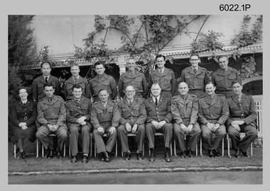 Bendigo Military Museum
Photograph - Commissioned Officers of the Army Survey Regiment, c1962-1965, 1972, c1973-1974
These photographs of Royal Australian Survey Corps commissioned officers was taken at the Army Survey Regiment circa 1962-1965, 1972 and circa 1973-1974. Officer appointments to the Army Svy Regt were typically the CO, 2IC, Adjutant; and an OC, 2IC and Troop Officers assigned to the Headquarters, Topographic/Air Survey, Cartographic and Lithographic Squadrons. RAN and RAAF liaison officers were usually appointed to the Regiment; and occasionally exchange officers from other Corps, the USA or UK.This is a set of photographs of RASvy Officers at the Army Survey Regiment, Bendigo. The photographs were printed on photographic paper and are part of the Army Survey Regiment’s Collection. The photographs were scanned at 300 dpi. .1) - Back row – L to R: Unknown Philippines officer, LT Merv Marks, LT Jorge Gruszka, LT Bill Greer, CAPT Peter Constantine, LT Freddy High, MAJ Brian Dalton.Front row – L to R: CAPT Carol Castor, MAJ NRJ Hillier, MAJ Bill Howarth, CO LTCOL Frank Buckland, DSVY-A COL Don Macdonald, GEN Miller – US Director Mapping, MAJ John Nolan, MAJ Eddy Anderson MBE, unknown UK Exchange Officer. .2) - Photo, black & white, c1972. Back row – L to R: CAPT Jack Gore, LT Royal, FLT Sinclair, LT Fred Brown, LT John Winzar, LT Gary Kenney, LT Reg Smith, 2LT Terry Edwards, LT Bob Roche. Front row – L to R: CAPT McNeale, 2LT William, MAJ Keith Todd, MAJ Don Ridge, LTCOL Bill Howarth, MAJ Brian Dalton, MAJ John Bullen, LT C. Chittleborough, LT Bailey .3) - Photo, black & white c1972. Back row – L to R: 1st 2LT Terry Edwards, 7th LT Gary Kenney, 9th LT Bob Roche. Front row – L to R: 1st CAPT Jack Gore, 3rd LT Bailey, 4th MAJ Keith Todd, 5th MAJ Don Ridge, 6th LTCOL Bill Howarth, 7th MAJ Brian Dalton, 8th MAJ John Bullen, 9th FLT Sinclair, 10th CAPT McNeale. .4) - Photo, black & white, c1972. Personnel named as per .3) .5) - Photo, black & white, c1973-1974. Back row – L to R: 1st LT Graham Baker, 4th MAJ John Sinclair , 7th CAPT Reg Smith, 8th LT Terry Edwards. Front row – L to R: 3rd MAJ Peter Constantine, 4th LTCOL Don Ridge 5th MAJ John Cattell. .6) - Photo, colour print of .5), c1973-1974 Personnel named as per .5).1 no annotation, .2 Personnel (surnames, no rank) annotated on back, .3 to .6 no annotationroyal australian survey corps, rasvy, army survey regiment, army svy regt, fortuna, asr -
 Kew Historical Society Inc
Document - Manuscript, Dorothy Rogers, Register of Inscriptions, Boroondara General Cemetery / by Dorothy Rogers, 1965-70
This work forms part of the collection assembled by the historian Dorothy Rogers, that was donated to the Kew Historical Society by her son John Rogers in 2015. The manuscripts, photographs, maps, and documents were sourced by her from both family and local collections or produced as references for her print publications. Many were directly used by Rogers in writing ‘Lovely Old Homes of Kew’ (1961) and 'A History of Kew' (1973), or the numerous articles on local history that she produced for suburban newspapers. Most of the photographs in the collection include detailed annotations in her hand. The Rogers Collection provides a comprehensive insight into the working habits of a historian in the 1960s and 1970s. Together it forms the largest privately-donated collection within the archives of the Kew Historical Society.Typed manuscript with additional hand written annotations compiled by the historian Dorothy Rogers of inscriptions on headstones at Kew Cemetery. It includes in alphabetical order the names of the deceased and the inscription on the headstone. In cases where the headstone no longer exists Rogers has listed details from the Cemetery's files. The manuscript also includes some inscriptions from churches. Importantly the manuscript includes inscriptions on tablets in the now demolished Congregational Church in Walpole Street. boroondara general cemetery, dorothy rogers -
 Greensborough Historical Society
Document - Certificate of Title, Alison land, 1840o
Land originally granted to John Alison 09/09/1840. Shows chain of ownership from Alison to Lecky, Mayger (Magyar) and Blay; Lecky to Charles Buck; Mayger to Whatmough.Shows part of the chain of ownership of this parcel of land in Greensborough.4 pages. Copies of land titles and associated documentsSome annotations by Noel Withersland titles - greensborough, mayger family, whatmough family -
 Greensborough Historical Society
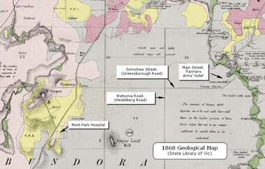
Map - Geological Map, 1868 Geological map of Greensborough (annotated), 1868_
This geological map from the State Library of Victoria collection has been annotated by GHS member Ian Bryant to show some local landmarksDigital copy of colour map.Annotations on map show locations.greensborough - maps, 1860s melbourne, suburbs, geography, roads -
 National Wool Museum
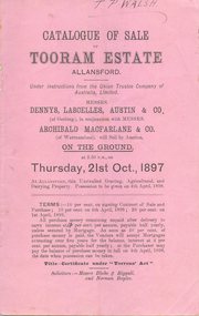
Catalogue, Catalogue of Sale of "Tooram" Estate, Allansford, 21st Oct, 1897
Catalogue of Sale of "Tooram" Estate, Allansford, 21st Oct, 1897, by Dennys Lascelles, Austin & Co and Archibald Macfarlane & CoT P WALSH annotationspastoral industry - history land enclosure, dennys, lascelles, austin & co archibald macfarlane & co, tooram, allansford, pastoral industry - history, land enclosure -
 Kew Historical Society Inc
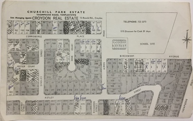
Plan - Subdivision Plan, Churchill Park Estate, Templestowe
Historic subdivision plan of the Churchill Park Estate in Templestowe.Undated subdivision plan advertising the Churchill Park Estate inTemplestowe. Streets identified in the plan include: Corroboree Place, Astley Street, Jeffrey Street, Airds Road, Dove Court, Potter Court, Thompsons Road, Richards Street, and Birchwood Avenue.Annotations in ink on the plan by agentsubdivision plans - templestowe (vic), churchill park estate - templestowe (vic) -
 Kew Historical Society Inc
Plan - Subdivision Plan, Churchill Park Estate, Templestowe
Historic subdivision plan of the Churchill Park Estate in Templestowe.Undated subdivision plan advertising the Churchill Park Estate inTemplestowe. Streets identified in the plan include: Corroboree Place, Astley Street, Jeffrey Street, Airds Road, Dove Court, Potter Court, Thompsons Road, Richards Street, and Birchwood Avenue. This record includes a copy of the price list.Annotations in ink on the plan by agentsubdivision plans - templestowe (vic), churchill park estate - templestowe (vic) -
!['Ellesmere', Princess Street [Kew]](/media/collectors/550653872162f11fb04854aa/items/658f623d101c4283c6ae94cb/item-media/658f6272101c4283c6ae9580/item-fit-380x285.jpg) Kew Historical Society Inc
Kew Historical Society IncPhotograph - 'Ellesmere', Princess Street [Kew], c.1950
A National Trust (Vic) citation records that Ellesmore [sic] was: 'A late Victorian Villa in the grand manner but completed to a meaner standard in the Edwardian Period. Notable for the mannerist porticos surmounted by a sepulchre motif: the central vestibule at the intersection of the two major axes, with lantern lighting from above: and the art nouveau woodwork of the drawing room'.This work forms part of the collection assembled by the historian Dorothy Rogers (1905-1973), donated to the Kew Historical Society by her son in 2015. The manuscripts, photographs, maps, and documents were sourced by her from both family and local collections or produced as references for her print publications. Many were directly used by Rogers in writing ‘Lovely Old Homes of Kew’ (1961) and 'A History of Kew' (1973), or the numerous articles on local history that she produced for suburban newspapers. Most of the photographs in the collection include detailed annotations in her hand. The Rogers Collection provides a comprehensive insight into the working habits of a historian from the 1960s to the 1970s. Faded monochrome snapshot of 'Ellesmere'Annotation verso: "Porch of Ellesmere"dorothy rogers, ellesmere -- princess street -- kew (vic), houses -- princess street (kew) -
 Kew Historical Society Inc
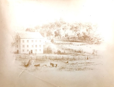
Print, Sands & Kenny, Dights Mill, 1856
"In 1839 John Dight purchased Melbourne block 88, which included 26 acres of land along the Yarra River for £481 at the Port Phillip land sales held in Sydney. Dight was already in the business of flour milling and had a mill near Campbell Town in New South Wales called ‘Ceres’. In April 1840, he notified his customers through The Sydney Herald that he was leaving to go to Port Phillip. The first steam powered flour mill was constructed in Melbourne in 1841. Dight built his water powered mill, soon after, from bricks bought over from Tasmania. Dight used the river to power his mill: Water flowed along an inlet channel to turn an undershot water wheel. In order to regulate flow or to ensure flow for times when river levels were low, Dight constructed a rough stone weir." (Melbourne Water)Dights Mill. Reproduction of a book plate from an original wood engraving, showing Dights Mill and Falls on the River Yarra. The image was originally published in Sands & Kenny, Melbourne & Sydney.Annotation on reverse: "Dights Flour".dights mill, yarra river -
University of Melbourne, Burnley Campus Archives
Booklet (item) - Prospectus, Diploma Course in Horticulture
Some annotations by T.H. Kneen?burnley college of horticulture, victoria department of agriculture, prospectus, diploma course in horticulture -
Kew Historical Society Inc
Flyer - 45 Pakington Street, Kew
Subdivision plans and real estate flyers/brochures reveal a number of aspects of urban development and history. The Kew Historical Society's collection of these plans, as well as advertisements extracted from magazines, cover key aspects of community development and architectural history of Kew and Kew Eat as well as surrounding suburbs. While most of the plans in the collection were gifted to the Society by the former City of Kew, a number of other plans and advertisements have been donated by individuals, of which this is an example.Single page illustrated real estate flyer advertising 45 Pakington Street, Kew for sale by auction. Annotation in pen and ink at rightpeter neville, real estate advertisements -- kew (vic.), 45 pakington street -- kew (vic.)