Showing 157 items
matching australian geography
-
 Victorian Aboriginal Corporation for Languages
Book, John Henderson, Language in native title, 2002
Introduction /? John Henderson and David Nash Language and native title /? John Henderson Linguistic evidence and native title cases in Australia /? Peter Sutton Linguistic continuity in colonised country /? Jeanie Bell Country and the word: linguistic evidence in the Croker Sea claim /? Nicholas Evans Linguistics and the Yorta Yorta native title claim /? Heather Bowe The language of the Peak Hill Aboriginal people: a linguistic report in a native title claim /? Tamsin Donaldson Labels, language and native title groups: the Miriuwung-Gajerrong case /? Greg McIntyre and Kim Doohan Historical linguistic geography of south-east Western Australia /? David Nash Language ownership: a key issue for native title /? Michael Walsh Can lexicostatistics contribute an absolute time-scale to discussions of continuity of occupation in native title determinations? /? Barry Alpher Linguistic stratigraphy and native title: the case of ethnonyms /? Patrick McConvell Making your skin fit properly: displaced equivalence in 'skin' systems in the Barkly /? Gavan BreenMaps, tables, b&w diagramsyorta yorta, yoda yoda, yabala yabala, bangerang, shepparton, miriuwung, gajerrong, native title -
 Victorian Aboriginal Corporation for Languages
Book, Harold Koch, Aboriginal placenames : naming and re-naming the Australian landscape, 2009
"Aboriginal approaches to the naming of places across Australia differ radically from the official introduced Anglo-Australian system. However, many of these earlier names have been incorporated into contemporary nomenclature, with considerable reinterpretations of their function and form. Recently, state jurisdictions have encouraged the adoption of a greater number of Indigenous names, sometimes alongside the accepted Anglo-Australian terms, around Sydney Harbour, for example. In some cases, the use of an introduced name, such as Gove, has been contested by local Indigenous people." "The 19 studies brought together in this book present an overview of current issues involving Indigenous placenames across the whole of Australia, drawing on the disciplines of geography, linguistics, history, and anthropology. They include meticulous studies of historical records, and perspectives stemming from contemporary Indigenous communities. The book includes a wealth of documentary information on some 400 specific placenames, including those of Sydney Harbour, the Blue Mountains, Canberra, western Victoria, the Lake Eyre district, the Victoria River District, and southwestern Cape York Peninsula." -- Publisher description. Contents: Introduction: Old and new aspects of Indigenous place-naming /? Harold Koch and Luise Hercus NSW &? ACT: 1. Aboriginal placenames around Port Jackson and Botany Bay, New South Wales, Australia: sources and uncertainties /? Val Attenbrow 2. Reinstating Aboriginal placenames around Port Jackson and Botany Bay /? Jakelin Troy and Michael Walsh 3. The recognition of Aboriginal placenames in New South Wales /? Greg Windsor 4. New insights into Gundungurra place naming /? Jim Smith 5. The methodology of reconstructing Indigenous placenames: Australian Capital Territory and south-eastern New South Wales /? Harold Koch Victoria: 6. Toponymic books and the representation of Indigenous identities /? Laura Kostanski 7. Reviving old Indigenous names for new purposes /? Laura Kostanski and Ian D. Clark 8. Reconstruction of Aboriginal microtoponymy in western and central Victoria: case studies from Tower Hill, the Hopkins River, and Lake Boga /? Ian Clark South Australia &? Central Australia: 'Aboriginal names of places in southern South Australia': placenames in the Norman B.Tindale collection of papers /? Paul Monaghan 10. Why Mulligan is not just another Irish name: Lake Callabonna, South Australia /? J.C. McEntee 11. Murkarra, a landscape nearly forgotten: the Arabana country of the noxious insects, north and northwest of Lake Eyre /? Luise Hercus 12. Some area names in the far north-east of South Australia /? Luise Hercus 13. Placenames of central Australia: European records and recent experience /? Richard Kimber Northern Australia: 14. Naming Bardi places /? Claire Bowern 15. Dog-people: the meaning of a north Kimberley story /? Mark Clendon 16. 'Where the spear sticks up': the variety of locatives in placenames in the Victoria River District, Northern Territory /? Patrick McConvell 17. 'This place already has a name' /? Melanie Wilkinson, Dr R. Marika and Nancy M. Williams 18. Manankurra: what's in a name? placenames and emotional geographies /? John J. Bradley and Amanda Kearney 19. Kurtjar placenames /? Paul Black.Maps, b&w photographs, tables, word listsaustralian placenames, sociolinguistics, linguistics, anthropology, sydney harbour placenames, blue mountains placenames, canberra placenames, western victoria placenames, lake eyre placenames, victoria river district placenames, cape york peninsula placenames -
 Victorian Aboriginal Corporation for Languages
Book, Theo Watson Read et al, Gunditjmara country : a science and humanities approach to the people, the land and the future, 2007
Gunditjmara Country is an integrated unit which looks at the lives, traditions and culture of the Gunditjmara People of Western Victoria. Developed as part of the Kormilda Science Project and targeted at all Australian students, this work recognises the need for Western and Indigenous cultures to contribute to the comprehensive education of Australia's youth. The introduction provides a guide to implementing this program of study in schools and includes feedback from teachers involved in trialling the material.gunditjmara, western victoria, education, curriculum development, geography, science, history, secondary school education -
 Victorian Aboriginal Corporation for Languages
Book, Catalogue of the manuscripts in the library of the Royal Geographical Society of Australasia (South Australian Branch) Inc, 1981
... of the Royal Geographical Society of Australasia (South Australian ...b&w illustrations, letters, documentsaustralian history sources, royal geographical society of australasia, manuscripts -
 Victorian Aboriginal Corporation for Languages
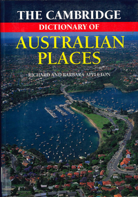
Book, The Cambridge dictionary of Australian Places, 1992
Lists thousands of place names across Australia, giving a detailed account of the name and location, shire etc.maps, pronunciation guidesgazetteer, nomenclature, maps, geography, pronunciation -
 Hume City Civic Collection
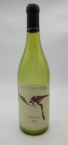
Container - Bottle, wine, LONGVIEW CREEK/SUNBURY, 1994
The bottle was donated to the museum by Ron and Joan Parker for use in the exhibition ' A history of the Vineyards in Sunbury' held in the George Evans Museum in 1996. The vineyard was planted in 1992.Conventional bronze green glass bottle with indented base. Cream, gold & maroon printed labels. On the front there is a map impression of Longview Gorge in Sunbury. On the back there is geographical and historical information about the vineyard. There is black cap with a thin gold band at its base which covers the neck and opening of the bottle.Front label: " LONGVIEW CREEK / SUNBURY / PINOT NOIR / 1994 / Produce of Australia"; " S A A 5300" embossed on the glass around the base of the bottle.wines, wineries, longview creek vineyard, longview gorge, parker, joan, winemakers, hodgson, david, ron, george evans collection, 1990s -
 Nillumbik Shire Council
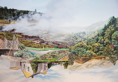
Painting: Kevin CHIN, Kevin Chin, Castle Under the Sky, 2018
This painting was sparked by a US studio residency at Yellowstone National Park, shortly after Trump’s election. In America, Chin witnessed conservative nationalism and divisiveness, but also an equal reaction promoting diversity and challenging structural inequality. Developing this work in Australia, Chin examined how a sense of place forms fluidly in the consciousness, to surpass geographic borderlines.Kevin Chin is a local artist. He has been a finalist in the Nillumbik Prize for Contemporary Art (2015, 2019). In this painting Chin explores economic, cultural and social structures that shape the world in which we live, questioning who has built what, who takes ownership, and who has the right to the land. Landscape painting depicting a house (upside down) and a half finished urban structure sitting amongst mountain peaks and land that has been cleared and immersed in fog/smoke.N/Alandscape, kevin, chin, structural, inequality, castle, trump, painting, nillumbik, residency, yellowstone, realism, oils -
 Koorie Heritage Trust
Book, Giblin, R. W, The early History of Tasmania: the Geographical era 1642-1804, 1928
The history of Tasmania before Australian Federation took place in 1900 may be conveniently divided into three periods which were, by their nature, entirely distinct from the others. Tvhe first of these was the Geographical Era dating from the discovery of the island in 1642 to the years 1803 and 1804, when the first settlements were formed. The second division may be termed the Penal Establishment Era. This last from 1804 to the recall of Lieutenant Governor Arthur in 1836. the final phase might be called the Progressive Era, and was marked by a continuous improvement and development in all the conditions which made for a better social order for the inhabitants of the country.p341; fold-outmaps; illus: appendices; notes; bibliography; chronological tables; index; 22 cm.The history of Tasmania before Australian Federation took place in 1900 may be conveniently divided into three periods which were, by their nature, entirely distinct from the others. Tvhe first of these was the Geographical Era dating from the discovery of the island in 1642 to the years 1803 and 1804, when the first settlements were formed. The second division may be termed the Penal Establishment Era. This last from 1804 to the recall of Lieutenant Governor Arthur in 1836. the final phase might be called the Progressive Era, and was marked by a continuous improvement and development in all the conditions which made for a better social order for the inhabitants of the country.tasmania -- history. | tasmania. -
Koorie Heritage Trust
Book, Department of Pacific and Southeast Asian History, Australian National University, Aboriginal History - Volume 08. 1-2 1984, 1984
This volume of 'Australian History' is devoted to studies of the south-eastern corner of the Australian continent. The papers arose from a series of meetings convened with Professer R. W. Dixon in 1981. They involved scholars from the disciplines listed, all concerned with the south-east. A series of articles by leading writers on Aboriginal History.237 P.; ill,; figs.; tables; notes; reviews; 24 cm.This volume of 'Australian History' is devoted to studies of the south-eastern corner of the Australian continent. The papers arose from a series of meetings convened with Professer R. W. Dixon in 1981. They involved scholars from the disciplines listed, all concerned with the south-east. A series of articles by leading writers on Aboriginal History.aboriginal australians -- periodicals. | ethnology -- australia -- periodicals. | settlement and contacts - colonisation - 1788-1850 | race relations - violent - massacres, murders, poisonings etc. - to 1900 | sex relations | indigenous knowledge - world view | language - personal names | language - semantics | social identity | language - sociolinguistics | government policy - state and territory - new south wales | socioeconomic conditions - living conditions | language - linguistics - language classification | language - vocabulary - word lists | language - linguistics | geography - territories and boundaries | art - rock art - painting | art - production - materials / techniques | art - art motifs | -
Koorie Heritage Trust
Book, Bulmer, John, Victorian Aborigines John Bulmer's Recollections 1855-1908, 1994
... Geographical Society of Australia."` xv, 98 p. : ill., map. figs ...Blurb: " John Bulmer began his missionary work in 1855, commencing a life dedicated to the Christianising of Victorian Aboriginal people at Yelta on the Murray, in the Wimmera and Monaro and at Lake Tyers in Gippsland. ...he recorded many of his recollections in thirteen papers, in correspondence with R. Brough Smyth and A. W. Howitt and in ... Royal Geographical Society of Australia."`xv, 98 p. : ill., map. figs.; tables; notes, word list; bib.;; 25 cm.Blurb: " John Bulmer began his missionary work in 1855, commencing a life dedicated to the Christianising of Victorian Aboriginal people at Yelta on the Murray, in the Wimmera and Monaro and at Lake Tyers in Gippsland. ...he recorded many of his recollections in thirteen papers, in correspondence with R. Brough Smyth and A. W. Howitt and in ... Royal Geographical Society of Australia."`bulmer, john, 1833-1913. | aboriginal australians -- missions -- victoria. | aboriginal australians -- victoria -- social life and customs. | aboriginal australians -- victoria -- social conditions. -
Unions Ballarat
Inside Australia and New Zealand, Gunther, John, 1972
Gunther was an American journalist and author. The "Inside" series of books are continental surveys. Gunther travelled through each geographical area, conducting interviews with a variety of people (politicians, average people, social leaders). The Inside series are his interpretations of these experiences. Relevant to Australian and New Zealand's cultural, political and social profiles circa 1972.Book; paper. Front cover: authors' name and title.ethnography, "inside" series, surveys, interviews, geography, politicians, social history, travel, btlc, ballarat trades hall, ballarat trades and labour council, anthropology -
Unions Ballarat
The tyranny of distance: how distance shaped Australia's history (Don Woodward), Blainey, Geoffrey, 1983
... geography - australia... this. History - Australia. Geography. btlc ballarat trades hall ballarat ...Australian history and how its distant location impacted upon this.History - Australia. Geography.Book; 365 pages. Cover: light grey background; picture of blue globe with a ship; black and red background; author's name and title.Glenn Howard 6C in blue biro.btlc, ballarat trades hall, ballarat trades and labour council, history - australia, geography - australia -
 Numurkah & District Historical Society
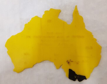
Equipment - Plastic stencil map/shape of Austalia
... high-country education school geography australia stencil ...Yellow plastic stencil in the shape of Australia, states marked on the map, Victoria painted in blackState Savings Bank of Victoraeducation, school, geography, australia, stencil, drawing -
 Numurkah & District Historical Society
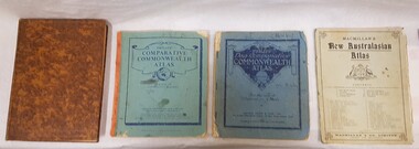
Book - School Atlases, Macmillan's New Australian Atlas / Phillip's New Comparitive Commonwealth Atlas (2) / The New Pictorial Atlas of the World
4 x World Atlas book. Cardboard covers & paper pagessee photoeducation, school, atlas, geography -
 Bendigo Historical Society Inc.
Slide - Bendigo College of Advanced Education - Landscaping, about 1986
Bendigo TAFE is a regional provider of vocational education, training and assessment services, located in northern and central Victoria, Australia. The institute has been in operation in various guises since 1854. The institute was known as the Loddon Campaspe Institute of TAFE from 1987 to 1990, Bendigo Regional Institute of TAFE (BRIT) from 1990 to 2009, before becoming Bendigo TAFE in 2009. Bendigo TAFE services a significant geographical area of approximately 25,000 square kilometres in central and northern Victoria, with a local population of 220,000. In May 2014, Bendigo TAFE announced that it would merge with the Melbourne-based Kangan Institute to form Bendigo Kangan Institute, however both institutes retain their existing branding.Bendigo College of Advanced Education (BCAE) early years - 24 slides of Landscaping at the new premises in Nolan Street Bendigo (Now the Bendigo Tertiary and Further Education (TAFE). history, bendigo, bendigo college of advanced education, bcae, landscaping, bendigo tafe -
 Stawell Historical Society Inc
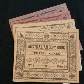
Booklet, Education Department, Australian Copy book
Books used in teaching writing0682-6: Fawn cardboard cover, with complex border artwork. 0682-7: Blue cardboard cover, with complex border artwork. 0682-8: Pink cardboard cover, with complex border artwork. 0682-6: S. Australia. Victoria. N.S. Wales. Queensland. Australian Copy Book Third Class. Medium Hand. Proverbs. Geographical Definitions. Arithmetic. No. 3 Price 2d. W. Australia Tasmania. New Zealand. Melbourne: Published for the Education Department by J. Kemp. Government Printer. 0682-7: Christina (Handwritten) S. Australia. Victoria. N.S. Wales. Queensland. Australian Copy Book Fourth Class. Small Hand. Proverbs. Geography. Commercial Terms. No.4 Price 2d. W. Australia Tasmania. New Zealand. Melbourne: Published for the Education Department by J. Kemp. Government Printer. 0682-8: Angus Cumming (Handwritten) S. Australia. Victoria. N.S. Wales. Queensland. Australian Copy Book Fifth and Sixth Class. Quotations, Poetry & Prose. Commercial. Letters & Forms. No.5 Price 2d. W. Australia Tasmania. New Zealand. Melbourne: Published for the Education Department by J. Kemp. Government Printer.stawell education -
![Painting - Oil on canvas, Paul Lambeth, 'Untitled [from If I belong here ... series]' by Paul Lambeth, 2009](/media/collectors/530576742162ef0fa09a2288/items/534748179821f420f8c03956/item-media/53f59f7b2162f10d4cb03e8f/item-fit-380x285.jpg) Federation University Art Collection
Federation University Art CollectionPainting - Oil on canvas, Paul Lambeth, 'Untitled [from If I belong here ... series]' by Paul Lambeth, 2009
Paul Lambeth was Head of the TAFE Program at the University of Ballarat when this work was undertaken. It formed part of his Master of Arts (Visual Arts) exhibition in 2009. The purpose of Lambeth's study was to contribute a non indigenous perspective to current discourse on sense of place in contemporary Australia. The research employed a number of strategies to investigate current response to our geographic and historical time position. This item is part of the Federation University Art Collection. The Art Collection features over 2000 works and was listed as a 'Ballarat Treasure' in 2007.Abstract paintingSigned verso 'Paul Lambeth '08'art, artwork, paul lambeth, place -
 Vision Australia
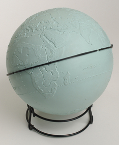
Model - Object, Tactile globe, 1950-1965 approx
Used to teach geographical information, this tactile globe was most likely produced by the RNIB and used at the RVIB Burwood School. Equator is raised and marked in black rubber. Topography land masses and meridians are tactically represented, and includes place names in Braille. A different shade of green is used to represent land masses, and major rivers are shown as well.Green plastic tactile globe with metal stand.Variouseducation aids and devices, rvib burwood school -
 City of Greater Bendigo - Civic Collection
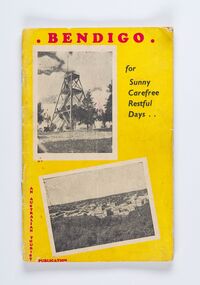
Booklet, Co-operative Press, Bendigo for Sunny Carefree Restful Days, 1947
A promotional publication to attract and encourage tourism to the district. Includes information about geographic location, climate and attractions. Businesses advertising is very eclectic and includes fashion houses, breweries, cafes and the School of Mines and Industry.Thirty six booklet promoting popular sites, events and businesses in Bendigo. Printed in three colour. Right hand page has the slogan BENDIGO "For That Dreamed - of Holiday" with images and text. Left page has full and half page advertisements for businesses, buildings and events.Bendigo / For / Sunny / Carefree / Restful / Days .../ An Australian Tourist / Publicationcity of greater bendigo commerce, city of greater bendigo events, city of greater bendigo tourism, making a nation -
 Mrs Aeneas Gunn Memorial Library
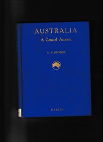
Book, T. Nelson and sons, Australia : a general account - history, resources, production, social conditions, 1929
... - Social life and customs Australia - History Outline of geography ...Outline of geography, European exploration and settlement, economic development, social condition, flora and fauna; includes a brief general account of Aboriginal culture.Index, Ill, maps, p.272.non-fictionOutline of geography, European exploration and settlement, economic development, social condition, flora and fauna; includes a brief general account of Aboriginal culture.australia - social life and customs, australia - history -
 Bacchus Marsh & District Historical Society
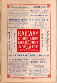
Book, Railway guide book and time table for Melbourne, Ballarat, Adelaide and all intermediate stations, also gazette for Bacchus Marsh, Ballan, Melton, &c., and almanac for 1891
Publication details: 'Railway guide book and time table for Melbourne, Ballarat, Adelaide and all intermediate stations, also gazette for Bacchus Marsh, Ballan, Melton, &c., and almanac for 1891', compiled by Christopher Crisp. Printed and published by Crisp and Lane, Bacchus Marsh, Vic., 1891. SUMMARY OF CONTENT: Includes detailed timetables and schedule of fares, descriptions of stations and refreshment facilities pp.6-26; overviews of Shires of Bacchus Marsh, Ballan and Melton, pp.27-30; historical, geographic, and economic background notes about places on the Melbourne to Adelaide route, pages 31-64, including descriptions of Bacchus Marsh, pp.34-42 and briefer notes on Ballan, pp.42-43 and Melton, pp.32-33. Almanac section is pp.65-95 (not numbered), containing common information in nineteenth century almanacs such as a calendar of the days, weeks, and months of the year; a record of various astronomical phenomena, climate information and seasonal suggestions for farmers, the rising and setting times of the Sun and Moon, dates of eclipses, hours of high and low tides, and religious festivals. A brief history of Irrigation in Mildura is on pages 1 and 112 (first and last pages). Advertisements, mostly for Bacchus Marsh businesses are on pp.96-111. The Almanac section is illustrated with drawings of scenic views of various places in Australia, but none of the Bacchus Marsh region. Online access is available on Trove at: http://nla.gov.au/nla.obj-392504046Printed book. 112 pages in total. Pages 13 -64 numbered.non-fictionPublication details: 'Railway guide book and time table for Melbourne, Ballarat, Adelaide and all intermediate stations, also gazette for Bacchus Marsh, Ballan, Melton, &c., and almanac for 1891', compiled by Christopher Crisp. Printed and published by Crisp and Lane, Bacchus Marsh, Vic., 1891. SUMMARY OF CONTENT: Includes detailed timetables and schedule of fares, descriptions of stations and refreshment facilities pp.6-26; overviews of Shires of Bacchus Marsh, Ballan and Melton, pp.27-30; historical, geographic, and economic background notes about places on the Melbourne to Adelaide route, pages 31-64, including descriptions of Bacchus Marsh, pp.34-42 and briefer notes on Ballan, pp.42-43 and Melton, pp.32-33. Almanac section is pp.65-95 (not numbered), containing common information in nineteenth century almanacs such as a calendar of the days, weeks, and months of the year; a record of various astronomical phenomena, climate information and seasonal suggestions for farmers, the rising and setting times of the Sun and Moon, dates of eclipses, hours of high and low tides, and religious festivals. A brief history of Irrigation in Mildura is on pages 1 and 112 (first and last pages). Advertisements, mostly for Bacchus Marsh businesses are on pp.96-111. The Almanac section is illustrated with drawings of scenic views of various places in Australia, but none of the Bacchus Marsh region. Online access is available on Trove at: http://nla.gov.au/nla.obj-392504046railways, railway lines, almanacs, railway lines timetables -
 Kilmore Historical Society
Book, Baron Ferdinand von Mueller, SYSTEMATIC CENSUS OF AUSTRALIAN PLANTS. Part 1. - Vasculares, 1882
Systematic Census of Australian Plants with Chronologic, Literary and Geographic Annotations.Paper cover, stained, foxing, insect damage to extremities. Cloth strip to spine, tearing at top and bottom. 152 pp. Binding generally intact, pp 51-54 detached. Sewn binding shows metallic/rust staining. Pages generally clean & unmarked throughout. Fair condition.non-fictionSystematic Census of Australian Plants with Chronologic, Literary and Geographic Annotations.botany, australia -
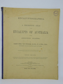 Kilmore Historical Society
Book, Baron Ferdinand von Mueller et al, EUCALYPTOGRAPHIA. Tenth Decade, 1884
A descriptive atlas of the Eucalypts of Australia and adjoining islands. This last part of the series also contains a Synopsis of the Species, Geographic Index, Index of Vernacular Names, Index of Decades and Alphabetical Index.Light card cover with blue cloth backstrip to spine, torn at upper extremity. Some staining and marks on cover, discoloration from light exposure. Some foxing through out. Binding intact. Fair condition.non-fictionA descriptive atlas of the Eucalypts of Australia and adjoining islands. This last part of the series also contains a Synopsis of the Species, Geographic Index, Index of Vernacular Names, Index of Decades and Alphabetical Index.botany, eucalypts, australia -
 Wodonga & District Historical Society Inc
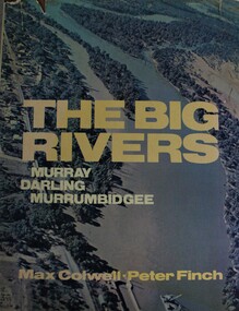
Book - The Big Rivers: Murray Darling Murrumbidgee, Max Colwell, 1978
... south australia A geography, description and travel guide ...A geography, description and travel guide to the "Big Rivers" of the Murray- Darling basin, including many photos of the region.non-fictionA geography, description and travel guide to the "Big Rivers" of the Murray- Darling basin, including many photos of the region.murray river (n.s.w.-s.a.), murray river valley, darling river, murrumbidgee river, description and travel nsw, description and travel south australia -
 Mrs Aeneas Gunn Memorial Library
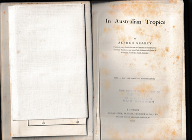
Book, Kegan Paul Trench Trubner and Co, In Australian tropics, 1907
Early history of N.T. and explorations; Detailed account of intercepting Macassan proas around coast of Arnhem Land whilst author was Sub-Collector of Customs for 14 years; Names of proas and masters, Malay camps & smoke houses along coast & nearby islands; Natives employed by Malays in trepang fishing and collecting tortoiseshell, relationships between Malays and Aborigines; influences (physical & cultural); Habit of exchanging children between tribes (Roper R. & Normanton) for the purpose of learning each others language & customs; Description of native camps at Fort Dundas (1895) shelters, finding of bark water bags, types of canoes used; Platform burial at Daly R.; Sacred burial site on Maria Island; Geographical features, vegetation, climate etc., general ecology, depredations & murders by natives; Cannibalism practiced by Fitzmaurice River tribes.Ill, maps, p.373.non-fictionEarly history of N.T. and explorations; Detailed account of intercepting Macassan proas around coast of Arnhem Land whilst author was Sub-Collector of Customs for 14 years; Names of proas and masters, Malay camps & smoke houses along coast & nearby islands; Natives employed by Malays in trepang fishing and collecting tortoiseshell, relationships between Malays and Aborigines; influences (physical & cultural); Habit of exchanging children between tribes (Roper R. & Normanton) for the purpose of learning each others language & customs; Description of native camps at Fort Dundas (1895) shelters, finding of bark water bags, types of canoes used; Platform burial at Daly R.; Sacred burial site on Maria Island; Geographical features, vegetation, climate etc., general ecology, depredations & murders by natives; Cannibalism practiced by Fitzmaurice River tribes. northern australia - description and travel, ethnography -
 Mrs Aeneas Gunn Memorial Library
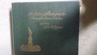
Book, Werner Co, Portfolio of photographs of famous scenes, cities and paintings : containing a rare and elaborate collection of photographic views of the entire world of nature and art, presenting and describing the choicest treasures of Europe, Asia, Africa, Australia, North and South America, the Old World and the New, 189?
A collection of photographs from around the worldIll, p.196.non-fictionA collection of photographs from around the worldgeography - pictorial works, photography -
Lakes Entrance Historical Society
Book, Mc Intyre Alan J M Lawton G, Longmans Australia Geographies Gippsland No 10, 1958
... students. Longmans Australia Geographies Gippsland No 10 Book Mc ...Basic information about Gippsland geography agriculture and industries written for school students.agriculture, industrial, topography -
 Bendigo Historical Society Inc.
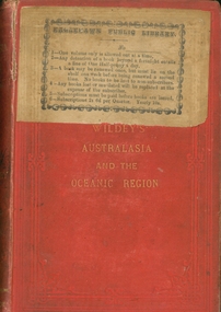
Book - AUSTRALASIA AND THE OCEANIC REGION, 1876
Wildey's Australasia and the Oceanic Region by William Brackley Wildey, red hard cover with gold lettering, sticker on front Eaglehawk Public Library, 426 pages with information about Australia. Published by George Robertson, printed by Ferguson and Moore Melbourne.australasia, william wildey, geography, history -
 Falls Creek Historical Society
Booklet - Australian Ski Year Book 1981 Resort Guide
"The Australian Ski Year Book" was first published in 1928 by the Kosciusko Alpine Club and the Ski Club of Australia, which with the Kiandra Ski Club, were the oldest organisations for skiing in Australia. In later years organisations from Victoria, Tasmania and New Zealand were included. It was published on behalf of N.S.W. Ski Council, Ski Club of Victoria, Ski Council of Tasmania, Ski Council of the Federated N.Z. Mountain Clubs. It aimed to provide an annual record of the sport of ski running in Australia, and of events elsewhere which would be of interest to Australian ski enthusiasts. This publication was a guide to all major resorts operation at the time in New South Wales, Victoria and Tasmania. Information about Falls Creek included a description of its location describing geographical features, its 12 ski tows and available services. The accommodation advertised included Winterhaven Lodge, Falls Creek Motel, Spargo's Lodge, Attunga Alpine Lodge, Nelse Alpine Lodge, Les Chalets, Julian Lodge and Koki and Karelia Alpine Lodges.This item is significant because it is an issue of a long-running Australian ski publication which includes items about Falls Creek, Victoria..The Australian Ski Year Book Resort Guide of 1981 includes information and advertising about resorts throughout Australia. Falls Creek information and Accommodation Guide featured on pages 10 & 11 of this issue.australian skiing, accommodation falls creek, falls creek resort -
 The Beechworth Burke Museum
Geological specimen - Fossil Leaves
A fossil refers to any remains or traces of past life that are preserved in the rock. It could be remains of plants or animals. Fossil leaves are commonly found on different types of rocks. These fossils can go as far back as the Triassic Age just like the series of fossil plants collected at Denmark Hill, Ipswich in Queensland. Fossils leaves are formed when dead plants get buried by sediments like mud, sand, or volcanic ash. Often, it gets detached cleanly from stems along a special layer of weak cells, then twigs, and, less commonly, cones of conifers and fruits and seeds of flowering plants. Over time, the leaves or pieces of leaves get buried by more sediments and eventually gets 'lithified' or hardened into a rock. Erosions and mining can cause the rocks to break and reveal the fossils buried in it. Fossilisation frequently takes place at sites in the lowlands where deposits of clay, silt, sand are found. This is usually due to weathering and erosion of rocks. Fossil leaves can provide information about ancient Australia's way of living. It contributes to Victorian biodiversity records and its botanical collections. It also contributes information on the geographical profile of Victoria as fossilisation usually occur at estuaries and deltas of rivers, river flood plains, ponds and lakes. This specimen is part of a larger collection of geological and mineral specimens collected from around Australia (and some parts of the world) and donated to the Burke Museum between 1868-1880. A large percentage of these specimens were collected in Victoria as part of the Geological Survey of Victoria that begun in 1852 (in response to the Gold Rush) to study and map the geology of Victoria. Collecting geological specimens was an important part of mapping and understanding the scientific makeup of the earth. Many of these specimens were sent to research and collecting organisations across Australia, including the Burke Museum, to educate and encourage further study.Piece of light brown rock with fossilised leaves in shades of golden yellow and brown.Existing label: Fossil Leaves / Locality unknown / might be worth checking if this is Glossopteris, a Permian age plant. / C. William 16/4/21 geological specimen, geology, geology collection, burke museum, beechworth, fossil leaves, fossilization, 1868 geological survey of victoria, lithified, rocks, fossilised leaf, rock, fossils, leaves