Showing 720 items matching "bible street"
-
 Eltham District Historical Society Inc
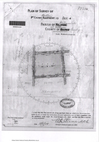
Document - Photocopy, Survey Fleld Notes of Part of Crown Portion 13, Section 4 at Eltham, Parish of Nillumbik, County of Evelyn, 18 May 1908
... Bible Street...Portion of land bounded by: Main Road, Luck Street, Bible... melbourne Portion of land bounded by: Main Road, Luck Street, Bible ...Portion of land bounded by: Main Road, Luck Street, Bible Street, Arthur Street Application 37314 W. P. Steane, M.C.E. Civil Engineer and Surveyor, 18 May 1908application 37314, arthur street, bible street, eltham, luck street, main road, map, survey plan -
 Eltham District Historical Society Inc
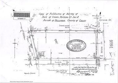
Document - Photocopy, Survey Fleld Notes of Part of Crown Portion 13, Section 4 at Eltham, Parish of Nillumbik, County of Evelyn, 7 January 1924
... Bible Street..., Bible Street Application 9991 R. Woodstock, Land Surveyor, 7..., Bible Street Application 9991 R. Woodstock, Land Surveyor, 7 ...Portion of land north of Luck Street bounded by: Main Road, Bible Street Application 9991 R. Woodstock, Land Surveyor, 7 January 1924application 9991, bible street, eltham, luck street, main road, map, survey plan -
 Eltham District Historical Society Inc
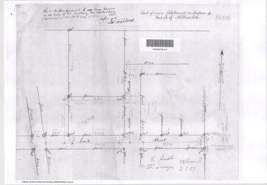
Document - Photocopy, Survey Fleld Notes of Part of Crown Portion 13, Section 4 at Eltham, Parish of Nillumbik, County of Evelyn, 31 May 1907
... Bible Street... bounded by Bible Street Application 36708 K. Arndt, Licensed... bounded by Bible Street Application 36708 K. Arndt, Licensed ...Portion of land east of Main Road and north of Luck Street bounded by Bible Street Application 36708 K. Arndt, Licensed Surveyor, 31 May 1907application 36708, bible street, eltham, luck street, main road, map, survey plan -
 Eltham District Historical Society Inc
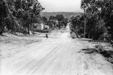
Photograph, Brougham Street, Eltham, c. Sep. 1966
... bible street... walking up the road and past him a truck turning right into Bible... road construction roads bible street Originally located ...Taken from near No. 113 looking west. There is a boy walking up the road and past him a truck turning right into Bible Street. Further down the road near the EK Holden is a Eucalyptus tree with branch overhanging the road that still stands today (2021) outside No. 102.Black and white photographic printOriginally located in a Filmpro King Size Prints processing envelope $3.01 Shire of Eltham 9/9/66 and noted as Calrossie Ave area and crossed out Eltham-Yarra Glen Road, Bridge Street to Elsa Court existing conditions mid 1967brougham street, eltham, infrastructure, road construction, roads, bible street -
 Eltham District Historical Society Inc
Negative - Photograph, Eltham, Vic, c.1890
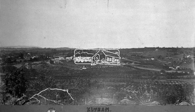
... Bible Street... on Bible Street. In the foreground are orchards running up... on Bible Street. In the foreground are orchards running up ...View looking northeast from present day Ely Street (near intersection of present day Cronus Court and Porter Street) across what will become the site of Eltham High School towards Main Road showing the Eltham Courthouse and Police station. View is very similar to the sketch of Eltham published in 'The Illustrated Australasian News', December 26, 1884, p212. Note the large bluestone cell block behind police house and stable. George Knapman's Shoeing Forge next to the courthouse and the concentration of buildings around the Evelyn Hotel and Watson's Eltham Hotel on opposite sides of Main Road at Pitt street. Also note George Stebbing's cottage (c.1860) on Pitt Street behind the courthouse and 'Sunnyside' (home of W.J. Taylor built c.1885) at the top of the hill on Bible Street. In the foreground are orchards running up to the main street, Maria Street and also between Brougham Street and Dalton Street bordered by Bible Street.This photo forms part of a collection of photographs gathered by the Shire of Eltham for their centenary project book,"Pioneers and Painters: 100 years of the Shire of Eltham" by Alan Marshall (1971). The collection of over 500 images is held in partnership between Eltham District Historical Society and Yarra Plenty Regional Library (Eltham Library) and is now formally known as the 'The Shire of Eltham Pioneers Photograph Collection.' It is significant in being the first community sourced collection representing the places and people of the Shire's first one hundred years.Digital image 4 x 5 inch B&W Negshire of eltham pioneers photograph collection, eltham, 1890, bible street, brougham steet, dalton street, eltham courthouse, eltham hotel, evelyn hotel, franklin street, grant house, knapmans forge, main road, maria street, orchards, police residence, police station, pre 1900, stebbing cottage, sunnyside, w.b. andrew corn store, watsons hotel, little eltham -
 Eltham District Historical Society Inc
Photograph, Fay Bridge, Flood damage at Nillumbik Medical Centre, 1078 Main Road, Eltham, 26 December 2011
... Bible Street Reserve... flooding houses, through the Bible Street Reserve where... flooding houses, through the Bible Street Reserve where ...Flood damage resulting from a late afternoon storm on Christmas Day 2011. A flash flood occurred from significant rain fall and hail, which accumulated along an old waterway with floodwater submerging cars along Valonia Drive then down Grove Street flooding houses, through the Bible Street Reserve where it then submerged Main Road washing away the small railway trestle bridge opposite the reserve then flooding the Judge Book Village before finally entering the Diamond Creek..fay bridge collection, 2011-12-26, bible street reserve, flood damage, floods, floodwater, main road, nillumbik medical centre -
 Eltham District Historical Society Inc
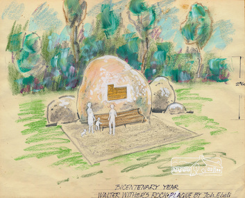
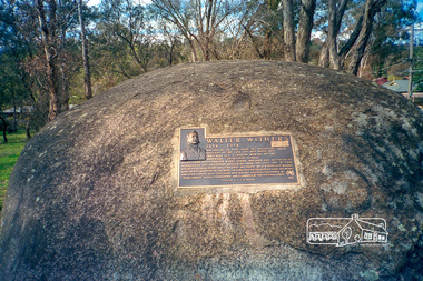
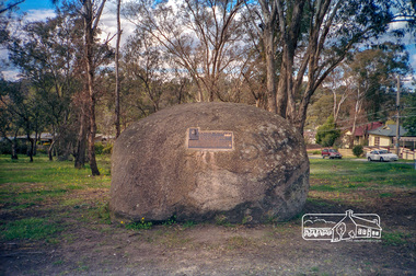
Sketch (Concept), Joh Ebeli, Bicentenary Year Walter Withers Rock and Plaque Design by Joh. Ebeli (1988), 1988
... bible street... and Bible Streets, Eltham. The rock was installed 17 May 1990... and Bible Streets, Eltham. The rock was installed 17 May 1990 ...Concept sketch for the placement of a commemorative plaque on a rock in the Walter Wither Reserve at the corner of Arthur and Bible Streets, Eltham. The rock was installed 17 May 1990. Russell Yeoman advised (14 Jun 2017 society meeting) that the Shire of Eltham had been given a plaque to commemorate Walter Withers and that the rock was sourced from west of Melbourne with funds from a local government grant. The initial crane to lift the rock in place was too small and another crane was arranged. This also proved too small to lift it until a third and larger crane was arranged. Mary Owen, granddaughter of Walter Withers unveiled the commemorative plaque at a ceremony held at Walter Withers Reserve at the corner of Bible and Arthur Streets, Eltham, 13 Oct 1990.Colour pencil and wash on paper mounted on card and sealed at edges with masking tape. Protective facing sheet also attached with masking tape."Rock and Plaque design" on facing sheet On back: "John Ebeli 63 Batman Rd Eltham"eltham, walter withers reserve, walter withers rock, shire of eltham, arthur street, bible street, joh ebeli, design, plaques -
 Eltham District Historical Society Inc
Photograph - Aerial Photograph, Landata, Eltham, Vic, Apr. 1972
... Bible Street... bounded by Progress Road to north, Brougham Street to south, Bible... bounded by Progress Road to north, Brougham Street to south, Bible ...Centred on present day Ryans Road at Sandra Avenue, Eltham bounded by Progress Road to north, Brougham Street to south, Bible Street to east and Outlook Crescent to west. Historic Aerial Imagery Source: Landata.vic.gov.au Aerial Photo Details: Project No :985 Project : MELBOURNE 1972 Run : 27 Frame : 48 Date : 04/1972 Film Type : B/W Camera : RC10 Flying Height : 5700 Scale : 9600 Film Number : 2636 GDA2020 : 37°42'41"S, 145°08'38"E MGA2020 : 336392, 5824574 (55) Melways : 21 H4 (ed. 42)aerial photo, neil webster collection, 1972-04, eltham, bible street, brougham steet, melway 21h4, outlook crescent, progress road, ryans road, sandra avenue, montmorency -
 Eltham District Historical Society Inc
Photograph - Aerial Photograph, Landata, Eltham, Vic, Apr. 1972
... Bible Street..., Reynolds Road to east and Bible Street to west. Historic Aerial..., Reynolds Road to east and Bible Street to west. Historic Aerial ...Centred on present day Mays Road at Stringybark Road, Eltham bounded by Nyora Road to north, Yarra River to south, Reynolds Road to east and Bible Street to west. Historic Aerial Imagery Source: Landata.vic.gov.au Aerial Photo Details: Project No :985 Project : MELBOURNE 1972 Run : 28 Frame : 209 Date : 04/1972 Film Type : B/W Camera : RC10 Flying Height : 5700 Scale : 9600 Film Number : 2635 GDA2020 : 37°43'33"S, 145°09'28"E MGA2020 : 337647, 5823013 (55) Melways : 22 B8 (ed. 42)aerial photo, neil webster collection, 1972-04, eltham, bible street, mays road, melway 22b8, nyora road, reynolds road, stringybark road, yarra river -
 Eltham District Historical Society Inc
Photograph - Aerial Photograph, Landata, Eltham, Vic, Apr. 1963
... Bible Street... bounded by Elsa Court to north, Main Road to south, Bible Street... bounded by Elsa Court to north, Main Road to south, Bible Street ...Centred on present day Eltham Ridge, Bolton Street, Eltham bounded by Elsa Court to north, Main Road to south, Bible Street to east and Reichelt Avenue and Rattray Road to west. Historic Aerial Imagery Source: Landata.vic.gov.au Aerial Photo Details: Project No :486 Project : MELBOURNE (1963) PROJECT Run : 6 Frame : 124 Date : 04/1963 Film Type : B/W Camera : RC8 Flying Height : 5100 Scale : 9600 Film Number : 1805 GDA2020 : 37°43'12"S, 145°08'16"E MGA2020 : 335876, 5823604 (55) Melways : 21 G6 (ed. 42)aerial photo, neil webster collection, 1963-04, bible street, bolton street, eltham, eltham ridge, main road, montmorency, rattray road, reichelt avenue -
 Eltham District Historical Society Inc
Photograph - Aerial Photograph, Landata, Montmorency, Feb. 1956
... Bible Street... and Eltham Lower Park to south, Bible Street to east and Para Road... and Eltham Lower Park to south, Bible Street to east and Para Road ...Centred on present day Grand Boulevard and Olympic Way, Montmorency bounded by Diamond Street to north, Old Eltham Road and Eltham Lower Park to south, Bible Street to east and Para Road to west. Historic Aerial Imagery Source: Landata.vic.gov.au Aerial Photo Details: Project No :250 Project : MELBOURNE OUTER SUBURBS PROJECT Run : 17 Frame : 115 Date : 02/1956 Film Type : B/W Camera : EAG9 Flying Height : 10000 Scale : 12000 Film Number : 1176 GDA2020 : 37°43'24"S, 145°07'55"E MGA2020 : 335375, 5823236 (55) Melways : 21 F7 (ed. 42)aerial photo, 1956-02, neil webster collection, eltham, main road, montmorency, bible street, diamond street, eltham lower park, grand boulevard, melway 21f7, old eltham road, olympic way, para road -
 Eltham District Historical Society Inc
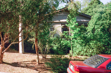
Photograph, George Coop, Carrucan's Dairy on Dalton Street, Eltham, c.1969, 1969
... Bible Street, Carrucan dairy, Carrucan home, Dalton Street... on Dalton Street. An unmade Bible Street can be seen running down... on Dalton Street. An unmade Bible Street can be seen running down ...Viewed from intersection of Mount Pleasant Road and Metery Road looking northwest. The dairy is in the foreground situated on Dalton Street. An unmade Bible Street can be seen running down the hill at the left to intersect with Dalton Street. Dalton Street runs from left to right between the dairy and the Carrucan family home opposite located on the southeast corner of Bible and Dalton streets. Doug Orford recalls the dairy was at a slight angle to Dalton Street. Tim Erickson, (a nephew to Betty Erickson, nee Carrucan) reacalled (9 May 2025): the bottom front paddock ran from MeteryRoad to Mount Pleasant Road The brick dairy from 1thje 1950s had 10-15 milking cow , Jersey and Guernsey6 and the used to send the cream to Eltham Dairy The garage when Tim was a child used to house a couple of sulkies The laundry was a local home built job The small house built late 1940s for Betty Carrucan for her family The small orchard grew Quince, Apple and Plum The main block was the upper paddock Cypress trees remain present as of 2025 Originally 2 buildings but a third was added in the early 1900s for a kitchen and diningDigital TIFF file Scan of 35mm Ilford HP4 black and white transparencybible street, carrucan dairy, carrucan home, dalton street, eltham, mount pleasant road -
 Eltham District Historical Society Inc
Photograph, 90 Brougham Street, Eltham, c.1999, 19989
... Bible Street, Eltham, Victoria ...Streetscape evolutionRoll of 35mm colour negative film, 6 stripsAgfa HDC 200 plus-2houses, streets, eltham, brougham street -
 Eltham District Historical Society Inc
Photograph, Peter Pidgeon, 6 Grove Street, Eltham, 20 May 2017, 20 May 2017
... Bible Street, Eltham, Victoria, Australia ...Streetscape changesBorn Digitaleltham, grove street -
 Eltham District Historical Society Inc
Photograph, Peter Pidgeon, 6 Grove Street, Eltham, 20 May 2017, 20 May 2017
... Bible Street, Eltham, Victoria, Australia ...Streetscape changesBorn Digitaleltham, grove street -
 Eltham District Historical Society Inc
Photograph, Peter Pidgeon, 6 Grove Street, Eltham, 20 May 2017, 20 May 2017
... Bible Street, Eltham, Victoria, Australia ...Streetscape changesBorn Digitaleltham, grove street -
 Eltham District Historical Society Inc
Photograph, Peter Pidgeon, 6 Grove Street, Eltham, 20 May 2017, 20 May 2017
... Bible Street, Eltham, Victoria, Australia ...Streetscape changesBorn Digitaleltham, grove street -
 Eltham District Historical Society Inc
Photograph, Peter Pidgeon, 6 Grove Street, Eltham, 20 May 2017, 20 May 2017
... Bible Street, Eltham, Victoria, Australia ...Streetscape changesBorn Digitaleltham, grove street -
 Eltham District Historical Society Inc
Postcard - Photograph postcard, Panorama at Eltham, Vic, c.1923
... Bible Street... at the top of the hill in Bible Street. Only three residences... at the top of the hill in Bible Street. Only three residences ...The Rose Series P. 4284 post card Taken from near what would be present day CLC car park looking southwest across Diamond Street, present-day Andrew Park to the railway station and developing Eltham shopping precinct. Arthur Street visible, Pryor and Luck Street not evident. Sunnybrook, the Taylor home is visible at the top of the hill in Bible Street. Only three residences visible in Arthur Street on the southern side, two of these are the David Harbison Rest Home at 10 and 12 Arthur Street (built and opened in November 1919), present day site of Eltham Mall. There are none on the north side of the street. Based on 1945 aerial view there are 8 buildings on the northern side between Main Road and Bible Street which and given the extent of commercial development on Main Road, it is estimated this image is circa 1925. Luther Haley was the first to build an open a baker and General Store in this location next to the railway station in 1902. However, it took nearly twenty years until the early to mid-1920s when a period of significant growth in the Eltham shopping centre happened with many businesses relocating their operations from the original town centre of Maria Street in Little Eltham as well as new businesses opening. Other stores/buildings noted (L-R) are: Stationmaster's House built circa 1910 Eltham Hardware Store opposite the railway station first opened on Main Road opposite the Railway Station around late 1922. An advertisement placed in the Hurstbridge Advertiser advised that the Hardware Store had just opened with a varied stock of Saws, Hammers, Nails, Shovels, Screw Drivers, and every article required in a house or on a farm. People were also encouraged to try their Jams, Pickles, Sauces, Cups and Saucers, etc. Newsagency with 'Leader' advertising on awning - E. J. Andrew opened his newsagency shop opposite the station in March 1923, advertising for sale stationery, school requisites and periodicals. Bird Brothers Cash Grocer & Fruiterer opposite the railway station offering summer drinks and confectionery a specialty with a full Stock of groceries of the best quality always on hand at city prices opened December 1921 William Capewell's Butcher shop at the corner of Dudley Street. Capewell previously had a small shop in front of the station opposite Luck Street. He enlisted in the AIF during WW1 and returned home in 1919. He re-applied for a slaughtering license in February 1920 and was advertising by October 1922 supplying all districts. Not visible (or not yet identified) but in business by October 1922 were: J.H. Fraser, Carpenter and Builder at Luck Street opposite the station George A. Danslow, Hairdresser and Tobacconist opposite the railway station Miss Barber's 'Blue Gum' Soda Fountain opened October 1922 opposite the railway station (hidden behind Stationmaster's House). It was so named due to its proximity to a tall Blue Gum tree G.H. McDonald Boot Repairer opposite the railway station In December 1923 the first portion of the main street to be formed from Dudley to Arthur streets was almost completed. This is the section in front of Capewell's Butcher shop though it is difficult to fully make out from the photoDigital file only Postcards scanned from the collection of Michael Aitken on loan to EDHS, 2 Sep. 2022michael aitken collection, eltham, postcards, arthur street, david harbison rest home, electrine candles, eltham railway station, eltham shopping centre, lloyd's general store, red rattler, rose series postcard, rose stereograph company, tait train, velvet soap, andrew park, bible street, bird brothers cash grocer & fruiterer, bird brothers cash grocer and fruiterer, butcher, diamond street, dudley street, eltham hardware and timber, eltham hardware store, eltham mall, main road, station masters house, stationmaster's house, sunnybrook, w.j. capewell, w.j. capewell butcher shop -
 Eltham District Historical Society Inc
Photograph - Aerial Photograph, Landata, Eltham, Main Road; Henry St to Bellevue Rd, Dec. 1945
... Bible Street... Bible Street Diamond Street Dudley Street Elsa Court Eltham ...Eltham, Main Road; Henry St to Bellevue Rd, and east along Luck St to present day Eltham East School Historic Aerial Imagery Source: Landata.vic.gov.au Aerial Photo Details: Project No :5 Project : MELBOURNE AND METROPOLITAN AREA PROJECT Run : 36 Frame : 60549 Date : 12/1945 Film Type : B/W Camera : EAG4 Flying Height : 10200 Scale : 6000 Film Number : 228 GDA2020 : 37°42'45"S, 145°08'59"E MGA2020 : 336903, 5824465 (55) Melways : 21 K4 (ed. 42)aerial photo, arthur street, bellevue road, bible street, diamond street, dudley street, elsa court, eltham, eltham east primary school, gahan house, henry street, livingstone road, luck street, main road, pryor street, neil webster collection -
 Eltham District Historical Society Inc
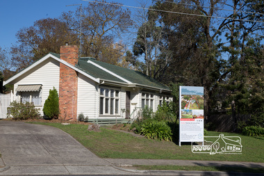
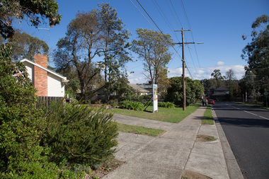
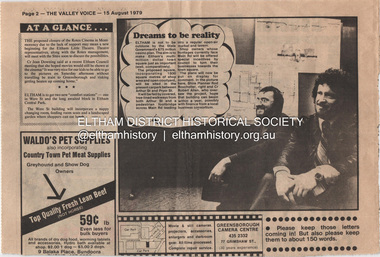
Document - Property Binder, Eltham Town Square, Commercial Place, Eltham
... Bible Street... of Eltham March 1994 Businesses Arthur Street Bible Street ...1. Dreams to be reality, The Valley Voice, 15 August 1979, p2 - announcement of proposed town square of 1800 square metres of shop area and open courtyard to be sited in the carpark between Arthur Street and Pryor street. The plans also included tree-lined walkways from both Arthur Street and a pededstrian footbridge across Main Road leading to aregular open-air market and tavern. Shop owners facing Main Road were to be encouraged to turn their businesses towards the square. On reverse side - 'General' Marshall and his troops; Valley votes in five new faces, The Valley Voice, 15 August 1979, p1 - picture showing newly elected Cr Robert Marshall 2. Square plan on display, Diamond Valley News, Tuesday, June 23, 1981, p1 - Council's prefered proposal on display to the public. On same page a story about the son of Cr Bob Manuell being attacked on the train from the city. On reverse side - Helping people - here and abroad by Marguerite Marshall, Diamond Valley News, Tuesday, June 23, 1981, p2 - about Keith Ryall of Zig Zag Road, the Apex international councillor for Australia 3. Plan: Eltham Town Centre property Acquisition, Shire of Eltham March 1994businesses, arthur street, bible street, commercial place, dudley street, eltham, franklins supermarket, luck street, main road, map, mcewans, pryor street, safeway supermarket, apex club, bronwyn ryall, keith ryall, zig zag road, cr bob manuell, cr robert allen, det sgt noel murphy, eltham chamber of commerce, eltham police, eltham shire council, eltham town square, lorraine manuell, pauline toner mp, robert manuell, rodney roscholler, shire planner, vicrail, elections, h&j white general store, hurstbridge, leslie bowker, main street, mrs marshall, pam lawson, robert marshall, rosemary tovey, central park, comfort station, eltham little theatre, montmorency, public toilets, rotex cinema, were street -
 Eltham District Historical Society Inc
Photograph, Peter Pidgeon, Site of former Eltham Tennis Court, Wingrove Park, 2 Aug. 2022
... Bible Street... photographer J.H. Clark Bible Street Eltham J.H. Clark Photo (2022 ...View looking through Wingrove Park from near the Diamond Creek Trail towards the Coles Express Service Station and Mount Pleasant Road intersection. Comparison photo: SEPP_0720 Eltham Tennis Court, c.1909 and SEPP_0721 - Eltham Tennis Court, Lady Premiers 1909-1910 The tennis courts were located in Bremner’s Flats, present day Wingrove Park. The Eltham Lawn Tennis Club was formed on a Saturday evening, the 29th of October, 1898 at a meeting held at the Eltham State school. Twenty members were enrolled, and eight more shortly afterwards. Officers and a committee were duly elected, and the Treasurer was instructed to purchase the necessary requisites without delay. By the end of the first week in November all the requisites were to hand, two courts were marked out, and practice begun. The formal opening of the Courts of this Club took place on Saturday, November 12, 1898, when 26 members and their friends assembled. Part of a presentation by Peter Pidgeon to the Society, 13 August 2022 showcasing a series of photographs taken by John Henry Clark over the period 1895 to 1930. John Henry Clark was the youngest of three boys born to William Henry Clark (1823-1877) and Maria White (1843-1914). He and his brothers, William Charles Clark (1872-1945), Clement Kent Clark (1874-1912) operated a photography business (Clark Bros.) from 25 Thomas Street, Windsor near Prahran during the period c.1894 to 1914. Following death of Clement in September 1912 and their mother in 1914, the Clark Bros business appears to have dissolved, the premises demolished, and a new house was under construction in 1915. John set up business independently in 1914 operating out of 29 Moor Street, Fitzroy where he is registered in the 1914 and 1915 Electoral Rolls. By 1916 John had relocated to Eltham where he continued his practice as a photographer and took many of the early images around the district of Little Eltham. Around 1930 John changed professions and opened a small cobbler's shop in 1931 near the pond opposite Dalton Street adjacent to the Jarrold family cottage. He never married and continued his profession as a bootmaker from this little shop, maintaining a close relationship with Mrs Jarrold for the rest of their lives. His bootmaker shop remains today beside the Whitecloud cottage and is one of only three remaining shops in the area from the early 20th century.Comparative photo taken 2022 with one taken from same location over 100 years earlier by noted local photographer J.H. ClarkBorn Digitalbible street, eltham, j.h. clark photo (2022), bremner's flat, eltham lawn tennis club, eltham tennis court, main road, mount pleasant road, tennis court, wingrove park -
 Eltham District Historical Society Inc
Photograph, Peter Pidgeon, Main Road, Eltham, 2 Aug. 2022
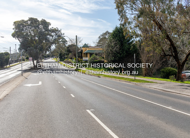
... Bible Street Reserve... Street Bible Street Reserve Born Digital Main Road, Eltham ...Comparison photo: SEPP_0619 Part of a presentation by Peter Pidgeon to the Society, 13 August 2022 showcasing a series of photographs taken by John Henry Clark over the period 1895 to 1930. John Henry Clark was the youngest of three boys born to William Henry Clark (1823-1877) and Maria White (1843-1914). He and his brothers, William Charles Clark (1872-1945), Clement Kent Clark (1874-1912) operated a photography business (Clark Bros.) from 25 Thomas Street, Windsor near Prahran during the period c.1894 to 1914. Following death of Clement in September 1912 and their mother in 1914, the Clark Bros business appears to have dissolved, the premises demolished, and a new house was under construction in 1915. John set up business independently in 1914 operating out of 29 Moor Street, Fitzroy where he is registered in the 1914 and 1915 Electoral Rolls. By 1916 John had relocated to Eltham where he continued his practice as a photographer and took many of the early images around the district of Little Eltham. Around 1930 John changed professions and opened a small cobbler's shop in 1931 near the pond opposite Dalton Street adjacent to the Jarrold family cottage. He never married and continued his profession as a bootmaker from this little shop, maintaining a close relationship with Mrs Jarrold for the rest of their lives. His bootmaker shop remains today beside the Whitecloud cottage and is one of only three remaining shops in the area from the early 20th century.Comparative photo taken 2022 with one taken from same location over 100 years earlier by noted local photographer J.H. ClarkBorn Digitaleltham, j.h. clark photo (2022), main road, cecil street, bible street reserve -
 Eltham District Historical Society Inc
Album - Photograph, J.A. McDonald, Cecil Street Bridge, Eltham-Yarra Glen Road, Eltham, Oct. 1962
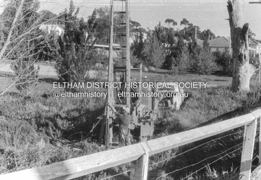
... Bible Street Reserve...-10 Bible Street Reserve Cecil Street Bridge Eltham Eltham ...Eltham-Yarra Glen Road Cecil Street Bridge Looking upstream Oct. 1962Record of various Shire of Eltham infrastructure works undertaken during the period of 1952-1962 involving bridge and road reconstruction projects, sometimes with Eltham Shire Council Project Reference numbers quoted. It was during this period that a number of significant improvements were made to roads and new bridges constructed within the shire that remain in place as of present day (2022). In many situations, the photos provide a tangible visible record of infrastructure that existed throughout the early days of the Shire. The album was put together by or under the direction of the Shire Engineer, J.A. McDonald.H941 stamped on reverse (film processing #)infrastructure, shire of eltham, bridge construction, road construction, 1962-10, bible street reserve, cecil street bridge, eltham, eltham-yarra glen road, main road -
 Eltham District Historical Society Inc
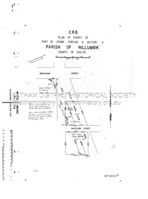
Document - Survey Plan, Country Roads Board, SP 6802, Eltham-Yarra Glen Road; Brougham St to Dalton St, 1958
... Bible Street... Road A.F. Munday Bible Street Brougham Steet Country Roads ...1958 C.R.B. Plan of Survey of Part of Crown Portion 12 Section 4 Parish of Nillumbik, County of Evelyn Eltham-Yarra Glen Road, Shire of Eltham Shows Surveyor field notes, property ownership and building type and construction.1958, eltham-yarra glen road, a.f. munday, bible street, brougham steet, country roads board, dalton street, eltham, j.p. & e.a. sanders, j.w. & e. m. graham, l.c. skipper, l.m. jarrold, main road, napoleon street, survey plan, neil webster collection, franco and co -
 Eltham District Historical Society Inc
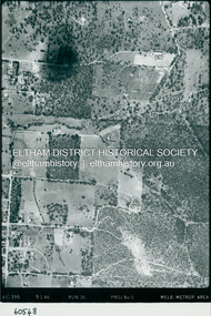
Photograph - Aerial Photograph, Landata, Eltham, Luck St; Bible St to Beard St, Dec. 1945
... Bible Street... Bible Street Eltham East Primary School frank street henry ...Centred on present day Eltham East Primary School, east of Main Rd along Luck St to Beard St Historic Aerial Imagery Source: Landata.vic.gov.au Aerial Photo Details: Project No :5 Project : MELBOURNE AND METROPOLITAN AREA PROJECT Run : 36 Frame : 60548 Date : 12/1945 Film Type : B/W Camera : EAG4 Flying Height : 10200 Scale : 6000 Film Number : 195 GDA2020 : 37°42'46"S, 145°09'18"E MGA2020 : 337371, 5824456 (55) Melways : 22 A4 (ed. 42)aerial photo, eltham, arthur street, beard street, bible street, eltham east primary school, frank street, henry street, luck street, stanley avenue, wycliffe crescent, neil webster collection -
 Eltham District Historical Society Inc
Document - Photocopy, Survey Fleld Notes of Part of Crown Portion 13, Section 4 at Eltham, Parish of Nillumbik, County of Evelyn, 7 May 1925
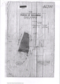
... Bible Street... Application 46785 Arthur Street Bible Street Eltham Eltham Railway ...Portion of land bounded by: Main Road, Eltham Railway Station Application 46785 J.T. Robinson, Surveyor, 7 May 1925application 46785, arthur street, bible street, eltham, eltham railway station, luck street, main road, map, survey plan -
 Eltham District Historical Society Inc
Photograph, Walter Withers Memorial Plaque, cnr Bible and Arthur Streets, Eltham designed by Joh Ebeli, c.October 1990, 1990
... Bible Street... melbourne Arthur Street Bible Street Walter Withers Walter Withers ...Roll of 35mm colour negative film, 4 stripsKodak GC400-8arthur street, bible street, walter withers, walter withers reserve, walter withers rock -
 Eltham District Historical Society Inc
Photograph, Walter Withers Memorial Plaque, cnr Bible and Arthur Streets, Eltham designed by Joh Ebeli, c.October 1990, 1990
... bible street... melbourne arthur street bible street walter withers walter withers ...Roll of 35mm colour negative film, 4 stripsKodak GC400-8arthur street, bible street, walter withers, walter withers reserve, walter withers rock -
 Eltham District Historical Society Inc
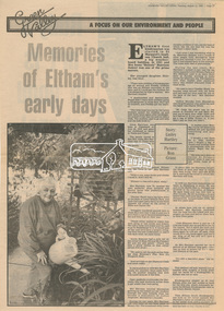
Newsclipping, Linley Hartley, Memories of Eltham's early days by Linley Hartley; picture by Ron Grant, Diamond Valley News, 13 August 1985, p37, 13 Aug 1985
... Bible Street...) Collection Bible Street Bremmer's Flat buses butcher Cheddar Black ...Memories of Mrs Irene "Rennie" HarrisonDigital file only - Digitised by EDHS from a scrapbook on loan from Beryl Bradbury (nee Stokes), daughter of Frank Stokes.1939 bushfire, alf isherwood, annie bremmer, arthur munday, beryl bradbury (nee stokes) collection, bible street, bremmer's flat, buses, butcher, cheddar black, clarrie white, collis, dalton street, eltham hotel, eltham kindergaten, eltham lower park, eltham primary school, eltham railway station, eltham south kindergarten, eltham tea rooms, farmer walsh, franklin street, freddie griffiths, greengrocer, grocers, eltham infant welfare centre, irene rennie harrison, jack carrucan, josie shannon, justus jorgensen, len harrison, main road, markets, matcham skipper, metery road, milk bar, montsalvalt, mount pleasant road, shirley harrison, st margaret's church hall, wingrove park, reminscences