Showing 444 items
matching clearing
-
 Glenelg Shire Council Cultural Collection
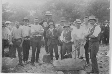
Photograph - Photograph - Group of people in a bush clearing, n.d
Black and white photo mounted on heavy card. Group of 22 men and women posing in a bush clearing, unknown location in Portland. Estimated dress late 19th, early 20th Century.Front: 'Portland Victoria' - pen Back: 'Thin Cards for Framing Purposes' - pen -
 Orbost & District Historical Society
black and white photographs, 1934
These photographs were taken just after the McKillop's Bridge was completed after the flood damage. The current McKillop’s Bridge was built by the Country Roads Board in two stages between 1931-36, during which its height was raised after the original bridge superstructure was washed away in record floods of January 1934, prior to its original official opening. In its reconstructed form the original concrete abutments were turned into additional piers and the welded-steel trusses were cantilevered back over them to meet the new higher road approaches. It is sited at McKillops Crossing, named after pioneer overlanding squatter George McKillop who crossed here in 1835. This was a stock crossing place for almost a century before the bridge was constructed. (info. from Victoria Heritage Register)This is a pictorial record of the history of McKillop's Bridge, in itself of historical significance for its association with Victoria's long and important pastoral history, its technicl significance and aesthetic significance.Three black / white photographs. 3133.1 shows the approach to a washed away bridge. 3133.2 is of a bridge over a river with men clearing debris. 3133.3 is a close-up showing the wreckage of the bridge.mckillop's-bridge snowy-river flood-damage-1934 -
 Bendigo Historical Society Inc.
Document - VICTORIA HILL - LETTER TO MR D ALLEN FROM ALBERT RICHARDSON
Handwritten carbon copy of a letter from Albert Richardson to Mr D. Allen, President of the Rotary Club of Bendigo South thanking the Club for the three weekend working bees clearing the rubbish and vegetation.document, memo, victoria hill, victoria hill, letter to mr d. allen from albert richardson, rotary club of bendigo south, central deborah, albert richardson, bendigo branch of royal historical society, bendigo & district tourist association, bendigo trust -
 Lakes Entrance Historical Society
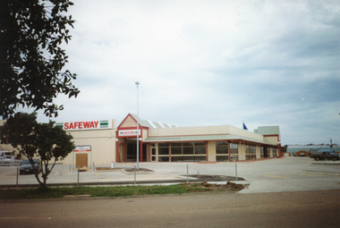
Photograph - Safeway Supermarket Lakes Entrance, Holding M, 1994
Site clearing commenced May 1994, on the site of St Brendans Catholic School. Also twelve other Photographs from site clearing, through construction stages July 1994 including 13 other photographs in LERHS Library Bay 4Colour photograph of Safeway Supermarket, Lakes Entrance, Victoriaretail trade, buildings -
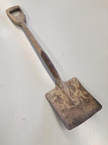 Nhill Aviation Heritage Centre
Tool - Shovel, c1940
This shovel was purchased at the clearing sale here on the Aerodrome after the war.Steel square mouth shovel with one short piece wooden handleMintern, Made by Mintern products Richmond Victoriashovel, spade, schultz, -
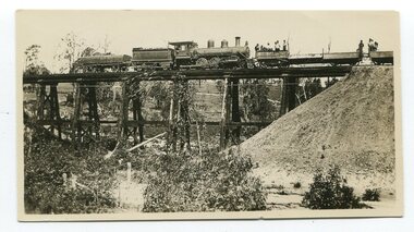 Orbost & District Historical Society
black and white photographs, 20th century
These photographs are probably of bridges on the East Gippsland railway line. 3162.2 is possibly Hospital Creek and 3162.3 possibly Burn Road Newmerella. The Orbost-Bairnsdale railway initially played a crucial role in developing agricultural industries in Gippsland as well as tourism. It opened in 1916 and operated until 1987, principally carrying timber and farming produce. In the early days of the railway's operation dedicated passenger trains ran but these ceased by the 1930s. The line was completely closed to freightage in 1987.The track infrastructure was dismantled in 1994 and has been redeveloped as the East Gippsland Rail Trail.These photographs are associated with the history of the Orbost-Bairnsdale railway line and therefore reflects the role that the rail line played in the social and economic history of Orbost. Three black / white photographs of railway bridges. 3162.1 has a steam train on the bridge. 3162.3 shows three men on the right working at clearing vegetation. 3162.3 has been taken from a height.orbost-bairnsdale-railway east-gippsland-railway bridges-railway -
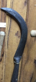 Mont De Lancey
Tool, Slasher, Unknown
A handmade slasher with a long wooden handle and a heavy sharp steel blade attached with a rivet to the handle. It was efficient for clearing thin and dense low-lying scrub or bush where an axe would be too clumsy. Indiscernable inscriptiontools, agricultural equipment, agricultural tools, slashers, gardening tools -
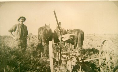 Stawell Historical Society Inc
Photograph, Mr Joseph Mitchell at Deep Lead ploughing in the scrub
Deep Lead Scenes J Mitchell ploughing in the scrub part of clearing the land.stawell deep lead -
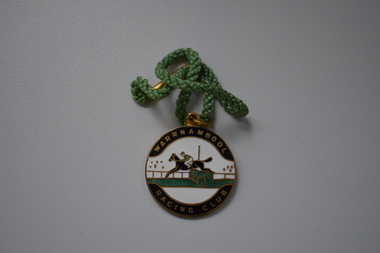 Warrnambool and District Historical Society Inc.
Badge, Stokes, Warrnambool Racing Club, 1956
This is a badge issued to members of the Warrnambool Racing Club for the 1956-7 season. Race meetings have been held in Warrnambool since the early days of European settlement, from 1848 on, with the Warrnambool Racing Club formed in 1854. The present day race track was first used in the late 1850s. The most important meeting of the Warrnambool Racing Club is the May Racing Carnival held over three days with the main feature being the well-known Warrnambool Grand Annual Steeplechase. This is a local badge and is retained as an example of a member’s badge of the Warrnambool Racing Club in the mid 1950s. This is a round metal badge with gold lettering on a black background and a black, green and gold image of a horse and rider clearing a hurdle. The badge has a metal ring at the top and a green cord with a gold metal fastener is attached. Warrnambool Racing Club Not Transferable Season 1956-1957 139 Stokes warrnambool racing club, history of warrnambool, badge -
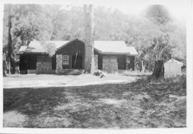 Halls Gap & Grampians Historical Society
Photograph - B/W, C 1946
A photo of the Comfort Station in the Halls Gap Picnic and Camping Reserve.The photo shows a wood and stone building at the rear of a clearing with a large eucalyptus tree growing close to the front of it. In the background is heavy bush. A tent or large cloth can be seen on the right beside a large tree stump.buildings, mountain grand -
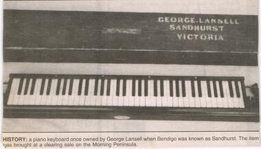 Bendigo Historical Society Inc.
Newspaper - JENNY FOLEY COLLECTION: HISTORY
Bendigo Advertiser '' The way we were'' from 2002. History: a piano keyboard once owned by George Lansell when Bendigo was known as Sandhurst. The item was bought at a clearing sale on the Morning Peninsula. The clip is in a folder.newspaper, bendigo advertiser, the way we were -
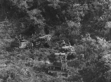 National Vietnam Veterans Museum (NVVM)
Photograph, Gibbons, Denis, Miss Fit
Denis Gibbons (1937 – 2011) Trained with the Australian Army, before travelling to Vietnam in January 1966, Denis stayed with the 1st Australian Task Force in Nui Dat working as a photographer. For almost five years Gibbons toured with nine Australian infantry battalions, posting compelling war images from within many combat zones before being flown out in late November 1970 after sustaining injuries. The images held within the National Vietnam Veterans Museum make up the Gibbons Collection A black and white photograph of An armoured Engineer D8 bulldozer 'Miss Fit' involved in land and mine clearing operations up to the foothills of the Long Hai Mountains supported by Centurian Tanks and APCs out of Firebase Thrust photograph, centurion tank, armoured personnel carrier, long hai hills, firebase thrust, gibbons collection catalogue, d8 bulldozer, long hai mountains, "miss fit", denis gibbons -
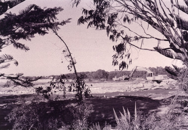 Lakes Entrance Historical Society
Photograph - Bullock Island, Fish Marie, 2005c
Black and white photograph showing heavy machinery clearing the site of Pecks fish processing factory on Bullock Island, photo also shows dumped sand on island and Kalimna Heights in background. Lakes Entrance Victoriaislands, topography, machinery -
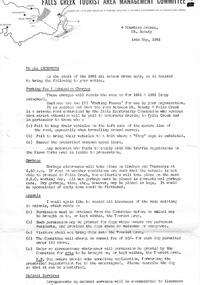 Falls Creek Historical Society
Document - To All Licensees - Parking Fee & Admission Charges; Garbage; Animals
Bob (Herman) Hymans (a former member of the Royal Netherlands Navy) was born in Bloemendaal, Holland on 30th September 1922. During World War II he fought against the Japanese in the Dutch East Indies (now Indonesia) and was imprisoned in Changi and on the Burma Railway. After gaining qualifications as a Ski Instructor, Bob arrived in Falls Creek in July 1950. Working as an Instructor and Supervisor at Bogong Lodge, Bob decided his future was in accommodation. He was successful in negotiating an indenture for land from the State Electricity Commission (SEC). It took Bob two years to build his Grand Coeur Chalet but, tragically, it was burned down in August 1961. Bob also built the first Chairlift in Australia. This was a single chairlift and the structure was built from wooden electricity poles. He was constantly full of new ideas and proposals for the village. Bob Hymans died on 7th July 2007. This Collection of documents and letters tells the story of Bob's endeavours to develop Falls Creek into the ski village it is today.This item is significant because it documents actions taken by the Falls Creek Tourist Area Management Committee in their role overseeing the Tourist Area.A circular from the Management Committee prior to the 1963 Ski season. It clarifies regulations and expectations related to parking fees and admission charges, garbage disposal, animals, water supply, run clearing and race line crossings.falls creek tourist area management committee, falls creek administration -
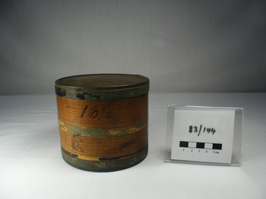 Dunkeld Museum Inc.
Box, Collar, Edward Henty's Collar Box, Late 18th century
This collar box was purchased at a clearing sale at the Henty property to wind up his estate .Beleived to be Edward Henty's collar box.Wood veneer circular collar box with tin rims on base and lid. Veneer overlapped and glued. Part of a paper label glued on the lower half of the box.16 and 1/2 on the side in ink. -
 Department of Energy, Environment and Climate Action
Heavy brush cutter
Used to clear scrub and undergrowth. Straight blade was useful when clearing road embankmentsHeavy Brush cutter Colour on handle indicates FCV district ownershipforests commission victoria (fcv), hand tools -
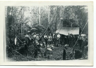 Orbost & District Historical Society
black and white photograph, 1897
This photograph shows a group of surveyors setting up at Treasury Camp - April 18 1897. Treasury camp was possibly in the Murrungowar area in East Gippsland.This is a pictorial record of a late 19th century bush camp set up by surveyors involved in determining land settlement in East Gippsland.A faded black / white photograph on a black buff card of a group of men and several pack horses standing around a campfire. The camp is in a clearing in dense forest and tents are set up with some bark coverings. There is a copy with the original.surveyors-camp-east-gippsland -
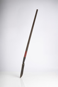
 Mont De Lancey
Tool, Slasher, Unknown
A hand slasher with a long wooden handle and a heavy sharp steel rectangular blade attached with rivets to the handle. It was efficient for clearing thin and dense low-lying scrub, ferns or bush where an axe would be too clumsy. '232205' is stamped on the flat blade but the writing is Indiscernible. tools, agricultural equipment, agricultural tools, slashers, gardening tools -
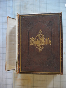 Clunes Museum
Book - HOLY BIBLE, EBERHARD BIBLE
MR SUTTON PURCHASED THIS AT A CLEARING SALE OF ITEMS FROM THE EBERHARD HOME IN FRASER STREET CLUNESBROWN LEATHER COVERED BIBLE WITH GOLD LETTERING AND TOOLING ON THE FRONT COVER, SPINE AND INSIDE COVERPRESENTED TO JUSTUS WILHELM THEODOR EBERHARD AND ELIZABETH PRICE ON THE OCCASION OF THEIR MARRIAGE SEPT 23RD 1873 INSCRIBED WITH MARRIAGE DATE AND SUBSEQUENT CHILDREN/OFFSPRINGholy bible, eberhard family -
Glenelg Shire Council Cultural Collection
Artwork, other - Posters, AUDIO-VISUAL CENTRE ED. DEPT. VIC, MIGRATION TO AUSTRALIA DURING THE 19TH CENTURY, n.d
Reproduction from 'The Graphic', October 9, 1880. 'Arrival of Emigrants at Sydney: An Address by the Emigration Agent - Clearing the Ship' (8) Set of 8 posters with immigration theme for use in Victorian schools. Classroom Picture No. 94 (1) to (8) -
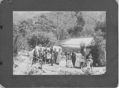 Halls Gap & Grampians Historical Society
Photograph - B/W, C 1903
The Willoughby's, Lawsons & Goodsons, camping at the base of Mackey's Peak near the child's grave. The back of the mount records that there are four Goodsons, G'dma Sarah Campbell, Aunty Thomson's Grandmother, Glad Jones (Cashin), Jim W(illoughby) nursing Mavis McAllen, Allan's Mother (not clear if Mavis McAllen is "Allan's Mother" or if Allan's Mother is another person in the photo), Clarice Willoughby, Allen W(illoughby), four Lawsons.The photo shows a large group of people (men, women and children) standing in front of a group of three tents in a clearing. The area is surrounded by bush. In the left foreground there is a cauldron hanging from a stand mad;'e of branches over a fireplace."Willoughby's camp at Halls Gap near child's grave 1903. 4 Goodsons, G'dma Sarah Campbell, Aunty Thomson's Grandmother, Glad Jones (Cashin), Jim W. nursing Mavis McAllen, Allan's Mother, Clarice Willoughby, Allen W., 4 Lawsons" hand written in blue ink on back of mount.recreation, camping -
 Federation University Historical Collection
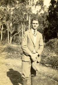
Photograph - Black and White, Vernon Holt, 1920s?
Vernon Holt was a boyhood friend of Frank Wright. Frank Wright was a renown resident of Smeaton, where he was born on 2 August 1901. He lived at Laura Villa, and attended Smeaton State School. His father William was a gold miner and his mother's name was Sarah. Their family won many singing and instrumental awards. Frank was tutored by Percy Code and was awarded a gold medal for the highest marks in the ALCM examinations in the British Colonies at the age of seventeen years. He became the Australian Open Cornet Champion by the age of eighteen. A year later, Frank conducted the City of Ballarat Band, and later the Ballarat Soldiers’ Memorial Band. He formed the Frank Wright Frisco Band and Frank Wright and his Coliseum Orchestra. These bands won many South Street awards, and Frank as conductor won many awards in the Australian Band Championship contest. In 1933 Frank Wright sailed to England to conduct the famous St Hilda’s Band and was later appointed Musical Director of the London County Council, where he organized many amazing concerts in parks, in and around the London district. He was made Professor of Brass and Military Band Scoring and conducted at the Guildhall of Music and Drama. Frank was often invited to adjudicate Brass Band Championships around Europe, in Australia, including South Street and in New Zealand. The Frank Wright Medal at the Royal South Street competition is awarded to an individual recognized as making an outstanding contribution to brass music in Australia.Black and white photograph of a young man dressed in a light coloured suit with long socks pulled over his trouser legs to the knee. He is carrying a cap and is standing in a clearing with trees and bush behind. The man is Vernon Holt.vernon holt, frank wright -
Whitehorse Historical Society Inc.
Pamphlet - Advertising brochure, Kenmare Heights Estate, 1927
Clearing sale by public auction , Saturday 26/11/1927 of Kenmare Heights Estate Mont Albert, Situated between Belmore Road, Boundary Road, Strabane Avenue, Union Road and Dunloe Avenue. Advertising material and mapknight & harwood auctioneer, auctions, kenmare height estate, union road mont albert, belmore road, relowe crescent, whitehorse road, evalina street, francesca street, mozelle street, dunloe avenue -
 Surrey Hills Historical Society Collection
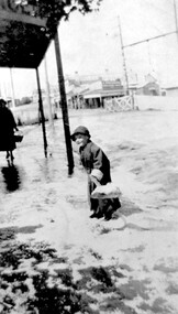
Photograph, Arthur Lyons in Union Road after a hail storm, 1924, 1924
The hail storm occurred on 2 December 1924. This is one in a series from the Lyons' photo collection. This was gifted to the SHNCHC by Arthur Frederick Lyons, son of Frederick Alphonsus (Fred) Lyons and Elizabeth Ruby Hall, who married in 1918. Fred Lyons died 4/10/1980. The Lyons’ home in Sunbury Crecent was called ‘Knopshambury’ - this was probably a misspelling of Knockshanbally in Co Kilkenny, the birth place of Fred’s father, Thomas Edmund Josias Lyons (1846-1915). Arthur was born in Surrey Hills on 12 Jun 1920. He became a motor mechanic / welder and lived at 55 Sunbury Crescent. The donation was made while he was in hospital. He died shortly afterwards (23 Sep 1990). Donation was finalised by a neighbour, Mrs Florence Ann Armitstead, wife of Glen Victor Armitstead. Glen was a local hairdresser. They moved to 11 Sunbury Crescent after their marriage in 1939. Arthur had no relatives to distribute the material to.Historically significant as it shows clearly the buildings and railway crossing in Union Road.Black and white photo of Arthur Lyons as a child with a shovel in hand taken at the cab rank near the Surrey Hills station, clearing up after a hail storm in 1924. The railway gates and overhead lines can be seen in the background. On back in pencil was "Copied 1996" and also "2/12/1924"railway crossings, hail storms, arthur lyons -
 Halls Gap & Grampians Historical Society
Photograph - B/W, C early 1900s
The photo shows a woodchopping competition in an unknown location in the Grampians. The identity of the people in the photo is unknown.The photo shows a large group of men standing in a clearing, around a cut log. One man has his foot on the log and is holding an axe and a crow bar which are lodged in the log. There is a man holding a book standing on a rock in the centre.recreation, woodchopping competition -
 Orbost & District Historical Society
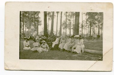
black / white postcard, late 19th - early 20th century
This postcard seems to have been written by Grace Cameron to Annie (Cameron) Gilbert. There is mention of a harvest festival.The Cameron and Gilbert families are early settlers of the Orbost area. This photograph is a pictorial record of dress in the late 19th and early 20th century. It depicts the the high standards of dress at informal occasionsA photograph / postcard which shows a group of men and women in a large forest clearing. The women are dressed in white(?) dresses with ribbon bows at the neck. The men are in suits. Most are wearing hats. In the back right corner are two horse - drawn carriages.on the back is a hand -written lettercameron-annie celebrations-outdoor -
 National Vietnam Veterans Museum (NVVM)
Photograph
Three coloured Photograph in black frame with white matting 1. PTE John Bryant inspecting push bike 2. CPL Mancer in a BE2-Bomb Crater 3. FSB Coral clearing enemy bunker 25th May 1968photograph, pte john bryant, cpl mancer, b52-bomb crater, clearing bunker, battle of coral-balmoral -
 Greensborough Historical Society
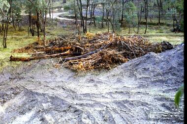
Slide - Photograph, John Ramsdale, Headwaters of the Plenty River: Slide 85, 1990s
Photograph shows fallen trees with road in background. This the headwaters of the Plenty River and clearing of timber can cause problems such as erosion.Part of the John Ramsdale collection of slides and audio visual material.Colour photograph scanned from slide.No maker's marks. No caption on slide.plenty river -
 National Wool Museum
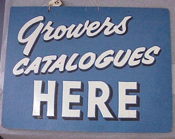
Sign
One of group of items donated by Elders Pastoral, mostly left over from various clearing sales at their previous offices.GROWERS CATALOGUES HEREelders vp, sign, catalogue sign, hay, mr jim e. - elders vp -
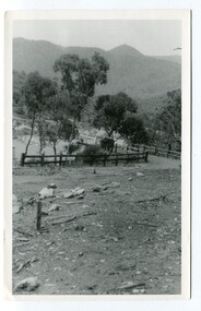
 Kiewa Valley Historical Society
Photograph – Set of 3 black and white photographs of Bogong Village circa late 1930's - 1940's during early construction of Lake Guy ( in the foreground), Late 1930's - 1940's
In 1940 Field Headquarters for the Kiewa Scheme were established at Bogong with office, workshop facilities and accommodation for workmen, staff and some families constructed. (There had been a 'tent camp' on this site in 1939 but was destroyed by bush fires) Construction of accommodation continued until 1947. A total of 40 houses plus a hostel for single staff, post office, police station, medical centre and primary school all with water and sewerage and electricity supply. The staff hostel was known as Kiewa House and is now occupied by the Education Department. Lake Guy was named after Mr. L.T. Guy who was the Resident Engineer in charge of construction work and associated activities on the Kiewa area. He held this position from 1939 to November 1946 when he was transferred to Head Office. The Bogong Township was developed firstly as an accommodation centre (base camp) for construction workers employed under the Kiewa Hydroelectric Scheme. Due to the influx of European workers into the Township the beautification of the immediate surrounds (gardens etc.) had a distinct European flavour. This environment has been very beneficial for tourism in later years. At the completion of the scheme, in the 1960's, the village was opened to public/tourism use. Strict environmental control has not allowed for any extensive redevelopment in tourist accommodation and basically restricted it to the accommodation initially built for the construction workers. Activities such a bike riding, snow skiing, restricted horse riding and bush walking on the Alpine plains and mountains are now a viable part of the Kiewa Valley Tourist Industry. The lake is one of the many water storage reservoirs used to supply the power stations their main power to run the huge turbines generating the final product, electricity3 black and white photographs of the Bogong camp area showing the clearing of trees for the construction of the Junction Dam and Lake Guy. Some administration buildings have been constructed, but part of the tent camp can be seen to the right of the photograph in front of the buildings. bogong village; junction dam; lake guy; kiewa hydro electric scheme; secv