Showing 1222 items matching "crown land"
-
 Phillip Island and District Historical Society Inc.
Photograph Album, Kodak, Phillip Island Cemetery, c 1990
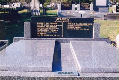
... aside as Crown Land in the land settlement of 1868... native trees. In all 25 acres of land were set aside as Crown ...The Album was compiled by Nancy McHaffie late 1990's, with the assistance of Edith Jeffery's, with her book "Garden of Memories" and extensive knowledge of Phillip Island. The Cemetery lies back from the road and is surrounded by Manna Gums, rare Peppermint Gums, Blackwoods and other native trees. In all 25 acres of land were set aside as Crown Land in the land settlement of 1868. There are 6.2 acres of wetlands near the cemetery entrance.466-56: Alexander McLardy Sr. The descendants of Alex McLardy came to Phillip Island in the year 1886. A builder by trade, he built a great number of houses and buildings on the Island. He was also the founder of the Guesthouse "Glencoe". At 90 years of age he could still read well without the aid of glasses. He died in 1956 aged 95. Others buried in the double graves are: Robert Alexander died 1926 aged 10 months, Alexander Thomas died 1971 aged 76, Beatrice died 1966 aged 73, Donald Alexander died 1992 aged 64 and Claire Isobel died 1993 aged 61. 466-57: Walter Findlay. Walter's parents George and Mary, came to Australia in 1852. Walter was born in Sale circa 1883. He married Henrieta Kennon and they lived and farmed in Settlement Road, Cowes prior to their shop and residence being built in Warley Avenue, Cowes. The shop carried general merchandise and confectionery. The property was absorbed by Bass Coast Family Medicine on the west side of Warley Avenue. Henrieta died September 1965 aged 84. Walter died July 1965 aged 82.phillip island cemetery, alexander mclardy, walter findlay, nancy mchaffie, edith jeffery -
 Phillip Island and District Historical Society Inc.
Photograph Album, Kodak, Phillip Island Cemetery, c 1990
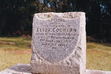
... aside as Crown Land in the land settlement of 1868... aside as Crown Land in the land settlement of 1868 ...The Album was compiled by Nancy McHaffie late 1990's, with the assistance of Edith Jeffery's, with her book "Garden of Memories" and extensive knowledge of Phillip Island. The Cemetery lies back from the road and is surrounded by Manna Gums, rare Peppermint Gums, Blackwoods and other native trees. In all 25 acres of land were set aside as Crown Land in the land settlement of 1868. There are 6.2 acres of wetlands near the cemetery entrance.a) Grave stone of Eliza Coghlan b) Grave stone of Eliza Coghlan with Edith Jeffery standing beside. Eliza was born in West Heath, Ireland. She arrived in Australia on the immigrant ship "Thomas Arbuthnot". She came to Phillip Island as house-keeper to James Duffus and served for 40 years. She was often seen walking to Cowes, about five miles, carrying a heavy turkey. The main road to the cemetery was named in her honour. It has been claimed that Eliza with the oldest subject of Queen Victoria. She died in February 1910, at the age of 113.phillip island cemetery, nancy mchaffie, edith jeffery -
 Bendigo Historical Society Inc.
Document - MCCOLL, RANKIN AND STANISTREET COLLECTION COLLECTION: CENTRAL NAPOLEON GOLD MINING CO. N.L, 30th October 1939
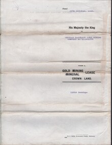
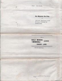
... Document: Gold Mining Lease crown Land No 11016 Bendigo... crown Land No 11016 Bendigo, Entered in the register book Vol ...Document: Gold Mining Lease crown Land No 11016 Bendigo, Entered in the register book Vol. 324 fol. 35754, Embossed seals of Central Napoleon Gold Mining Co N.L. and Kin g George VI, Map: Mining District of Bendigo, County of Bendigo, Parish of Sandhurst, located at Harvey & Inglis Streets, During the reign of King George VI (document orignally had Edward VIII).organization, business, industry - mining, mccoll rankin & stanistreet, mining, gold mining, central napoleon -
 Bendigo Historical Society Inc.
Document - MCCOLL, RANKIN AND STANISTREET COLLECTION: INDENTURE NORTH DEBORAH MINING COMPANY, 20th November, 1952
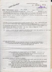
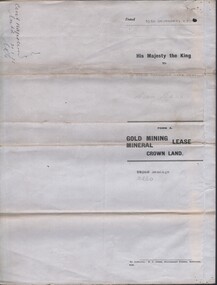
... 6 page document ' Gold Mining Lease Crown land Number 11307... ' Gold Mining Lease Crown land Number 11307 Bendigo' plus map ...6 page document ' Gold Mining Lease Crown land Number 11307 Bendigo' plus map. Indenture document between Queen Elizabeth 11 and North Deborah Mining Company No Liability, Parish of Sandhurst, dated 20th November, 1952 re Vol 333, Folio 053. Land indicated by yellow on map and below ' a depth of one hundred and fifty feet from the surface of the land indicated by purple colour and delineated on the plan' Document signed by J. Stanistreet, Manager, North Deborah Mining Company No Liability. Map, fixed to document, heading ' Mining District of Bendigo, No. 11307, County of Bendigo, Parish of Sandhurst, Total area 13 acres 2 roods, 11 perches. Map shows large dam on Crown land, transmission line excised 150 ft., written on purple area. Underneath map ' provided that the dam indicated on the said plan is hereby reserved'.bendigo, mining, north deborah mining company -
 Warrnambool and District Historical Society Inc.
Map - Maps, Soldiers Settlement WW2, Circa 1950
... and also give opportunities to returned soldiers. Crown land... give opportunities to returned soldiers. Crown land and other ...The soldiers' settlement scheme operated after the first and second world wars in an effort to more closely settle the land and also give opportunities to returned soldiers. Crown land and other larger estates were acquired for the purpose. Most of these maps relate to the area north of Warrnambool where many of the subdivisions were parts of larger estates.These maps pertaining to the Soldiers' Settlement program, relate to an interesting part of Australian and local history. As such they have historic and social interest and significance.A collection of 25 paper maps which relate to to the soldiers settlement post World War 2. Some have details of the people allocated the land and some smaller maps have the printed details of the applicants requirements.Text is black on white paper which in some cases is quite aged. The maps are as follows: .1 Narrapumelap Estate ( Ripon & Hampden) .2 Narrapumelap Estate Part 2 (Villers & Ripon) .3 Narrapumelap Estate Part 3 ( Villiers & Ripon) .4 Burrumbeet Estate ( Ripon) .5 ' Berrambool' Estate 9 Hampden & Villiers) .6 ' Hopkins Hill' Estate Villiers 4011 acres .7 Caramut North No 2 Estate ( Villiers ) .8 ' Morpor' Estate ( Villiers) 4172 acres .9 ' Morgiana' Estate ( Normandy) 3453 acres .10 ' Chatsworth House' ( Villiers) 9341 Acres .11 ' East Elwood' Estate Villiers 2407 acres .12 Grey's Estate ( Mornington) 1151acres .13 ' Rowes Estate' ( Buln Buln Gippsland 733 acres .14 'Tarrone' Estate No 2 Part map .15 'Chaldon Meade' Estate (Bourke) Bulla 517 acres .16 ' Terranallum South' Estate Hampden 3757 acres .17 ' Brung Brungle' Estate Dundas 695 .18 ' Armidale ' Estate ( Dundas)2108 acres .19 ' Moyne Falls' Estate ( Villiers) 627 acres .20' Yulong' Estate 9 Lowan 6321 acres .21 Murray Valley Irrigation District 9 Moira)113 acres .22 Murray Valley Irrigation District 103 acres .23 ' Mount Fyans' Estate ( Hampden) .24 ' Barwidgee ' Estate ( Villiers) 4277 acres .25 'Pine Hills' Estate 2nd portion ( Lowan) 6190 acres narrapumelap, berrambool, hopkins hill, caramut north, morpor, chatsworth house, east elwood, terrinallum, moyne falls, tarrone, caramut soldiers settlers, burrumbeet, morgiana, grey's estate mornington, chaldon meade, brung brungle -
 Sunbury Family History and Heritage Society Inc.
Photograph, Sunbury Football team, C 1930s - 1940s
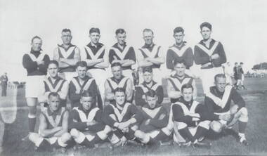
... was known as Sunbury's sports ground until 1949, when crown land... was known as Sunbury's sports ground until 1949, when crown land ...Th members of the Sunbury Football team were photographed in the former sports ground that was on railway land bounded by Evans and Macedon Streets and the railway land. For many years that site was known as Sunbury's sports ground until 1949, when crown land facing Riddell Road was developed as a recreation and sport's ground and became known as Clarke Oval.Sport has played a prominent role in Sunbury and district's social life since the mid nineteenth century.A non-digital of a copied and enlarged black and white photograph of a team of football players standing and sitting in three rows in a sports ground. sunbury football club, "the swifts', sports clubs, football, australian rules football -
 Sunbury Family History and Heritage Society Inc.
Photograph, Bulla Presbyterian Church
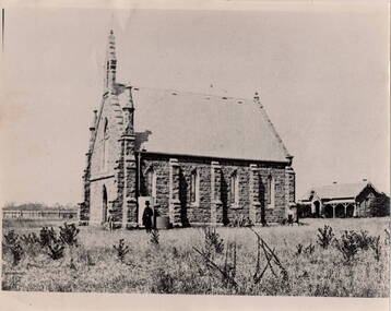
... St.Andrew's Presbyterian Church at Bulla was built on Crown...St.Andrew's Presbyterian Church at Bulla was built on Crown ...St.Andrew's Presbyterian Church at Bulla was built on Crown land that the congregation received on 6th September 1858. It overlooks Oaklands Road and the surrounding farms as well as the Tullamarine Airport. The building at the rear is the former manse. It functioned as a place of worship for over 150 years and celebrated its 150th anniversary in 2009. The entire property is now privately owned.It was one of the first permanent church buildings to be built in the district.A non-digital black and white photograph, with a cream border, of a blue-stone church with a high-pitched slate roof and a tall belfry its the main entrance. A smaller residence is visible in the background. The buildings have been erected in an open grassed area.presbyterian church, bulla, oaklands, churches -
 Bendigo Historical Society Inc.
Document - MCCOLL, RANKIN AND STANISTREET COLLECTION: CENTRAL NAPOLEON GOLD MINING CO. N.L, 15th August 1950
... Document: Gold Mining Lease Crown Land No 11272 Bendigo... Crown Land No 11272 Bendigo, entered in the register book Vol ...Document: Gold Mining Lease Crown Land No 11272 Bendigo, entered in the register book Vol 331 Fol 36450, embossed seals of Central Napoleon Gold Mining Co N.L & King George VI, Map: No 11272 Mining District of Bendigo, Parish of Sandhurst, County of Bendigo, shows the minerunning between Harvey & Inglis Streets and crossing Empire and Sparrowhawk Roads and running a good distance beyond Sparrowhawk Rd.organization, business, industrial - mining, mccoll rankin & stanistreet, mining, gold mining, central napoleon -
 Bendigo Historical Society Inc.
Document - MCCOLL, RANKIN AND STANISTREET COLLECTION: CENTRAL NAPOLEON GOLD MINING CO. N.L, 3rd November 1943
... application for a grazing licence over a block of crown land within... application for a grazing licence over a block of crown land within ...Document: Letter sent to Central Napoleon Gold Mining Co from McColl Rankin and Stanistreet regarding Mr Daniel Keane's application for a grazing licence over a block of crown land within the boundaries of the Company's Lease No 10260, this letter is enquiring whether or not the company has any objections to granting Mr Keane's application, the area concerned is marked in grey lead pencil on the map attached to the lease numbered 2205.704a.organization, business, industry - mining, mccoll rankin & stanistreet, mining, gold mining, grazing application, central napoleon, daniel keane -
 Bendigo Historical Society Inc.
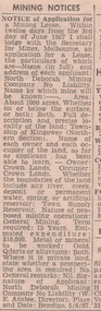
Newspaper - MINING REPORTS - NOTICE OF APPLICATION FOR A MINING LEASE
... in the Township of Kingower (Nrthern Section). Owner/occupier - Crown.../occupier - Crown Land, so far as the applicant has been able ...Notice of Application for a Mining Lease from the Bendigo Advertiser 8/6/1967. Proposed lease is for about 1000 acres in the Township of Kingower (Nrthern Section). Owner/occupier - Crown Land, so far as the applicant has been able to learn. Term required 15 years. Applicant was North Deborah Mining Company No Liability (W. E. Anstee, Director). Place and date: Bendigo, 5/6/67.newspaper, bendigo advertiser, mining reports, notice of application for a mining lease, north deborah mining company no liability, w e anstee -
 Melton City Libraries
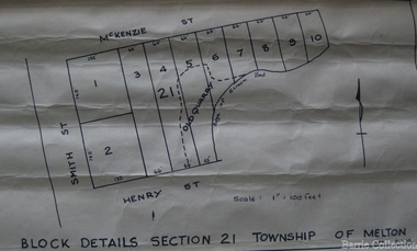
Map, Block details section 21 Township of Melton, 1965
... In 1861, Mary Dowling and John Luby obtained Crown Grant... In 1861, Mary Dowling and John Luby obtained Crown Grant land ...In 1861, Mary Dowling and John Luby obtained Crown Grant land on the corner of Smith and McKenzie Street Melton.Section 21 is covers the block of Smith, Henry and McKenzie Street Meltoncouncil -
 Whitehorse Historical Society Inc.
Document, Part of the history of the Lowen's, n.d
... Lowen Family bought land on Crown Allotment 100 in 1867.... on Crown Allotment 100 in 1867. Lowen Family bought land on Crown ...Lowen Family bought land on Crown Allotment 100 in 1867.Lowen Family bought land on Crown Allotment 100 in 1867.Lowen Family bought land on Crown Allotment 100 in 1867.lowen family, pioneers -
 Bendigo Historical Society Inc.
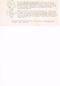
Document - EXTRACT FROM UNKNOWN SOURCE: CHARLES SHERRETT, MOUNT ALEXANDER
... of stock on Crown Land at Port Phillip, licences and the mention... to the Colonial Secretary (1840) re depasturing of stock on Crown Land ...Extract from unknown source re Charles Sherrett, Mount Alexander. This typewritten two paragraphs related to a letter from Captain Lonsdale to the Colonial Secretary (1840) re depasturing of stock on Crown Land at Port Phillip, licences and the mention of Charles Sherrett ''travelling to Mount Alexander'' as place of residence. In a handwritten (crossed out??) note to the side of this typewritten extract is the following: ''Letter of the Town Clerk Bgo 1929 re correct date to celebrate centenary''.document, memo, report, captain lonsdale. licences. charles sherrett.. -
 Kew Historical Society Inc
Photograph - Yarra River, Kew, 1925
... at Kew. From the 1840s, at the Crown Land Sales, lots adjacent... of a stretch of the Yarra River at Kew. From the 1840s, at the Crown ...Henry Beater Christian (1886-1962) , was a descendant of one of the earliest settler families in Kew. Employed at the Kew Asylum as a 'public servant', he was a skilled amateur photographer, photographing numerous scenes in Kew and on his travels around Victoria. The majority of his photographs date from 1916 to 1929. His finest photographs are housed in two photograph albums. Digital copy of a photograph from page 3 of the 47-page photograph album containing 261 gelatinous silver images, loaned by Diane Washfold with permission given to digitise and hold a copy in our collection. A photograph of a stretch of the Yarra River at Kew. From the 1840s, at the Crown Land Sales, lots adjacent to the river were sold and developed as dairy farms, hence the presence of cattle until the land was subdivided or created into golf courses during the twentieth century. "Yarra Rvr / Kew / 1925"henry beater christian (1886-1962), landscape photography, kew (vic.) — yarra river, christian-washfold collection, photograph albums, dairying -- kew (vic.) -
 Hume City Civic Collection
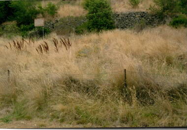
Photograph, The Terraces, 1980s
... Legislative Assembly. He acquired a parcel of crown land and proceeded... Legislative Assembly. He acquired a parcel of crown land and proceeded ...The stone wall is part of the terraces that were built into the hillside at the winery at Goonawarra. They were constructed in the early days when the vineyard was established to terrace the hillside for growing vines. The winery was originally established by Joh Goodall Francis, a former member of the Victorian Legislative Assembly. He acquired a parcel of crown land and proceeded to develop it as a vineyard. The terraces were built by vignerons, who were employed to work on the property. Goonawarra Winery was one of a number of vineyards that were established in the Sunbury area in the 1800s. The volcanic soil and temperate climate were ideal for grape growing.A coloured photograph of a stone wall with a notice to the left of the wall and long dried grassland in the front. A barbed wire fence is in the foreground.terraces, vineyards, goonawarra, james goodall francis -
Bendigo Historical Society Inc.
Map - CAMPBELL COLLECTION: BENDIGO AND DISTRICT MAPS
... forest and crown land, highway main road access forest tracks..., reserved forest and crown land, highway main road access forest ...Map. Bendigo Whipstick Forest Park, 1:75,000, reserved forest and crown land, highway main road access forest tracks. New Moon Mine, Elliot Dam, Nuggety Dam, Rogers Tree, Old Tom Mine, Blow Holes, Skylark Dam, Monument Rock, Hartland Eucalyptus Still and Dam, Hartland Eucalyptus Farm, Millwood Dam, Sandner Eucalyptus Still Site, Various unmarked dams. (number 391 in map cupboard 1)map, bendigo, country lands -
 Bendigo Historical Society Inc.
Document - LANDS OFFICE - CROWN LANDS SURVEYED AND SOLD SANDHURST, 1860 onwards
... . Contains details of crown land surveyed and sold in the district... with buff spine and corners. Contains details of crown land surveyed ...Journal: LANDS OFFICE - CROWN LANDS SURVEYED AND SOLD SANDHURST green hard cover journal with buff spine and corners. Contains details of crown land surveyed and sold in the district of Sandhurst. Indexed in front by parish, alphabetical double pages not numbered. On LH page, parish, town, suburban, country, date of survey. On RH page, date of sale, auction, selection, price, total amount, purchaser. On spine ' index book' 'F' and '09'. Dated from 1860 onwardsLands Officeland sales, bendigo -
 Bendigo Historical Society Inc.
Photograph - DWYER COLLECTION: STONE WELL, MAIDEN GULLY
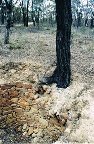
... , not Crown Land. No heritage listing for well.... revealed well still intact, and on private property, not Crown Land ...Photograph: image of stone well, Biffins Track, Maiden Gully. Circular structure lined with sandstone type stones. Measures 3.7 mt. across at widest point and is approx. 2.7 mt. deep. Large Ironbark on RH side of well. File contains letter from Mrs. Michele Dwyer, 27 Katherine Cres., Maiden Gully, dated 19th. Feb. 2003. Inspection by Kay MacGregor and Phil Wilkin in 2012 revealed well still intact, and on private property, not Crown Land. No heritage listing for well.bendigo, buildings, stone well, maiden gully, stone well, stonework, stone cutter. -
 Warrnambool and District Historical Society Inc.
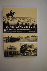
Book, StarPrinting Service Pty ltd, Soldiering On – Caramut and the Soldier Settler Movement, 2018
... soldiers. Some of the land allocated was Crown Land and some... soldiers. Some of the land allocated was Crown Land and some ...This book records the history of the post World War Two soldier settlement farms in the Caramut area. Number two in a series of books on Soldier Settlements in Western Victoria.This is a soft cover book of 315 pages. It has a buff-coloured cover with black and white photographs and white printing on the front cover and black printing on the spine. The book includes printed material, black and white photographs, maps and plans. non-fiction This book records the history of the post World War Two soldier settlement farms in the Caramut area. Number two in a series of books on Soldier Settlements in Western Victoria.james affleck, peterborough, soldier settlement, caramut, history of warrnambool, soldier settlement, caramut -
 Eltham District Historical Society Inc
Slide - Photograph, Birch Cottage, Yarra Glen Road, Christmas Hills, c.Mar. 1989
... on Crown land. In 2007 the Andrew Ross Museum began a campaign... on Crown land. In 2007 the Andrew Ross Museum began a campaign ...Historical property that sits beside Watsons Creek. In 1903 a Miners Right of one acre in area was granted to Edwin Samuel Birch. In 1907 Birch applied to purchase this land but was unable to because it was part of the creek reserve. The house existed at that time. Birch died in 1932 and his daughter Honor Mary Birch was granted a permit to occupy the residence. The future of the cottage remains precarious because of its location on Crown land. In 2007 the Andrew Ross Museum began a campaign to ensure its preservation - NL18235mm colour positive transparency (1 of 28) Mount - Kodak KodachromeProcess Date MAR 89Mbirch cottage, christmas hills, smiths gully, watson's creek, yarra glen road -
 Hume City Civic Collection
Photograph, Woodlands Homestead, c1858 - 59
... Phillip area in December 1842.. He acquired the Crown land... Phillip area in December 1842.. He acquired the Crown land ...The photograph is of the Woodland Homestead at Bulla which was sited along the Moonee Ponds Creek. William Pomroy Greene and his wife Anne, emigrated from Scotland and arrived in the Port Phillip area in December 1842.. He acquired the Crown land at Gellibrand Hill in 1843 and built the prefabricated homestead which became known as Woodlands. The people in the photograph, taken about 1859 - 60, are L- R: Possibly Sir Willian Stawell, ?, little Anne Catherine Greene at 2 years, Rawdon Greene, Mrs. Greene and Smith ( a butler).The Greene family were one of the early European settlers to acquire land in the Bulla Bulla district. The Woodlands property is now a national park and the significant Gellibrand Hill is within the park.A black and white photograph of 3 men, a lady and a child standing in a garden in front of a homestead. A wooden post and rail fence is in the foregroundwoodlands homestead, greene family -
 Eltham District Historical Society Inc
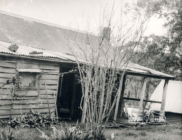
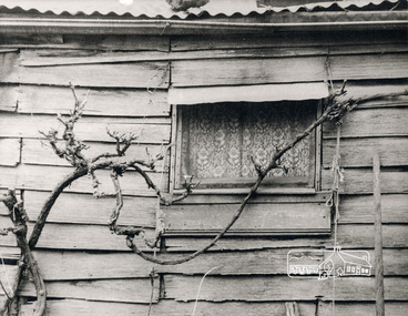
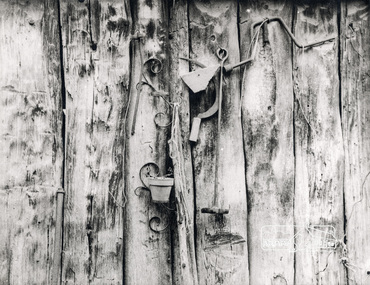
Photograph, George W. Bell, Birch Cottage, Yarra Glen Road, Smiths Gully, Aug 1969, Aug 1969
... of a permissive occupancy of Crown land comprising the creek reserve... of a permissive occupancy of Crown land comprising the creek reserve ...EDHS Newsletter No. 182, September 2008 In the late 1970s when our Society was the Shire of Eltham Historical Society, an offer was made to the Society regarding use of an old cottage at Christmas Hills. For various reasons the offer ultimately lapsed The cottage sat beside Watsons Creek just outside the then Shire of Eltham but following municipal restructuring it now lies within the Shire of Nillumbik. At that time some research on the cottage was carried out for the Society by Keith Chappel as part of a larger research project that he was doing. Keith's notes were taken from Lands Department records and showed that house is the subject of a permissive occupancy of Crown land comprising the creek reserve. In 1903 a Miners Right of one acre in area was granted to Edwin Samuel Birch. In 1907 Birch applied to purchase this land but was unable to because it was part of the creek reserve. The documents show that the house existed at that time. Birch died in 1932 and his daughter Honor Mary Birch was granted a permit to occupy the residence. The future of the cottage remains precarious because of its location on Crown land. In 2007 the Andrew Ross Museum began a campaign to ensure that it is preserved. It included a video presentation on the history of the cottage under the title of "This Old House- Birch Cottage". Black and white photographWilliams Cottage Panton Hill 1969 Not to be reproduced without permission G.W. Bell Photographer Elthamhouses, cottage, early settlers, yarra glen road, smiths gully, williams cottage, watsons creek, christmas hills, birch cottage, edwin samuel birch, honor mary birch -
 Eltham District Historical Society Inc
Photograph, George W. Bell, Detail, Kitchen, Birch Cottage, Yarra Glen Road, Smiths Gully, Aug 1969, Aug 1969
... of a permissive occupancy of Crown land comprising the creek reserve... of a permissive occupancy of Crown land comprising the creek reserve ...EDHS Newsletter No. 182, September 2008 In the late 1970s when our Society was the Shire of Eltham Historical Society, an offer was made to the Society regarding use of an old cottage at Christmas Hills. For various reasons the offer ultimately lapsed The cottage sat beside Watsons Creek just outside the then Shire of Eltham but following municipal restructuring it now lies within the Shire of Nillumbik. At that time some research on the cottage was carried out for the Society by Keith Chappel as part of a larger research project that he was doing. Keith's notes were taken from Lands Department records and showed that house is the subject of a permissive occupancy of Crown land comprising the creek reserve. In 1903 a Miners Right of one acre in area was granted to Edwin Samuel Birch. In 1907 Birch applied to purchase this land but was unable to because it was part of the creek reserve. The documents show that the house existed at that time. Birch died in 1932 and his daughter Honor Mary Birch was granted a permit to occupy the residence. The future of the cottage remains precarious because of its location on Crown land. In 2007 the Andrew Ross Museum began a campaign to ensure that it is preserved. It included a video presentation on the history of the cottage under the title of "This Old House- Birch Cottage". Black and white photographWilliams Cottage Panton Hill 1969 Not to be reproduced without permission G.W. Bell Photographer Elthamhouses, cottage, early settlers, yarra glen road, smiths gully, williams cottage, watsons creek, christmas hills, birch cottage, edwin samuel birch, honor mary birch -
 Eltham District Historical Society Inc
Photograph, George W. Bell, Detail, Cottage Entrance, Birch Cottage, Yarra Glen Road, Smiths Gully, Aug 1969, Aug 1969
... of a permissive occupancy of Crown land comprising the creek reserve... of a permissive occupancy of Crown land comprising the creek reserve ...EDHS Newsletter No. 182, September 2008 In the late 1970s when our Society was the Shire of Eltham Historical Society, an offer was made to the Society regarding use of an old cottage at Christmas Hills. For various reasons the offer ultimately lapsed The cottage sat beside Watsons Creek just outside the then Shire of Eltham but following municipal restructuring it now lies within the Shire of Nillumbik. At that time some research on the cottage was carried out for the Society by Keith Chappel as part of a larger research project that he was doing. Keith's notes were taken from Lands Department records and showed that house is the subject of a permissive occupancy of Crown land comprising the creek reserve. In 1903 a Miners Right of one acre in area was granted to Edwin Samuel Birch. In 1907 Birch applied to purchase this land but was unable to because it was part of the creek reserve. The documents show that the house existed at that time. Birch died in 1932 and his daughter Honor Mary Birch was granted a permit to occupy the residence. The future of the cottage remains precarious because of its location on Crown land. In 2007 the Andrew Ross Museum began a campaign to ensure that it is preserved. It included a video presentation on the history of the cottage under the title of "This Old House- Birch Cottage". Black and white photographDetail Cottage Entrance Williams Cottage Yarra Glen Rd Panton Hill Aug 1969 Photo - G.W.Bhouses, cottage, early settlers, yarra glen road, smiths gully, williams cottage, watsons creek, christmas hills, birch cottage, edwin samuel birch, honor mary birch -
 Eltham District Historical Society Inc
Photograph, George W. Bell, Detail, Front Wall, Birch Cottage, Yarra Glen Road, Smiths Gully, Aug 1969, Aug 1969
... of a permissive occupancy of Crown land comprising the creek reserve... of a permissive occupancy of Crown land comprising the creek reserve ...EDHS Newsletter No. 182, September 2008 In the late 1970s when our Society was the Shire of Eltham Historical Society, an offer was made to the Society regarding use of an old cottage at Christmas Hills. For various reasons the offer ultimately lapsed The cottage sat beside Watsons Creek just outside the then Shire of Eltham but following municipal restructuring it now lies within the Shire of Nillumbik. At that time some research on the cottage was carried out for the Society by Keith Chappel as part of a larger research project that he was doing. Keith's notes were taken from Lands Department records and showed that house is the subject of a permissive occupancy of Crown land comprising the creek reserve. In 1903 a Miners Right of one acre in area was granted to Edwin Samuel Birch. In 1907 Birch applied to purchase this land but was unable to because it was part of the creek reserve. The documents show that the house existed at that time. Birch died in 1932 and his daughter Honor Mary Birch was granted a permit to occupy the residence. The future of the cottage remains precarious because of its location on Crown land. In 2007 the Andrew Ross Museum began a campaign to ensure that it is preserved. It included a video presentation on the history of the cottage under the title of "This Old House- Birch Cottage". Black and white photographDetail of Front Wall Williams Cottage Yarra Glen Rd Panton Hill Aug 1969 Photo - G.W.Bhouses, cottage, early settlers, yarra glen road, smiths gully, williams cottage, watsons creek, christmas hills, birch cottage, edwin samuel birch, honor mary birch -
 Eltham District Historical Society Inc
Photograph, George W. Bell, Detail, Shed Wall, Birch Cottage, Yarra Glen Road, Smiths Gully, Aug 1969, Aug 1969
... of a permissive occupancy of Crown land comprising the creek reserve... of a permissive occupancy of Crown land comprising the creek reserve ...EDHS Newsletter No. 182, September 2008 In the late 1970s when our Society was the Shire of Eltham Historical Society, an offer was made to the Society regarding use of an old cottage at Christmas Hills. For various reasons the offer ultimately lapsed The cottage sat beside Watsons Creek just outside the then Shire of Eltham but following municipal restructuring it now lies within the Shire of Nillumbik. At that time some research on the cottage was carried out for the Society by Keith Chappel as part of a larger research project that he was doing. Keith's notes were taken from Lands Department records and showed that house is the subject of a permissive occupancy of Crown land comprising the creek reserve. In 1903 a Miners Right of one acre in area was granted to Edwin Samuel Birch. In 1907 Birch applied to purchase this land but was unable to because it was part of the creek reserve. The documents show that the house existed at that time. Birch died in 1932 and his daughter Honor Mary Birch was granted a permit to occupy the residence. The future of the cottage remains precarious because of its location on Crown land. In 2007 the Andrew Ross Museum began a campaign to ensure that it is preserved. It included a video presentation on the history of the cottage under the title of "This Old House- Birch Cottage". Black and white photographDetail of Shed Wall Williams Cottage Yarra Glen Rd Panton Hill Aug 1969 Photo - G.W.Bhouses, cottage, early settlers, yarra glen road, smiths gully, williams cottage, watsons creek, christmas hills, birch cottage, edwin samuel birch, honor mary birch -
 Orbost & District Historical Society
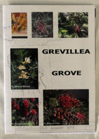
Book, Grevillea Grove, 2017
... this parcel of crown land for a Rainforest Garden and Information... this parcel of crown land for a Rainforest Garden and Information ...This book was compiled and published in 2017. The contents are based on a scrapbook and photographs compiled by Margaret Kleinitz who was Secretary of the Orbost Garden Club during the time when Grevillea Grove was proposed and developed from1979-1989. The development of this garden in a disused quarry in Orbost involved a substantial community campaign and on-going effort, particularly from members of the Garden Club. The demise of Grevillea Grove came when the Vic. Govt. decided to develop this parcel of crown land for a Rainforest Garden and Information Centre. Local resident, Audrey Van Den Berg has compiled this book. Shows the effort and dedication involved in this community project.A 40 page book with cardboard cover. Front cover has 6 colour photos of Grevillea plants overlaid onto a plan of the Grevillea Grove garden. This book contains b/w photographs and a written history of the creation of the Grevillea Grove garden in Orbost. It also has site plans and newspaper articles.GREVILLEA GROVE grevillea grove, orbost -
 Orbost & District Historical Society
map/poster, Victorian Government Printer, 22.4.1926
... . It was responsible for the management of the State's Crown land and pastoral.... It was responsible for the management of the State's Crown land and pastoral ...The Department of Crown Lands and Survey was originally established in 1857 as part of the Board of Land and Works. In 1964 it ceased to be controlled by the Board. The Department functioned for almost twenty more years before being combined with other Ministries to form the Department of Conservation, Forests and Land. It was responsible for the management of the State's Crown land and pastoral estates. This map was used by Don Mehlert after 1928. The VERMIN AND NOXIOUS WEEDS ACT 1928 was an Act to consolidate the Law relating relating to Vermin and Noxious Weeds. E. J. E. G. Pemberton who published this poster was Superintendent of Field Staff, Dept. of Lands and Survey. This map and posters are significant records of early settlement history in Murrangower, between Cabbage Tree and Orbost,A paper map of Murrangower showing settlement subdivisions. This is glued onto the back of four overlapping cloth poster of "Notices of Vermin Destruction". All print is black."DON MEHLERT" in black pen. Pike's block shaded in blue. School site marked in blue pencil. on poster "MURRANGOWAR" along side.map-murrangower poster-vermin-and-noxious-weeds murrangower-settlement -
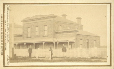 Bacchus Marsh & District Historical Society
Photograph, Court House Main Street Bacchus Marsh 1883
... and a Crown Land sales office. Other uses included an office... and a Crown Land sales office. Other uses included an office ...The Court House in Main Street Bacchus Marsh was built in 1858 using local sandstone. It opened in 1859. It has been used for jury trials, a Court of Petty Sessions, a County Court and a Crown Land sales office. Other uses included an office for the Registrar of Births and Deaths, a Dairy Inspectors office from 1863-1865, and as meeting rooms for the Bacchus Marsh Roads Board, a forerunner of the Shire Council. It was also used by the Bacchus Marsh Shire Council for its offices until at least 1884. In more recent years it has functioned as a Magistrates Court with weekly court sessions. Small sepia unframed photograph on card with gold border framing photograph. Housed in the album, 'Photographs of Bacchus Marsh and District in 1883 by Stevenson and McNicoll'. The view of the Court House building is seen from the northern side of Main Street looking south or south-east. Three men are standing in the street in front of the building. The men on the left and the right wearing police helmets appear to be police officers. The man in the middle is in civilian clothes and might be an officer or employee of the Court House. He has his dog with him. A white picket fence runs along the front of the building. The front courtyard of the building has been renovated since, but this building still operates as a court house.On the front: Stevenson & McNicoll. Photo. 108 Elizabeth St. Melbourne. COPIES CAN BE OBTAINED AT ANY TIME. On the back: LIGHT & TRUTH inscribed on a banner surmounted by a representation of the rising sun. Copies of this Portrait can be had at any time by sending the Name and Post Office Money Order or Stamps for the amount of order to STEVENSON & McNICOLL LATE BENSON & STEVENSON, Photographers. 108 Elizabeth Street, MELBOURNE. stevenson and mcnicoll 1883 photographs of bacchus marsh and district, courthouses, bacchus marsh court house