Showing 188 items
matching dirt road
-
 City of Kingston
Photograph - Black and white, c. 1958
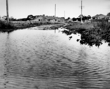
... in Beaumaris, located off Balcombe Road. Roads in the Beaumaris area...City of Kingston Parkdale Library 96 Parkers Road, Parkdale ...This photograph depicts flooding of Ozone Avenue in Beaumaris, located off Balcombe Road. Roads in the Beaumaris area lacked sufficient drains to clear surface water. In many cases streets were unsealed and without footpaths and some were dirt tracks. Gutters and road surfaces were made of clay and in the wetter months of winter, unsealed roads and tracks became impossible quagmires that were unnavigable for vehicles and pedestrians. In the first decade after World War II there was rapid expansion in construction of new houses in the suburb of Beaumaris. Utilities and infrastructure to support the growth of housing was inadequate and not provided for prior to the development of the area. Without rudimentary drainage, flooding was frequent. Storm water runoff, domestic sullage and septic tank overflow would form large pools and families were sometimes marooned within their homes. The frequent flooding caused isolation and hardship and residents endured difficulties with accessibility to facilities. These disadvantages had the potential to cause social issues for the new residents.Black and white photograph of flooding in Ozone Avenue, Beaumaris. The image shows floodwaters with boggy and rough terrain on an unsealed road with housing in the distance.Handwritten in blue ink: 2124 circled Handwritten in red ink: 80% Handwritten in blue ink on yellow Post-It note: Chap 6. underlined, 2194 Ozone Ave Beaumaris 1958beaumaris, ozone avenue, balcombe road, flooding, roads, infrastructure -
 Bendigo Historical Society Inc.
Photograph - WES HARRY COLLECTION: CNR. WILLIAM STREET, THEATRE ROYAL, KRONHEIMER & CO
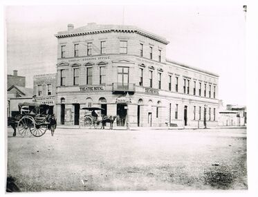
... , tobacconists' Road is dirt. Two horse and carriages on LH side on road.... of Theatre ' J. Kronheimer & Co, tobacconists' Road is dirt. Two ...Black and white image, copy : Image shows three storey stone building on corner of Williamson street and High Street. Name on lower storey 'Theatre Royal' on top ' Cobb & Co., Booking Office' on LH side of Theatre ' J. Kronheimer & Co, tobacconists' Road is dirt. Two horse and carriages on LH side on road.Batchelderplace, bendigo, theatre royal, kronheimer's, sandhurst, bendigo, theatre royal, cobb & co, kronheimer & co. -
 Eltham District Historical Society Inc
Photograph - Digital Photograph, Marguerite Marshall, Jelbart home, 93 Arthur Street, Eltham, 11 November 2006
... was then at the end of a dirt road, Arthur Street. With post war shortages... was then at the end of a dirt road, Arthur Street. With post war shortages ...Situated at the top of the hill in Arthur Street, the former Jelbart residence and barn were part of a major change that transformed Eltham's character in the late 1960s. Built from the mid 1940s through mid 1950s when Eltham was a rural community, the Jelbrat residence and barn are all that remain of a family property of some 250 acres (100 ha). With growing population pressures, in the late 1960s, owners Ron and Yvonne Jelbart decided to subdivide their property creating the Woodridge Estate in the early 1970s, a major factor towards the transformation of Eltham to the suburb it is today. The Jelbarts had moved to Eltham in the early 1940s when they purchased a poultry farm in New Street, now Lavendar Park Road. (The local Black Friday bushire of January 13, 1939 had started at C.A. (Clarrie) Hurst’s Eltham Poultry Farm and Hatchery in New Street.) Jelbart was primarily a businessman importing office machinery but desired farm beef and dairy cattle so the couple purchased the virgin bushland at what was then at the end of a dirt road, Arthur Street. With post war shortages of most building materials, they followed the example of the Eltham Artists' Colony (later called Montsalvat) and built thier home from mud-bricks and recyclked materials. The barn was first to be completed in 1945 which they made their home whilst building the main residence. It took eight years to complete the two buildings. Both the main residence and the barn are now separate homes, and along with the remaining property being sub-divided further in 1998 are now part of the Kinloch Gardens Estate at 93 Arthur Street. Covered under Heritage Overlay, Nillumbik Planning Scheme. Published: Nillumbik Now and Then / Marguerite Marshall 2008; photographs Alan King with Marguerite Marshall.; p139 Standing on a hilltop at Arthur Street, Eltham, the Jelbart residence and former barn were part of a major change that transformed Eltham’s character in the late 1960s. Built from the late 1940s to the mid 1950s when Eltham was a rural community, they are all that remain of what was once a family property of around 250 acres (100 ha). As population pressure increased in the late 1960s, owners Ron and Yvonne Jelbart, decided to subdivide their property. The break-up of this property into the Woodridge Estate in the early 1970s, was a major factor towards transforming Eltham into the suburb it is today.1 Although standing only a few minutes from Eltham’s busy hub and hundreds of houses in Woodridge, scarcely any urban sound disturbs the peace. Views from the two buildings are almost exclusively of trees and extend to Mt. Dandenong to the south-east, the Great Divide to the north, and Melbourne city to the south-west. The Jelbarts had lived in Eltham since the early 1940s when they bought a poultry farm in New Street, now Lavender Park Road. Although Jelbart was primarily a businessman importing office machinery, he was keen to farm dairy and beef cattle, so the couple bought rough bushland at what was then the end of Arthur Street. But a shortage of building materials following World War Two hampered their plans to build their new home, so they followed the example of the Eltham Artists’ Colony (later called Montsalvat) and used mud-bricks and recycled materials.2 With great determination the family and friends constructed their house. Massive timber frames and huge quantities of mud-bricks were made on site. The barn was built first in 1945, and two years later, while camping inside, the Jelbarts started building their house. It took eight years to construct the two buildings, even with the help of professional tradesmen. The buildings, with timber frames infilled with mud-brick and plastered, are reminiscent of the English Tudor style. The Jelbarts are of Cornish stock. Much of the timber framework came from demolished bridges or warehouses, and recycled slate was used for roofs and floors. Quality second-hand materials were readily available in the late 1940s and 1950s when there was much demolition in Melbourne and little respect for heritage. A former 19th century Toorak mansion Woorigoleen provided the magnificent stone fireplace, the timber panelling and the parquetry floor in the living room. The large stone gateposts at the entry of the property came from Melbourne University. Almost no mechanical equipment was used to build the 55 square house and the 25 square barn. Massive timber frames were erected using block and tackle pulleys and timbers were shaped, sawn and drilled by hand. Son and architect Ian, with his family, have lived in and extensively renovated both buildings since the early 1970s. Ian transformed the steep ridge of the property into a plateau, where the main house Kinloch stands, surrounded by terraces and lawns. The grounds retain many native plants, including massive yellow boxes – some nudging 80 years. Ian attached 70 metres of pergolas draped with wisteria, roses and grape vines, to three sides of the house. The beautiful garden is featured in the book Through the Rose Arbour by Rosemary Houseman. The two-storey barn – now a house – retains traces of its original use. The cow-shed with milking and feed-rooms, and the machinery-shed remain. The house, separated on the ground floor by a breeze-way, soars two storeys and includes a mezzanine. These are connected by spiral staircases, to timber-beamed and plaster-lined high-pitched ceilings. The house also descends to a wine cellar. Curiously the roof is of corrugated iron on the south and slate on the north, to save costs. Small-paned windows and three French doors open onto the front lawn, which extends to Jelbart Court.This collection of almost 130 photos about places and people within the Shire of Nillumbik, an urban and rural municipality in Melbourne's north, contributes to an understanding of the history of the Shire. Published in 2008 immediately prior to the Black Saturday bushfires of February 7, 2009, it documents sites that were impacted, and in some cases destroyed by the fires. It includes photographs taken especially for the publication, creating a unique time capsule representing the Shire in the early 21st century. It remains the most recent comprehenesive publication devoted to the Shire's history connecting local residents to the past. nillumbik now and then (marshall-king) collection, eltham, arthur street, jelbart barn, jelbart home, kinloch gardens -
 Eltham District Historical Society Inc
Photograph, Woodburn residence, mudbrick adobe (1949), Eltham Heritage Tour, 24 May 1992, 24/05/1992
... homes', mud-brick or pise, rammed dirt. Crossing Main Road... with a sprinkling of 'earth homes', mud-brick or pise, rammed dirt. Crossing ...ELTHAM HERITAGE TOUR The Society excursion on 24th May 1992 was arranged by David Bick, leader of the team carrying out the Shire's heritage study. David selected a number of sites or buildings identified in the study, some of them lesser known components of the Shire's heritage. The tour commenced at the Eltham Shire Office at 10.00 am. Travel was by private car and mini-bus with stops at about twelve locations for commentary by David.It included a short walk in Hurstbridge and lunch at Kinglake. Highlights of the tour included: - 10 am Leave from Shire Offices - 3 Important Trees - A Physical Link to Eltham's First Settlers - Toorak Mansion Gates - A Surviving Farm House - An Intact Circa 1900 Main Street - First Settlers - Gold Miners, and Timber-getters - An Early Hotel - A Pioneering Homestead - Changing Eltham Shire - 20th Century - 4 pm Afternoon Tea and Finish Tour Extract from ELTHAM CULTURAL HERITAGE TOUR (Newsletter No. 85, July 1992, by Bettina Woodburn) "In some respects Eltham is a 'back-water' and it has its own distinctive flavour. On the outskirts the homes date from the 1960's, 70's and 80s with a sprinkling of 'earth homes', mud-brick or pise, rammed dirt. Crossing Main Road into Beddoe Street and Thompson Crescent a very pleasant drive past pines and old fence lines, front lawns unfenced, the occasional ·old farm building, we eventually looked down on a huge circular roof of a 1992 adobe home. Other distinctive places included the Pauline Toner Butterfly Reserve, Gordon Ford's splendid garden at Fulling in Pitt Street, cypress hedges and old houses in Bridge Street and in every direction Eltham's special feature - a totally treed horizon. We were now in the part of the Shire closest to Melbourne - Montmorency - not on the way to anywhere, with no through road going across it, developed in the 1950's and 1960's with conventional gardens, now converted to native plants. The rail looped between Greensborough and Eltham and a shopping street (Were Street) served the area, growing up the hill from the station. It was a typical outer Melbourne suburb with lawns and roses with patches of originality. The shopping precinct still has 1950 characteristics - walls which sloped back, projecting roofs, the original shop fronts are nearly all tiled below the old windows. There's an air of past times about the School, the Dairy, the Butcher's (now a milk bar) and the Castlemaine stone face of the Commonwealth Bank. The final stop for the tour was at the mud-brick Woodburn residence, adobe of 1949 with additions. After War Service, Bill Woodburn had commenced an Architecture course at Melbourne University and after second year in the Christmas vacation, with his wife, Betti, built the two bedroom house - with amazing saving of costs. In the three and a half months they made over 3000 bricks (external walls 18" x 12" x 4", internal walls 12" x 9" x 4"), sifted top soil for mortar and laid them, on concrete foundations and slab floor, made all the structural window frames, door frames and roof members to carry 'super six' asbestos sheets, laboured for the electrician and plumber, did all the glazing and, still without electricity, moved in in March 1949. Rooms have been added, at first with glass walls, later using concrete blocks, to accommodate three daughters and a son. The house not only grew from the earth, but also with the family."Record of the Society's history and activities and highlighting various aspects of the Heritage Study undertaken by David Bick used to create the future heritage overlay for the Shire of Eltham and later Nillumbik Shire.Roll of 35mm colour negative film, 4 stripsKodak Gold 100 5095shire of eltham historical society, activities, heritage tour, woodburn house -
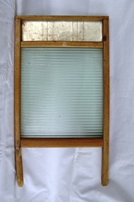
 Flagstaff Hill Maritime Museum and Village
Domestic object - Washboard, 1900-1930
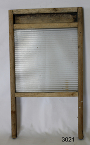
A washboard is a tool designed for hand washing clothing that are soaked in hot soapy water in a wash tub or sink, then squeezed and rubbed against the ridged surface of the washboard to force the cleaning fluid through the cloth to carry away dirt. With the invent of mechanized cleaning of clothing becoming more common by with the use of washing machines by the end of the 20th century the washboard was soon discontinued. The traditional washboard is usually constructed with a rectangular wooden frame in which are mounted a series of ridges or corrugations for the clothing to be rubbed upon. For 19th-century washboards, the ridges were often of wood, sometimes glass and by the 20th century, ridges of metal became common The first "fluted" metal washboard was patented in the United States by Stephen Rust in 1833 and Zinc washboards were predominantly manufactured in the United States from the middle of the 19th century. A significant item for cleaning clothes still in use today in many countries giving a snapshot into the domestic life of a housewife into the 20th century.Washboard wooden frame with a ribbed glass sectionNonewarrnambool, shipwrecked-coast, flagstaff-hill, flagstaff-hill-maritime-museum, shipwreck-coast, flagstaff-hill-maritime-village, washboard, glass ripples, clothes cleaning, washing, laundry -
 Warrnambool and District Historical Society Inc.
Plaque, Warrnambool Co-operative Society Limited, 6 August 1976
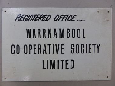
Rectangular white painted sign board with black text and a hole in each corner for attaching the sign to the wall. The sign has dirt on the surface and into the top right-hand corner. The signwriter's inscription in brown texta is on the back. Front: REGISTERED OFFICE .../WARRNAMBOOL/CO-OPERATIVE SOCIETY/LIMITED Back: GRANT PHILLIPS/Signs/WARRNAMBOOL/6-8-1976signwriters, grant phillips, business signs, warrnambool co-operative society limited -
 Kiewa Valley Historical Society
Projector - 'Pictoral' Bogong State School, 1925 - 1935
... was 14 km away over a dirt road that wound around the Victorian ...As Bogong State School was located in a remote area especially in winter when the weather and therefore the road isolated the school for an indefinite time, the school was provided with up to date equipment with a comprehensive library and educational films that wouldn't disadvantage the students. Educational films covered all subjects and areas of the curriculum. The projector was very modern at the time. The Society for Visual Education Inc was founded in 1919 as a for-profit educational publisher dedicated to the use of new technologies in teaching.This projector was used at the Bogong State School which opened in 1941 for the children of the employees of the State Electricity Commission of Victoria who were working on the Kiewa Hydro Electric Scheme. The school was outstanding as reported by the school inspectors regarding the education of the pupils which was also supported by new and modern equipment. The nearest school was 14 km away over a dirt road that wound around the Victorian mountains and often closed due to bad weather. Bakelite box holding a globe and a small black tin projector on brown rectangular bakelite base with 4 round rubber stands at each corner. It is able to be moved upwards from the front to adjust the height within a cm. The back is a tall irregular box shape with ventilation on 2 sides of the bottom and at the top. There is a brass plaque attached above 1 vent and an electric cord, with switch, below it. Attached at each side of the front of this box is a cylinder fitted horizontally facing the front where the lense is fitted. At right angles above there is another cylinder, hollow, with a rod for the film to be placed. Globe also in Bakelite boxPlaque: Pictorial Projector / Model Q / 120 Volts. 100 Watts / No. 23736 / Manufactured / Society of Visual Education Inc. / Chicago U.S.Aprojector, bogong primary school, education, educational films, visual education, kiewa hydro electric scheme -
 Kiewa Valley Historical Society
Tin Coffee and Chicory, circa mid to late 1900's
... had to contend with dirt roads, flooded roads, bush fires ...Chicory was mixed with coffee to reduce the amount of coffee bean required to be used. This coffee "substitute" was due to the repeated fluctuations in availability of coffee beans (and price fluctuations) in the USA in the late 1800s and early 1900s resulting in the search for substitutes and additives to bulk out the available supplies. This was especially so during times of the major World Wars. Chicory was an excellent choice of fillers as it did not greatly influence the strong coffee bean taste. The first choice in USA households was coffee not tea and the influence of the American servicemen's thirst for coffee was a major thrust into the Australian "colonial" preference for a "cuppa" tea. Rural areas took longer to acquire a coffee "break" but with more and more subliminal advertising through "American" films the rural regions developed a growing preference for coffee, however the tea break alias "smoko" has lingered on.This coffee and chicory blend tin container is very significant to the Kiewa Valley in that it demonstrates that even in rural regions of Australia tastes and drinking preferences have changed by subliminal advertising as time goes by. The American "influence" whether by the "invasion" of friendly troops during the major wars or the avalanche of "American films" has altered some of the "dinky-di" Australian "true blue" tastes and mores. The availability of "straight " coffee supplies to rural areas was also in proportion to the level of all weather transport routes. In the late 1800's and early 1900's road freight had to contend with dirt roads, flooded roads, bush fires and grazing cattle/sheep in rural areas. The easier access that city households had with regard to replenishment of food and drink products, up until the mid 1900's, was severely retarded in rural areas. This extensively rusted tin of "Bushells Blue Label" Coffee and Chicory has an octagonal shaped body with a "push/pull" lid(tin).Three sides has reproduced painted ladies in "Roman dress" ladies picking the coffee beans. There is no reproduction of any chicory roots. There are two "Indian dressed" field workers(pickers) with turban head dress. On one side of the tin is "directions of use, net weight and manufacturer details."Bushells Coffee & Chicory", "NET 1-Ib. weight", " No. 144" "Under the Pure Food Act N.S.W. 1938" "by Bushells Ltd. No 144"chicory / coffee drinks, tin hydrated drink, rural food and drink consumption patterns, tinned food and drink -
 Warrnambool and District Historical Society Inc.
Household, Scales - Grain tester, Early 20th century
This grain scale tester was used to work out the percentage weight of a sack of grain after the grain husk, dust and dirt were removed, thereby allowing for the calculation of the true value of the sack. The parts were attached to the box via the screw on top of the box and the cleaned grain went into the funnel to measure a fixed grain amount, before being released from the bottom of the funnel into the barrel which was then hung on the end of the scale. The weight was then slid down the graduated ruler until the scale balanced. Grain scale testers would have been used in farming in the Western District in the past and similar objects may still be in use. This grain scale tester is retained as a good example of an agricultural item from the past.This is a grain tester scale in a wooden box. .1 The wooden box has two metal hinges and wooden inserts inside with blue felt on the tops of the inserts. The box has a metal plaque on the lid and a round metal hole section for inserting a piece of equipment. .2 This is a metal flask on a stand. Part of it is rusty. .3 This is small metal cylinder with a lid. .4 This is a metal bar with measurements, a hook at the top and a slide or weight fitting on to the bar. .5 This is a small metal screw. ‘Lbs per bushel’ ‘Australian Manufacture by Australasian Scale Co. Ltd., Thomas Street, Sydney N.S.W.’ agricultural instruments, history of warrnambool, grain scale tester -
 Warrnambool and District Historical Society Inc.
Rake, Early 20th century
This rake is an adaptation of an old pitch fork for a specific purpose, perhaps for breaking up clods of dirt or doing some deep raking. This rake has no known local provenance but is kept for display purposes as an interesting example of an adaptation of an agricultural tool for a specific purpose. This is an old pitch fork which has been made into a rake or a scarifier by bending back the ends of the three metal prongs of the fork (producing prongs of an uneven length). The prongs are attached by a metal band to a wooden handle.vintage agricultural implements, history of warrnambool, pitch fork -
 Eltham District Historical Society Inc
Photograph, Fay Bridge, Clifton Pugh's Artists' Colony, Dunmoochin, Barreenong Road, Cottles Bridge, c.1995
Visit to Dunmoochin prior to Clifton Pugh's home being destroyed by fire in 2002. Following military service in the second world war, Clifton Pugh studied under artist Sir William Dargie at the National Gallery School in Melbourne as well as Justus Jorgensen, founder of Montsalvat. For a while he lived on the dole but also worked packing eggs for the Belot family saving sufficient to purchase six acres (2.4 ha) of land at Barreenong Road, Cottles Bridge. He accumulated more land and persuaded several other artists and friends to buy land nearby, resulting in a property of approximately 200 acres, stablishing it as one of the first artistic communes in Australia alongside Montsalvat in Eltham. It was around 1951 that Pugh felt he had '"done moochin' around" and so the name of the property evolved. He bought timber from Alistair Knox to build his house on the crest of a hill. Inspired by local goldminer's huts, it was a one room wattle-and-daub structure with dirt floor. Over the years it expanded with thick adobe walls made from local clay, high ceilings and stone floors. All materials other than the local earth were sourced from second hand materials, most found at wreckers' yards. Artists from across the nation were drawn to Dunmoochin, with several setting up houses and shacks on the property, maintaining their independence but sharing their artistic zeal. Artists who worked or resided at Dunmoochin included Mirka Mora, John Perceval, Albert Tucker, Fred Williams, Charles Blackman, Arthur Boyd and John Olsen. In 2002, Pugh's house along with its treasure trove of art and a library of some 20,000 books was destroyed by fire. Traces of Pugh's home remain with the presence of the Victorian doorframe archway with leadlight of intricate design, procured from a demolished Melbourne mansion; and two bronze life-sized female statues created by Pugh and cast by Matcham Skipper. In place of Pugh's house rose two double-storey mud-brick artists' studios topped with corrugated iron rooves curved like the wings of a bird with accommodation for seven. The original studios, gallery and other buildings survived the fire.fay bridge collection, 1995, barreenong road, cottles bridge, dunmoochin -
 Eltham District Historical Society Inc
Photograph, Fay Bridge, Clifton Pugh's Artists' Colony, Dunmoochin, Barreenong Road, Cottles Bridge, 14 May 2016
Following military service in the second world war, Clifton Pugh studied under artist Sir William Dargie at the National Gallery School in Melbourne as well as Justus Jorgensen, founder of Montsalvat. For a while he lived on the dole but also worked packing eggs for the Belot family saving sufficient to purchase six acres (2.4 ha) of land at Barreenong Road, Cottles Bridge. He accumulated more land and persuaded several other artists and friends to buy land nearby, resulting in a property of approximately 200 acres, stablishing it as one of the first artistic communes in Australia alongside Montsalvat in Eltham. It was around 1951 that Pugh felt he had '"done moochin' around" and so the name of the property evolved. He bought timber from Alistair Knox to build his house on the crest of a hill. Inspired by local goldminer's huts, it was a one room wattle-and-daub structure with dirt floor. Over the years it expanded with thick adobe walls made from local clay, high ceilings and stone floors. All materials other than the local earth were sourced from second hand materials, most found at wreckers' yards. Artists from across the nation were drawn to Dunmoochin, with several setting up houses and shacks on the property, maintaining their independence but sharing their artistic zeal. Artists who worked or resided at Dunmoochin included Mirka Mora, John Perceval, Albert Tucker, Fred Williams, Charles Blackman, Arthur Boyd and John Olsen. In 2002, Pugh's house along with its treasure trove of art and a library of some 20,000 books was destroyed by fire. Traces of Pugh's home remain with the presence of the Victorian doorframe archway with leadlight of intricate design, procured from a demolished Melbourne mansion; and two bronze life-sized female statues created by Pugh and cast by Matcham Skipper. In place of Pugh's house rose two double-storey mud-brick artists' studios topped with corrugated iron rooves curved like the wings of a bird with accommodation for seven. The original studios, gallery and other buildings survived the fire.fay bridge collection, 2016-05-14, art gallery, barreenong road, clifton pugh, cottles bridge, dunmoochin, maurice hurry -
 Eltham District Historical Society Inc
Slide - Photograph, Nyora Road, Eltham, c.1993
The east end of Nyora bewteen Stokes Place and Reynolds Road was unsealed. This section was only a fire access track as evidenced by the trees growing in the middle of the road. Real Estate agents would advertise homes as down a (dusty) country lane. The Nyora Road Resident Action Group arose to address concerns with Council regarding the dangerous conditions and traffic from outside the area using it as a 'rat-run' to avoid Main Road. Council traffic monitors showed that the amount of traffic was only 20% less than that of Mt Pleasant Road. The Action Group wanted the road closed at reynolds Road however Council elected to install speed calming devices along the sealed section between Stokes Place and Eucalyptus Road. Chicanes were added at several locations and a roundabout installed at Stokes Place in 2004. This remaining dirt section was sealed post 2004.35mm colour positive transparency Mount - Black and Whiteinfrastructure, roads, eltham, nyora road -
 Eltham District Historical Society Inc
Work on paper (item) - Photograph, 2 Metery Road, Eltham South
Robert and Ada Zull built an Alistair Knox designed house at 2 (lot 8) Metery Road, Eltham, a one acre property for their family of five in the mid 1960s. The cleared block is an expanse of dirt with wheel tracks, with trees and bush in the background and piles of rocks on the right hand side. Susan Bennett, nee Zull's reminiscences are published in EDHS Newsletter, February and April 2020. ".. the block was big.. Building the house was slow going. The plans had to be discussed, then drawn up, finance found, council permits obtained and labourers engaged. " This series of photographs together with the account of personal remiscences provide a unique document of the construction of an Alistair Knox designed home. Knox was a pioneer in the use of mudbricks and recycled materials and is significant to his contribution of this style of architecture in Eltham and the wider Shire of Nillumbik.zull family, clearing, eltham south, 2 metery road, alistair knox -
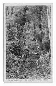 Marysville & District Historical Society
Postcard (item) - Black and white postcard, Rose Stereograph Company, The Talbot Drive, Marysville, Victoria, 1913-1967
... is an improvement over impassable mud or dirt roads, yet rough in the best ...A postcard in a series produced by the Rose Stereograph Company in Victoria, Australia as a souvenir of Marysville.Lady Talbot Drive (Talbot Drive) is a 24 kilometer scenic rainforest car journey which passes a number of walks and waterfalls in the Yarra Ranges National Park. Lady Talbot Drive is named after Lady Sarah Elizabeth, the wife of Sir Reginald Talbot, who was the Governor of Victoria from 25th April, 1904 to 6th July 1908. This road was originally constructed as a corduroy road (or log road) is a type of road or timber trackway made by placing logs, perpendicular to the direction of the road over a low or swampy area. The result is an improvement over impassable mud or dirt roads, yet rough in the best of conditions and a hazard to horses due to shifting loose logs.POST CARD REAL PHOTO THE "ROSE" SERIES DE LUXE PRODUCED IN AUSTRALIA PUBLISHED BY "THE ROSE STEREOGRAPHS"/ Armadale, Victoria.talbot drive, lady talbot drive, lady talbot forest drive, sir reginald talbot, lady sarah elizabeth talbot, rainforest, marysville, victoria, rose stereograph company, p. 2340, postcard, souvenir, corduroy road -
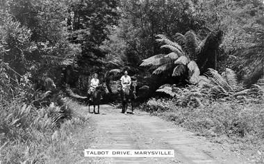 Marysville & District Historical Society
Photograph (item) - Black and white photograph, Talbot Drive, Marysville, Unknown
... is an improvement over impassable mud or dirt roads, yet rough in the best ...An early black and white photograph of Lady Talbot Drive in Marysville in Victoria.Lady Talbot Drive a 24 kilometer scenic rainforest car journey which passes a number of walks and waterfalls in the Yarra Ranges National Park. Lady Talbot Drive is named after Lady Sarah Elizabeth, the wife of Sir Reginald Talbot, who was the Governor of Victoria from 25th April, 1904 to 6th July 1908. This road was originally constructed as a corduroy road (or log road) is a type of road or timber trackway made by placing logs, perpendicular to the direction of the road over a low or swampy area. The result is an improvement over impassable mud or dirt roads, yet rough in the best of conditions and a hazard to horses due to shifting loose logs.lady talbot drive, lady talbot forest drive, marysville, victoria, sir reginald talbot, lady sarah elizabeth talbot, corduroy road -
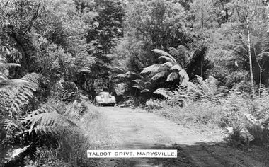 Marysville & District Historical Society
Photograph (item) - Black and white photograph, Talbot Drive, Marysville, Unknown
... over impassable mud or dirt roads, yet rough in the best ...An early black and white photograph of Lady Talbot Drive in Marysville in Victoria.An early black and white photograph of a car traveling along Lady Talbot Drive in Marysville in Victoria. Lady Talbot Drive a 24 kilometer scenic rainforest car journey which passes a number of walks and waterfalls in the Yarra Ranges National Park. Lady Talbot Drive is named after Lady Sarah Elizabeth, the wife of Sir Reginald Talbot, who was the Governor of Victoria from 25th April, 1904 to 6th July 1908. This road was originally constructed as a corduroy road (or log road) is a type of road or timber trackway made by placing logs, perpendicular to the direction of the road over a low or swampy area. The result is an improvement over impassable mud or dirt roads, yet rough in the best of conditions and a hazard to horses due to shifting loose logs.marysville, victoria, lady talbot drive, lady talbot forest drive, sir reginald talbot, lady sarah elizabeth talbot, corduroy road -
 Greensborough Historical Society
Domestic object - Washboard, 1900 c
Used in laundering clothing etc. Item would be rubbed against corrugations to remove ingrained dirt.Unpainted wooden framed washboard, clear glass corrugated on one side, with metal insert in top of frame.washboards, laundry, laundry equipment -
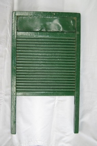 Greensborough Historical Society
Domestic object - Washboard, 1900 c
Used in laundering clothing etc. The corrugated section used to remove ingrained dirt by rubbingWooden washboard, corrugated both sides, painted greenwashboards, laundry, laundry equipment -
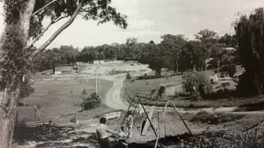 Greensborough Historical Society
Photograph - Digital Image, Petrie Park Montmorency 1960s, 1960s
Petrie Park Montmorency, 1960s. This photograph shows the early development of Petrie Park, showing a dirt track to the oval and children's play equipment in foreground. The park is situated in Mountainview Road. Today the Montmorency Eltham RSL is also located in Petrie Park.Digital copy of black and white photographpetrie park montmorency, mountainview road montmorency, montmorency eltham rsl -
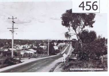 Greensborough Historical Society
Photograph, Approach to Greensborough, 1947c
... Greensborough Historical Society 34A Glenauburn Road Lower ...A vista of the top end of Greensborough in the late 1940's.Shows the development of Greensborough looking from the Melbourne approach side. Features the early power lines and post and wire fences along Grimshaw Street also dirt edges of the road, early street lighting and no footpaths.A black and white photograph of the approach to Greensborough in the late 1940's.Written in pen on back of photo: "Looking down Grimshaw St from the cutting near William St and Adeline Sts."greensborough, grimshaw street, post war era -
Glenelg Shire Council Cultural Collection
Photograph - Photograph - street scene, Portland, n.d
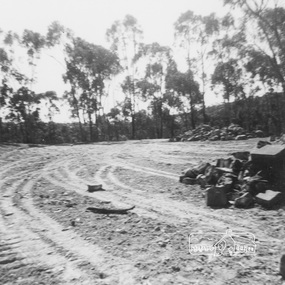
Black and white photograph of a dirt crossroads with factory in background.Back: Portland Development Committee (centre, blue stamp) -
Glenelg Shire Council Cultural Collection
Slide - Slide - Construction of Portland Airport, 1980s
Coloured slide. Excavator on left. Trench running north to south. Two men at excavator. Dirt pile to right of trench. Drainage hose in foregroundportland airport, cashmore, construction, portland development -
Glenelg Shire Council Cultural Collection
Photograph - Photograph - Casterton Victoria, n.d
Sourced from Casterton Town Hall (former Shire of Glenelg)Black and white photo. Dirt wall built across gully, round pipe through base of wall, small brick structure? remains of chimney on top of wallBack: Round, purple, photographer's stamp -
Glenelg Shire Council Cultural Collection
Slide - Slide - Construction Portland / Cashmore Airport, c. 1980
Vern Mc Callum CollectionColoured slide. Trench. Sky visible, top rear. Also bottom section of earth moving equipment, top edge of trench, left rear. Piles of dirt, pieces of timber, in trench. -
Glenelg Shire Council Cultural Collection
Slide - Slide - Construction Portland/Cashmore airport, c. 1980
Coloured slide, concrete retaining wall, end of ditch, on right. Frontend loader piling dirt against retaining wall, left. -
Glenelg Shire Council Cultural Collection
Slide - Slide - Cashmore Airport, Portland, 1980s
Coloured slide. Excavator loading dirt onto truck at the Cashmore Airport construction site.portland airport, cashmore airport, engineering, construction -
Glenelg Shire Council Cultural Collection
Slide - Slide - Cashmore Airport, Portland, 1980s
Coloured slide. Concrete pipe on bottom of hole, partly covered by dirt.portland airport, cashmore airport, construction, site -
Glenelg Shire Council Cultural Collection
Print - Contact Print - Dutton Way, 1960-1979
Black and white contact print from glass plate negative. Image shows Dutton Way beach with fence and dirt track along top of beach, horse tied up to fence. Looking east. -
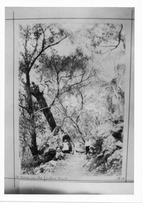 Halls Gap & Grampians Historical Society
Photograph - B/W, C 1898
The picture shows Maggie Galbraith and five small children (identities unknown) beside a jinker track (bridal path) near Halls Gap.A woman and five small children, two boys and three girls, on a dirt track with trees and rocks on either side of it.access routes, jinker track, people, galbraith