Showing 266 items
matching early residences
-
 Port Melbourne Historical & Preservation Society
Photograph - View from upper deck to deck of Chaplain's quarters, Mission Arts Centre, Missions to Seamen buiding, Port Melbourne, Alison Kelly, c. 1988
One of thirty photos taken by Alison Kelly at the Mission Arts Centre, late 1980s, early 1990s. Some with captions. Many have copies already in collection. View from upper deck to deck of Chaplain's quarters, showing mural and one of the artists in residence who shared this wingmissions to seamen, arts and entertainment, mission arts centre -
Port Melbourne Historical & Preservation Society
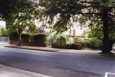
Photograph - Methodist Church, Farrell Street during conversion to residence, Jan 2002
Two (2) colour photographs of the old Methodist church at Farrell Street West, later ? church. Showing the early stages of re-building as a private residence in Jan. 2002.religion - primitive methodist church, farrell street west -
Port Melbourne Historical & Preservation Society
Photograph - Crowds on Centenary Bridge for Tall Ships bicentennial celebration, Port Melbourne, Alison Kelly, Jan 1988
One of thirty photos taken by Alison Kelly at the Mission Arts Centre, late 1980s, early 1990s. Some with captions. Many have copies already in collection. Crowds on Centenary Bridge for Tall Ships Bicentennial celebration, 1 January 1988; Mission sign in foreground, artist-in-residence Euan Cameron spruikingDetails on back in pencilmissions to seamen, arts and entertainment, celebrations fetes and exhibitions, mission arts centre, harry bocquet, brian couldrey -
Port Melbourne Historical & Preservation Society
Photograph - Artist-in-residence, Euan Cameron, Mission Arts Centre, Missions to Seamen buiding, Port Melbourne, Alison Kelly, 13 Dec 1988
One of thirty photos taken by Alison Kelly at the Mission Arts Centre, late 1980s, early 1990s. Some with captions. Many have copies already in collection. Artist-in-residence Euan Cameron working on a painting of the First Fleet during the Community Open Day at the Mission, December 1987.'Euan Cameron' in aqua ink on backmissions to seamen, arts and entertainment, celebrations fetes and exhibitions, mission arts centre, euan cameron -
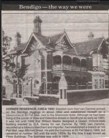 Bendigo Historical Society Inc.
Newspaper - JENNY FOLEY COLLECTION: CORNER RESIDENCE CIRCA 1900
Bendigo Advertiser "The way we were" from 1999. Corner residence circa 1900: Swedish born Karl Van Damme arrived on the Bendigo diggings in about 1852 and established himself as a tobacconist at 85 Pall Mall, next to the Shamrock Hotel. Although he had been living at the corner of View and Valentine streets in Sandhurst as early as 1883 it was not until 1898 that William Beebe designed a Queen Victoria style building erected by G.A. Davey for Van Damme. By 1905, van Damme, recorded as a tobacco merchant and importer, had established a branch at 143 Pall Mall, near Mitchell street. He sold the business at 85 Pall Mall in 1909, but remained at number 143 until the early 1920s. By this time it was known as Pikes Buildings. The business was sold in 1924newspaper, bendigo advertiser, the way we were -
Winchelsea and District Historical Society
Photograph, Old wooden bridge and New Bluestone Bridge circa 1867
photograph taken circa 1867/8 Original wooden bridge built about 1857Photo of Blue stone bridge, as is today This photo is important, shows Winchelsea before many buildings.Very early Winchelsea circa 1867/8.photo taken from opposite old Library. Early wooden bridge right foreground and present bluestone bridge centre foreground. First Shire Hall and Dr. Meyler,s residence right above wooden bridge. On the left is Stirling's StoreOld wooden Bridge and New Bluestone Bridge circa 1867. Winchelsea Shire Hall top right (First Shire Hall).bridge, dr. meyler, stirling's store, first shire hall, wooden. -
Tatura Irrigation & Wartime Camps Museum
Photograph - copy, D. Clark, Tatura Buildings, 1989 copy
Photograph of buildings in Tatura. Later Wilson's garage and residence, flour mill and possibly Brady's store in Casey Street. Lake in background. Was originally a post card.Black and white copy photograph of early scene of Tatura businesses.on back: south view Tatura. Lake in backgroundtatura victoria -
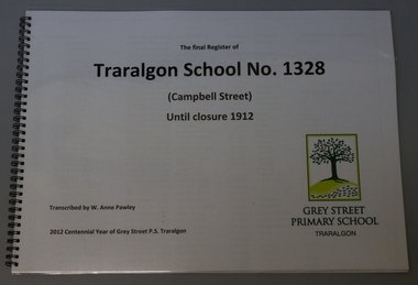 Grey Street Primary School, Traralgon
Book, spiral bound, The final Register of / Traralgon School No. 1328 / (Campbell Street) / until closure 1912, 2011
This pupils register transcription covers the enrolment years 1900 - July 1910, for pupils numbered 1 - 978. The columns include Register number, Name, DOB, Date of Admission, Name of Parent/Guardian, Residence of Parent/Guardian, Occupation of Parent/Guardian, School last attended. The transcription minimises the need for handling of the original. A recorded register number from an earlier register (s) is noted on the original and listed in an extra column. campbell st, traralgon, pupils, register -
 Tatura Irrigation & Wartime Camps Museum
Photograph, Mill House
THE MILL HOUSE- Albert Street, Tatura.|Reilly®s Flour Mill operated in Tatura from 1880 to 1965. The mill was demolished in 1966. James Reilly emigrated from County Cork, Ireland, spent two years on a family farm at Fitzroy, another two years at a mill at Kilmore, and then to Murchison to build a mill. Some of his family came to Tatura to build a mill. The house was built for members of the family to live in at various times. After the mill was demolished the house remained as a residence on about the only hill in Tatura. In the late 1970®s, early 1980®s a doctor added several upstairs rooms, then in the late 1990®s the house was used as a bed and breakfast. It is now a private residenceColoured photo taken Sept. 2004.mill house, albert street, tatura, photography, photograph, slides, film -
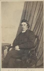 Uniting Church Archives - Synod of Victoria
Photograph, Rev. Charles Same/Sane, Undated c.1870
Rev Charles Lane (1823 - 1910) Wesleyan Methodist minister. The Observer 15 January 1910, p.36: The Rev. Charles Lane, better known In South Australian Methodism as "Father" Lane, died at his residence, Dorset Cottage, Magill, on Saturday, at the advanced age of 88 years. The deceased clergyman attended the Methodist Conference in 1900 —the year of his jubilee as a minister--and was accorded a vote of congratulation. Mr. Lane was born in Dorset, and be associated himself with the Congregational Sunday school at an early age, and when 16 years old took a practical part in religious matters. Then he removed to another town and joined the Methodist Church. In 1855 a request for a number of energetic Christian workers came from Australia, and 10 were sent out in the ship Walmer Castle, among the number Mr. Lane. He was received into the Victoria ministry in the following year, and received his first - charge at Ballarat. He proved a successful preacher in the early days of the Victorian goldfields, and accomplished much valuable work. He was impressive in the pulpit, humorous on. the platform, and welcome everywhere. About 1878 he wag transferred to the South Australian Conference, and from that time until being placed on the supernumerary list in 1889. he laboured in all the most important circuits. He was President of the Wesley an Conference in 1886, and displayed conspicuous ability in fulfilling the important duties associated with that office. He had resided at Magill for 17 years, and up to the time of his death had evinced a deep interest in work to which he had devoted .the best years of his life. Sepia toned carte de visite: seated studio portrait of the Rev. Charles LaneRev Chas Lanerev charles lane, methodist, minister, south australia -
 University of Melbourne, Burnley Campus Archives
Photograph - Black and white print, Information Branch, Victorian Department of Agriculture, Principal's House, 1900-1909
Therefore the earlier comment about seated man would not be correct.2 copies black and white photograph. House and surrounding garden. Building is of stucco and timber, slate roof, 4 chimneys. The original sections of the house date from 1872. The seated gentleman on a bench in front of the house is probably Mr. E.E. Pescott.Reverse of larger copy, "from box the Garden/Land 1909." On reverse of smaller copy, "Photograph by Information Branch Victorian Department of Agriculture Ref. No. 1981(889-2.)" Further copy: handwritten on reverse, "Early 1900 certainly before 1909. Caption "Directors residence (1909) was a major feature of the garden. sadly it was demolished in 1980 now leaving none of the early college buildings outstanding." In different handwriting, "Principals House before 1909."e.e. pescott, principal's residence, principal's house -
Nillumbik Shire Council
Prints (solar etchings): Christine JOHNSON (b. 1959 AUS), Voyages Botanical, 2014
Johnson undertook this project with a State Library of Victoria 'Creative Fellowship' in 2012, drawing on early botanical illustrations by Sydney Parkinson, Pierre-Joseph Redoute, Ferdinand Bauer and others from the Library's 'Rare Books' Collection. Johnson printed this series in 2013 while working as artist in residence at Baldessin Press, St. Andrews. 'Voyages Botanical' celebrates the untamed treasures of Australia’s (Nillumbik) vast native flower garden. The work speaks to Nillumbik's natural environment and colonial heritage in the context of our national story. Charcoal solander box with artwork title, artist name and flower motif in silver lettering bottom centre (edition 4/5). Catalogue: 52 colour pages. Solar plate engravings x 30; ink on paper. Series A: Ten multi-layered solar plate engravings (edition of 12); Series B: Ten flower images drawn from living specimens (edition of 12); Series C: Ten details from early botanical art engravings (open edition) Charcoal solander box with artwork title, artist name and flower motif in silver lettering bottom centre. Solar plate engravings x 30: Series A, B: all prints have edition number '4/12' to bottom left of image, artwork title () centre and artist signature 'Christine Johnson 2014' to bottom right of image. Series C: all prints have artist initials signed 'CJ' bottom right of images. All inscriptions in pencil. johnson, solar plate, engravings, creative fellowship, baldessin press, state library of victoria, botanical, flora, native, european explorers, cartography, wildflowers -
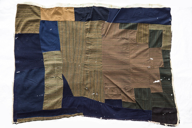 National Wool Museum
Quilt, 1880s
The wagga was owned by the great uncle of the donor's husband, George Stephens. Mr Stephens was a mining engineer in the late 1800s to early 1900s in Stawell, Main Lead (near Beaufort), Diamond Creek and Costerfield in Victoria. His last residence was at Bosterfield, where the wagga was used as a bed quilt in the mid 1940s. It may have also been used in the childhood home of Mr Stephens at Stawell. Mr Stephens saved the life of a blacksmith at Diamond Creek Gold Mine circa 1910.A wagga made from men's suits and coats, unpicked and sewn together. Pieces are in blue, brown checked and striped materials. There are remnants of a backing around the edges.wagga, running stitch collection, diamond creek, victoria, stawell, beaufort, costerfield -
 Stawell Historical Society Inc
Photograph, Armstrong’s Area Houses c 1990's -- 2 Photos -- Coloured
Residence Fountainhead Brewery Armstrong's Est. c 1872. The rear view photograph shows a more recent renovated building. Some evidence of demolition to rear of building (servants stairs etc.) Following notes taken from information in album 9 - "Compare earlier photos and note balcony etc. Later views, This photo early 2003. Owing to timber decay balcony was removed for safety. Finances permitting complete balcony will be replaced. Twin columns and iron lace are not original. Early description mentions statues in "niches" beside door. Female statue left is original. White pedestal at left was male stature damaged by a falling tree. Both statues were fountains." Photographs taken by Mr. Don Richard and held in Album 9b Armstrong’s Area.Two coloured photographs, of a brick double story building. The front view of the building has 4 windows and 2 doors. Two white columns at the entrance with decorative iron work support the roof of the porch with 2 white chairs and a table on top. Either side of the entrance door are 2 white wall indents "niches" with pot plants. The second photo show the back view of the two story building with a single story building attached that has a tin roof. A timber fence with a gate shows the side entrance to the single story building. 648M NHNN 8H01HPRO3 WIMMERA 1MHGINGstawell -
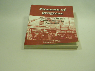 Inglewood & District Historical Society
Catto Family Book, Cambridge Press, Pioneers of Progress - Jennifer Lovell & Norma Catto, 2007
... in the early 19th century. John Catto (1802-1872) and John Catto (1830 ...Relating the story of two branches of the Catto family who emigrated to Australia in the early 19th century. John Catto (1802-1872) and John Catto (1830-1918) Detailed history of the early settlement and continued residence of the Loddon district by the Catto family (many references to other families also)Soft cover book. 266 pages. Red and white photographic cover. History of two Catto families in Loddon District.ISBN 9780646476766. Limited Edition 2007 / Dedicated to the memory of Norma and Graeme Catto.catto early history in loddon -
 Rutherglen Historical Society
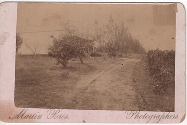
Photograph, Martin Bros, 1900 (Approximate)
Residence & vineyard bounded by Murray Valley Highway, Hunter Street & Carlyle. Planted by Thos. Reeve, an early settler of Rutherglen. Relatives still living (1985) Mrs Joan Ray, Rutherglen is a grand-daughterBlack & white postcard size sepia photograph, mounded on cardboard, of house and vineyardIn ink on back of photo: "Entrance to Vineyard / & Residence of T. Reeve / Orwell Vineyard / Rutherglen Victoria"orwell vineyard, thomas reeve -
 Ballarat Heritage Services
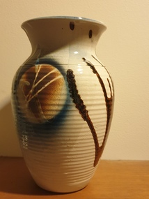
Ceramic - Artwork - Ceramics, Pottery Vase by Mark Reid
Mark REID Mark Reid began working with clay in the early 1980s, working for a time at Kairi Pottery in North Queensland. In 1985, he and his wife Robyn set up the Torvil Pottery at Buninyong, Victoria. In 1991, they relocated to a 10 acre property in nearby Magpie and set up the Ballarat Clayfire Gallery with a working studio, gallery and residence. In 2005, the Clayfire Gallery was located to Daylesford. Reid signs his work with an incised 'Mark Reid' or 'MR'. Photograph of a hand thrown ceramic vase. australian landscape pottery, gilbert buchanan, graham wood, landscape, redbyrne pottery, ceramics, shepparton, torvil pottery, ballarat clayfire gallery -
 Ballarat Heritage Services
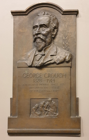
Photograph, Clare Gervasoni, Memorial Plaque to George Crouch, 07/2022
R.A. Crouch established the George Crouch Prize for contemporary art at the Ballarat Art Gallery in memory of his father. The prize an from 1927 till the 1970s.Brass plaque with a sculptural likeness of George Crouch in the Art Gallery of Ballarat. The George Crouch Prize was established by, R.A. Crouch, the son of George Crouch. memory. Thought you might want to make a correction. Obituary "A well known resident of Ballarat East in the early days. Mr George Crouch, passed away at the age of 86, at his residence, Wynnstay road, Armadale, on Wednesday. For a number of years the late Mr Crouch conducted a boot and shoe store in Bridge street, and was successful in business. He leaves a widow, two sons, amndtwo daughters, one of the sons being Lieut.-Colonel R. A. Crouch, who represented Corio in the Federal Parliament for nine years, and who is a native of Ballarat." (Ballarat Star, 9 Oct 1914 ) George Crouch 1818-1914 A Ballarat pioneer since 1852 Erected by the Council of the Gallery - 1940george crouch, art gallery of ballarat, ballarat pioneer, r.a. crouch -
 Ballarat Heritage Services
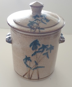
Photograph, Lidded ceramic vessel with Bamboo like design
Robert MAIR Robert (Bob) Mair (1943- ) Born New Zealand A potter who trained at the Sturt Pottery in Mittagong under Les Blakebrough and later set up a pottery at Clifton Pugh’s Dunmoochin estate at Cottles Bridge near Melbourne. He then worked with John Olsen for two years from 1969-1970, with Mair throwing and Olsen hand-decorating the pots. During the 1970s, Bob Mair worked in goldfield production pottery in Ballarat with Robert Pitman before moving to Clarendon in the Adelaide Hills in South Australia in 1982. In the late 1880s and 1990s Robert Mair is working at Sturt Pottery timeline again in the late 1980s/1990s as a visiting potter under Campbell Hegan. In the early 2000s, he and partner Janie Kerr set up a pottery at Braemar in the Southern Highlands of NSW. They then moved, first to Sutton Forest where they took up a residency at Hillview, the former summer residence of the governors of NSW, then to Wingham in the Mid North Coast region of NSW. Mair’s work may be marked with an impressed ‘RM’, an impressed tricuspid symbol or both. In Clarendon, he continued to use the tricuspud symbol with an impressed ‘Old Clarendon Pottery Adelaide’ stamp. A Ballarat mark has not been identified, but simse this lidded pot was found in Ballarat it could be a cross in a circle?Lidded ceramic container with blue bamboo like design on the outside.australian studio pottery, ceramics, bamboo -
 Whitehorse Historical Society Inc.
Photograph, Doncaster East Road, Mitcham, No.35, 2006
Coloured photo of the Winchcombe family residence on corner of Doncaster East and Glen Roads, Mitcham in 2006. Mrs Winchcombe(nee Ireland) is related to Ireland family who were early orchardists and florist in Mitcham areawinchecombe family, ireland family, doncaster east road, mitcham, no.35 -
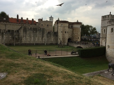 Ballarat Heritage Services
Digital photograph, Dorothy Wickham, Tower of London, 2016
The Tower of London, officially Her Majesty's Royal Palace and Fortress of the Tower of London, is a historic castle located on the north bank of the River Thames in central London. It lies within the London Borough of Tower Hamlets, separated from the eastern edge of the square mile of the City of London by the open space known as Tower Hill. It was founded towards the end of 1066 as part of the Norman Conquest of England. The White Tower, which gives the entire castle its name, was built by William the Conqueror in 1078, and was a resented symbol of oppression, inflicted upon London by the new ruling elite. The castle was used as a prison from 1100 (Ranulf Flambard) until 1952 (Kray twins),[3] although that was not its primary purpose. A grand palace early in its history, it served as a royal residence. As a whole, the Tower is a complex of several buildings set within two concentric rings of defensive walls and a moat. There were several phases of expansion, mainly under Kings Richard the Lionheart, Henry III, and Edward I in the 12th and 13th centuries. The general layout established by the late 13th century remains despite later activity on the site. The Tower of London has played a prominent role in English history. It was besieged several times, and controlling it has been important to controlling the country. The Tower has served variously as an armoury, a treasury, a menagerie, the home of the Royal Mint, a public record office, and the home of the Crown Jewels of England. From the early 14th century until the reign of Charles II, a procession would be led from the Tower to Westminster Abbey on the coronation of a monarch. In the absence of the monarch, the Constable of the Tower is in charge of the castle. This was a powerful and trusted position in the medieval period. In the late 15th century the castle was the prison of the Princes in the Tower. Under the Tudors, the Tower became used less as a royal residence, and despite attempts to refortify and repair the castle its defences lagged behind developments to deal with artillery. The peak period of the castle's use as a prison was the 16th and 17th centuries, when many figures who had fallen into disgrace, such as Elizabeth I before she became queen, Sir Walter Raleigh, and Elizabeth Throckmorton were held within its walls. This use has led to the phrase "sent to the Tower". Despite its enduring reputation as a place of torture and death, popularised by 16th-century religious propagandists and 19th-century writers, only seven people were executed within the Tower before the World Wars of the 20th century. Executions were more commonly held on the notorious Tower Hill to the north of the castle, with 112 occurring there over a 400-year period. In the latter half of the 19th century, institutions such as the Royal Mint moved out of the castle to other locations, leaving many buildings empty. Anthony Salvin and John Taylor took the opportunity to restore the Tower to what was felt to be its medieval appearance, clearing out many of the vacant post-medieval structures. In the First and Second World Wars, the Tower was again used as a prison, and witnessed the executions of 12 men for espionage. After the Second World War, damage caused during the Blitz was repaired, and the castle reopened to the public. Today the Tower of London is one of the country's most popular tourist attractions. Under the ceremonial charge of the Constable of the Tower, it is cared for by the charity Historic Royal Palaces and is protected as a World Heritage Site.(Wikipedia) A World Heritage Site is a landmark which has been officially recognized by the United Nations, specifically by UNESCO. Sites are selected on the basis of having cultural, historical, scientific or some other form of significance, and they are legally protected by international treaties. UNESCO regards these sites as being important to the collective interests of humanity. More specifically, a World Heritage Site is an already classified landmark on the earth, which by way of being unique in some respect as a geographically and historically identifiable piece is of special cultural or physical significance (such as either due to hosting an ancient ruins or some historical structure, building, city, complex, desert, forest, island, lake, monument, or mountain) and symbolizes a remarkable footprint of extreme human endeavour often coupled with some act of indisputable accomplishment of humanity which then serves as a surviving evidence of its intellectual existence on the planet. And with an ignoble intent of its practical conservation for posterity, but which otherwise could be subject to inherent risk of endangerment from human or animal trespassing, owing to unmonitored/uncontrolled/unrestricted nature of access or threat by natural or accelerated extinction owing to local administrative negligence, hence it would have been listed and demarcated by the United Nations Educational, Scientific and Cultural Organization (UNESCO) to have been identified or recognised and officially christened and internationally elevated through multilateral declaration by UNESCO as a universally protected zone. [1] The list is maintained by the international World Heritage Programme administered by the UNESCO World Heritage Committee, composed of 21 UNESCO member states which are elected by the General Assembly. (Wikipedia)The Tower of London is a UNESCO world heritage site.tower of london -
Old Colonists' Association of Ballarat Inc.
Document, Gerald Jenzen, Henry Hannington
Biography of Henry Hannington who was born in County Tyrone, Northern Ireland on 17 March 1819 and died in Ballarat at his residence in Crompton Street, Soldiers Hill on 1 January 1893 aged 73 years. Henry married Jane Crabb in the Independent Church in Melbourne in 1853. Jane died in Ballarat on the 23 January 1887,. Henry Hannington had various occupations including Shepherd, Miner, Trooper and Bricklayer. He was also listed as a Ballarat Pioneer who was resident in the District before the first Gold Licence was issued on 20 September 1851.Document on the history of early member of the Old Colonists' Association, Henry Haningtonhenry hannington, old colonists' association ballarat, ballarat old colonists' club, jane hannington -
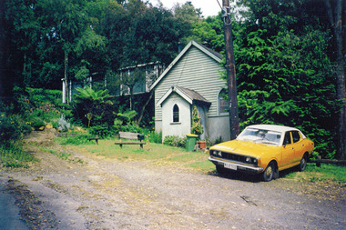 Mt Dandenong & District Historical Society Inc.
Photograph, Kalorama Methodist Church at FiveWays c1994, c1994
The church was built in 1910 or 1911 by local labour. It was closed in the early 1970's, perhaps at the time that the Uniting Church was formed. At this time, 1994, it was occupied as a residence. When Alison Cassidy purchased the building in ? to establish 'Yumbada', the 2 porch windows were purchased by the Historical Society for $70 (cost of removal).fiveways, kalorama methodist church, yumbada -
 Melbourne Legacy
Document, Inventory of Contents of "Holmbush" 1st December 1943
An inventory of domestic items purchased for Holmbush together with their cost when Holmbush was first established as a hostel for Junior Legatees.Gives an insight into the early history of one of Melbourne Legacy's residences.Foolscap sheets x 2 with black type listing the contents of Holmbush.residences, holmbush -
 Melbourne Legacy
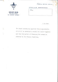
Document - Memorandum, Establishing hostels for Junior Legatees, 01/10/1942
An inter-club memorandum advising of the Board's approval to establish a hostel for Junior Legatees, later to be known as Holmbush, and ultimately as Blamey House. Holmbush was the first residential accommodation operated by Melbourne Legacy, and was established in 1942. It accommodated boys aged between 9 and 19, usually attending secondary school. In 1956, Holmbush became known as Blamey House. It was located not far from another Legacy home, Stanhope (1245 Burke Road). Residents of Holmbush and other Legacy homes were the children of deceased ex-servicemen. Sometimes residents at Legacy homes were both children of ex-servicemen and wards of state. In 1956, Blamey House, another Legacy children's home formerly in Beaumaris moved into the Holmbush property in Kew, and it was renamed Blamey House. Location 1942 - 1956? Address - Holmbush was located at 1267 Burke Road, Kew. Location: Kew Early record of the establishment of one of Melbourne Legacy's residences.Typed memo, black on white with blue letterhead outlining the agreement of the JLC board to proceed with the hostel for boys.residences, holmbush initial negotiations -
 Melbourne Legacy
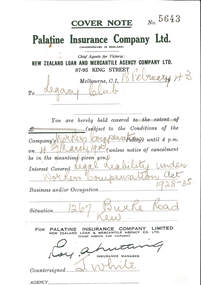
Document, Insurance Cover note, 1943
Details of Workers Compensation insurance for 1267 Burke Street, Kew (Holmbush) covering the period 18 February 1943- 18 May 1943.Part of the early administration documents for Holmbush.4 printed forms numbered 5643, 5655, 5658, 5670, green on white, details pencilled in, torn from a cover note book.residences, holmbush administration, holmbush -
 Melbourne Legacy
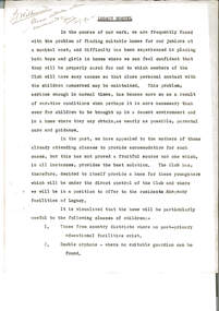
Document, Legacy Hostel
Notes on the reasons and implications for the establishment of a Melbourne Legacy residence for children, identifying the need for a safe environment for post-war childrenMore early documentation on the thinking behind the first of the Melbourne Legacy residences.Three quarto carbon copies, black on white, two holes punched for filing.'L/ Wilkinson. Please return when convenient (signature illegible) 21/12/??' Page 1 Handwritten changes Page 2 including the addition of 'It is estimated that the initial capital cost will be (Pounds) 7,000' Handwritten changes Page 3.holmbush initial negotiations, holmbush -
 Melbourne Legacy
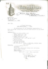
Letter, re Brick Residence 1267 Burke Road, Kew, 1942
Detailed measurements of the rooms, but the plan of the land noted as being enclosed is not included. The details had been requested in a previous telephone conversation between the parties, indicating early interest in purchasing the property which ultimately became Holmbush. Despite being from a real estate agent there is little in the way of a sales pitch.As well as indicating the extent of the rooms, it also notes that the property had a coke hot water system, which would have been typical of the 1940s, as would the elaborate letterhead.Typewritten undated letter on letterhead of Geo.M.Hume Pty Ltd., black on white, addressed to Mr. D.N. CraigSignature illegible.holmbush initial negotiations, properties, holmbush -
 Melbourne Legacy
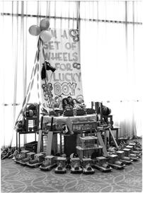
Photograph, Christmas gifts, c1966
Photo of a display of hand made toys (wooden trains, doll cribs, children's chairs, soft balls and dolls made by Victorian school children). Above them is a sign "I'm a set of wheels for a lucky boy". Appears to be gifts at a Christmas party for Junior Legatees. For many years Melbourne Legacy held Christmas parties for junior legatees - the children of deceased servicemen, often hosted by the Governor at Government House. It came from a Legacy envelope marked P7, 1966. It was an early attempt at building an archive. The contents were described in red pen as: 1 Christmas Party / Govt House 2 Toy presentation Dept of Education 3 Residence Christmas party 3 HMAS Cerberus / Operation Float / Operation Firewood (added in blue pen). (these other items will be items 00411 to 00416)A record of the items and events provided to Junior Legatees.Black and white photo of handmade toys.Stored in an envelope marked P7, listing it's contents in red pen and 1966 in pencil.christmas gifts, junior legatee outing -
 Melbourne Legacy
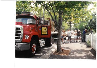
Photograph, Operation Firewood
Four photos of Operation Firewood which provided help to widows by supplying and stacking firewood for the winter. Date unknown but was probably early 1990s as the service ended in 1995. 00462.1 A truck parked outside a residence with a human chain unloading firewood. 00462.2 Close up of the human chain of workers 00462.3 Legatee Bill Strachan at the door of truck with a poster saying "Operation Firewood / All vehicles and labour donated to Legacy" 00462.4 Helpers stacking firewood in a residential yard.A record of Legacy helping widows with supplying and stacking firewood. When open fires were the main source of heating a load of firewood, and help moving it, would have been very important to the widowsColour photo x 4 of Legatees delivering firewood.00462.1 Has "8. Operation Firewood" on reverse in black penoperation firewood, widows