Showing 213 items
matching eastern view
-
 Ballarat Tramway Museum
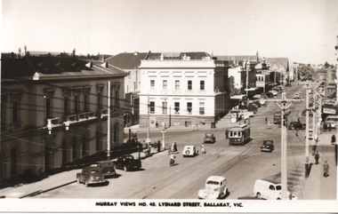
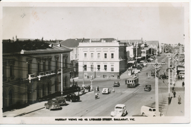
Postcard, Murray Views, "Murray Views No. 40 Lydiard Street Ballarat Vic", 1948
Photo shows No. 25 at the intersection of Sturt and Lydiard St, c 1948, and of motorcars and other users in Lydiard St North. Looking south. Murray Views No. 40 Postcard. Has Post Office and the Commonwealth Bank in view. On the rear in a note to Ken Magor, Wal Jack has written: "No. 25 to Sebastopol, turning out of Lydiard St Nth into Sturt St 1948." See item 5307 for a digital image of this view. Yields information about the appearance of Lydiard St and Sturt St intersection from the north-eastern corner and the nature of the vehicular traffic using the street, c1948.Postcard black and white, divided back, with a handwritten note on rear.See image 2 for details of the handwritten note by Wal Jack on the rear. tramways, trams, lydiard st, sturt st, tram 25 -
 Ballarat Tramway Museum
Document - Photocopy, Signalling Record Society of Victoria, "Safeworking on the Ballarat Electric Tramway System", Jul. 1988
Copy of an article by Peter Barry on the location of loops and operations of the Ballarat Tramway system. From pages 76 to 79 of the July 1988 issue of Somersault. Cover page, page 61 included. Covers running times, loop sections on Sebastopol, Lydiard St and Eastern Routes, Weekdays and Sats. and Suns., View Point, Signalling system, points where trams reversed in the section.trams, tramways, signals, crossing loop, secv, operations -
 Ballarat Tramway Museum
Postcard - Folder set, Valentine & Sons Publishing Co, "Geelong Photographic Souvenir", early 1920's
Shows views of the Geelong CBD and beach area in the 1930's including one tram photo and two other photos of trams in the street and the centre poles which were later removed. Demonstrates production of souvenirs of the era - folded postcards. The photos could also be used for individual postcards.Set of 15 black and white views of Geelong printed on a folded strip, glued within a manila colour cardboard folder, titled "Geelong Photographic Souvenir". Booklet printed with an address area with title and kookaburras and on the rear, an area where the sender could write their name. Produced by The Valentine Publishing Co. Pty Ltd Melbourne. The rear has a slit on the rear cover that allowed the folder to be secured. Pictures are: 1. Panorama of Eastern Beach Geelong 2. Eastern Beach Gardens 3. Eastern Beach 4. Ryrie St with centre poles and a tram in the distance. 5. Botanic Gardens 6. Johnstone Park 7. Gordon Technical College 8. Moorabool St. - with poles in street, single line track and tram in far distance. 9. Eastern Beach and Wharves 10 T and G Building 11 The Fountain, Eastern Beach 12 Town Hall and Post Office 13 Baron bridge - just prior to opening - roadway construction appears to be underway. 14 Malop St with tram (10?) in foreground 15 View of Johnstone Park. Made during 1930's given motor cars in the photo. trams, tramways, geelong, postcards, malop st, town hall, post office, gardens -
 Ballarat Tramway Museum
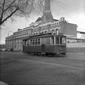
Photograph - B&W print of donated negative, John Webster, 21/08/1955 12:00:00 AM
Yields information about the appearance of Geelong No. 8 leaving the depot and the bulk or the scale of the depot and associated powerhouseBlack and white digital print from scan of a donated negative of Geelong No. 8 with the depot and powerhouse in the background. Tram has the destination of Eastern Park. Photographed by John Webster, 21/8/1955. Reference Reg Item 4195 for another view of the tram in the same location, probably from which the photo was cropped from. Photo assumed to be taken on the same date. Black and White prints made from scan of negative. Original Negative stored with Negatives. Negative scanned at hi res 2/6/2020 and image updated.On left hand side of the negatives in ink is "EI 22"tramways, trams, geelong, depot, tram 8 -
 Ballarat Tramway Museum
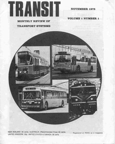
Magazine, Transit Publications Ltd and Auckland NZ, "Transit", Nov. 1975
Twenty Four page printed magazine, saddle stapled, printed on off-white paper, titled "Transit", Vol. 1 No. 1, November 1975 and subtitled 'Monthly Review of Transport Systems'. Articles feature; The Auckland Bus-rail shemozzle, Sydney Rail Progress (Eastern Suburbs line), Transit in Toronto, The new Generation of Melbourne Tramcars (Z class cars), Auckland Trolley buses (Is There a Future?), Transit topics and news, Troubled Time for Interurbans, and Transit Museums news and The New Order for Melbourne. News items note the subsidising of tram replacement buses in Ballarat and Bendigo by the SEC and that it was apparently illegal in the view of the Solicitor General (page 19) and BTPS news on operations in Wendouree Parade. Published by Transit Publications in Auckland New Zealand. Not known whether was further issues of this magazine.trams, tramways, melbourne, mmtb, ballarat, bendigo, sec, buses, sydney, toronto, museums, auckland -
 Ballarat Tramway Museum
Photograph - Digital image, Murray Views, Title Postcard Murray Views No. 40 Lydiard St Ballarat, 1948
Digital image from the Wal Jack Ballarat Album of No. 25 at the intersection of Sturt and Lydiard St, c 1948, and of motorcars and other users in Lydiard St North. Looking south. Murray Views No. 40 Postcard. Has Post Office and the Commonwealth Bank in the view. See image i2 for rear of photograph and 8974 for the actual postcard.Yields information about the appearance of Lydiard St and Sturt St intersection from the north-eastern corner and the nature of the vehicular traffic using the street, c1948.Digital image of a postcard from an album compiled by Wal Jack, loaned to the Museum.Printed on rear - Real Photograph Produced in Australia by Murray Views, Gympie Q" and places for stamp, dividing line and word "postcard"trams, tramways, lydiard st, sturt st, tram 25 -
 Ballarat Tramway Museum
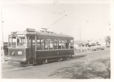
Photograph - Black & White Photograph/s, 1930's or early 1940's
Yields information about No. 28 late 1930's how the tram appeared at the time.Black and white photograph of Geelong No. 15, Birney, at the Eastern Park terminus, 1930's or 1940's? Tram has the destination of City. Photographer not known. The house behind the tram was able to be identified as 493 Ryrie St Geelong, shows up in Google Street View the verandah details. Two copies held.trams, tramways, geelong, eastern park, tram 15 -
 Otway Districts Historical Society
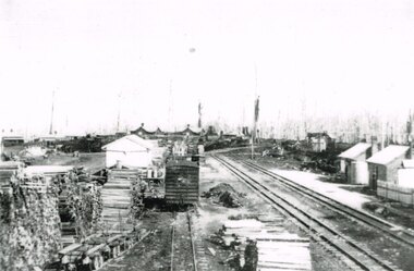
Photograph, Beech Forest Railway Station, 1910, 1910
... B/W. 177mm x 271mm. A general view from the eastern end.... A general view from the eastern end of Beech Forest station in 1910 ...By 1910 revenue from the Beech Forest railway was $15,500, working expenditure $12,000, with a net loss (including interest charges) of about $4,000. This and the following year were the lowest net losses ever experienced. Passenger journeys rose steadily, outwards goods traffic rose to a record 12,959 tons (in 1911), and inwards goods traffic was a record 3,359 tons.. The railway station possessed a goods shed, stock race and yards, engine shed, coal stage, crew cabins, a refreshment room, and a four-roomed station building, with the station staff to match. Beech Forest was the principal despatch centre at this stage for split timber. Bill Devitt laid a timber tramway to the Beech Forest railway station to cart the palings for on-shipment..B/W. 177mm x 271mm. A general view from the eastern end of Beech Forest station in 1910. Note the Goods Shed, three tracks with No.3 Road having a NU louvre van and loaded NQR wagons, timber stacks to the left, and Devitt's Tramway with unloaded trolleys at the lower left. To the right, crew cabins with shops and houses in the background.beech forest; railways; timber; tramway; -
 Ballarat Tramway Museum
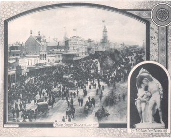
Photograph - Illustration, F W Niven & Co, "Sturt Street Ballarat on eight hours day", 1890s
The photo shows a large crowd on an 8 hours (Labour Day) gathered in the eastern end or lower end of Sturt St. The 8-hour memorial or monument is in the centre of the photograph. Has one double-deck horse tram in view along with many other horse-drawn vehicles. On the Ballarat Mechanics Institute building is an advert for "Morrey & Tyler, the Cash Drapers" at 11 Bridge St Ballarat. Also in the view are Ribble, Suttons, E Payne, the Ballarat Gas Co. building and a dentist along with other buildings. In the bottom right-hand corner is an insert photo of the statue "The Flight from Pompeii". In the bottom left hand corner is "Crisp Photo Process F W Niven & Co.Yields information about an 8 hour celebration day in the lower end of Sturt St.Illustration cut from a journaltramways, trams, sturt st, horse tram, 8 hour day monument, labour day -
 Ballarat Tramway Museum
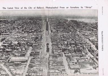
Photograph - Illustration/s, Herald & Weekly Times Ltd, Sturt St. Aerial View, 1934, Jan. 1934
Yields information about Ballarat from the eastern aspect of the city looking west in an aerial view dated 1934. Shows buildings such as the Gas Works and other buildings that no longer exist.Photographic reproduction of Ballarat looking west down Sturt St., page 6 of Magazine section of Weekly Times, Jan 20, 1934. On rear is two colour photo of Alexandria Avenue, Melbourne. Record updated and image added 21/9/2013.trams, tramways, ballarat, sturt st., aerial views -
 Buninyong & District Historical Society
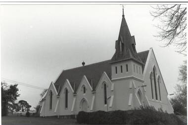
Photograph - B/W photograph, Mr. C J Brooks, Buninyong Uniting Church (formerly Presbyterian) side view, July 1993
Built in 1860 by Richard Rennie as Presbyterian ChurchRichard Rennie building, unusual designB/W photo of Uniting Church looking uphill from eastern side, showing gables and buttresses, belltower and steeple. Formerly Presbyterian Churchbuninyong, presbyterian, uniting, church, building, learmonth st -
 Kew Historical Society Inc
Photograph, J F C Farquhar, The Yarra in Hyde Park, 1891
At the beginning of the 1890s, the Kew businessman and Town Councillor, Henry Kellett, commissioned J.F.C. Farquhar to photograph scenes of Kew. These scenes included panoramas as well as pastoral scenes. The resulting set of twelve photographs was assembled in an album, Kew Where We Live, from which customers could select images for purchase.The preamble to the album describes that the photographs used the ‘argentic bromide’ process, now more commonly known as the gelatine silver process. This form of dry plate photography allowed for the negatives to be kept for weeks before processing, hence its value in landscape photography. The resulting images were considered to be finely grained and everlasting. Evidence of the success of Henry Kellett’s venture can be seen today, in that some of the photographs are held in national collections.It is believed that the Kew Historical Society’s copy of the Kellett album is unique and that the photographs in the book were the first copies taken from the original plates. It is the first and most important series of images produced about Kew. The individual images have proved essential in identifying buildings and places of heritage value in the district.Hyde Park is now a small recreation reserve bordered by Willsmere and Kilby Roads and White Avenue. In 1982, Hyde Park was cut off from the Yarra River by the construction of the Eastern Freeway. The building of the latter was to transform the natural landscape, including the Yarra, as well as Hyde Park. The construction of the Freeway makes it difficult to view the scene with the photographer’s eye. Today’s Hyde Park is located on land purchased in 1847 by John Cowell, and in 1851 Catherine Cowell, yet the scene selected by the photographer may well have been located on farmland owned by the Wills family. Farquhar’s point-of-view emphasises both the pastoral and recreational elements of the scene: the grazing cows, three boys, and in the distance two figures, seated on the bank with a parasol. By 1891, an environmental consequence of human activity, including farming, was deforestation, leading to the erosion of the south bank of the Yarra. In contrast, the land on the Alphington side of the river in 1891 included remnant bushland.The Yarra in Hyde Parkkew illustrated, kew where we live, photographic books, henry kellett, yarra river -
 Kew Historical Society Inc
Painting, Herbert J Woodhouse, River Yarra Near Dights Falls, c.1892
Herbert James Woodhouse (1854-1937) was born in Essex and arrived in Australia with his family in 1857. A painter-lithographer like his father and three of his brothers, he was a prizewinner in the South Australian Society of Arts exhibition of 1885. He also received commendations in exhibitions at the Victorian Academy of Arts and the New South Wales Arts Society. At an exhibition of his paintings at Scott’s Hotel in Collins Street in 1892, the reviewer for Table Talk noted that the ‘artist paints almost solely in the open air, and his studies are generally carried out during the trips of the Victorian Sketching Club’. One of the paintings singled out for praise was: ‘A very effective river scene at Willsmere, aptly named A Midstream Mirror, ... a picture powerful in its effective reflection of sunlight in the river.’ Herbert Woodhouse died in Geelong in June 1937, aged 82, and was buried in the Eastern Cemetery. A number of his sketchbooks are held in the collection of the State Library of Victoria.Framed oil painting on board of the River Yarra at Studley Park, Kew, by Herbert James Woodhouse (1858-1937). The artist has framed the narrow painting with trees in the foreground and a view of the Yarra River and rolling hills in the background. Verso, written by artist: "River Yarra Near Dights Falls"australian art - 19th century, herbert james woodhouse (1854-1937), yarra river - studley park -
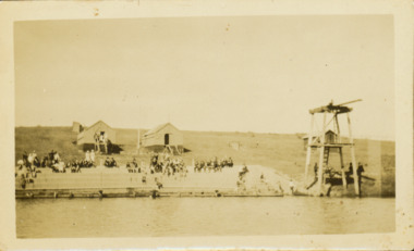 Kew Historical Society Inc
Photograph - Deep Rock Swimming Pool and Clubrooms on the Yarra, c.1925
The former Deep Rock Swimming Pool was about 500 yards [457 metres] above Dight’s Falls. It was there that the Deep Rock Swimming Club was established in 1906. This initial club was expanded in 1916 to incorporate a life-saving club. In 1918, John Wren, the president of the club offered the club £1000, and undertook to sponsor a patriotic carnival in March 1918, at which swimming champions would take part. The ‘pool’ was to achieve fame as the venue for a world record-breaking ‘swallow dive’ of 205 feet 9 inches [63 metres] by ‘Prince Wickyama’, [aka Alec Wickham], a Solomon Islander. The dive from a special platform on the west side of the Yarra was reputedly viewed by between 50,000-100,000 spectators, with funds going to the State War Council. The Herald, 25 March 1918, claimed that the wide area occupied by spectators made more precise estimates impossible. In the 1980s, the construction of the Eastern Freeway, and the consequent re-routing of the Yarra River led to the site of the Deep Rock Pool being obliterated. A small cairn and plaque on the Fairfield side of the river now marks its former site.Very rare early photograph off the Deep Rock swimming pool. The pool and its built structures are historically and socially important to the people of Collingwood, Fairfield and Kew. Small, faded, Gelatin Silver print positive photograph of the Deep Rock Swimming Pool situated on the Yarra at Collingwood and Fairfield. The famous diving tower is at the right of the photo. The built structures were constructed for the Deep Rock Swimming and Life Saving Club. People are sitting on the terraces above the river. "Bathing Club. Deep Rock on the Yarra. Studley Park Melbourne. Please credit E.J. Thomasson Collection"deep rock swimming pool, deep rock swimming club, deep rock lifesaving club, swimming -- river yarra, river yarra -
 Kew Historical Society Inc
Journal, Kewriosity : August 1989
Cricket with a difference [Kooyong Cricket Club, St Paul's School] / p1. No election for Kew / p1. Dates for August / p2. Changes to baby capsule loan scheme / p2. Council seeks comments on Area 7 Traffic Plan [Studley Park] / p2. Council to monitor Government policy on Kew Cottages Plan [deinstitutionalisation] / p3. Walpole Hill parking / p3. Fire and incinerator by-law under review / p3. Notices / p4. Local office gives tenants information [Inner Eastern Housing and Tenants' Information Service] / p4. New two-year-old session of occasional care [Kew Occasional Care Centre] / p4. Help for people with head injuries / p4. Free advice to home and business owners [Heritage Advisory Service] / p4. Images of Melbourne on local view [Ian Napier, Raya Gallery] / p5. "Sharps" Disposal Scheme planned for Kew / p5. Flowers from Friends of Bodalla / p5. Kew Community House / p6. Write about life / p6. Council supports free public libraries / p6. Senior Citizens' Week 1990 / p7. Extra school crossing supervisors for Kew / p7. Give blood for life / p7. Council may vaccinate "staff at risk" [Hepatitis B] / p7. Asbestos scheduled for removal from Council Offices / p7. Neighbourhood Watch / p8. Greenfingers change venue [Kew Garden Club] / p8. New production of The Lilac Domino [Viola Music Society] / p8. Why not croquet? [Kew Croquet Club] / p8. Footy News [Kew Football Club] / p8. Greenlink Kew / p8.Kewriosity was a local newsletter combining Kew Council and community news. It was published between November 1983 and June 1994, replacing an earlier Kewriosity [broad] Sheet (1979-84). In producing Kewriosity, Council aimed to provide a range of interesting and informative articles covering its deliberations and decision making, together with items of general interest and importance to the Kew community and information not generally available through daily media outlets.non-fictionCricket with a difference [Kooyong Cricket Club, St Paul's School] / p1. No election for Kew / p1. Dates for August / p2. Changes to baby capsule loan scheme / p2. Council seeks comments on Area 7 Traffic Plan [Studley Park] / p2. Council to monitor Government policy on Kew Cottages Plan [deinstitutionalisation] / p3. Walpole Hill parking / p3. Fire and incinerator by-law under review / p3. Notices / p4. Local office gives tenants information [Inner Eastern Housing and Tenants' Information Service] / p4. New two-year-old session of occasional care [Kew Occasional Care Centre] / p4. Help for people with head injuries / p4. Free advice to home and business owners [Heritage Advisory Service] / p4. Images of Melbourne on local view [Ian Napier, Raya Gallery] / p5. "Sharps" Disposal Scheme planned for Kew / p5. Flowers from Friends of Bodalla / p5. Kew Community House / p6. Write about life / p6. Council supports free public libraries / p6. Senior Citizens' Week 1990 / p7. Extra school crossing supervisors for Kew / p7. Give blood for life / p7. Council may vaccinate "staff at risk" [Hepatitis B] / p7. Asbestos scheduled for removal from Council Offices / p7. Neighbourhood Watch / p8. Greenfingers change venue [Kew Garden Club] / p8. New production of The Lilac Domino [Viola Music Society] / p8. Why not croquet? [Kew Croquet Club] / p8. Footy News [Kew Football Club] / p8. Greenlink Kew / p8. publications -- city of kew (vic.), kewriosity, council newsletters, community newsletters -
 Kew Historical Society Inc
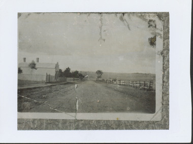
Photograph - High Street looking north to Burke Road, 1907-08
While a number of subdivisions of what was to become Kew East occurred in the 1880s, such as the 'Mount Pleasant Estate' (1888) and 'Monterey Estate' (1888), Glynn's Lot 91 remained open farmland until the Harp Estate (1912) was sold, hence the undeveloped nature of the view in 1907-8.A rare image of the open farmland in the eastern part of Kew looking towards Burke Road in 1907-8.Damaged, and very rare, black & white photograph of what was to become the suburb of East Kew, taken by a member of the Bennett family in 1907-8. The photograph is taken from the Harp of Erin Hotel showing, apart from a building on the left (no longer extant), fenced open farmland stretching into the far distance.HIGH ST LOOKING NOTRTH TO BURKE RD FROM HARP / EDWD GLYNN'S LOT 91 FROM 1851 / GIFT FROM BENNETT FAMILY 22 HARP RD EAST KEW 1980 / 1907-8harp of erin, high street -- east kew (vic), harp estate -
 Kew Historical Society Inc
Photograph - View of the Yarra River from 8 Kellett Grove, North Kew, 1948
North Kew, now divided between Kew and Kew East, bordered the Yarra River. As such, it was a region subject to flooding in the Yarra Valley. Development beyond this point (ie Kellett Grove) was limited by the City of Kew's planning regulations. Prior to urban development, the area since European settlement and the first land sales in the district in the 1840s, had been used for dairy farming. The view from the rear of 8 Kellett Grove predates the construction of the Eastern Freeway so provides a rare view of the area before it was built.Small sepia snapshot taken from the back yard of a house at 8 Kellett Grove, in what was then known as North Kew. A tower of the Kew Asylum on the top left of the horizon assist the viewer to recognise that the land to the left of the river is in Kew and Studley Park.Verso: NORTH KEW 1948 / Stamped 51019yarra river -- north kew, kellett grove -- north kew -
 Kew Historical Society Inc
Plan, Studley Park Estate, 1910
Prue Sanderson, in her groundbreaking ‘City of Kew Urban Conservation Study : Volume 2 - Development History’ (1988), summarised the periods of urban development and subdivisions of land in Kew. The periods that she identified included 1845-1880, 1880-1893, 1893-1921, 1921-1933, 1933-1943, and Post-War Development. These periods were selected as they represented periods of rapid growth or decline in urban development. An obvious starting point for Sanderson’s groupings involved population growth and the associated economic cycles. These cycles also highlighted urban expansion onto land that was predominantly rural, although in other cases it represented the decline and breakup of large estates. A number of the plans in the Kew Historical Society’s collection can also be found in other collections, such as those of the State Library of Victoria and the Boroondara Library Service. A number are however unique to the collection.The Kew Historical Society collection includes almost 100 subdivision plans pertaining to suburbs of the City of Melbourne. Most of these are of Kew, Kew East or Studley Park, although a smaller number are plans of Camberwell, Deepdene, Balwyn and Hawthorn. It is believed that the majority of the plans were gifted to the Society by persons connected with the real estate firm - J. R. Mathers and McMillan, 136 Cotham Road, Kew. The Plans in the collection are rarely in pristine form, being working plans on which the agent would write notes and record lots sold and the prices of these. The subdivision plans are historically significant examples of the growth of urban Melbourne from the beginning of the 20th Century up until the 1980s. A number of the plans are double-sided and often include a photograph on the reverse. A number of the latter are by noted photographers such as J.E. Barnes.Coloured lithograph of a subdivision plan of the Studley Park Estate, bordered by Yarra, Willsmere Road and the Outer Circle Railway line. The estate was listed in 1910 and was the subject of a planning dispute between the developer and the Town of Kew in relation to flood levels and the suitability of the land for housing. In many cases the names of streets were subsequently changed. The layout was also affected by the creation of the Eastern Freeway. A newspaper report of the day described the subdivision as a: "GOLDEN OPPORTUNITY. We are pleased to submit for PRIVATE SALE that magnificent ESTATE, situated only 4 1/2 miles from the Melbourne General Post Office, STUDLEY PARK ESTATE. KF/NV. Doubtless the CHEAPEST LAND EVER OFFERED having extensive frontages to the prettiest spot on the River Yarra and the National Park, commanding lovely river and landscape views, and acknowledged to be the finest land available so close to the city. The PRICES ARE EXTREMELY MODERATE; The TERMS ARE SIMPLY MARVELLOUS. NO DEPOSIT. NO DEPOSIT. NO DEPOSIT. Allotments and prices to suit everyone."subdivision plans - kew, studley park estate -
 Kew Historical Society Inc
Photograph - Aerial View of East Kew, c.1930
The Municipality of Kew was proclaimed in 1860. This eastern section of Kew was settled from the 1850s with all land sold in the vicinity by 1851. The original large estates were further subdivided in the second half of the 19th and in the first decades of the 20th centuries.Early aerial photograph of KewFramed aerial photograph of that part of Kew in which is located Genazzano FCJ, the Kew Reservoir, and the retail nurseries of Bennett’s and Rimington's.genazzano fcj, kew reservoir, rimington's nurseries, bennett's nursery, cotham road, mont victor road (kew) -
 Kew Historical Society Inc
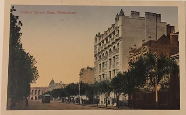
Postcard, Collins Street East, Melbourne, c.1912
Collection of thirty-nine postcards donated by Jillian Rigby which had been owned by her grandparents, George and Edith Weir, who from c.1917 lived at 84 Princess Street, Kew. The mostly 'mint' postcards were purchased in Victoria and while travelling overseas. The sole dated postcard is dated from 1929. The postcards are numbered sequentially from 2017.0058.01-39. The remainder of the collection donated by Jill Rigby which was once owned by the Weirs of Broken Hill and Kew consist of costumes, costume accessories, photographs, and documents.The postcards in the Weir collection, especially those purchased on a trip or trips to the mother country, i.e. United Kingdom, represent a representative sample of sites that were considered significant to those Australians undertaking a reverse grand tour by member of the erstwhile colonies. Those postcards which are early views of Melbourne must have been produced commercially for some decades from the early part of the 20th century.The eastern part of Collins Street. Coloured postcard of early Melbourne. Weir collection."Collins Street East, Melbourne"postcards, collins street - melbourne, george and edith weir, weir collection -
 Kew Historical Society Inc
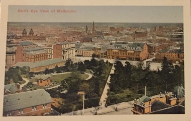
Postcard, Bird's Eye View of Melbourne, c.1911
Collection of thirty-nine postcards donated by Jillian Rigby which had been owned by her grandparents, George and Edith Weir, who from c.1917 lived at 84 Princess Street, Kew. The mostly 'mint' postcards were purchased in Victoria and while travelling overseas. The sole dated postcard is dated from 1929. The postcards are numbered sequentially from 2017.0058.01-39. The remainder of the collection donated by Jill Rigby which was once owned by the Weirs of Broken Hill and Kew consist of costumes, costume accessories, photographs, and documents.The postcards in the Weir collection, especially those purchased on a trip or trips to the mother country, i.e. United Kingdom, represent a representative sample of sites that were considered significant to those Australians undertaking a reverse grand tour by member of the erstwhile colonies. Those postcards which are early views of Melbourne must have been produced commercially for some decades from the early part of the 20th century.Bird's eye view of Melbourne looking across a park to the Princess Theatre. Coloured postcard. Weir collection."Bird's Eye View of Melbourne"postcards, george and edith weir, princess theatre, eastern hill - melbourne, weir collection -
 Kew Historical Society Inc
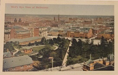
Postcard, Bird's Eye View of Melbourne, c.1911
Collection of thirty-nine postcards donated by Jillian Rigby which had been owned by her grandparents, George and Edith Weir, who from c.1917 lived at 84 Princess Street, Kew. The mostly 'mint' postcards were purchased in Victoria and while travelling overseas. The sole dated postcard is dated from 1929. The postcards are numbered sequentially from 2017.0058.01-39. The remainder of the collection donated by Jill Rigby which was once owned by the Weirs of Broken Hill and Kew consist of costumes, costume accessories, photographs, and documents.The postcards in the Weir collection, especially those purchased on a trip or trips to the mother country, i.e. United Kingdom, represent a representative sample of sites that were considered significant to those Australians undertaking a reverse grand tour by member of the erstwhile colonies. Those postcards which are early views of Melbourne must have been produced commercially for some decades from the early part of the 20th century.Bird's eye view of Melbourne looking across a park to the Princess Theatre. Coloured postcard. Weir collection."Bird's Eye View of Melbourne"postcards, george and edith weir, princess theatre, eastern hill - melbourne, weir collection -
 Kew Historical Society Inc
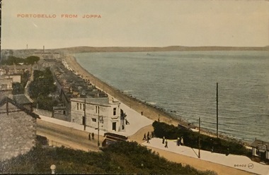
Postcard, Portabello From Joppa, c.1928
Collection of thirty-nine postcards donated by Jillian Rigby which had been owned by her grandparents, George and Edith Weir, who from c.1917 lived at 84 Princess Street, Kew. The mostly 'mint' postcards were purchased in Victoria and while travelling overseas. The sole dated postcard is dated from 1929. The postcards are numbered sequentially from 2017.0058.01-39. The remainder of the collection donated by Jill Rigby which was once owned by the Weirs of Broken Hill and Kew consist of costumes, costume accessories, photographs, and documents.The postcards in the Weir collection, especially those purchased on a trip or trips to the mother country, i.e. United Kingdom, represent a representative sample of sites that were considered significant to those Australians undertaking a reverse grand tour by member of the erstwhile colonies. Those postcards which are early views of Melbourne must have been produced commercially for some decades from the early part of the 20th century.Portabello From Joppa. Joppa is an eastern suburb of Edinburgh. The postcard was probably purchased by George and Edith Weir on a trip to England and Scotland, circa 1928. Portabello From Joppa / 8400 J.V.postcards, george and edith weir, portobello, joppa, edinburgh, postcards -- scotland (uk), weir collection -
 Freemasons Victoria - The Lodge of Australia Felix No 1
Melbourne 1839
Painting of Melbourne at the time the Lodge held it's inaugural meeting on 23 December 1839 Melbourne Viewed from the south bank of the Yarra RiverThe Lamb in inn the painting is the first meeting place of the Lodge of Australia Felix on 23 December 1839 felix, australi felix, uglv -
 Kew Historical Society Inc
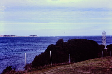
Slide - The Ripp from Fort Queenscliff, 1980
Established in 1966, the Committee of Eastern Historical Societies (CEHS) was a network of historical societies in the region east of Melbourne. Kew Historical Society was a member of CEHS in 1980 when this tour of Queenscliff was organised and held. The photograph is one of eight taken on the tour by a member of the Society and later donated to the collection.35 mm colour transparency (slide) of 'The Ripp' as viewed from Fort Queenscliff, taken on a tour by the Association of Eastern Historical Societies (AEHS) in 1980."The Ripp from Fort Queenscliff C of EHS Tour 1980"queenscliff -- victoria, committee of eastern historical societies (cehs), khs-slides, fort queenscliff, the ripp -- the heads -- port philip bay -
 Kew Historical Society Inc
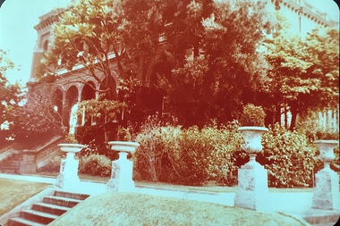
Photograph - 'Raheen', 96 Studley Park Road
Raheen was constructed as a two-storey house in the Italianate style with a four-storey tower over the entrance and single-storey extension. It was designed in an asymmetric and arcaded form, and is built of red brick with cement render. The property retains its garden layout, including an Italianate garden, outbuildings, fence and gates, and internal features including the original stairwell, library, ballroom and cast iron tower stairs. (source VHD)View of the upper and lower eastern loggias of 'Raheen' at 96 Studley Park Road, Kew from the eastern garden. The colour photo shows the pedestals and urns above the steps and the plantings in the garden c.1980. raheen -- 96 studley park road -- kew (vic.), historic houses -- studley park, mansions -- kew (vic.) -
 Kew Historical Society Inc
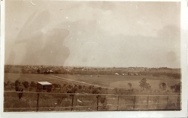
Photograph - Yarra Valley Floods: Kew East, 1916
Flooding of the Yarra Valley, including that section of the Yarra bordering Kew and Kew East in the north and west of the municipality, was a regular occurrence. Extreme flood events of the Yarra River are recorded to have occurred in 1891, 1901, 1916, 1923 and 1934. The Municipality of Kew's response to these floods was to enact planning decisions restricting residential development in flood prone areas following the floods of 1916, 1921 and 1934. While floods continued after the development of the Upper Yarra Reservoir (construction 1948-57), the regularity and extent of these inundations diminished. During the nineteenth century, the land abutting the south side of the Yarra in Kew was devoted to dairy farming. In the twentieth century, before and after the construction of the Eastern Freeway, much of this low-lying area was used as golf courses and public parks.One of a collection of photographs of flooding in the Kew section of the Yarra Valley which are in important research resource for the location and extent of flooding in the first half of the twentieth century. Flooding of the Yarra Valley at East Kew in 1916. The view is taken from the intersection of Kilby Road with what is believed to be Birdwood Street, looking across the flood waters to Ivanhoe. The extensive flooded area shown in the photograph would have included the Kew Golf Club. Verso: "Floods along Kilby Road / near Birdwood St? & Kilby Road / 1917? / 87yarra river, yarra valley, floods -- kew, kilby road -- kew (vic.), kew golf club -
 Kew Historical Society Inc
Photograph - Yarra Valley at Kew, 1918
During the nineteenth century, the land abutting the south side of the Yarra in Kew was devoted to dairy farming. In the twentieth century, before and after the construction of the Eastern Freeway, much of this low-lying area was used as golf courses and public parks.View of the farmland in the Yarra Valley at what is believed to be East Kew in 1918. Verso: "Willsmere / East Kew? / 1918"yarra river, yarra valley -
 Kew Historical Society Inc
Photograph - Yarra Valley Floods: Kew East, 1916
Flooding of the Yarra Valley, including that section of the Yarra bordering Kew and Kew East in the north and west of the municipality, was a regular occurrence. Extreme flood events of the Yarra River are recorded to have occurred in 1891, 1901, 1916, 1923 and 1934. The Municipality of Kew's response to these floods was to enact planning decisions restricting residential development in flood prone areas following the floods of 1916, 1921 and 1934. While floods continued after the development of the Upper Yarra Reservoir (construction 1948-57), the regularity and extent of these inundations diminished. During the nineteenth century, the land abutting the south side of the Yarra in Kew was devoted to dairy farming. In the twentieth century, before and after the construction of the Eastern Freeway, much of this low-lying area was used as golf courses and public parks.One of a collection of photographs of flooding in the Kew section of the Yarra Valley which are in important research resource for the location and extent of flooding in the first half of the twentieth century. Flooding of the Yarra Valley at East Kew in 1916. The view is taken from a street (maybe Birdwood Avenue) intersecting with Kilby Road looking northeast across the flood waters to Ivanhoe and Heidelberg. The extensive flooded area shown in the photograph would have included remnant dairy farms and the Kew Golf Club. Verso: "Floods / Yarra River / East Kew / Kilby Road / 1917? / 87"yarra river, yarra valley, floods -- kew, kilby road -- kew (vic.), kew golf club -
 Queen Victoria Women's Centre
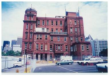
Photograph, 5 February 1996
This view of the building is no longer possible due to the QV Melbourne development in the early 2000's. Colour photograph. Whole eastern side of QVWC building before the addition for cafe and atrium was added.historic buildings, photographs