Showing 133 items matching "eltham post office"
-
 Eltham District Historical Society Inc
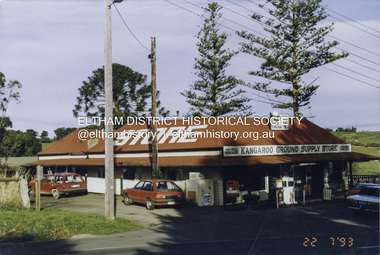
Photograph - Colour Print, Kangaroo Ground Store, 280 Eltham-Yarra Glen Rd, Kangaroo Ground, 22 July 1993
Cornelius (Con) and his wife Elizabeth ran the store and post office from about 1904. Their son Donald became involved with the store in the 1930s. A petrol bowser was added in early 1933 and a second in 1937. The Wraights ran the store till the 1940s. Elizabeth died 10 April 1952 and Cornelius May 30, 1954.Colour photo print 10 x 15 cm, originally stuck down on corflute for displaycornelius wraight, eltham-yarra glen road, general store, kangaroo ground, kangaroo ground store, kangaroo ground supply store, milk bar, post office, service station -
 Eltham District Historical Society Inc
Photograph, General Store, Research, c.1900-c.1910
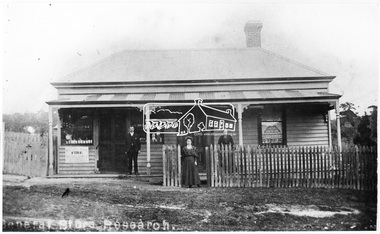
The original General Store at Research was also known as Doneys. It was located near where the present Main Road Research Shops are situated (opposite Ingrams Road). Charles Doney shown in front of the store. His wife Blanche is at the gate and his mother on the verandah. They had two boys Lance and Bill. The mother gave her daughter the opportunities and the graces. One of the children lived in a railway carriage behind the Church of England Research. A single chimney was unusual for a building like this. Store was demolished c. 1968 Cross Ref: SEPP_0501This photo forms part of a collection of photographs gathered by the Shire of Eltham for their centenary project book,"Pioneers and Painters: 100 years of the Shire of Eltham" by Alan Marshall (1971). The collection of over 500 images is held in partnership between Eltham District Historical Society and Yarra Plenty Regional Library (Eltham Library) and is now formally known as the 'The Shire of Eltham Pioneers Photograph Collection.' It is significant in being the first community sourced collection representing the places and people of the Shire's first one hundred years.Digital image, 18.5 x 29.5 cm print, 15.5 x 25.5 cm print and 120 format B&W negativesepp, shire of eltham pioneers photograph collection, research (vic.), general store, post office, doney family -
 Eltham District Historical Society Inc
Photograph - Digital Photograph, Alan King, Panton Hill Hotel, 27 March 2008
Today’s Panton Hill Hotel was built around 1920. Published: Nillumbik Now and Then / Marguerite Marshall 2008; photographs Alan King with Marguerite Marshall.; p61 Panton Hill was originally known as Kingstown, and consisted of only one hotel when the Orams Reef was discovered in 1859. Kingstown was a quartz mining centre and many old mine shafts remain in the area. Orams Reef was one of the first reefs with a rich find of gold in the area. The Hotel Francais, which had been operating in 1861, was well situated on the way to Queenstown (later St Andrews). So was Herr Hirt’s Hotel and store at Smiths Gully. The Kingstown hotel, known as the Frenchman’s and in 1864 as the Hotel de France, was run by a Monsieur Emile Hude and his wife Jeanne, and known for its good food. They hosted social events, business conventions and debates, attracting patrons from as far as Melbourne. The hotel’s name was changed to Panton Hill Hotel in 1905. In 1883 Charles Caudwell built another hotel nearby, possibly in Long Gully Road,3 which it is thought, was burnt down early last century. Today’s Panton Hill Hotel, built around 1920, is the only one of the cluster of buildings in the main road, not to date from around the turn of last century. It was severely damaged by fire in 2003, then underwent extensive alterations. It is the township’s only hotel and is an example of a modest hotel building exterior, constructed early last century. In its early days the hotel also housed the first post office, newsagency and store. Orams Reef yielded a total of £100,000, and fossikers also found alluvial gold in the creeks and gullies, but there is no record of the total value of their finds. Gold greatly increased the Panton Hill population, which peaked between 1865 and 1885. On holidays large sports meetings were held with wood chopping contests and foot races and the day would end with a ball. Miners came from various countries to seek their fortune, including many from China. The Chinese became unpopular however, and gradually left the district, although some stayed and grew and sold vegetables.5 Panton Hill was named after Joseph Panton, who in 1862 was appointed Police Magistrate for the Woods Point, Heidelberg and Yarra districts. Panton was an outstanding man, who in 1852, was Commissioner of Crown Lands and Assistant Commissioner of Goldfields at Bendigo. In 1874 he was promoted to Chief Magistrate for the Melbourne Police. Panton was also an artist, becoming president of the Victorian Arts Society in 1888, and in 1913, president of the Royal Geographical Society. Despite Panton Hill’s prosperity, it still lacked many services as poor roads made access to Melbourne difficult. A horse-drawn mail coach travelled to Melbourne until 1890, when the railway came to Heidelberg. The nearest doctor was at Yarra Glen or Heidelberg, and the Indian hawker Singh’s annual visit was very welcome. A miner’s shack opposite the school was used as a post office. Today’s general store and post office in the main road dates from early last century, and has changed considerably. While most people searched for gold, the more enterprising ones established farms to feed the diggers. Farmers grew wheat, barley and oats, and sent animal skins to the Eltham tannery, to make furs in Melbourne. As gold became scarce from around 1880, miners took up farming on 19 to 20 acre (8ha) allotments. The first settlers in Cherry Tree Road included Purcell, Smith, Owens, Hughes and Shillinglaw. By 1900 all the land had been taken up around Panton Hill and Hurstbridge. The orchards in Panton Hill and the wider district, particularly of apple and pear, were very successful, and made Panton Hill a cohesive and successful community. About 1914 the Moores built the first cool-store and refrigeration plant at their orchard in Cherry Tree Road. Many settlers planted vineyards and made high quality wine, but in 1922 the blight destroyed them.This collection of almost 130 photos about places and people within the Shire of Nillumbik, an urban and rural municipality in Melbourne's north, contributes to an understanding of the history of the Shire. Published in 2008 immediately prior to the Black Saturday bushfires of February 7, 2009, it documents sites that were impacted, and in some cases destroyed by the fires. It includes photographs taken especially for the publication, creating a unique time capsule representing the Shire in the early 21st century. It remains the most recent comprehenesive publication devoted to the Shire's history connecting local residents to the past. nillumbik now and then (marshall-king) collection, panton hill hotel -
 Eltham District Historical Society Inc
Photograph - Digital Photograph, Alan King, Nillumbik Shire Offices, Greensborough, 30 March 2008
Nillumbik Shire Council transferred to the former Diamond Valley Shire Offices in Greensborough after municipal restructuing. The offices became the official Nillumbik Shire Council Offices on 16 October 1995. The former Shire of Diamond Valley Civic Centre or Shire Office building was officially opened on 26th February 1972. Archtiects were A.K. Lines, McFarlane & Marshall and it was built by L.U. Simon Pty Ltd, The Diamond Valley Shire had been created in 1964 from part of the City of Heidelberg. On December 15, 1994 the Shire of Nillumbik was established. Under the Council amalgamations imposed by the Kennett government, the Shire of Eltham, Shire of Diamond Valley and City of Heidelberg ceased to exist with the establishment of Nillumbik Shire Council and the City of Banyule.The new Nillumbik shire surrended the west riding from Eltham to Banyule but in place gained parts of the former Diamond Valley Shire which itself had been created in 1964 from parts of the City of Heidelberg. Three unelected and non-local Commissioners were put in place by the government bringing democracy into question by many members of the local community. The Commissioners determined to abandon the former Shire of Eltham offices located in Main Road, Eltham and in turn occupy the former Shire of Diamond Valley offices located at the boundary of the new shire with Banyule, in Civic Drive, Greensborough. In July 1996 the Commissioners sold the former Eltham Shire Offices and had them bulldozed leading to many years of communiity protest over the process and future development applications. The site has remained vacant ever since. Published: Nillumbik Now and Then / Marguerite Marshall 2008; photographs Alan King with Marguerite Marshall.; p43 It was the need for roads that led to this district’s first council. In 1853 a committee was formed to improve the rough roads, some in Kangaroo Ground being almost impassable in winter.1 The committee fundraised by voluntary levies and grants to improve in particular, the main road between Kangaroo Ground and the Plenty River. From this committee arose the Eltham District Road Board, in 1856, which was the precursor to the Eltham Shire Council. The Board’s first chairman was Kangaroo Ground farmer, John Barr. Secretary was the former committee’s secretary, Andrew Ross, Kangaroo Ground’s first school teacher, and founder of the district newspaper, The Evelyn Observer.2 Most of the board’s income came from a toll-house north of the Lower Plenty Bridge, which funded such projects as a road from Kangaroo Ground to the Caledonia Diggings. In 1871 the Shire of Eltham was proclaimed, with its boundaries the same as those of the Road Board, and Councillor A Donaldson of Kangaroo Ground was the first president. Eltham was at the southern tip of the shire, which extended north to Kinglake and east beyond Yarra Glen. In 1878, part of Kinglake was added to the shire, while the area east of Watts River, near Healesville was removed. In 1912, then again in 1958, the shire was further reduced. Yarra Glen, Steels Creek, Tarrawarra, parts of Healesville and Christmas Hills, were transferred to the Shire of Healesville. In 1972 a smaller area, at Kinglake, was transferred to the Shire of Yea, leaving 277 square kilometres in the Eltham Shire. Perhaps no other Victorian municipality has had so many meeting places. Although from 1858 to 1904, the council convened at the office in the home of Secretary Charles Wingrove, the board, and later the council, also met at other more central locations.3 The board moved from the Fountain of Friendship Hotel to the Eltham Courthouse, to the Kangaroo Ground schoolhouse. It then met at the Kangaroo Ground Hotel, which some considered put it in danger of interruptions by people ‘the worse for liquor’.4 In 1885 the council met at the hall on Mr J Donaldson’s land at Kangaroo Ground. After Wingrove’s retirement, the council rented space at the Kangaroo Ground General Store and Post Office. Then, in 1917, the council bought the former office of The Evelyn Observer, after its printing works transferred to Hurstbridge. In 1934, fire destroyed the shire office, which was temporarily relocated to the Kangaroo Ground home of Shire Secretary, Mr P J McMahon. In 1941, the shire office moved to a new building (which included a public hall) in Eltham, at the corner of Arthur Street and Main Road, where the Eltham Village Shopping Centre was eventually built. Growth required new offices, which opened in 1965, on the former Shillinglaw property in Main Road.5 In 1994, as part of municipal restructuring under the Jeff Kennett Liberal Government, most of the Eltham Shire formed part of the new Shire of Nillumbik. It joined with the north section of the Diamond Valley Shire and parts of the Healesville and Whittlesea municipalities. The Diamond Valley Shire had been created in 1964, from part of the City of Heidelberg. Turbulence followed Nillumbik Shire’s formation. Under the Commissioners the council transferred to the former Diamond Valley Shire offices in Greensborough, and the Eltham council offices were demolished. In March 1997 the first five-member Nillumbik Council was elected. But, in October 1998, the government suspended the council and appointed an administrator . Early in 1999, shire residents voted to increase councillors to nine: comprising five ward councillors and four shire-wide councillors. Elections were held in March 1999. Then, before the March 2002 elections, nine new wards were created.6 In 2008 these were reduced to seven. Today [2008] the council governs a varied population of more than 60,000 people living in townships and on bush properties in the green wedge.This collection of almost 130 photos about places and people within the Shire of Nillumbik, an urban and rural municipality in Melbourne's north, contributes to an understanding of the history of the Shire. Published in 2008 immediately prior to the Black Saturday bushfires of February 7, 2009, it documents sites that were impacted, and in some cases destroyed by the fires. It includes photographs taken especially for the publication, creating a unique time capsule representing the Shire in the early 21st century. It remains the most recent comprehenesive publication devoted to the Shire's history connecting local residents to the past. nillumbik now and then (marshall-king) collection, greensborough, nillumbik shire council offices, civic drive -
 Eltham District Historical Society Inc
Photograph - Digital Photograph, Alan King, Kangaroo Ground General Store, Eltham-Yarra Glen Road, 28 December 2007
The present store was built circa 1900 to replace another which had been destroyed by fire in 1898, which had replaced a predecessor on the opposite side of the road in 1865. The store was also used as a post office until early 2000s. The general store is historically significant because it has a long association with Kangaroo Ground and has been an important centre of community life for more than 120 years - Council meetings used to be conducted in the front room of the store at a time when Kangaroo Ground rivalled Eltham as the major centre of the Shire. The general store is historically and aesthetically significant as one of a group of three well preserved public buildings in the Kangaroo Ground hamlet and as a major heritage component of Kangaroo Ground which was one of the earliest settled areas of the Shire and which has the character of an English village rather than an Australian settlement. Covered under Heritage Overlay, Nillumbik Planning Scheme. Published: Nillumbik Now and Then / Marguerite Marshall 2008; photographs Alan King with Marguerite Marshall.; p77 Today the general store is an uncommon form of trade but the one at Kangaroo Ground continues a long tradition of friendliness and service. For more than 100 years it has been a centre of community life. In the settlement’s early days a previous general store, on the same site, was the meeting place for the Eltham District Road Board, precursor to the Eltham Shire Council. For years Kangaroo Ground rivalled Eltham as the shire’s major centre. It developed very differently from the rest of the shire as its rich soil attracted prosperous Presbyterian Scots who had large agricultural properties.1 The present store was built to replace another one, which had burnt down in 1898, after replacing a predecessor on the other side of the road in 1865. The store retains its outward character and its cellar, although inside it has changed considerably. It now includes a café and offers local produce, milk bar products, grocery items, gas and other fuel. Until early this century the store was also used as a post office. Kangaroo Ground’s first postmaster was Andrew Ross, who first operated from the school opposite, then from his hotel next to the present tennis court site. The first postmaster at this store was Edward Weller, followed in 1868 by James Anderson. At that time a mail coach ran three times a week between Eltham and Woods Point through Kangaroo Ground, Yarra Flats, Healesville, Fernshaw, Marysville and Matlock. Some early postmasters were Rodger, McLaughlin, Greenway and Burns.2 Burns was the only postmaster operating from the store. The others operated from Andrew Ross’s hotel. The mail service improved in 1892 when coaches ran from Melbourne to Queenstown (now known as St Andrews) and changed horses at Kangaroo Ground twice daily. The only telegraph office in the district at that time was at the Kangaroo Ground Post Office. Telegrams to outlying areas such as Queenstown and Kinglake had to be sent by hand. A local resident in the early 1900s often rode his pony to deliver telegrams and was paid one shilling a mile porterage. The store has also contributed to the lighter side of Kangaroo Ground life. During the years that Con Wraight owned the store, between 1906 and 1946, a new piano was needed for the Kangaroo Ground Hall, so monthly dances were held to raise money. When the piano was bought, a grand ball was held in the Kangaroo Ground Hall to celebrate the occasion and supper followed at Mr Wraight’s barn, cleaned especially for the occasion. Every New Year’s Eve, a Scottish piper would set off from between the store and the schoolhouse, playing his pipes, and march to Cameron’s Pigeon Bank homestead on the Kangaroo Ground-Warrandyte Road. Between 1914 and 1922, the store was a station for the Kangaroo Ground Bush Fire Brigade’s tanker. It consisted of a wooden barrel on a cart, fitted with a hand-pump, and stood on the side of the road outside the store. Joy Ness, who belonged to an early Kangaroo Ground family, moved here in 1940 and recalled her impressions of the store at that time: ‘It was a very dark shop stained in a dark colour and on the walls just below the ceiling hung hurricane lamps, ropes, kitchen utensils and other goods for sale. ‘Goods were weighed on a brass scale with weights, on which mothers also weighed their babies, because the nearest Infant Welfare Centre was at Greensborough. The bacon was cut with a hand slicer and later a pot-bellied stove warmed the store. Farmers and other locals used to gossip around it as they collected their daily mail. In those days the butter and cheese were kept in the cellar as no ice was delivered for cooling.’This collection of almost 130 photos about places and people within the Shire of Nillumbik, an urban and rural municipality in Melbourne's north, contributes to an understanding of the history of the Shire. Published in 2008 immediately prior to the Black Saturday bushfires of February 7, 2009, it documents sites that were impacted, and in some cases destroyed by the fires. It includes photographs taken especially for the publication, creating a unique time capsule representing the Shire in the early 21st century. It remains the most recent comprehenesive publication devoted to the Shire's history connecting local residents to the past. nillumbik now and then (marshall-king) collection, eltham-yarra glen road, kangaroo ground general store -
 Eltham District Historical Society Inc
Photograph - Digital Photograph, Alan King, Shillinglaw Cottage, 6 January 2008
Covered under National Estate, National Trust of Australia (Victoria) Local Significance and Heritage Overlay, Nillumbik Planning Scheme. Published: Nillumbik Now and Then / Marguerite Marshall 2008; photographs Alan King with Marguerite Marshall.; p95 Thanks to an Australia first effort by local residents, the historic Shillinglaw Cottage still survives. The cottage at Panther Place, Eltham, once stood about 100 metres away on Main Road. But in 1963 it faced demolition to make room for the Eltham Shire Offices (since demolished). However residents rallied to save Shillinglaw Cottage and became the first in Australia to remove and reconstruct an early settler’s brick building. A fundraiser was the residents’ compilation of loved recipes into the cookery book, Flavour of Eltham. The cottage, built in the late 1870s by noted pioneer builder George Stebbing, is one of Eltham’s earliest buildings and associated with significant early settlers. It is on the National Estate and National Trust Registers. The cottage was constructed with handmade bricks in the Flemish Bond style, typical of cottages and farmhouses in Flanders, Europe. It features burnt ‘header’ bricks over the façade, which gives a chequered effect. The roof is made of slate, while the windows are 12-paned sash with relieving arches. It is not clear who were the first owners of the cottage. The National Trust claims that Stebbing built it for farmer Thomas Cochrane.1 Others say Cochrane first owned the land but Stebbing was Shillinglaw’s first owner and remained so until 1887. The Shillinglaw family then bought it and lived there for around 80 years until 1963 when they sold it to the Eltham Council.2 Farmer Thomas Cochrane bought the Shillinglaw Cottage site from land developer Josiah Holloway. The site was the largest in what Holloway called Little Eltham, of some 30 acres (12 ha), extending along the creek from Henry Street to Luck Street. In 1874 Cochrane sold the land to George Stebbing. Meanwhile in 1861, Stebbing was the owner and occupier of a house at Pitt Street, Eltham, which he had built. Evelyn Observer journalist James Rossiter rented the Pitt Street house, then in 1881 Phillip Shillinglaw occupied it. Stebbing constructed several buildings of note in the area, including the Uniting Church at John Street, the building beside it – a former bank – and St Margaret’s Church of England in Pitt Street. Stebbing was also an Eltham Shire Councillor from 1871 to 1873 and a trustee and treasurer of the Eltham Wesleyan Church.3 In the 1870s he is recorded as the owner of up to five houses. Earlier he had been described as a bricklayer and later became a farmer. In 1882 Stebbing returned to the Pitt Street house and Shillinglaw occupied the new house in Main Road, which he owned from 1887. Shillinglaw was a prolific poet and preached at the Eltham Primitive Methodist Church, where he also served as Sunday School superintendent and led the Young People’s Society Christian Endeavour. The Shillinglaws saw many changes in their property’s boundaries – the major one occurring at the turn of the century when land for the railway and Eltham station was acquired from their holding. The northern part of the remaining land was then used for some of the first commercial developments in what was to become the Eltham Shopping Centre. Later still, the land immediately north of the cottage was bought by the Eltham War Memorial Trust for the War Memorial Buildings and the fire station. The Trust’s land eventually passed to the council. The council bought the remaining two acres (0.8 ha) with the house, and with the exception of the commercial development between the fire station and the post office, all of the former Shillinglaw land is owned by the council or government instrumentalities.4 Since the late 20th century, the cottage has had varied uses, such as a handcrafts store and as a restaurant.This collection of almost 130 photos about places and people within the Shire of Nillumbik, an urban and rural municipality in Melbourne's north, contributes to an understanding of the history of the Shire. Published in 2008 immediately prior to the Black Saturday bushfires of February 7, 2009, it documents sites that were impacted, and in some cases destroyed by the fires. It includes photographs taken especially for the publication, creating a unique time capsule representing the Shire in the early 21st century. It remains the most recent comprehenesive publication devoted to the Shire's history connecting local residents to the past. nillumbik now and then (marshall-king) collection, shillinglaw cottage -
 Eltham District Historical Society Inc
Photograph - Digital Photograph, Marguerite Marshall, Jelbart home, 93 Arthur Street, Eltham, 11 November 2006
Situated at the top of the hill in Arthur Street, the former Jelbart residence and barn were part of a major change that transformed Eltham's character in the late 1960s. Built from the mid 1940s through mid 1950s when Eltham was a rural community, the Jelbrat residence and barn are all that remain of a family property of some 250 acres (100 ha). With growing population pressures, in the late 1960s, owners Ron and Yvonne Jelbart decided to subdivide their property creating the Woodridge Estate in the early 1970s, a major factor towards the transformation of Eltham to the suburb it is today. The Jelbarts had moved to Eltham in the early 1940s when they purchased a poultry farm in New Street, now Lavendar Park Road. (The local Black Friday bushire of January 13, 1939 had started at C.A. (Clarrie) Hurst’s Eltham Poultry Farm and Hatchery in New Street.) Jelbart was primarily a businessman importing office machinery but desired farm beef and dairy cattle so the couple purchased the virgin bushland at what was then at the end of a dirt road, Arthur Street. With post war shortages of most building materials, they followed the example of the Eltham Artists' Colony (later called Montsalvat) and built thier home from mud-bricks and recyclked materials. The barn was first to be completed in 1945 which they made their home whilst building the main residence. It took eight years to complete the two buildings. Both the main residence and the barn are now separate homes, and along with the remaining property being sub-divided further in 1998 are now part of the Kinloch Gardens Estate at 93 Arthur Street. Covered under Heritage Overlay, Nillumbik Planning Scheme. Published: Nillumbik Now and Then / Marguerite Marshall 2008; photographs Alan King with Marguerite Marshall.; p139 Standing on a hilltop at Arthur Street, Eltham, the Jelbart residence and former barn were part of a major change that transformed Eltham’s character in the late 1960s. Built from the late 1940s to the mid 1950s when Eltham was a rural community, they are all that remain of what was once a family property of around 250 acres (100 ha). As population pressure increased in the late 1960s, owners Ron and Yvonne Jelbart, decided to subdivide their property. The break-up of this property into the Woodridge Estate in the early 1970s, was a major factor towards transforming Eltham into the suburb it is today.1 Although standing only a few minutes from Eltham’s busy hub and hundreds of houses in Woodridge, scarcely any urban sound disturbs the peace. Views from the two buildings are almost exclusively of trees and extend to Mt. Dandenong to the south-east, the Great Divide to the north, and Melbourne city to the south-west. The Jelbarts had lived in Eltham since the early 1940s when they bought a poultry farm in New Street, now Lavender Park Road. Although Jelbart was primarily a businessman importing office machinery, he was keen to farm dairy and beef cattle, so the couple bought rough bushland at what was then the end of Arthur Street. But a shortage of building materials following World War Two hampered their plans to build their new home, so they followed the example of the Eltham Artists’ Colony (later called Montsalvat) and used mud-bricks and recycled materials.2 With great determination the family and friends constructed their house. Massive timber frames and huge quantities of mud-bricks were made on site. The barn was built first in 1945, and two years later, while camping inside, the Jelbarts started building their house. It took eight years to construct the two buildings, even with the help of professional tradesmen. The buildings, with timber frames infilled with mud-brick and plastered, are reminiscent of the English Tudor style. The Jelbarts are of Cornish stock. Much of the timber framework came from demolished bridges or warehouses, and recycled slate was used for roofs and floors. Quality second-hand materials were readily available in the late 1940s and 1950s when there was much demolition in Melbourne and little respect for heritage. A former 19th century Toorak mansion Woorigoleen provided the magnificent stone fireplace, the timber panelling and the parquetry floor in the living room. The large stone gateposts at the entry of the property came from Melbourne University. Almost no mechanical equipment was used to build the 55 square house and the 25 square barn. Massive timber frames were erected using block and tackle pulleys and timbers were shaped, sawn and drilled by hand. Son and architect Ian, with his family, have lived in and extensively renovated both buildings since the early 1970s. Ian transformed the steep ridge of the property into a plateau, where the main house Kinloch stands, surrounded by terraces and lawns. The grounds retain many native plants, including massive yellow boxes – some nudging 80 years. Ian attached 70 metres of pergolas draped with wisteria, roses and grape vines, to three sides of the house. The beautiful garden is featured in the book Through the Rose Arbour by Rosemary Houseman. The two-storey barn – now a house – retains traces of its original use. The cow-shed with milking and feed-rooms, and the machinery-shed remain. The house, separated on the ground floor by a breeze-way, soars two storeys and includes a mezzanine. These are connected by spiral staircases, to timber-beamed and plaster-lined high-pitched ceilings. The house also descends to a wine cellar. Curiously the roof is of corrugated iron on the south and slate on the north, to save costs. Small-paned windows and three French doors open onto the front lawn, which extends to Jelbart Court.This collection of almost 130 photos about places and people within the Shire of Nillumbik, an urban and rural municipality in Melbourne's north, contributes to an understanding of the history of the Shire. Published in 2008 immediately prior to the Black Saturday bushfires of February 7, 2009, it documents sites that were impacted, and in some cases destroyed by the fires. It includes photographs taken especially for the publication, creating a unique time capsule representing the Shire in the early 21st century. It remains the most recent comprehenesive publication devoted to the Shire's history connecting local residents to the past. nillumbik now and then (marshall-king) collection, eltham, arthur street, jelbart barn, jelbart home, kinloch gardens -
 Eltham District Historical Society Inc
Photograph - Digital Photograph, Alan King, St Matthew's Church and Hall, Panton Hill, 27 March 2008
St. Matthew's Church has historic significance as the town's church and physical and social focus for the community. The standard design buildings are good examples and important streetscape elements. The war memorial cross is the area's monument to the 20th century wars and its modest scale in comparison with the granite Eltham and towered Kangaroo Ground memorials illustrates the lack of affluence in the town and surrounding area. The grouping of church, school, store and post office is typical of country villages throughout Victoria. The Radiata Pine plantings are significant as an intact line of shelterbelt planting typical of the early 20th century. (Bick Study 1992) Covered under Heritage Overlay, Nillumbik Planning Scheme. Published: Nillumbik Now and Then / Marguerite Marshall 2008; photographs Alan King with Marguerite Marshall.; p63 Panton Hill’s first church services were held in a simple building made of paling timber, opposite the Hotel de France. The building was also used for Sunday School, a school and a hall.1 The St Matthew’s Church and hall at the corner of Church Road and Kangaroo Ground-St Andrews Road, were built in the early 20th century in the standard rectangular style of the times. The intact belt of Radiata Pines was common at that time. The war memorial concrete cross is the area’s monument for the 20th century wars. It is much more modest than those in Eltham, and particularly in Kangaroo Ground, demonstrating those townships’ comparative affluence.2 Early settler J Hughes, who donated the land to the Church of England, was the first to be married at St Matthews when he married Rachel Coutie. In later life he became a minister of religion.3 One much-liked preacher was George Hollow, who with his sister playing the harmonium, conducted church services at Panton Hill, St Andrews and Christmas Hills, for many years.This collection of almost 130 photos about places and people within the Shire of Nillumbik, an urban and rural municipality in Melbourne's north, contributes to an understanding of the history of the Shire. Published in 2008 immediately prior to the Black Saturday bushfires of February 7, 2009, it documents sites that were impacted, and in some cases destroyed by the fires. It includes photographs taken especially for the publication, creating a unique time capsule representing the Shire in the early 21st century. It remains the most recent comprehenesive publication devoted to the Shire's history connecting local residents to the past. nillumbik now and then (marshall-king) collection, panton hill, st matthew's church, panton hill war memorial -
 Eltham District Historical Society Inc
Document - Folder, Scarce, Henry and others
Henry Scarce of Suffolk worked on John Dickson's farm "Gulf Station", Yarra Flats, then in 1849 settled at Kangaroo Ground. Contents Letter J Scarce to Eltham Historical Society, 19 April 1976 seeking information on Henry Scarce. Letter Eltham Historical Society to J Scarce, 10 June 1976, proving information on Henry Scarce. Photocopy of photograph: Smith family, Panton Hill, 1894, identifying Florry, later Mrs Scarce. Handwritten notes by Joy Ness, undated: Extracts from "Victoria and its Metropolis 1888" and "Victorian Post Office Directory" and other notes regarding Henry Scarce. Handwritten notes, undated, no author: Notes on Scarce family. Letter from Norma Lawler, undated (earlier page/s not present). Request for information on woman (presumably named in earlier page/s) who came from Kangaroo Ground to Eltham in the 1900s. Newspaper clippings, A4 photocopies, etchenry scarce, kangaroo ground, florry scarce (nee smith), vera jackson, henry john (jack) scarce, john jardine scarce, thomas scarce, keith scarce, kangaroo ground school, john dickson, gulf station, john bell, "violet bank" kangaroo ground, "the hall" kangaroo ground, "kiata" kangaroo ground, "woodlands" kangaroo ground, "pigeon bank" kangaroo ground, e h cameron, mrs p d coysh, mrs v wippill, bob meadows, jack jarrold, john jardine, thomas jardine, "garden hill" kangaroo ground, edward haughton, "coorie bank" kangaroo ground, margaret charlton -
 Eltham District Historical Society Inc
Journal - Newsletter, Newsletter, No. 270 June 2023
Contents: • Recording Our History by Jim Connor • Our Next Meeting - 2.00pm Saturday 10th June 2023 • Heritage Walk - Saturday 1st July 2023 - Research Valley South Side • Eltham Horse and Pony Club by Tony Brocksopp • What’s Happening by Liz Pidgeon • Frank’s New Shoes by Jim Connor • Many Hands Make Flags Fly!! By Terry Beaton • A Catalogue of Killings by Richard Pinn • Early Land Sale Documents • Annual General Meeting - Saturday 15th April 2023 • Eltham Cemetery Stories by Liz Pidgeon o Anne Hunniford, (Burgoyne) nee Hamilton, 1813-1899, Pioneer o Anne Jane Hunniford 1855-1927, Post Mistress The Shire of Eltham Historical Society was formed in October 1967. The first newsletter of the Society was issued May 1978 and has been published continuously ever since on a bi-monthly basis. With the cessation of the Shire of Eltham in late 1994, the Society's name was revised to Eltham District Historical Society and this name first appeared with issue No. 103, July 1995. The collection of the Society's newsletters provides a valuable resource on the history of the Society's activities, office bearers and committee members, guest speakers and subjects of historical interest pertinent to the former Shire of Eltham and the Eltham District.A4 newsletter distributed to members (Digital and A4 photocopy)newsletter, eltham district historical society -
 Eltham District Historical Society Inc
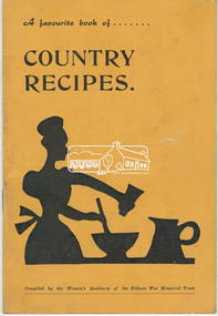
Book, Eltham War Memorial Trust, A favourite book of country recipes / compiled by the Women's Auxiliary of the Eltham War Memorial Trust, 1958
46 page book produced by the women of the Shire of Eltham as a fundraising project for the construction of the WW2 Eltham War Memorial. Contents: I. Fish, II. Meat, III. Puddings and desserts, IV. Bread and scones, V. Cakes and biscuits, VI. Jams, marmalades and chutneys, VII. Salads, dressings and sauces, VIII. Drinks. 47 p. : ill., b&w., ; 19 cm. a. & s. davis pty ltd, a. boyd-graham, a. lyon, a. mezner, a. uglow, a.m. lynes, b. clark, b. rothwell, b. thomas, b.j. brinkkotter, b.m. gresford, b.w. morrison, betty p. metcalfe, briar hill timber & trading, c. may, c. pelling, c. smith, cold comfort farm, commercial bank of australia, cook-book, cooking, d. garratt, d. richards, d. warner, d.g. wills, draffin bros pty ltd, e. egan, e. hoppner, e.i. rains, e.s. rothwell, eltham home supplies, eltham hotel, eltham motor garage, eltham real estate & business agency, eltham war memorial trust, f.j. burgoyne, g.b. gresford, gas and fuel corporation of victoria, george lovitt & co pty ltd, guest's biscuits, h.w. downing, heidelberg district bakery, i. putnam, j. & j. burgoyne, j. kimber, j.m. attiwill, jack burgoyne, kraft cheddar, l. carter, lyon bros garage, m. banks, m. battye, m. black, m. erswell, m. foletta, m. johnson, m. roletta, m.h. bucknell, m.j. loosli, millett's foodland, n.h. baxter estate agent, n.h. baxter, new bridge building supplies, m. banks, m. battye, m. black, m. erswell, m. foletta, m. johnson, m. roletta, m.h. bucknell, m.j. loosli, millett's foodland, n.h. baxter estate agent, n.h. baxter, new bridge building supplies, o. holland, o.a. brown, p. moore, p. pease, p. peel, p. reece, presswell's eltham east auto service, r.j. scully, rains, recipes, research meat supply, research post office and general store, s. littlehales, stanley s addison, t. sawyer, t.e. & e.m. moran, v. addison, v. hughes, valley furniture, women's auxiliary, cookery, fundraising -
 Eltham District Historical Society Inc
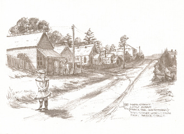
Print, Don Brown, Maria Street, Little Eltham (from a pre 1900 photograph) - Main Street looking south from Bridge Street, 1980
Greeting card from Neville Emerson and Staff with sketch commissioned by Neville Emerson Real Estate. Church is Methodist, built 1880. Eltham Hotel is the square building on the left hand side of the road at apex of Maria St, built 1852. Post Office is on the left side of road above the child's head. Note only telegraph lines on top of poles: phone still being "invented". Print of ink sketch, reproduced as greeting cardart, emerson real estate, bridge street, little eltham, main road, maria street, don brown -
 Eltham District Historical Society Inc
Film - Video (VHS), Dynavision Video Production, 1994 Eltham Festival, 11 Nov 1994
20th Eltham Community Festival and last under the auspices of the Shire of Eltham. The Grand Parade focussing on the theme "Echoes of Eltham - Celebrating the visions of Eltrham from the past and into the future" was headed by Jock Read on his horse Lofty who had been filmed in an Anzac Day Parade on an earlier horse which had featured in the television show Matlock. The parade travelled north along Main Street to just past the Post Office then back south to Panther Place. Parade participants included 1st Eltham Brownies, 1st Eltham Venturers, 2nd Eltham Sea Scouts, 2nd Eltham Venturers, 3rd Eltham Brownies, Australian Democrats, Briar Hill Primary School, Circus Chaos, Country Fire Authority, Diamond Valley People for Disarmament, Diamond Valley Railway, Eltham Community Health Centre, Eltham District Horse and Pony Club, Eltham East Primary School, Eltham Fire Brigade, Eltham Junior Football Club (Panthers), Eltham Little Theatre, Eltham North Primary School, Eltham Playhouse Co-op, Eltham Pre-school, Eltham Roller Skating Club, Eltham South Pre-School Centre, Eltham Steam and Stationary Engine Society, Greenhills Neighbourhood House, Heidelberg Municipal Band, Hurstbridge Learning Co-op, Jocklebeary Farm, Kangaroo Ground Primary School, Learning Co-op Primary School, Lower Plenty Primary School, Main Road, Montmorency Gardening Club, Montmorency South Primary School, North Warrandyte Fire Brigade, Plenty Valley 88.6 FM, Research Pre-school, Research Primary School, Ron Sampson, Salvation Army Band (Briar Hill), Sherbourne Primary School, Shire of Eltham, State Emergency Service (Eltham) and Woodridge Pre-school. The parade commentary was provided by Plenty Valley FM 88.6 with guest commentator, Shire President Cr. John Graves. Following the parade is video footage from a helicopter of Alistair Knox Park, displays along Main Road and activities in Alistair Knox Park and the Rugby oval along with stationary engines, helicopter joyrides, Eltham People's Choir, music entertainment. Scenes also from the Diamond Valley Railway at Eltham Lower Park and finishing with the fireworks display. At the end of the video is a promotional video for Dynavision Video Production, a local video production company that produced the video and Diamond Photos (Kodak Express). One of the highlights of the festival was a tree planting ceremony in Alistair Knox Park to celebrate 123 years of the Shire of Eltham led by Shire President Cr. John Graves and representatives of the Wurrundjeri, traditional land owners of the area.VHS Video cassette (poor quality) Converted to MP4 file format 45:01, 535MB DVD copy of VHS cassette (better quality)1st eltham brownies, 1st eltham venturers, 2nd eltham sea scouts, 2nd eltham venturers, 3rd eltham brownies, 1994, aerial photographs, alistair knox park, arthur street, australian democrats, briar hill primary school, circus chaos, country fire authority, diamond valley people for disarmament, diamond valley railway, eltham community health centre, eltham district horse and pony club, eltham east primary school, eltham festival, eltham fire brigade, eltham junior football club (panthers), eltham little theatre, eltham lower park, eltham north primary school, eltham people's choir, eltham playhouse co-op, eltham pre-school, eltham roller skating club, eltham south pre-school centre, eltham steam and stationary engine society, grand parade, greenhills neighbourhood house, heidelberg municipal band, hurstbridge learning co-op, jock read, jocklebeary farm, john graves, kangaroo ground primary school, learning co-op primary school, lofty (horse), lower plenty primary school, main road, matlock police (tv show), montmorency gardening club, montmorency south primary school, nicholaus lauder estate, north warrandyte fire brigade, plenty valley 88.6 fm, research pre-school, research primary school, ron sampson, salvation army band (briar hill), sherbourne primary school, shire of eltham, state emergency service (eltham), video recording, woodridge pre-school