Showing 205 items
matching engineering - other
-
 Rutherglen Historical Society
Photograph - Image, c1895
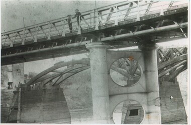
The 'new' John Foord Bridge was built between1887 and 1895, and replaced an 1862 timber bridge constructed by a company involving John Foord. A plaque, placed on the bridge by the The Institution of Engineers, Australia names it as a "NATIONAL ENGINEERING LANDMARK". Black and white photograph of two bridges. One appearing below the span of the other. The bridge in the foreground has just been opened and the old wooden bridge, being demolished, is shown in the background.Written on back of photo: "John Foord Bridge, Wahgunyah. New & old"john foord bridge, bridges, murray river, wahgunyah, corowa -
 Ballarat Heritage Services
Photograph - Photograph - Colour, Clare Gervasoni, Nimon's Bridge, 1999, 04/10/1999
Nimons Bridge was built in 1890, as part of the then Ballarat-Linton railway. The bridge is 17 spans with tall timber piers of four driven piles each, with triple sets of diagonal cross-bracing and walers and a single row of longitudinal horizontal bracing between piers. The spans are of a uniform twenty feet (6.1 metres), originally supported by four 21-inch x 9-inch (535 mm x 230 mm) Kauri timber beams per span, following the standard V.R. design of the period. When the superstructure was rebuilt after the 1953 fire, the timber beams were replaced with two 24-inch (610mm) deep rolled-steel-joists on each span. These are marked 'Lancashire Steel Co., Scotland' and are believed to have been second-hand. The deck of transverse-timber planks is 103.6 metres in length. Overall the bridge has an impressive appearance with its exceptionally tall triple-cross-braced piers creating a 'three-tiered' effect, with the deck 19.2 metres above the Woady Yaloak River. The Ballarat-Skipton line closed in 1985. Nimons Bridge has been recently restored, as part of the Ballarat-Skipton Rail Trail. How is it significant? Nimons Bridge is significant for technical, historic and aesthetic reasons at a State level. Why is it significant? Nimons Bridge is technically significant as Victoria's fourth-tallest timber trestle bridge when built, and as the third-tallest surviving example. It is also the second-largest composite bridge combining traditional timber piers with RSJ spans and a timber deck and falls within a select group of fewer than ten timber railway bridges with horizontal longitudinal bracing between the piers and three sets of double cross-bracing on its tallest piers, creating a visually striking 'three tiered' effect that enhances its viaduct form. Nimons Bridge is historically significant as having served initially the mining community at Linton, then the Western District agricultural area and in later years a kaolin quarry at Pittong. Nimons Bridge is historically significant as a representative of the 'light' branch line methodology that stimulated the explosion of railway construction in Victoria during the 1880s, and provides an interesting contrast with the more solid and vastly more expensive railway viaducts built in similar terrain on Victorian main lines, at Moorabool and Taradale, in the late 1850s. Approached by a deep cutting and high embankment at either end, the bridge represents a very cost-effective late 19th century engineering solution to the characteristic physiography of western Victoria with flat basalt plains intersected by deep wide valleys occasionally subject to severe flooding. Nimons Bridge is aesthetically significant for its visually impressive viaduct form, crossing a deep and steep-sided valley that is part of a rich cultural landscape. Within close proximity of the bridge are mullock dumps, tailings, shaft sites and other relics of the deep-lead alluvial mining era. The bridge is the most visually spectacular timber-trestle rail bridge in Western Victoria and is among the most spectacular timber-trestle rail bridges surviving anywhere in Victoria. It is part of the Ballarat-Skipton Rail Trail. Classified by the National Trust :02/10/2000 (http://vhd.heritagecouncil.vic.gov.au/places/67986)Colour photograph of a log bridge known as Nimon's Bridge.ballarat-linton, nimons bridge, nimon's bridge, log bridge, viaduct, timber-trestle rail bridge -
 Dandenong/Cranbourne RSL Sub Branch
Badge - RAN Bridging Train Collar Badge, Circa 1914/15
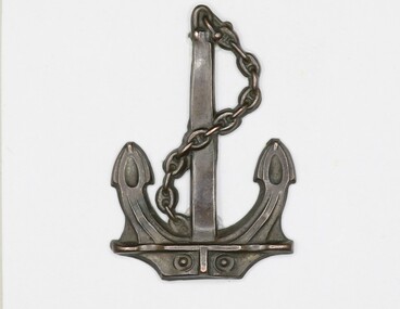
The 1st Royal Australian Naval Bridging Train (1st RANBT) was formed in Melbourne on 28 February 1915 and was intended to be a horse drawn engineering unit attached to the Royal Naval Division (RND), then serving as infantry on the Western Front. The term ‘train’, in its title, was a direct reference to the horse drawn wagons that would, in theory, form and move ‘in train’ to carry the unit’s heavy lumber, building materials and engineering equipment to the front. The unit was manned by members of the Royal Australian Naval Reserve for whom there were no available billets in seagoing RAN ships. Many of the sailors serving in the 1st RANBT were rated ‘drivers’, and again, this refers to wagon drivers as opposed to motor vehicle drivers. Other seamen were rated as ‘artificers’ or ‘sappers’, the latter being a military term traditionally used to describe army engineers. Appointed in command of the 1st RANBT was Lieutenant Commander Leighton Seymour Bracegirdle, RAN. Bracegirdle was ideally suited to command the unit, having seen active service with the NSW Naval Brigade during the Boxer Rebellion in China as well as serving as a military officer in the South African Irregular Horse during the Boer War in 1901. He had also recently returned from German New Guinea where he had served as a staff officer in the joint Australian Naval and Military Expeditionary Force (ANMEF) responsible for the capture of the German colonies in the Pacific in September 1914. Three hundred naval reservists, including 50 men who had recently served in New Guinea, were selected for the 1st RANBT and they began their training in horsemanship, engineering and pontoon bridging at the Domain in Melbourne. By late May 1915 a decision was made to send the unit to Britain to complete its training and then to join the RND on the Western Front. The plan, however, never eventuated. The complaints about the non-combatant work being done by the men had been raised in Federal Parliament and following consultation with the senior Australian officer in the Middle East, Lieutenant General Sir Harry Chauvel, a recommendation was made that the unit be disbanded and its men used as reinforcements for the AIF. Consequently, Lieutenant Commander Bracegirdle was advised that his unit was to be dispersed; its men transferring to the AIF or being returned to Australia for discharge. On 27 March 1917 the 1st RANBT was officially disbanded.Oxidised brass anchor shaped collar badge.ww1, world war 1, first world war, ranbt, ran bridging train, royal australian navy bridging train, collar badge -
 Ballarat Heritage Services
Digital photograph, Dorothy Wickham, Trajan's Columns, Victoria & Albert Museum, London, 2016, 09/2016
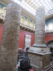
These original columns are marble, made in 113AD. They come from Rome, Italy and are held in the Cast Courts at the Victoria & Albert Museum, London. The collection of casts at the museum is one of the most important in the world. Their original purpose was educational when it was not easy to trail and see original works. they thus provided an opportunity for students to study. The Cast Courts opened in 1873 and allowed the display of large monuments. These galleries are currently divided by nationality. Photograph of a cast of Trajan's Column at the Victoria & Albert Museum, London. The column has been displayed in two parts. he massive cast is a tremendous feat of both engineering and casting. Displayed in the Architectural Courts from the time of their opening in 1873, it provided the opportunity for students (and others not able to travel to Rome) to see this iconic monument of the classical world. The cast of the column is made up of sections of plaster reliefs that are attached to an inner chimney built of brick. Each section was individually numbered so that the column could easily be assembled like a giant jigsaw puzzle. (http://www.vam.ac.uk/content/articles/t/trajans-column/)trajan's column, roman forum, plaster casts -
 Unions Ballarat
Photograph: Ballarat Civic Hall Dinner - Elly Mewson, Bob Hawke (Prime Minister) and Norm Borchers, 8 June 1989
Photograph: Elly Mewson, Bob Hawke (Prime Minister) and Norm Borchers at Ballarat Civic Hall Dinner. Others in photograph have not been identified. Bob Hawke was Prime Minister of Australia and the Leader of the Labor Party from 1983 to 1991. Norm Borchers passed away in 2008. Borchers was a Club President of the Sebastopol Lions Club (1975-76). He worked for the railways as an engineering employee and was long-term trade unionist (Amalgamated Engineering Union and the Australian Railways Union) and ALP member; he lived and worked in the Ballarat area. Norm was active in workplace disputes during the ALP split in 1955. He was a long time supporter of Ballarat Trades Hall. Photograph.btlc, ballarat trades hall, ballarat trades and labour council, mewson, elly, hawke, bob, prime minister, borchers, norm, politicians, ballarat civic hall -
 Unions Ballarat
Book - E.J. Rowe (Ted Rowe) - collected documents, Sydney Morning Herald, 1949-2019
Ted Rowe was a delegate of the Amalgamated Engineering Union and was Ballarat Trades Hall President for two years - 1941-1942. He was also an activist in the Communist Party of Australia. The collection includes a memoir from one of Rowe's descendants. Original documents not held. Items are print-outs and photocopies. 1. Sydney Morning Herald (NSW), 18/5/1949, Communists Seek Control of Powerful A.E.U. 2. Tribune (NSW), 25/8/48, Party Life 3. Tribune (NSW), 5/10/60, Passing of "Ted" Rowe 4. Tribune (NSW), 12/10/60, FUNERAL ORATION FOR E.J. (TED) ROWE: "Outstanding son of working class, Party" 5. Tribune (NSW), 12/10/1960, TED ROWE'S FUNERAL 6. Tribune (NSW), 19/10/60, Ted Rowe: Last Respects 7. Olive, Doug (Communist Party of Australia, Queensland), n.d., "The Queensland Railway Strike" (excerpts) 8. Moloney, Gary (descendent/grandson), "Memories of E.J. Rowe"Trade union history and of particular significance to Ballarat Trades and Labour Council and the Amalgamated Engineering Union.Copies of press clippings and other documents.btlc, ballarat trades and labour council, ballarat trades hall, rowe, e.j. - ted, aeu, railway strike, queensland, communist party australia, obituaries - death notices - funeral notices, industrial action, memoir, amalgamated engineering union -
Hume City Civic Collection
Machine - Dictaphone
This dicta phone was used by the Shire of Bulla Engineering Department for the recording of letters or other information that would then be typed up by an office person.This is a cream coloured electric dicta phone in a small brown case with plastic handle and two locks. It also has a hand held microphone, a grey metal foot pedal, an electrical cord and ear phones included in the case. This item is quite heavy.Stenoretteshire of bulla, office equipment -
 Ballarat Tramway Museum
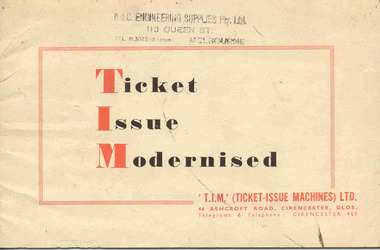
Manual, TIM - Ticket Issue Machines (Australia) and Bentleigh, "Ticket Issue Modernised", c1950
Sixteen page book printed on off white paper, with card cover, side stapled and titled "Ticket Issue Modernised". Details the TIM system, benefits, uses, sample tickets, components, examples of use, TIM "Major" for long distance routes, use for admission tickets, packing slips, cash receipts etc along with sample tickets, costs, cancellation punch, canceler and servicing. On the rear has a list of British Transport undertakings using the system and other users. On front cover has the stamp of "MdC Engineering Supplies Pty Ltd of 113 Queen St Melbourne". Printed on front cover is TIM UK company details. Full scan of document added as a pdf file 5/6/2019.On front cover has the stamp of "MdC Engineering Supplies Pty Ltd of 113 Queen St Melbourne"trams, tramways, tickets, ticket machines, buses -
 Ballarat Tramway Museum
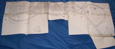
Document - Photocopy, City of Ballaarat, Plan of Gardens, 1920s?
Photocopy - No Number, no date, other than BTM Number 228, No title – plan showing roads and trees in the Gardens area, early drawings, many roads on the east side of Lake Wendouree not built . Photocopy onto heat sensitive paper – 9 separate sheets joined with tape. An additional sheet added at the St. Aidans end showing roads – in pencil. Probably compiled for the BTPS by Bill Kingsley for planning purposes.Has “228” in biro on rear of sheet, and “Scale 100 foot to 1 inch” on front of sheet.trams, tramways, signals, forest city signals, equipment, electrical engineering -
 Bendigo Historical Society Inc.
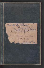
Book - JOSEPH BRADY COLLECTION: NOTEBOOK, BENDIGO WATER WORKS - CRUSOE RESERVOIR AND OTHER CONTRACTS 1870 TO 1874
Dark green covered book with gold edging front and back and seven horizontal lines on the spine. On front cover: buff sticker, with Bendigo Water Works, Crusoe Reservoir and others, contracts 1870 - 1874 written in cursive script. Later writing 'from Mrs. H. Strickland, Bungoona, Currie, King Island'. Written inside is: Presented to Bendigo Historical Society by Mrs A Strickland, Bungoona, Currie, King Island. Also the Historical Society Stamp. The next page has three newspaper cuttings. The first is 'The Victorian Waterworks'. It has costings for contracts for water supply, amounts which will supply water from the Coliban to the Castlemaine and Sandhurst districts, and if the Government should purchase the Bendigo Waterworks, and to construct the Upper Coliban reservoir, additional expenditure may be required. (from Daily Telegraph - 1868). The second is some information on The Yan Yean Aqueduct. The third is a letter to the Editor of the Argus from Joseph Brady, dated August 2, 1870, in reference to repairing the leak in the outlet tunnel of the Malmsbury Reservoir. He says the repair of the tunnel was not essential and is unnecessary and 2nd. If the bank was cut through and restored, for years the bank would not be safe, as the earth used in the restoration would require time to subside and unite with the old work. He hopes the embankment would be allowed to stand intact.civil engineering, water supply, coliban, bendigo water works - crusoe reservoir and other contracts 1870 to 1874, mrs a strictland, royal historical society of victoria bendigo branch, coliban scheme, upper coliban reservoir, daily telegraph 1868, yan yean aqueduct, age, argus 2/8/1870, malmsbury reservoir, joseph brady, charles cook, fishburn morton & kennedy, bernard ward & co, the fulton foundry co ltd, james mcewan & co, laylands foundry co, melbourne sewers & water supply, c w gore, crusoe office, john mcilwraith, edward chandler, ia-s miller & co, robison br & co, guthrie/white hills pottery, peter mcpherson, slater & co, john danks, mclean br & rigg, william beebe, t i connelly, i horwoods -
 Queenscliffe Maritime Museum
Equipment - Hand operated divers air pump
Standard diving dress (also known as hard-hat or copper hat equipment, or heavy gear) is a type of diving suit that was formerly used for all relatively deep underwater work that required more than breath-hold duration, which included marine salvage, civil engineering, pearl shell diving and other commercial diving work, and similar naval diving applications. Standard diving dress has largely been superseded by lighter and more comfortable equipment. Standard diving dress consists of a diving helmet made from copper and brass or bronze, an air hose from a surface-supplied manually operated PUMP or low pressure breathing air compressor, a waterproofed canvas suit, a diving knife, and weights to counteract buoyancy, generally on the chest, back and shoes. Later models were equipped with a diver's telephone for voice communications with the surface.Hand operated divers air pump for one or two diversdiving, air pump -
 Ballarat Tramway Museum
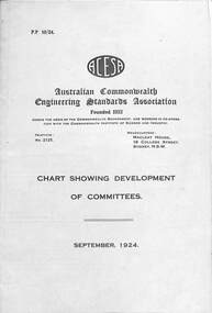
Pamphlet, ACESA - Chart of Committees and Bulletin No. 1, 1924
Provides information on the work of the Australian Commonwealth Engineering Standards Association that was founded in 1922 and later became the Standards Australia who celebrated 100 years in Oct. 2022. Work at the time was on railway, tramway, electrical and other items such as cement. Note the entry for Trolley Wheel Grooves.Demonstrates the work of the Australian standards body in the formation of tramway and electrical standards.Set of two pamhlets or documents published by the Australian Commonwealth Engineering Standards Association 1 - fold out sheet - 6 sections, titled ACESA - Chart showing development committees - Sept. 1924 2 - four page - ACESA - Bulletin No. 1 31-10-1924acesa, standards, tramways, electrical engineering, rails, power engineering, tramway rails -
 Ballarat Tramway Museum
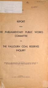
Document - Report, Parliament of Victoria, "The Yallourn coal reserves", May 1971
Report looked into the future of the Yallourn Township. Has a brief history of the location, the SEC power generation and its relationship the history of Vitoria. Lists the parliamentary inquiry board members, the witnesses, a table of the community organisations based at Yallourn township, coal reserves and costs. The Parliamentary Committee recommended that the SEC proposal be followed, that is close the township and mine the coal reserves that were under the township. Dated May 1971.Yallourn and other mines provided the brown coal for Ballarat B Power station and power Ballarat's tramways.Foolscap report - 6 sheets + 3 folded sheets, stapled on the left hand side and bound with black tape.Has the markings of the State Transport Library.yallourn, secv, brown coal, power supply, power engineering -
 Ballarat Tramway Museum
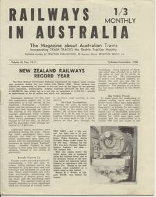
Magazine, Traction Publications, Railways In Australia - Oct/Nov 1950, Nov. 1950
24 page magazine, publisher by Traction publication recording current event in Australia & New Zealand railways & tramways - with photos, advertisements, see list for contents. Railways in Australia The Magazine about Australian Trains, incorporating TRAM TRACKS, the Electric Traction Monthly Contents (Summary) Articles New Zealand Railways - Record Year - pl, 2 and 3 Diesel operation of South line is SAR plan - p2 Comrails plan big improvements - p3 New north line soon for NSWR? - p3 About Locomotives - QGR Garratt's, VR N class, R class, NSW 58, TGR diesels - p4 and 5 Holiday by Rail - C.Einsiedel - Vic and NSW Comparisons are Odious - An American View - PCC tram for MMTB - p9 More Fare increase - Sydney, Melbourne and elsewhere - p10 Operation 'Strike' - Melbourne Trams Handle Crowds - by KSK - p 1 2 and 13 (VR trains on strike) - very interesting. - has map of ~B including authorised lines. High Voltage ~ Electric Railway news - NSW, VR, Gippsland - p 14 Model Railways in Australia - p 1 8 and 19 The Mayfield Lines ( large garden 0 gauge model railway, by L.A. Clark, includes plan - p20 and 2 I.) Photographs NSW steam loco 5801 - pl TGR diesel railcars built by Comeng - p3 NSW 38's - p4 MMTB PCC tram 980 and interior view - p9 Photo of St Louis Car Co. B3 bogie used under PCC car - p10 Perth Trolley Bus - No. 41 - p 1 3 Advertisements McGills Newsagency - p2 John C. Beckett - photographer - p6 Meadmores model engineering Co. - p6 and p 14 WAGR institute magazine - p6 Wattle Park - p7 Australian Model Hobbies - SA - p 1 5 Traction Publications - p 1 5 The Main Hobby Depot - Melbourne - p 1 5 Railway Destination Rolls, LA Clark - pl 5 Model repairs - R.Pearson - p19 Hearn's Hobbies- p21 The Hobby Shop p21 Herbert Small - p21 Australia Railway Models - p22 Scale Model Railway Equipment - p23 Bames Tennis Centre - p23 Traction publications listings and books etc. - p24 - and where to purchase magazine. Amalgamated Blind and Tent Co. - p24 Other List of office bearers and general information for ARLHS Obituary for Maj Gen. A.C.Fewtrell Chief Civil Engineer for NSWGR Tramway news - Sydney King St. Closure, Wanganui system closure, Latrobe St. Melbourne, Melbourne VR trams, SEC trams purchasing maximum traction trams, Launceston, Hobart, Kalgoorlie - p I 1, Brisbane, Perth and Adelaide - p I 5 Drawing of Adelaide H class trams - p 1 9 Club noticeboard, and Question box - on Outer circle Railway. Wad 25.11.95 Record images added 20/8/2013. trams, tramways, australian railways, new zealand railways, model railways, model tramways -
 Kew Historical Society Inc
Plan, Melbourne & Metropolitan Board of Works : Borough of Kew : Detail Plan No.1582, 1904
The Melbourne and Metropolitan Board of Works (MMBW) plans were produced from the 1890s to the 1950s. They were crucial to the design and development of Melbourne's sewerage and drainage system. The plans, at a scale of 40 feet to 1 inch (1:480), provide a detailed historical record of Melbourne streetscapes and environmental features. Each plan covers one or two street blocks (roughly six streets), showing details of buildings, including garden layouts and ownership boundaries, and features such as laneways, drains, bridges, parks, municipal boundaries and other prominent landmarks as they existed at the time each plan was produced. (Source: State Library of Victoria)This plan forms part of a large group of MMBW plans and maps that was donated to the Society by the Mr Poulter, City Engineer of the City of Kew in 1989. Within this collection, thirty-five hand-coloured plans, backed with linen, are of statewide significance as they include annotations that provide details of construction materials used in buildings in the first decade of the 20th century as well as additional information about land ownership and usage. The copies in the Public Record Office Victoria and the State Library of Victoria are monochrome versions which do not denote building materials so that the maps in this collection are invaluable and unique tools for researchers and heritage consultants. A number of the plans are not held in the collection of the State Library of Victoria so they have the additional attribute of rarity.Original survey plan, issued by the MMBW to a contractor with responsibility for constructing sewers in the area identified on the plan within the Borough of Kew. The plan was at some stage hand-coloured, possibly by the contractor, but more likely by officers working in the Engineering Department of the Borough and later Town, then City of Kew. The hand-coloured sections of buildings on the plan were used to denote masonry or brick constructions (pink), weatherboard constructions (yellow), and public buildings (grey). Public buildings, coloured grey on the Plan 1582 include the police station and post office, churches and schools. The earliest church school, Common School No.356 was located at the rear of the Congregational Church in Peel Street. It was constructed in 1859. The first buildings of Kew Primary School No.1075 on the other side of Peel Street were constructed in 1871. The school in 1903 only occupied a small fraction of its current site. In 1903, where the rear playground is now located, were two weatherboard and one brick villa. Trinity Grammar School was founded in 1902 and opened in the Parish Hall at the rear of Holy Trinity Anglican Church. It was not to move to its current site until 1906. The outline of the building housing the Kew Fire Brigade in the centre of the north side of Walton Street is shown but not named on the plan. Further down Pakington Street stood the two-storey Italianate mansion ‘Overton’. The home of Stanford Chapman, it was to be featured in the Imperial Institute series of bromide photographs of Victoria, Vol. 1: Homes and scenery. It was later to become a boarding house before it was later demolished.melbourne and metropolitan board of works, detail plans, maps - borough of kew, mmbw 1582, cartography -
 Kew Historical Society Inc
Plan, Melbourne & Metropolitan Board of Works : Borough of Kew : Detail Plan No.1301, 1910
The Melbourne and Metropolitan Board of Works (MMBW) plans were produced from the 1890s to the 1950s. They were crucial to the design and development of Melbourne's sewerage and drainage system. The plans, at a scale of 40 feet to 1 inch (1:480), provide a detailed historical record of Melbourne streetscapes and environmental features. Each plan covers one or two street blocks (roughly six streets), showing details of buildings, including garden layouts and ownership boundaries, and features such as laneways, drains, bridges, parks, municipal boundaries and other prominent landmarks as they existed at the time each plan was produced. (Source: State Library of Victoria)This plan forms part of a large group of MMBW plans and maps that was donated to the Society by the Mr Poulter, City Engineer of the City of Kew in 1989. Within this collection, thirty-five hand-coloured plans, backed with linen, are of statewide significance as they include annotations that provide details of construction materials used in buildings in the first decade of the 20th century as well as additional information about land ownership and usage. The copies in the Public Record Office Victoria and the State Library of Victoria are monochrome versions which do not denote building materials so that the maps in this collection are invaluable and unique tools for researchers and heritage consultants. A number of the plans are not held in the collection of the State Library of Victoria so they have the additional attribute of rarity.Original survey plan, issued by the MMBW to a contractor with responsibility for constructing sewers in the area identified on the plan within the Borough of Kew. The plan was at some stage hand-coloured, possibly by the contractor, but more likely by officers working in the Engineering Department of the Borough and later Town, then City of Kew. The hand-coloured sections of buildings on the plan were used to denote masonry or brick constructions (pink), weatherboard constructions (yellow), and public buildings (grey). Throughout its history, the land in what is known today as Studley Ward of the City of Boroondara has been subject to continuing subdivision. This is evident in Plan 1301, where later hands have modified the original map to include streets created subsequent to the printing of the plan in 1904. Other annotations such as the ‘Reserved for Road Purposes’ beside the Yarra never eventuated. The plan continued to be modified to at least 1953, when a later hand noted that a particular site was ‘Property site P. McIntyre house’ in Swinton Avenue. Two significant houses in the area are outlined on the plan: ‘Swinton’ on the corner of the streets then named Effey and Maud Streets (now Swinton Avenue) and ‘Fairhaven’ [unnamed] in Stevenson Street. The gardens of the two David Syme owned mansions of ‘Blythswood’ and ‘Rockingham’, stretching down to the River Yarra, are also represented.melbourne and metropolitan board of works, detail plans, mmbw 1301, cartography -
 Kew Historical Society Inc
Plan, Melbourne & Metropolitan Board of Works : Borough of Kew : Detail Plan No.1350, 1910
The Melbourne and Metropolitan Board of Works (MMBW) plans were produced from the 1890s to the 1950s. They were crucial to the design and development of Melbourne's sewerage and drainage system. The plans, at a scale of 40 feet to 1 inch (1:480), provide a detailed historical record of Melbourne streetscapes and environmental features. Each plan covers one or two street blocks (roughly six streets), showing details of buildings, including garden layouts and ownership boundaries, and features such as laneways, drains, bridges, parks, municipal boundaries and other prominent landmarks as they existed at the time each plan was produced. (Source: State Library of Victoria). This plan forms part of a large group of MMBW plans and maps that was donated to the Society by the Mr Poulter, City Engineer of the City of Kew in 1989. Within this collection, thirty-five hand-coloured plans, backed with linen, are of statewide significance as they include annotations that provide details of construction materials used in buildings in the first decade of the 20th century as well as additional information about land ownership and usage. The copies in the Public Record Office Victoria and the State Library of Victoria are monochrome versions which do not denote building materials so that the maps in this collection are invaluable and unique tools for researchers and heritage consultants. A number of the plans are not held in the collection of the State Library of Victoria so they have the additional attribute of rarity.Original survey plan, issued by the MMBW to a contractor with responsibility for constructing sewers in the area identified on the plan within the Borough of Kew. The plan was at some stage hand-coloured, possibly by the contractor, but more likely by officers working in the Engineering Department of the Borough and later Town, then City of Kew. The hand-coloured sections of buildings on the plan were used to denote masonry or brick constructions (pink), weatherboard constructions (yellow), and public buildings (grey). MMBW Plan No. 1350 depicts the western end of Studley Park on the north side of the Studley Park Road. ‘Raheen’, then the home of Sir Henry Wrixon is named, the plan identifying those parts of the house that were built of brick and timber. The two houses between Raheen and the River Yarra are also shown. Other parts of the plan show neighbouring streets: Yarra Street, Studley Park Avenue, Studley Street and Fenwick Street. Each, apart from Fenwick Street was subsequently renamed. At the corner of Fenwick and Stawell Streets, the home of Joseph Butterworth Coombs, later called ‘Hope Mansell’, is represented but unnamed.melbourne and metropolitan board of works, detail plans, mmbw 1350, cartography -
 Kew Historical Society Inc
Plan, Melbourne & Metropolitan Board of Works : Borough of Kew : Detail Plan No.1565, 1905
The Melbourne and Metropolitan Board of Works (MMBW) plans were produced from the 1890s to the 1950s. They were crucial to the design and development of Melbourne's sewerage and drainage system. The plans, at a scale of 40 feet to 1 inch (1:480), provide a detailed historical record of Melbourne streetscapes and environmental features. Each plan covers one or two street blocks (roughly six streets), showing details of buildings, including garden layouts and ownership boundaries, and features such as laneways, drains, bridges, parks, municipal boundaries and other prominent landmarks as they existed at the time each plan was produced. (Source: State Library of Victoria). This plan forms part of a large group of MMBW plans and maps that was donated to the Society by the Mr Poulter, City Engineer of the City of Kew in 1989. Within this collection, thirty-five hand-coloured plans, backed with linen, are of statewide significance as they include annotations that provide details of construction materials used in buildings in the first decade of the 20th century as well as additional information about land ownership and usage. The copies in the Public Record Office Victoria and the State Library of Victoria are monochrome versions which do not denote building materials so that the maps in this collection are invaluable and unique tools for researchers and heritage consultants. A number of the plans are not held in the collection of the State Library of Victoria so they have the additional attribute of rarity.Original survey plan, issued by the MMBW to a contractor with responsibility for constructing sewers in the area identified on the plan within the Borough of Kew. The plan was at some stage hand-coloured, possibly by the contractor, but more likely by officers working in the Engineering Department of the Borough and later Town, then City of Kew. The hand-coloured sections of buildings on the plan were used to denote masonry or brick constructions (pink), weatherboard constructions (yellow), and public buildings (grey). MMBW Plan No.1565 is an example of a plan where a number of streets have been created since the area was surveyed, or in other cases renamed. The plan shows those streets that were bordered by Ross Street, Mount Street, Sackville Street and Burke Road. Since 1905, Mawson Street has been created and Mont Albert Road renamed as Dean Street. Named houses on the plan include ‘Tyrol’, ‘Glengorse’, ‘Theodore Villa’, ‘Arncliffe’, ‘Ballynira’ and ‘Hazeldene’. The plan also shows a Wesleyan Church in Sackville Street. In 1883, the Church’s Sunday School celebrated its silver anniversary.melbourne and metropolitan board of works, detail plans, mmbw 1565, cartography -
 Kew Historical Society Inc
Plan, Melbourne & Metropolitan Board of Works : Borough of Kew : Detail Plan No.1568, 1905
The Melbourne and Metropolitan Board of Works (MMBW) plans were produced from the 1890s to the 1950s. They were crucial to the design and development of Melbourne's sewerage and drainage system. The plans, at a scale of 40 feet to 1 inch (1:480), provide a detailed historical record of Melbourne streetscapes and environmental features. Each plan covers one or two street blocks (roughly six streets), showing details of buildings, including garden layouts and ownership boundaries, and features such as laneways, drains, bridges, parks, municipal boundaries and other prominent landmarks as they existed at the time each plan was produced. (Source: State Library of Victoria)This plan forms part of a large group of MMBW plans and maps that was donated to the Society by the Mr Poulter, City Engineer of the City of Kew in 1989. Within this collection, thirty-five hand-coloured plans, backed with linen, are of statewide significance as they include annotations that provide details of construction materials used in buildings in the first decade of the 20th century as well as additional information about land ownership and usage. The copies in the Public Record Office Victoria and the State Library of Victoria are monochrome versions which do not denote building materials so that the maps in this collection are invaluable and unique tools for researchers and heritage consultants. A number of the plans are not held in the collection of the State Library of Victoria so they have the additional attribute of rarity.Original survey plan, issued by the MMBW to a contractor with responsibility for constructing sewers in the area identified on the plan within the Borough of Kew. The plan was at some stage hand-coloured, possibly by the contractor, but more likely by officers working in the Engineering Department of the Borough and later Town, then City of Kew. The hand-coloured sections of buildings on the plan were used to denote masonry or brick constructions (pink), weatherboard constructions (yellow), and public buildings (grey). Plan No.1568 covers the area bounded by Cotham Road, John Street, Sackville Street, and Edward Street. Alfred Street and Rowland Street are in shown in the middle of the plan. The two most notable buildings shown are ‘St Helliers’, the home of the Dumaresq family, and St Hilary’s Church and school. While the colours used to indicate St Hilary’s are grey as in other civic/public buildings, the first St Hilary’s Anglican Church was at this stage constructed in weatherboard. At the left of the plan, facing Sackville Street is a house named ‘Glencara’. The 1988 ‘Kew Conservation Study’ recorded that “The first documentary evidence of this house comes from Rate Books which record that in 1893 a Mrs Treadway was the owner of this building with an N.A.V. of £81? At that date the occupier of the house was Charles B. Kelly, a clerk, while by 1910 Kelly had become the owner of the property described in that year ‘as a six-roomed stone, brick and wood house with stables and outbuildings’”. Contrary to this description, the 1905 plan indicates that the house was entirely constructed of masonry.melbourne and metropolitan board of works, detail plans, mmbw 1568 -
 Kew Historical Society Inc
Plan, Melbourne & Metropolitan Board of Works : Borough of Kew : Detail Plan No.1571, 1904
The Melbourne and Metropolitan Board of Works (MMBW) plans were produced from the 1890s to the 1950s. They were crucial to the design and development of Melbourne's sewerage and drainage system. The plans, at a scale of 40 feet to 1 inch (1:480), provide a detailed historical record of Melbourne streetscapes and environmental features. Each plan covers one or two street blocks (roughly six streets), showing details of buildings, including garden layouts and ownership boundaries, and features such as laneways, drains, bridges, parks, municipal boundaries and other prominent landmarks as they existed at the time each plan was produced. (Source: State Library of Victoria)This plan forms part of a large group of MMBW plans and maps that was donated to the Society by the Mr Poulter, City Engineer of the City of Kew in 1989. Within this collection, thirty-five hand-coloured plans, backed with linen, are of statewide significance as they include annotations that provide details of construction materials used in buildings in the first decade of the 20th century as well as additional information about land ownership and usage. The copies in the Public Record Office Victoria and the State Library of Victoria are monochrome versions which do not denote building materials so that the maps in this collection are invaluable and unique tools for researchers and heritage consultants. A number of the plans are not held in the collection of the State Library of Victoria so they have the additional attribute of rarity.Original survey plan, issued by the MMBW to a contractor with responsibility for constructing sewers in the area identified on the plan within the Borough of Kew. The plan was at some stage hand-coloured, possibly by the contractor, but more likely by officers working in the Engineering Department of the Borough and later Town, then City of Kew. The hand-coloured sections of buildings on the plan were used to denote masonry or brick constructions (pink), weatherboard constructions (yellow), and public buildings (grey). This plan is the other half of Plan No.1571 representing the constructions to the west of Wellington Street before and in 1903/4. This plan represents the built environment in Edgevale Road, Wellington Street, Atkins Street, Annadale Street, Mortimer Street, and Cotham Road. Whereas there are smaller allotments and more modest housing stock facing Edgevale Road, larger blocks and more substantial houses are represented facing Cotham Road.melbourne and metropolitan board of works, detail plans, mmbw 1571, cartography -
 Kew Historical Society Inc
Plan, Melbourne & Metropolitan Board of Works : Borough of Kew : Detail Plan No.1572, 1905
The Melbourne and Metropolitan Board of Works (MMBW) plans were produced from the 1890s to the 1950s. They were crucial to the design and development of Melbourne's sewerage and drainage system. The plans, at a scale of 40 feet to 1 inch (1:480), provide a detailed historical record of Melbourne streetscapes and environmental features. Each plan covers one or two street blocks (roughly six streets), showing details of buildings, including garden layouts and ownership boundaries, and features such as laneways, drains, bridges, parks, municipal boundaries and other prominent landmarks as they existed at the time each plan was produced. (Source: State Library of Victoria)This plan forms part of a large group of MMBW plans and maps that was donated to the Society by the Mr Poulter, City Engineer of the City of Kew in 1989. Within this collection, thirty-five hand-coloured plans, backed with linen, are of statewide significance as they include annotations that provide details of construction materials used in buildings in the first decade of the 20th century as well as additional information about land ownership and usage. The copies in the Public Record Office Victoria and the State Library of Victoria are monochrome versions which do not denote building materials so that the maps in this collection are invaluable and unique tools for researchers and heritage consultants. A number of the plans are not held in the collection of the State Library of Victoria so they have the additional attribute of rarity.Original survey plan, issued by the MMBW to a contractor with responsibility for constructing sewers in the area identified on the plan within the Borough of Kew. The plan was at some stage hand-coloured, possibly by the contractor, but more likely by officers working in the Engineering Department of the Borough and later Town, then City of Kew. The hand-coloured sections of buildings on the plan were used to denote masonry or brick constructions (pink), weatherboard constructions (yellow), and public buildings (grey). Plan No. 1572 represents the built environment bordered by Barkers Road, Wrixon Street, Edgevale Road and Fitzwilliam Street. Other streets identified on the plan include Stansell Street. Plan 1572 shows that by 1903-05, there was only patchy development in this area of Kew, mainly on Edgevale Road and Fitzwilliam Street. Only two named houses are identified: the quaintly named ‘Tweed Cottage’, and ‘Mendip’. The earliest reference to Treed Cottage in Australian newspapers is to the death of Walter Thompson, aged 74 who was a resident there in 1885. His youngest daughter was to die there in 1908. Mendip to the north of Tweed Cottage was owned by Henry Thompson; he was to die in 1901; his wife in 1932. At this period of time, Malin Street and Clivedon Court did not extend to Barkers Road.melbourne and metropolitan board of works, detail plans, mmbw 1572, cartography -
 Kew Historical Society Inc
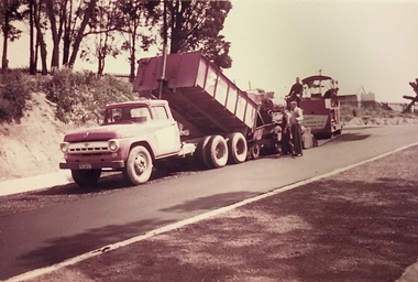
Photograph, Public Works, Road Construction, 1950s
An original photograph donated to the Kew Historical Society by the City's Engineering Department before the amalgamation of Kew into the City of Boroondara in 1994.While not all of the photographs are of Studley Park, Kew or East Kew, each photo provides a fine snapshot of the work of local government engineering departments of the period. They reveal they types of labour conducted, the techniques used and the equipment and machinery in the possession of the local government authority.Public works. Roadmaking machinery in the 1950s using a tip truck and other equipment. Inscription on reverse: "Road making. Date?" city of kew (engineering department), road construction maintenance -
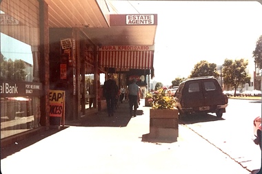
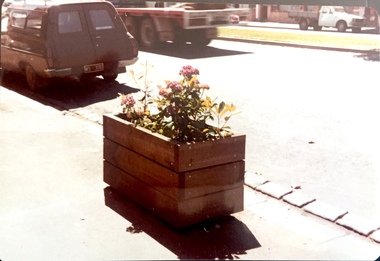
 Kew Historical Society Inc
Photograph - Street Beautification: Port Melbourne
The City Engineer's Department within the former City of Kew, was responsible for public works, including street beautification. This photograph was held in the archives of the Department and was subsequently gifted to the Kew Historical Society. Like other examples originally held by the Department, photographs of road works, street beautification, engineering works were often sourced from other municipalities, or countries, to use as references for engineering works and design in Kew.Colour photographic positive (faded) of street beautification in Port Melbourne, used as a model by the Engineer's Department of the City of Kew for how civic spaces, including shopping centre precincts, could be improved. street beautification, city of kew -- engineers department, public works -- kew (vic.), port melbourne -
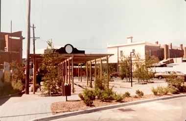
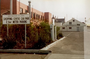 Kew Historical Society Inc
Photograph - Carpark: South Melbourne
The City Engineer's Department within the former City of Kew, was responsible for public works, including street beautification. This photograph was held in the archives of the Department and was subsequently gifted to the Kew Historical Society. Like other examples originally held by the Department, photographs of road works, street beautification, engineering works were often sourced from other municipalities, or countries, to use as references for engineering works and design in Kew.Colour photographic positive (faded) of public parking in South Melbourne, perhaps used as a model by the Engineer's Department of the City of Kew for how civic spaces, including shopping centre precincts, could be improved. city of kew -- engineers department, public works -- kew (vic.), south melbourne, carparks, signs -
Maldon Vintage Machinery Museum Inc
Air Compressor
Horizontal single cylinder air compressor. V belt driven with 11 belts. V belt on one end of crankshaft and flywheel on the other end. Painted pale green.Logo cast in relief in several places signifying - "Thompsons Castlemaine Engineering Propriety". Stenciled on cylinder "M75".machinery - compressors; metalcraft. -
Maldon Vintage Machinery Museum Inc
Booklets, 1) Angle Compressors. .2) Compound Blast-furnace Blowing Engine
Two paper covered booklets printed in black and white with photographs of specified items. .2) On back cover has b & w photos of other products made by Thompsons & Co. (Castlemaine) Pty. Ltd..documents, pamphlets, engineering, machinery, compressors -
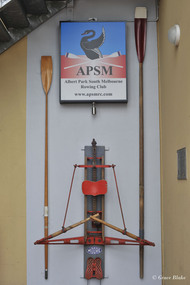 Albert Park-South Melbourne Rowing Club
Moore Sculling Machine
"Grace Blake’s conversations with older members of the Club have elicited the following information during July 2014: • Don Christie recalls the machine being acquired by (or donated to) SMRC in the 1960s. SMRC later donated it to APRC. • Bob Duncan remembers it being at APRC. • Max Shaw joined the club in 1946 but doesn’t recall it at all. • Peter Watson recalls collecting the rowing machine from the old APRC club house before its demolition (c. 1995). The AP-SMRC machine carries a ‘maker’s plate’ with the name Moore... Moore Crane and Engineering Company Pty Ltd was a subsidiary of Malcolm Moore Industries Ltd whose manufacturing engineering works were located on Williamstown Road, Port Melbourne from 1927. The founder established the main business in 1921 and retired in 1953.21 The business was delisted from the Australian Stock Exchange in 1976. Grace Blake advises that some of the earlier SMRC members were plumbers and therefore worked in trades connected with engineering. She reports that Peter Watson recalls some of his contemporaries completing their engineering apprenticeships at Malcolm Moore Industries Ltd in the 1970s. There are still many unanswered questions concerning the history and provenance of the rowing machine at the time of writing this report, but the connection with a local engineering works is certainly fascinating. Questions to explore in the future include: Did Moore manufacture the machine, or import it (and perhaps assemble it) under licence? Was this machine a ‘one-off’ or did Moore make / distribute others within Australia? When, why and how did SMRC acquire the machine? Why did SMRC decide not to retain it, but to pass it over to APRC? And how did APRC use it?" 2014 Significance Assessment, pp38-40. "The ‘Moore’ Rowing Machine at the Albert Park – South Melbourne Rowing Club (AP- SMRC) is a rare example in Australia of the Kerns patent design from 1900. This machine may not, however, be that old in construction or use. The AP-SMRC machine is almost intact, appearing to lack only the leather straps for fastening the rower’s feet to the foot-rests. Spalding manufactured the design in the USA in the early decades of the 20th century, but the metal elements in its models are traditionally black. The bright red paint on the AP-SMRC machine suggests something different. The AP-SMRC machine carries a maker’s plate that associates it directly with a local engineering business, Malcolm Moore Industries Ltd of Williamstown Road, Port Melbourne. Club members recall the machine being at the South Melbourne Rowing Club in the 1960s, and being transferred at a later date to the Albert Park Rowing Club. The machine has not been used since the founding of the amalgamated AP-SMRC and requires careful conservation. The ‘Moore’ rowing machine is of national research significance as a rare survivor, in Australia, of the well-regarded Kerns patent design that was popularised by Spalding in the northern hemisphere. The English River and Rowing Museum website quotes a testimonial from an AG Spalding & Bros’ Mail Order Catalogue: ‘This machine was described by ‘an experienced oarsman’ ... “to be the most perfect rowing machine ever produced”. A feature was the adjustment of the resistance so “the weaker sex can use the machine”’. Its historic significance lies in its rarity (and perhaps uniqueness) as an aid to the training of rowers at two successful clubs on Albert Park Lake. Additional historic significance lies in the connection that the rowing machine represents between local rowing clubs and a major local manufacturing engineer. The ‘Moore’ rowing machine bridges the realms of innovation and application, of industry and recreation, of land-based and aquatic sports, and of two neighbouring rowing clubs on the Albert Park Lake." 2014 Significance Assessment, p43"A rowing machine that appears to be built to the Kerns patent design from 1900 but may not be that old in construction or use. The machine is heavy and includes parts made from cast iron. The cast iron components are painted in a distinctive bright red. The wooden seat moves on timber slides. Resistance is created by spring mechanisms at the ends of two frame elements that connect with two wooden ‘oars’, and by the central chain-driven system that co-ordinates with the rower’s movements. The machine carries a maker’s plate with the single word ‘Moore’ in an oval design, using white letters against a navy background, fastened to the base board and close to the foot-rests." 2014 Significance Assessment, p38Moorerowing, apsm rowing club, significance assessment, malcolm moore industries ltd, kerns, 1900, sculling machine, albert park rowing club, south melbourne rowing club, albert park lake, rowing machine, ergo -
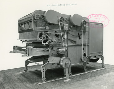 National Wool Museum
Photograph - Product Photograph, Automatic Feeding Machine
These are sales photographs for William Tatham Ltd. of Rochdale. These photographs are taken in the fitting shop at William Tatham Ltd. where final assembly would have taken place. The Automatic Feeding Machine automatically dispenses wool to a carding machine, so that an even, constant supply is received. This eliminated the manual labour previously needed for the initial weighing and feeding of wool. The photographed machine was made by William Tatham Ltd, a textile engineering company based in Rochdale, UK. Established in 1866, Tatham developed innovative textile machinery and sent their products to Australia and other countries around the world.Two black and white photos of an Automatic Feeding Machine in a landscape format. The first photo is of the front of the machine, the second is of the rear.8037.1 - Front - top margin: For description see over. Front mide right edge - Wm. TATHAM Ltd. ROCHDALE. Machine Maker Front bottom right corner - 1146 Rear - 78” wide Automatic Feeding Machine having Dual Hoppers in which the first and large section feeds the second Hopper so as to maintain a constant level of material in the latter. The driving of both spiked lattices is by electro-magnetic clutches, the one in the first Hopper being actuated by a sensitive feeler motion in the second, the second spiked lattice however, being controlled, of course, from the Scale Pan. Through a mercury switch. The scale is of our latest super-sensitive pattern mounted diagonally across the Feed. Only the opening doors are used in the actual weighting and the trap doors placed over the scale which close immediately the correct weight is deposited, operate through a solenoid. The machine incorporates many other features and is arranged to divide for facility in cleaning. 8037.2 - Front mide right edge - Wm. TATHAM Ltd. ROCHDALE. Machine Maker Front bottom right corner - 1147 Rear - Showing opposite side of Dual Automatic Feed illustrated in photo 1146textile machinery, automatic feeding machine, tatham, feeding machine