Showing 255 items
matching gold mining site
-
 Victorian Interpretive Projects Inc.
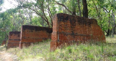
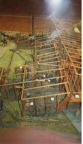
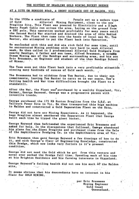
Photograph-colour, LJ Gervasoni, Jubilee Mine Scarsdale Victoria, 19/03/2011
The Jubilee Mine at Scarsdale was started by Thomas Greenwood of Italian Gully.Jubilee Company Quartz Gold Mine has one of the most comprehensive range of quartz mining foundations in the State. The brick and concrete foundations cover pumping, winding and crushing operations, as well as cyaniding of mine tailings. The machinery foundations are the remnants of large scale quartz mining operations carried on at the site between 1899 to 1912. During this time the mine produced over 125,000 ounces of gold and was the district's most important gold mine. (Source Victorian Heritage Register http://vhd.heritage.vic.gov.au/vhd/heritagevic/?timeout=yes#detail_places;5517)colour photograph in digital format showing the brick foundations of the stamping plant at the Jubilee Mine in Scarsdale, Victoria.gold mine mining scarsdale -
 Daylesford & District Historical Society
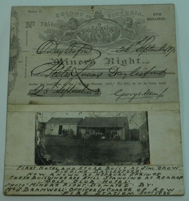
Miner's Right & Photograph, Miner's Right Pietro Lucini, Daylesford and Photograph of first hotel & stores at Jim Crow now Hepburn
Pietro Lucini owned the building on the right in the attached photograph. He operated a general store here prior to building a new building opposite this site. He was involved in gold mining activities in the early settlement of Spring Creek, now known as Hepburn Springs. Dr Francesco operated a store in building on left. A document and photograph glued on cardboard. 01451.1 Miner's Right, No. 7351. Glued on cardboard. 01451.2 A separate photograph of two early stores at early Jim Crow diggings, now Hepburn Springs. Text at bottom of photograph, " First hotel and store built at Jim Crow Diggins Daylesford. Now known as Hepburn Springs. These buildings are still standing at rear of "Golf Club Hotel. Photo Miner's Right donated by Mr J Bramwell Officer in charge of Kew Fire Station. Sept 1936". Back of cardboard has the following writing; "Donated by Mr J Bramwell Officer in Charge of Fire Station, Walton St. Kew. Sept 1936", "Donated by Beryl Jean Frame (per Mrs.R.Bland Ferntree Gully) 1987", "Box 4", WINGRAM 47 Victoria Road Auburn Melb 1- JAN 1940, Daylesford & District Historical Society.gold mining, lucini, buildings, hotel, spring creek, golf club hotel -
 Myrtleford and District Historical Society
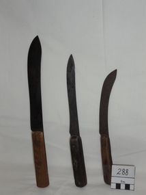
Butcher's Knives, Circa 1850
Knives were retrieved from the shipwreck of the "Schomberg" at Curdies River, Western Victoria on December 26, 1855 by Joseph Paul, who subsequently moved to the Myrtleford district.A shipwreck retrieval which assisted the Paul family to establish a business to supply the gold mining fraternity with provisions after their arrival (via Beechworth) from 1857. The provender's site then became known as the Myrtle Creek HotelSteel butcher's knives with rivetted wooden handles and curved blades.Engraved "Pipe Brand"butcher's tools schomberg paul family -
 Myrtleford and District Historical Society
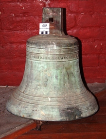
School Bell, Circa 1885
The bell was installed in the late 1880s at Myrtleford State School 955, Elgin Street, Myrtleford and rang there until the school relocated to a new site in early 1939. The bell followed the pupils to O'Donnell Avenue, but was dismantled and placed in storage in the 1950s. This bell is tied to the early daily life of state schooling in Elgin Street, from the commencement of the decline of gold mining in the district until immediately before the outbreak of World War 2. It is also related to the daily lives of children who participated in the "consolidation" of state schooling at O'Donnell Avenue and the development of "higher elementary" education.Large complete brass school bell with steel tongue.Inscription: "C. Wilson & Co., Founders, Glasgow, A.D. 1885"school bell c. wilson & co., glasgow myrtleford state school 955 -
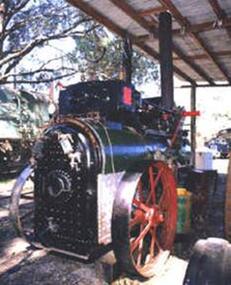 Puffing Billy Railway
Portable Compound Steam Engine, Marshall & Son's - Builders Number 48317, circa 1908 / 1909
Portable Compound Engine - Marshall & Son's. Builders Number 48317 Built by Marshall Sons & Co., Ltd., Gainsborough, England (Builder’s Number 48317 of approximately 1908/1909), to the order of Robison Brothers, Engineers, South Melbourne. It was used for operating a pump to supply irrigation water at Robinvale in Northern Victoria. Robison Bros & Co. P/L was founded by James McFarlane Robison and his brothers in 1854, initially as plumbers and coppersmiths, the firm expanded into general engineering, boiler-making and brass, iron and steel founders and became one of Melbourne's most important engineering firms. They constructed railway bridges, gold mining equipment, railway locomotives, pumping stations, brewing vessels, abattoir machinery, amongst much else and including the first turnstiles at the Melbourne Cricket Ground. A portable engine is either a steam engine or an internal combustion engine, that remains in one place while operating (providing power to machinery), and can be easily moved from one work site to another. Mounted on wheels or sometimes skids, it is required to be towed between work sites.Historic - Industrial Portable Compound Engine - steam engine - Marshall & Son's. Marshall & Son's Portable Compound Engine - Builders Number 48317 made of steel Marshall & Son's. Builders Number 48317puffing billy, state rivers and water supply commission of victoria, portable compound engine - marshall & son's., portable compound engine, marshall sons & co., ltd., robison bros & co. p/l -
 El Dorado Museum Association Inc.
Photograph (item) - Digital Image
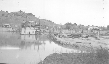
Cocks Pioneer Ponds, c. 1930s. Cocks Pioneer Electric Gold & Tin Mine Company was formed in 1899. The company's first power station, located at the eastern end of the valley began operating with its 340 Kilowatt steam-powered generator. By 1909, from 2,500,000 cubic yards worked, reported recovery was 17,284 ounces of gold and 224 tons of tin ore. By 1909, Cocks Pioneer’s power plant had become inadequate and uneconomical. The barge was floated downstream about a mile, but lost time caused the operations to cease. Following testing, a new mine was established by diverting Reid's Creek at a cost of £25,000. Settling dams were built, one of which held 1,935,900 cubic feet. Sold earth banks, built against a wall of stringy bark saplings constructed and laced with vertical props, were built. In 1914, the company was reformed as Cock’s Pioneer Gold and Tin Mines NL, another power station was constructed at the western end of the township, near the junction of Clear and Reid's Creeks. From 6,800,000 cubic yards of material processed, the returns were 64 397 ounces of gold and 855 ton of tin. Cocks Pioneer mine then moved the barge downs stream and continued sluicing. In 1929 Cocks Pioneer Electric Gold and Tin Mining Company ceased operations due to a drop in values. Cock’s Pioneer Gold and Tin Mines NL carried on large-scale hydraulic sluicing operations until 1941. mining, gold, tin, gold mining, tin mining, cocks pioneer, el dorado, eldorado -
 El Dorado Museum Association Inc.
Photograph (item) - Digital Image
Cocks Pioneer Barge. Cocks Pioneer Electric Gold & Tin Mine Company was formed in 1899. The company's first power station, located at the eastern end of the valley began operating with its 340 Kilowatt steam-powered generator. By 1909, from 2,500,000 cubic yards worked, reported recovery was 17,284 ounces of gold and 224 tons of tin ore. By 1909, Cocks Pioneer’s power plant had become inadequate and uneconomical. The barge was floated downstream about a mile, but lost time caused the operations to cease. Following testing, a new mine was established by diverting Reid's Creek at a cost of £25,000. Settling dams were built, one of which held 1,935,900 cubic feet. Sold earth banks, built against a wall of stringy bark saplings constructed and laced with vertical props, were built. In 1914, the company was reformed as Cock’s Pioneer Gold and Tin Mines NL, another power station was constructed at the western end of the township, near the junction of Clear and Reid's Creeks. From 6,800,000 cubic yards of material processed, the returns were 64,397 ounces of gold and 855 ton of tin. Cocks Pioneer mine then moved the barge downs stream and continued sluicing. In 1929 Cocks Pioneer Electric Gold and Tin Mining Company ceased operations due to a drop in values. Cock’s Pioneer Gold and Tin Mines NL carried on large-scale hydraulic sluicing operations until 1941. mining, gold, tin, barge, sluicing, gold mining, tin mining, cocks pioneer, el dorado, eldorado -
 El Dorado Museum Association Inc.
Photograph (item) - Digital Image
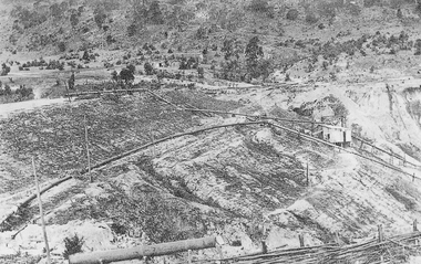
Cocks Pioneer Electric Gold & Tin Mine Company was formed in 1899. The company's first power station, located at the eastern end of the valley began operating with its 340 Kilowatt steam-powered generator. By 1909, from 2,500,000 cubic yards worked, reported recovery was 17,284 ounces of gold and 224 tons of tin ore. By 1909, Cocks Pioneer’s power plant had become inadequate and uneconomical. The barge was floated downstream about a mile, but lost time caused the operations to cease. Following testing, a new mine was established by diverting Reid's Creek at a cost of £25 000. Settling dams were built, one of which held 1,935,900 cubic feet. Sold earth banks, built against a wall of stringy bark saplings constructed and laced with vertical props, were built. In 1914, the company was reformed as Cock’s Pioneer Gold and Tin Mines NL, another power station was constructed at the western end of the township, near the junction of Clear and Reid's Creeks. From 6,800,000 cubic yards of material processed, the returns were 64,397 ounces of gold and 855 ton of tin. Cocks Pioneer mine then moved the barge downs stream and continued sluicing. In 1929 Cocks Pioneer Electric Gold and Tin Mining Company ceased operations due to a drop in values. Cock’s Pioneer Gold and Tin Mines NL carried on large-scale hydraulic sluicing operations until 1941. gold, tin, mining, sluicing, gold mining, tin mining, cocks pioneer, el dorado, eldorado -
 El Dorado Museum Association Inc.
Photograph - Digital Image
Construction of New Barge, Cocks Pioneer. Cocks Pioneer Electric Gold & Tin Mine Company was formed in 1899. The company's first power station, located at the eastern end of the valley began operating with its 340 Kilowatt steam-powered generator. By 1909, from 2,500,000 cubic yards worked, reported recovery was 17,284 ounces of gold and 224 tons of tin ore. By 1909, Cocks Pioneer’s power plant had become inadequate and uneconomical. The barge was floated downstream about a mile, but lost time caused the operations to cease. Following testing, a new mine was established by diverting Reid's Creek at a cost of £25 000. Settling dams were built, one of which held 1,935,900 cubic feet. Sold earth banks, built against a wall of stringy bark saplings constructed and laced with vertical props, were built. In 1914, the company was reformed as Cock’s Pioneer Gold and Tin Mines NL, another power station was constructed at the western end of the township, near the junction of Clear and Reid's Creeks. From 6,800,000 cubic yards of material processed, the returns were 64,397 ounces of gold and 855 ton of tin. Cocks Pioneer mine then moved the barge downs stream and continued sluicing. In 1929 Cocks Pioneer Electric Gold and Tin Mining Company ceased operations due to a drop in values. Cock’s Pioneer Gold and Tin Mines NL carried on large-scale hydraulic sluicing operations until 1941. mines, mining, gold, tin, gold mining, tin mining, sluicing, barge, construction, cocks pioneer, el dorado, eldorado -
 El Dorado Museum Association Inc.
Photograph - Digital Image
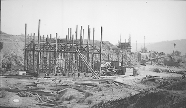
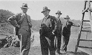
Four men touring near the Cock’s Eldorado Gold and Tin Mining Dredge building site. Cropped image from scanned sheet of negative proofs. Cock's El Dorado Gold & Tin Mining Dredge operated between 1936 and 1954. At the time of its construction, the dredge was the largest in the Commonwealth, producing 2,198 kg of gold.mines, mining, gold, gold mining, men, hats, cock's el dorado dredge, dredge, el dorado, eldorado -
 Tatura Irrigation & Wartime Camps Museum
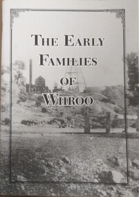
Booklet, The Early Families of Whroo
Tells a short story of the early families who settled at Whroo, a gold mining area, located near Rushworth. The town is no long in existence. Written by Doris KIngA5 size booklet with soft cardboard cover. Cover has a black frame in from the edge with the book title in that in black print. Cover is a grey scale photograph of the Whroo mining site. 88 pages.titlewhroo, families of whroo, doris king -
 Tatura Irrigation & Wartime Camps Museum
Book, The Pennyweight Kids, 1988
Written to try to discover why more than 200 children died at Forest Creek, Victoria. Stories of their families.Yellow cover, sketch of scales 1852-1857. Gold mining scene and grieving mother. On back cover sketch of excavation of old burial site. London 1852. Gentleman's Magazine.forest creek victoria, deaths at forest creek victoria -
 City of Ballarat
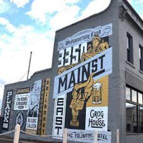
Artwork, other - Public Artwork, Travis Price, Main Road Mural by Travis Price, May 2018
Whilst my main focus for the artwork design was on the Hotels on Main Road, I felt there was an opportunity to tell a broader story of Main Rd and combine/include some interesting pieces of information from many stages of the history of Main Road. Considering that at one point in time there would have been at more than six hotels in this very short section of street….there’s no doubt Main Rd was an epicentre of communication and festivities for the Goldfields of Ballarat. “No matter what luck he had, every miner needed supplies, food and something to entertain him when he was not searching for gold.” Described as being an overcrowded jumble of muddy streets loosely arranged around mining camps...and loud, muddy, colourful and sometimes illicit. I wanted the artwork composition to consist of overlapping images and text to reflect this sense of hustle and bustle. Main Road Mural tells the broader story of the history of Main Road in Ballarat. In 2018, the City of Ballarat commissioned local Ballarat artist Travis Price to create an artwork to align with the Main Road Revitalisation Project and deliver a key component of the storytelling (heritage interpretation) project that spans the length of the shopping precinct. The artwork is featured on a prominent site in the shopping precinct of main road and tells the story of Main Road through depicting key timeline events. Main Road, as its name suggests, was one of the main entries to the mining areas of East Ballarat. It had several names: Main Street before 1858, Plank Road between 1858 and 1868 and Main Road from 1868 onwards. The centre of mining life, it was crowded, prosperous, raucous and dirty. Painted mural on shop wall in Main Road, BallaratBallaarat, Gold Fever, The Royal Standard Hotel, Flood, Boxing Saloon, Plank Road, Kulin Nation, 3350, Election, East, Grog House, The Scandinavian Hotel. Images; Chinese lantern, Pick & Shovel, Miners Licence burning.main road history, ballarat hotels, gold fever, wadawurrung, kulin nation -
 Clunes Museum
Photograph, Jul-01
MODEL MADE BY CARL NORDSTROM ON THE PORT PHILLIP MINE SITE IN 1858. NOW ON DISPLAY AT THE SCIENCE MUSEUM IN MELBOURNE *No longer on display, now archived. ON LOAN TO THE CLUNES COMMUNITY DURING THE 150TH GOLD CELEBRATIONS IN JULY, 2001, AND DISPLAYED IN THE ALL PURPOSE ROOM AT CLUNES PRIMARY SCHOOL.4 COLOURED PHOTOGRAPHS OF THE PORT PHILLIP MINE MODELlocal history, photography, photographs, mining -
Clunes Museum
Sign - DISPLAY PANEL, 2000
COPIES OF DISPLAY PANELS DONATED TO THE PEOPLE OF CLUNES BY THE HUGH WILLIAMSON FOUNDATION.INTERPRETIVE DISPLAY PANEL DEPICTING HISTORY OF SCHOOL DAYS IN CLUNES. WOODEN DISPLAY PANEL AND LAMINATED COPY.SCHOOL DAYS CHILDREN OF EARLY GOLDFIELD TOWNS WERE TAUGHT IN TENT SCHOOLS.THESE SCHOOLS WERE EASILY MOVED TO THE SITE OF THE LATEST GOLDRUSH. WITH GREATER COMMUNITY STABILITY PERMANENT SCHOOLS WERE ESTABLISHED. CLUNES STATE SCHOOL NO. 1552 WAS OPENED IN JULY 1875 ON LAND DONATED BY RIVETT H. BLAND, MANAGER OF THE PORT PHILIP GOLD MINING CO. SHORTLY BEFORE WORLD WAR ONE, THIS SCHOOL BECAME VICTORIA,S THIRD HIGHER ELEMENTARY SCHOOL. TODAY IT IS STILL USED TO EDUCATE THE CHILDREN OF CLUNES STATE SCHOOL NO. 136 WAS BUILT IN 1881 ON THE SITE OF AN EARLIER TEMPORARY SCHOOL THAT WAS BUILT IN 1857. THE DESIGN WAS FIRST USED AT HORSHAM. AND INCLUDES AN EARLY EXAMPLE OF A LARGE SCHOOL VERANDAH. IN 1892 THIS SCHOOL AMALGAMATED WITH STATE SCHOOL NO. 1552 AND WAS USED AS THE INFANT SCHOOL. IT CLOSED ITS DOORS IN 1922 AND WAS LATER USED AS A MILL FOR THE CLUNES KNITTING AND MAUFACTURING CO. LTD. IT NOW HOUSES THE CLUNES BOTTLE MUSEUM THE CLUNES CATHOLIC SCHOOL OPENED IN 1875 AND CLOSED IN 1926 THE LATEST EDUCATIONAL ASSET AT CLUNES IS A CAMPUS OF WESLEY COLLEGE. BLENDINGHISTORIC BUILDINGS AND MODERN ARCHITECTURE THE CAMPUS IS SITUATED IN SERVICE STREETlocal history, civic momentoes, presentations, williamson, hugh foundation -
 Clunes Museum
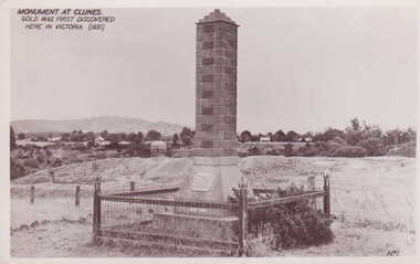
Photograph - PHOTOGRAPH MONUMENT
MONUMENT BUILT AND ERECTED ON SITE OF FIRST GOLD DISCOVERY IN VICTORIA 1851. PORT PHILLIP MINE.BLACK AND WHITE POSTCARD OF A BRICK MONUMENT SURROUNDED BY WOOD AND WIRE MESH FENCE WITH CAMP PARADE AND MOUNT BECKWORTH IN BACKGROUND. PLAQUE ON CEMENT BASE OF BRICK PILLAR.MONUMENT AT CLUNES. GOLD WAS FIRST DISCOVERED HERE IN VICTORIA 1851.photography, monuments, memorials& mining -
 Clunes Museum
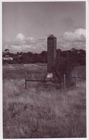
Photograph - PHOTOGRAPH MONUMENT
GOLD MONUMENT ERECTED ON SITE OF FIRST GOLD DISCOVERY IN VICTORIA 1851BRICK MONUMENT, SURROUNDED BY MESH FENCE WITH WOODEN POSTS. GRASS GROWING AROUND MONUMENT, MULLOCK HEAPS IN BACKGROUND, HOME ON CAMP PARADE.GOLD MONUMENT CLUNESphotographs, mining civic momentoes, gold monument -
 Stawell Historical Society Inc
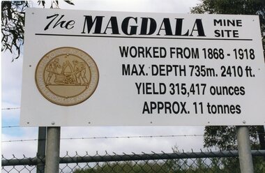
Photograph, Kevin Patterson, Magdala Mine Site sign and Shaft, Circa 1999
3 Colour Photgraphs: 2 showing information about the mine , the other showing the shaft covered with protecive mesh.Sthe Sign Reads: The Magdala mine site worked from 1868 -1918. Max Depth 735 M. 2410 ft. Yeild 315,417 Ounces Approx 11 Tonnes On Revese: Gold Miners Stawell. Neg 20 mining, magdala -
 Stawell Historical Society Inc
Photograph, Magdala Shaft, 1986
7082a: - Induction fan discharge from the Stawell Gold MIne, this gunck would include the diesel fumes of trucks and mining machines. The steam Plume drifts over the nearby trees blackening and killing the. It also drifts over the reservior adding a touch of spice to the town's drinking water. site closed in 2001. Another fan is located near to Darlington Lane and McLennan Street.2 Photographs: 7082:Showing workmen drilling a shaft with a car in the background 7082a: Showing Steam? coming from the shaft.On Reverse: 7082 Mick Walsh 52 Patrick Street Phone 053 ******mining -
Stawell Historical Society Inc
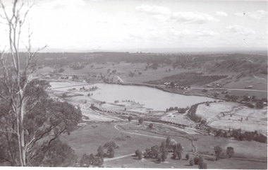
Map, Township of Stawell Photo Map, 1947
Photograph of Stawell from Air Circa 1947. Shows mining sites and townshipmining, gold, map -
Stawell Historical Society Inc
Map, Western Mining Corp / Stawell Joint Venture, Stawell & District with Mine Working Areas shown in red, 1987
Covers from Magdala East site to Germania in North and Hand in Hand at West Legend of Mine workings numbered. 1980's mining, gold, map -
Stawell Historical Society Inc
Map, Stawell Joint Venture, Mine Site Detail Plan, September 1989
... grampians mining gold map 1989 Mine Site Detail Plan Map Stawell ...1989mining, gold, map -
Stawell Historical Society Inc
Map, Stawell Gold Mine, Milling Area Site Arrangement 2002, 12/6/2002
Plus Bench Mark Levels Stawell Gold Mines Victoria Scale 1 : 20000mining, gold -
Whitehorse Historical Society Inc.
Article, Old gold mine site is found
The exact site of the old goldmine in the Lake Road - Halley Street area of Blackburn was located and identified by local history investigators.The exact site of the old goldmine in the Lake Road - Halley Street area of Blackburn was located and identified by local history investigators. Ray Champion said it was on a property he owned, his father Isaac Champion had filled in the mine in 1904. The mine had successfully operated up until about 1880.The exact site of the old goldmine in the Lake Road - Halley Street area of Blackburn was located and identified by local history investigators. mines and mining, champion, isaac, ray, halley street, blackburn, lake road, dickens street, goldmining -
 Whitehorse Historical Society Inc.
Document, Dickens Street, Blackburn
Auction of housing development in Dickens Street, Blackburn, comprising 25 sites, leading off Lake Road. Agent Frank Fisher & Co.dickens street, blackburn, frank fisher co., lake road -
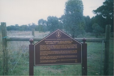 Rutherglen Historical Society
Image, 2004
Colour photograph of a story board marking former site of a gold processing cyanide plant at Christmastown. Photo is mounted on an album page.storyboards, working miners gold mining co, gold mining, cyanide plant -
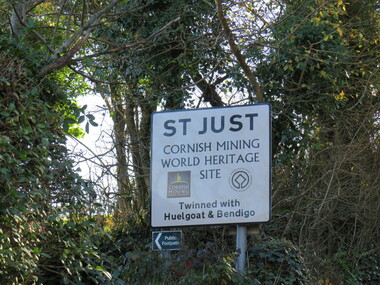 Ballarat Heritage Services
Photograph - Colour, Sign, St Just, Cornwall
Many miners came from the St Just are in Cornwall to Ballarat, Victoria, Australia for the gold rushes. This sign reads that St Just, Cornwall is a Cornish Mining World Heritage Site twinned with Huelgoat and Bendigo.ellis, st just, bendigo, miners -
 Ballarat Heritage Services
Photograph, Mullock Heap In Victoria Park, Ballarat, 2014, 04/11/2014
The large mullock heap, marks the site of a former quartz mine, and is one of the few visible signs of the former presence of extensive gold mining activities in this area of Ballarat. Originally known as Park Mine, and now known as Mount Holled Smith, the mine associated with this mullock heap puddled 750 tons of washdirt each day. The mine closed down in 1874, at which time 94,699 ounces of gold had been removed from the ground. Colour photograph of a mullock heap in Ballarat's Victoria Park.mullock heap, ballarat gardens, victoria park, park mine -
 Lions Club of Maldon Inc.
Document, The History of Dragline Gold Mining Bucket Dredge at a site on Bendigo Road
-
 Old Colonists' Association of Ballarat Inc.
Photograph - Photograph - Colour, Ballarat Old Colonists' Association Homes, Charles Anderson Grove, Ballarat
HISTORY OF THE BALLARAT OLD COLONISTS' ASSOCIATION HOMES AT CHARLES ANDERSON GROVE, LAKE GARDENS One of the original objectives of the Association was “to provide the shelter of a house for those Pioneers of the Goldfields whom the reverses of fortune have deprived of the means of procuring the comforts of life in their declining years.” While the first home at Charles Anderson Grove was built in 1925 the Association had previously provided relief for needy pioneers from the time it was formed in 1883. Relief included monthly monetary payments, loads of firewood, medical assistance and distribution of Christmas boxes of groceries to deserving pensioners and in some cases payment of burial costs. Records indicate that in September 1922 three of the pensioners being assisted by the Association were accepted as residents in the newly erected Hassell Homes in Gillies Street (now demolished-opposite the High School). The first site for an Asylum for Indigent Members of the Old Colonists' Association was temporarily reserved from sale in October 1891. The site was approximately 28 acres in area in Mt Clear nearly opposite Midvale Shopping Centre in Main Road. The site was heavily timbered and when cleared over 260 tons of wood was sold to the Woah Hawp Gold Mining Company. A set of gates were erected but no homes built, although a plan for this reserve was drawn which showed twenty buildings ranging from one to four unit per building. The reserve was revoked in November 1909. The second site temporarily reserved in November 1909 as an Asylum was in Alfredton and consisted of some 7 acres and was adjacent to land reserved for an Abattoirs for the Ballarat Council. The reserve was revoked in February 1912 as it was deemed more appropriate to be added to the Abattoir site. Council suggested four (4) other sites in exchange for this land and they were inspected by the President, Vice President and Secretary on 22 December 1912. The first site inspected was land on the west side of Creswick Road opposite the brick kilns (now occupied by the showgrounds and oval). The land was described as being good quality, well fenced, no trees, good drainage and ample acreage but some distance from trams. The second site was Perry Park which was described as being good land, well fenced, having frontage to Gillies Street, good drainage and about 26 acres (but subsequently reduced to 10 acres). It was closely planted with Pinus Insignias and Wattle and had easy access from the Botanic Gardens tram. The third site was the North West portion of Victoria Park (corner of Sturt and Gillies Street) and was described as good land, well fenced and drained and well located. The fourth site was the South West corner of Victoria Park and known as Pound Paddock (corner of Winter Street and Gillies Street). It was considered to be low lying and too close to the Abattoir, and was also a considerable distance from trams. While the third site was recommended as the most suitable for the erection of homes it was considered unwise from the point of view as citizens to reduce the acreage of the park and therefore it was recommended that the Perry Park site be asked for as the most acceptable to the Association for the building of homes. The site was eventually temporarily reserved for an Asylum for Indigent Members of the Association in April 1914 with the gates from Mt Clear having been removed to the site a year earlier and eventually erected in 1917 for £12.10.0. In the same year the first 290 pine trees were advertised for removal in July and sold for £16. A sign indicating that the site was reserved for the erection of cottages was erected in September 1917. Stripping of the wattle bark (for tanning) and the cutting of the wood occurred in November 1918 with the land then being leased until it was required for the construction of the first homes in 1924. While the site was the third to be reserved it was the only one which was used for its intended purpose. It was named as Charles Anderson Grove in honour of Charles Anderson who joined the Association in 1918 and was President of the Association from 1942 to 1944. A number of cottages in the Ballarat Old Colonists' Association Retirement Village of Gillies Street, Ballarat.charles anderson grove, old colonists' club, ballarat, old colonists' association, old colonists' homes, retirement village