Showing 175 items matching "harp road"
-
 Whitehorse Historical Society Inc.
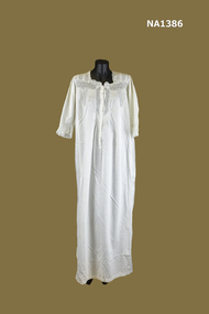
Clothing - Nightdress
White cotton Nightdress with square neckline and long sleeves. Bobbin lace decoration at neck and cuffs. Lattice lacing borders the bobbin lace. Fine pintucking eyelet lace at neck and cuffs. Bobbin lace backed by fine mesh . Four pearl buttons concealed in front placket.Harper Lcostume, female nightwear -
 Whitehorse Historical Society Inc.
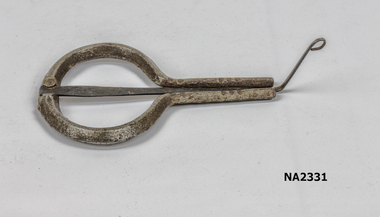
Audio - Jews Harp
Round metal instrument with three prongs.musical instruments, percussion -
 Whitehorse Historical Society Inc.
Audio - Audio Cassette, Maureen van Twest
Interview with Maureen van Twest on 29th March 2006. She emigrated to Australia from Sri Lanka in 1968. Interviewed by Jan Harper.Oral History - Interview with Maureen van Twest on 29th March 2006. She emigrated to Australia from Sri Lanka in 1968. Interviewed by Jan Harper. van twest maureen, emigration, oral history migration program, sri lankans in australia -
 Kew Historical Society Inc
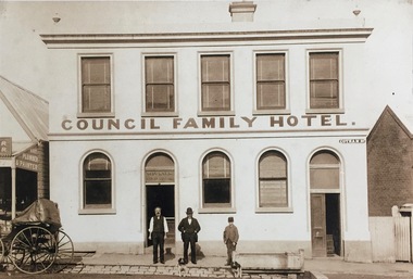
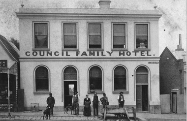
Photograph - Photograph [copy], Council Family Hotel, Cotham Road, circa 1888, c.1888
The Council Family Hotel was the fifth of the eight hotels to be licensed in Kew during the 19th Century. They were licensed in the following date order: The Woodman Inn (1854), The Harp of Erin (1854), O’Shaughnessy’s Kew Hotel (1855), the Prospect Hill Hotel (1858), the Council Family Hotel (1861), the Princess Hotel (1864), the Clifton Hotel (1868) and the Greyhound Hotel (1873).Rare photograph of a landmark Kew HotelExterior - Council Family Hotel, Cotham Road, Kew, circa 1888.Mr Pat Ryan in doorwayhotels - kew, council family hotel - kew (vic) -
 Kew Historical Society Inc
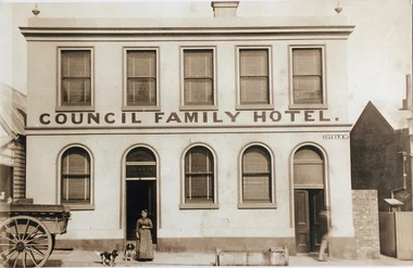
Photograph - Photograph [copy], Council Family Hotel, Cotham Road, circa 1888, c.1888
The Council Family Hotel was the fifth of the eight hotels to be licensed in Kew during the 19th Century. They were licensed in the following date order: The Woodman Inn (1854), The Harp of Erin (1854), O’Shaughnessy’s Kew Hotel (1855), the Prospect Hill Hotel (1858), the Council Family Hotel (1861), the Princess Hotel (1864), the Clifton Hotel (1868) and the Greyhound Hotel (1873).Rare photograph of a landmark Kew hotelExterior - Council Family Hotel in Cotham Road, Kew (Vic) with Mrs Ryan, wife of the licensee at frontMrs Ryanhotels - kew, council family hotel - kew (vic), licenees - ryan family -
Kew Historical Society Inc
Archive (Sub-series) - Subject File, Kew Historical Society, Household Lists & Accounts [Kew et al], 1958
Various partiesReference, Research, InformationSecondary Values (KHS Imposed Order)Two miscellaneous sets of documents. One is an auction catalogue of the contents of Lauriston, 7 Laura Street, Moonee Ponds, by Graham & Harper (1923). The second includes items relating to 60 Normanby Road, owned by Mr Walter Joseph Martin (amongst others), and includes a copy of a Certificate of Title (including owners between 1923-80), insurance papers (1926, 1935-6), MMBW rates (1933, 1934) Council Rate Notices (1933, 1935), and mortgage payments (1928, 1929, 1933).lauriston - 7 laura street moonee ponds, 60 normanby road - kew (vic), george frederick frieberg, george william wray bennett, maxwell howard martin, bessie may martin, walter joseph martin, gertrude daisy martinlauriston - 7 laura street moonee ponds, 60 normanby road - kew (vic), george frederick frieberg, george william wray bennett, maxwell howard martin, bessie may martin, walter joseph martin, gertrude daisy martin -
 Kew Historical Society Inc
Photograph - Photograph [copy], Council Family Hotel, Cotham Road, circa 1888, c.1888
The Council Family Hotel was the fifth of the eight hotels to be licensed in Kew during the 19th Century. They were licensed in the following date order: The Woodman Inn (1854), The Harp of Erin (1854), O’Shaughnessy’s Kew Hotel (1855), the Prospect Hill Hotel (1858), the Council Family Hotel (1861), the Princess Hotel (1864), the Clifton Hotel (1868) and the Greyhound Hotel (1873).Rare photograph of a landmark hotel in KewExterior - Council Family Hotel, Cotham Road, Kew, circa 1888.hotels - kew, council family hotel - kew (vic) -
 Kew Historical Society Inc
Photograph - Looking towards Kew from Strathalbyn Street and High Street, c.1916
An electrified tram route from Melbourne along High Street replaced an original Horse Tram that terminated at the Kew Cemetery. This new tram only reached the bridge over the Outer Circle railway at the Harp Junction. The line was later extended to North Balwyn.Black and white print positive showing the view west along High Street, Kew (formerly Bulleen Road). In the centre distance is the Boroondara General (Kew) Cemetery. In the foreground, the road crosses the Outer Circle railway. The photograph reflects the level of urbanisation in Kew during the First World War. "Looking towards Kew from Strathalbyn St / High St corner, about 1916. Courtesy Mrs E Bennett, Kew East / Property of Miss Foley"trams -- kew, trams -- kew east, mmtb, m&mtb, tramways, harp junction -
Kew Historical Society Inc
Journal, Kewriosity : October 1991
Upgrading of Harp Junction [VicRoads, Kew Council] / p1. Proposed roundabout at Valerie Street, Asquith Road [and] Belford Road / p1. Chief Executive's Comment [Rates and charges for 1991/92] / Malcolm Hutchinson p2. Croquet - New season starts / p2. Kew Band / p2. Mayor's Comment [Council's Budget for 1991/92] / Cr Daryl Oldaker / p3. Diary Dates for October / p4. Diary dates for November / p5. Family Day Care [Kew/Hawthorn Family Day Care Scheme seminars] / p5. St George's [Midwifery School] / p5. Kew Youth Card / p6. Breastfeeding right from the start / p6. The future of Kew Junction / p7. 111 years of Kew bowling [Kew Bowling Club] / p7. The Adult Video-cassette collection [Kew Library] / p8. Invitation to 'Traffic in Melbourne' Community Workshop / p8. Community Planting Day / p8. Float a boat [Rotary Club of Kew fundraising to support disability access] / p8.Kewriosity was a local newsletter combining Kew Council and community news. It was published between November 1983 and June 1994, replacing an earlier Kewriosity [broad] Sheet (1979-84). In producing Kewriosity, Council aimed to provide a range of interesting and informative articles covering its deliberations and decision making, together with items of general interest and importance to the Kew community and information not generally available through daily media outlets.non-fictionUpgrading of Harp Junction [VicRoads, Kew Council] / p1. Proposed roundabout at Valerie Street, Asquith Road [and] Belford Road / p1. Chief Executive's Comment [Rates and charges for 1991/92] / Malcolm Hutchinson p2. Croquet - New season starts / p2. Kew Band / p2. Mayor's Comment [Council's Budget for 1991/92] / Cr Daryl Oldaker / p3. Diary Dates for October / p4. Diary dates for November / p5. Family Day Care [Kew/Hawthorn Family Day Care Scheme seminars] / p5. St George's [Midwifery School] / p5. Kew Youth Card / p6. Breastfeeding right from the start / p6. The future of Kew Junction / p7. 111 years of Kew bowling [Kew Bowling Club] / p7. The Adult Video-cassette collection [Kew Library] / p8. Invitation to 'Traffic in Melbourne' Community Workshop / p8. Community Planting Day / p8. Float a boat [Rotary Club of Kew fundraising to support disability access] / p8. publications -- city of kew (vic.), kewriosity, council newsletters, community newsletters -
Kew Historical Society Inc
Journal, The Kewriosity Sheet Vol.3 No.3 : September 1981
Home tutors for migrants [Jill Manton] / p1. Harp, Browse and Buy [Harp Browse and Buy Shop; Victoria Schizophrenia Fellowship] / p1. East Kew Uniting Church / p1. Spring-time Fair [East Kew Uniting Church] /p2. Do you know? [Parents of Disabled Persons] / p2. What's doing in Kew for September / p2&3 Women's Recreation Program /p3. Guest to preach at Kew Baptist Church [Rev. Brian Willersdorf] / p3. Minibus drivers and jockeys [Meals on Wheels] / p3. Hyde Park Fellowship [Hyde Park Church] / p3. Mission Spring Fair [Missionary Sisters of St Peter Claver / p3. The gateway to Kew [Charles Grimes Expedition; Johnston Street Bridge; Studley Park Road; Raheen; Campion Hall; Burke Hall; Studley House; Villa Alba] / Elizabeth Mackie p4. Council News - Family and Community Services (FACS) Programme; Community Service Grants; Deafness Awareness Week; ] / p4.The Kewriosity Sheet (1979-83) was first published in the City of Kew (Victoria) in June 1979 as a two-sided 'community newssheet'. It aimed to: 'share news about Kew happenings and Kew people, and to exchange ideas about living in Kew'. Later issues gradually evolved into a 4-page, quarto sized publication. The Kewriosity Sheet was superseded by the Kew Council publication 'Kewriosity' (1983-1994).non-fictionHome tutors for migrants [Jill Manton] / p1. Harp, Browse and Buy [Harp Browse and Buy Shop; Victoria Schizophrenia Fellowship] / p1. East Kew Uniting Church / p1. Spring-time Fair [East Kew Uniting Church] /p2. Do you know? [Parents of Disabled Persons] / p2. What's doing in Kew for September / p2&3 Women's Recreation Program /p3. Guest to preach at Kew Baptist Church [Rev. Brian Willersdorf] / p3. Minibus drivers and jockeys [Meals on Wheels] / p3. Hyde Park Fellowship [Hyde Park Church] / p3. Mission Spring Fair [Missionary Sisters of St Peter Claver / p3. The gateway to Kew [Charles Grimes Expedition; Johnston Street Bridge; Studley Park Road; Raheen; Campion Hall; Burke Hall; Studley House; Villa Alba] / Elizabeth Mackie p4. Council News - Family and Community Services (FACS) Programme; Community Service Grants; Deafness Awareness Week; ] / p4. community publications --- kew (vic.), the kewriosity sheet, newsletters - kew (vic.) -
 Kew Historical Society Inc
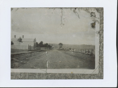
Photograph - High Street looking north to Burke Road, 1907-08
... in the eastern part of Kew looking towards Burke Road in 1907-8. Harp ...While a number of subdivisions of what was to become Kew East occurred in the 1880s, such as the 'Mount Pleasant Estate' (1888) and 'Monterey Estate' (1888), Glynn's Lot 91 remained open farmland until the Harp Estate (1912) was sold, hence the undeveloped nature of the view in 1907-8.A rare image of the open farmland in the eastern part of Kew looking towards Burke Road in 1907-8.Damaged, and very rare, black & white photograph of what was to become the suburb of East Kew, taken by a member of the Bennett family in 1907-8. The photograph is taken from the Harp of Erin Hotel showing, apart from a building on the left (no longer extant), fenced open farmland stretching into the far distance.HIGH ST LOOKING NOTRTH TO BURKE RD FROM HARP / EDWD GLYNN'S LOT 91 FROM 1851 / GIFT FROM BENNETT FAMILY 22 HARP RD EAST KEW 1980 / 1907-8harp of erin, high street -- east kew (vic), harp estate -
 Kew Historical Society Inc
Photograph - Filling in the Outer Circle Railway cutting at East Kew, 1939
W.D. Vaughan (Kew's Civic Century, 1960, pp.195-6) quotes Council Minutes of 1938 and 1939 to record that: "After protracted negotiations between the Council, the Railways Department and the Tramways Board agreement was reached in June, 1938, for the filling of the railway cutting at the Harp Junction and shifting tram tracks to the High Street alignment ... The Outer Circle railway land from Princess Street to Park Crescent was purchased by the Kew Council in October, 1939, for 2,750 [pounds]. The land from Park Crescent to High Street was leased for 1 [pound] per annum. Considerable work was done in levelling the embankments to the original surface level."Important and rare photograph of the period, showing major works by Kew Council in Kew East working on a significant piece of urban infrastructure.Small, original black and white positive (photograph) showing workers and vehicles filling in the tracks of the former Outer Circle railway at East Kew. In the background is the metal bridge with brick piers, adjacent to the Harp Junction. The bridge crossed the cutting, linking the two parts of High Street. Behind the tip truck, painted on the side with the name 'Fowler Quarries' [located Keilor Road, North Essendon], one can see shops [including T.G. Garroway, Cash Grocer] in High Street. What appears to be the City of Kew Steamroller is immediately in front of the bridge. A group of passers-by watch from the bridge and from the road. Annotation in pencil on verso: "Filling in Outer Circle line at High St East Kew prior to straightening High St. (c. Feb 1930?)outer circle railway, railway cuttings, harp junction, high street -- kew east -
 Kew Historical Society Inc
Plan - Subdivision Plan, Shop Sites, East Kew, c.1927
Subdivision plans are historically important documents used as evidence of the growth of suburbs in Australia. They frequently provide information about when the land was sold on which a built structure was subsequently constructed as well as evidence relating to surveyors and real estate and financial agents. The numerous subdivision plans in the Kew Historical Society's collection represent working documents, ranging from the initial sketches made in planning a subdivision to printed plans on which auctioneers or agents listed the prices for which individual lots were sold. In a number of cases, the reverse of a subdivision plan in the collection includes a photograph of a house that was also for sale by the agent. These photographs provide significant heritage information relating house design and decoration, fencing and household gardens.This is one of a small number of subdivision plans for commercial property in the collection. The subdivision proposed to create six shop sites in High Street between the Harp of Erin and Station Street. The plan shows this stretch of High Street, East Kew already lined with shops that include the hotel on the corner, the new State Savings Bank, a dentist’s surgery and Lambert’s Store. The High Street Tram was to reach Burke Road in 1925, so the proposed subdivision must postdate that event, and the opening of the Bank in 1926.subdivision plans - east kew, high street - east kew -
 Kew Historical Society Inc
Plan - Subdivision Plan, Harvest Home Estate, 1919
Pru Sanderson, in her groundbreaking ‘City of Kew Urban Conservation Study : Volume 2 - Development History’ (1988), summarised the periods of urban development and subdivisions of land in Kew. The periods that she identified included 1845-1880, 1880-1893, 1893-1921, 1921-1933, 1933-1943, and Post-War Development. These periods were selected as they represented periods of rapid growth or decline in urban development. An obvious starting point for Sanderson’s groupings involved population growth and the associated economic cycles. These cycles also highlighted urban expansion onto land that was predominantly rural, although in other cases it represented the decline and breakup of large estates. A number of the plans in the Kew Historical Society’s collection can also be found in other collections, such as those of the State Library of Victoria and the Boroondara Library Service. A number are however unique to the collection.The Kew Historical Society collection includes almost 100 subdivision plans pertaining to suburbs of the City of Melbourne. Most of these are of Kew, Kew East or Studley Park, although a smaller number are plans of Camberwell, Deepdene, Balwyn and Hawthorn. It is believed that the majority of the plans were gifted to the Society by persons connected with the real estate firm - J. R. Mathers and McMillan, 136 Cotham Road, Kew. The Plans in the collection are rarely in pristine form, being working plans on which the agent would write notes and record lots sold and the prices of these. The subdivision plans are historically significant examples of the growth of urban Melbourne from the beginning of the 20th Century up until the 1980s. A number of the plans are double-sided and often include a photograph on the reverse. A number of the latter are by noted photographers such as J.E. Barnes.The ‘Harvest Home Estate’ was advertised as being a subdivision in East Kew. Now, Campbell and Owen Streets on which the allotments were located are classed as being in Kew. The Estate included 11 residential allotments abutting the Outer Circle Railway line [at the end of Owen Street]. Understandably, the vendors focused on the availability of transport by tram, noting that the Estate was near the High Street tram terminus at the Harp of Erin. A small note on the subdivision advises that the Cotham Road tram was only 3 minutes away. The location – ‘The most elevated position in lovely Kew’ – was also promoted as an advantage.subdivision plans - east kew, harvest home estate -
 Kew Historical Society Inc
Plan, J R Mathers & McMillan, 5 Splendid vVlla Allotments,: Segtoune St. & Windsor St., Kew, 1928
Prue Sanderson, in her groundbreaking ‘City of Kew Urban Conservation Study : Volume 2 - Development History’ (1988), summarised the periods of urban development and subdivisions of land in Kew. The periods that she identified included 1845-1880, 1880-1893, 1893-1921, 1921-1933, 1933-1943, and Post-War Development. These periods were selected as they represented periods of rapid growth or decline in urban development. An obvious starting point for Sanderson’s groupings involved population growth and the associated economic cycles. These cycles also highlighted urban expansion onto land that was predominantly rural, although in other cases it represented the decline and breakup of large estates. A number of the plans in the Kew Historical Society’s collection can also be found in other collections, such as those of the State Library of Victoria and the Boroondara Library Service. A number are however unique to the collection.Subdivision plans are historically important documents used as evidence of the growth of suburbs in Australia. They frequently provide information about when the land was sold on which a built structure was subsequently constructed as well as evidence relating to surveyors and real estate and financial agents. The numerous subdivision plans in the Kew Historical Society's collection represent working documents, ranging from the initial sketches made in planning a subdivision to printed plans on which auctioneers or agents listed the prices for which individual lots were sold. In a number of cases, the reverse of a subdivision plan in the collection includes a photograph of a house that was also for sale by the agent. These photographs provide significant heritage information relating house design and decoration, fencing and household gardens.In 1928, five residential allotments bordering Segtoune and Windsor Streets were advertised for sale as part of a subdivision. Four of the blocks faced Segtoune Avenue. The auctioneers proclaimed the advantages of the sites: ‘Situate one minute from the High Street Electric Tram, which now runs direct to Spencer Street via Bridge Road and Flinders Street. Opposite the East Kew Railway Station (Outer Circle Line), which may be reopened In connection with the new Line from Kew to Doncaster; Adjacent lo the Kew Recreation Reserve, Sports Oval, and Swimming Bath; Half Minute from the Shopping Centre of East Kew, Accessible to the State School and Other Educational Centres’. The Harp of Erin Hotel and the route of the Outer Circle Railway line are marked on the plan. The Recreation Reserve and Sport Oval refer to Victoria Park. The Swimming Baths were located on the site of the current Kew Recreation Centre.subdivision plans - kew, segtoune street -- kew (vic.), windsor street -- kew (vic.) -
 Kew Historical Society Inc
Plan - Subdivision Plan, Belford Heights Estate, Kew, ca. 1925
Pru Sanderson, in her groundbreaking ‘City of Kew Urban Conservation Study : Volume 2 - Development History’ (1988), summarised the periods of urban development and subdivisions of land in Kew. The periods that she identified included 1845-1880, 1880-1893, 1893-1921, 1921-1933, 1933-1943, and Post-War Development. These periods were selected as they represented periods of rapid growth or decline in urban development. An obvious starting point for Sanderson’s groupings involved population growth and the associated economic cycles. These cycles also highlighted urban expansion onto land that was predominantly rural, although in other cases it represented the decline and breakup of large estates. A number of the plans in the Kew Historical Society’s collection can also be found in other collections, such as those of the State Library of Victoria and the Boroondara Library Service. A number are however unique to the collection.The Kew Historical Society collection includes almost 100 subdivision plans pertaining to suburbs of the City of Melbourne. Most of these are of Kew, Kew East or Studley Park, although a smaller number are plans of Camberwell, Deepdene, Balwyn and Hawthorn. It is believed that the majority of the plans were gifted to the Society by persons connected with the real estate firm - J. R. Mathers and McMillan, 136 Cotham Road, Kew. The Plans in the collection are rarely in pristine form, being working plans on which the agent would write notes and record lots sold and the prices of these. The subdivision plans are historically significant examples of the growth of urban Melbourne from the beginning of the 20th Century up until the 1980s. A number of the plans are double-sided and often include a photograph on the reverse. A number of the latter are by noted photographers such as J.E. Barnes.The Belford Heights Estate was a subdivision in Kew East, even though the title of the plan indicates that it was located in Kew. The subdivision had been approved by 1915, and included 105 lots facing Strathalbyn, Kitchener, Hamilton and Beresford Streets, as well as Balfour and Belford Roads. Those lots hand coloured with red probably represent blocks that had been sold. The additional information provided on the plan is also of interest. The plan includes the original location of East Kew State (Primary) School in Strathalbyn Street, which opened in 1892. The inset Locality Plan also includes the route of the Outer Circle Railway and the location of the Wilsmere and East Kew Stations. The location of the landmark Harp of Erin Hotel is also marked on the Locality Plan.belford heights estate, subdivision plans - kew -
 Kew Historical Society Inc
Plan - Subdivision Plan, Erin Heights Estate, East kew, 1917
Pru Sanderson, in her groundbreaking ‘City of Kew Urban Conservation Study : Volume 2 - Development History’ (1988), summarised the periods of urban development and subdivisions of land in Kew. The periods that she identified included 1845-1880, 1880-1893, 1893-1921, 1921-1933, 1933-1943, and Post-War Development. These periods were selected as they represented periods of rapid growth or decline in urban development. An obvious starting point for Sanderson’s groupings involved population growth and the associated economic cycles. These cycles also highlighted urban expansion onto land that was predominantly rural, although in other cases it represented the decline and breakup of large estates. A number of the plans in the Kew Historical Society’s collection can also be found in other collections, such as those of the State Library of Victoria and the Boroondara Library Service. A number are however unique to the collection.The Kew Historical Society collection includes almost 100 subdivision plans pertaining to suburbs of the City of Melbourne. Most of these are of Kew, Kew East or Studley Park, although a smaller number are plans of Camberwell, Deepdene, Balwyn and Hawthorn. It is believed that the majority of the plans were gifted to the Society by persons connected with the real estate firm - J. R. Mathers and McMillan, 136 Cotham Road, Kew. The Plans in the collection are rarely in pristine form, being working plans on which the agent would write notes and record lots sold and the prices of these. The subdivision plans are historically significant examples of the growth of urban Melbourne from the beginning of the 20th Century up until the 1980s. A number of the plans are double-sided and often include a photograph on the reverse. A number of the latter are by noted photographers such as J.E. Barnes.The Erin Heights Estate in Kew included just seven lots in in Valerie Street. These were all that remained of this wartime subdivision, the other 11 allotments on Balfour and Belford Roads having already been sold. Balfour Road was to be only a temporary name as the street is currently called Windella Avenue. Now, the parkland opposite the subdivision is the reserve created from the route of the Outer Circle Railway. This Railway reached Kew East in 1925, but had been planned as far back as 1873. The development focuses on the benefits of living in Kew: being at the highest of Kew’s ‘suburbs’; being a good residential area; its rapid growth; and the proximity of the Kew East tram in High Street. In 1917, the electric tramline only extended to a terminus at the Harp of Erin hotel. The terminus is clearly represented on the plan.subdivision plans - east kew, erin heights estate -
Kew Historical Society Inc
Journal, Kew Historical Society, Newsletter No.110, March 2015
... : 'Fairyland' 57 Malmsbury Street; The 'Electric House' Harp Road / p7 ...Unexpected gifts / Robert Baker p1. Exhibitions; Meetings & lectures; 2015 meeting calendar; New members / p3. The Kew Festival / p4. Tribute: Graeme Frank Lindsay (1933-2015) / p5. News from the past: 150 and 100 years ago / p5. Gallipoli & Beyond 2015 / p6. Heritage issues: 'Fairyland' 57 Malmsbury Street; The 'Electric House' Harp Road / p7. Kew in the 1890s Depression: Part 3 relief efforts /Andrew Frost p8. Membership & Donations p10.Published quarterly since 1977, the newsletters of the Kew Historical Society contain significant research by members that explore aspects of the Victorian and Australian Framework of Historical Themes. Frequently, articles on people, places and artefacts are the only source of information about an aspect of Kew, and Melbourne’s history.non-fictionUnexpected gifts / Robert Baker p1. Exhibitions; Meetings & lectures; 2015 meeting calendar; New members / p3. The Kew Festival / p4. Tribute: Graeme Frank Lindsay (1933-2015) / p5. News from the past: 150 and 100 years ago / p5. Gallipoli & Beyond 2015 / p6. Heritage issues: 'Fairyland' 57 Malmsbury Street; The 'Electric House' Harp Road / p7. Kew in the 1890s Depression: Part 3 relief efforts /Andrew Frost p8. Membership & Donations p10.kew historical society (vic.) -- periodicals., kew historical society (vic.) -- newsletters, kew historical society (vic.) -- journals -
 Kew Historical Society Inc
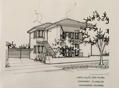
Drawing - Property Illustration, Margaret Picken, 1&2/70 Normanby Road, Kew, 2000
After training as a Cartographic Draftsman within the mining industry, I worked as a property illustrator for real estate firms in the eastern suburbs of Melbourne for 23 years from 1983. I initially photographed houses with a Polaroid camera and made a 'thumbnail' sketch while there. The photos were used to scale off a sketch in pencil and then that sketch was overlaid with drafting film and the 'pen and ink' completed. The pens I used were the Rotring ‘Rapidigraph’ drafting pens. The ink was also made by Rotring (German).The film was ‘Rapidraw’, polyester drafting film, double matte. It takes a very fine line and doesn’t bleed. As well as house sketches, there were often floor plans and site plans ordered. Aerial sketches were ordered when the property needed an overall view. (Margaret Picken, 2020)This drawing is one of a series created by Margaret Picken for a number of real estate agents in Melbourne between 1983 and 2005. Each work is signed and dated by the artist.Gift of Margaret Picken, 2020Pen and ink architectural drawing on drafting film of 1&2/112A Normanby Road, Kew by Margaret Picken.UNITS 1&2/70 HARP RD.[ actually 1&2/112A NORMANBY RD], KEW / MARGARET PICKEN 2000 / WOODARDS ~ HAWTHORNartist -- margaret picken 1950-, architectural drawings -- houses -- kew (vic.), 1&2/112a normanby road -- kew (vic.) -
Surrey Hills Historical Society Collection
Document, Copy of title, 391 Mont Albert Road, Surrey Hills
Victoria Melba Turner (known as Melba) and Elizabeth Maitland Anderson trained together at the Melbourne Hospital, completing their training just months apart; Melba in October 1914 and Elizabeth in May 1915. Both were registered on 31.3.1925 and listed at 391 Mont Albert Road, the site of Mosgiel Private Hospital. Note that the road was subsequently re-numbered and became 293 Mont Albert Road. 391 Mont Albert Road had previously been the home of the Sherar family and had originally been built for Charles J Currie, a solicitor. Three pages relating to the title of 391 Mont Albert Road. Historical search statement from Land Use Victoria is dated 15/09/2020. The reference is Vol 5414, Fol 1082747. 391 mont albert road, victoria melba turner, amy lillian hughes, muriel harper gilchrist, mosgiel hospital, 293 mont albert road, sherar family, charles j currie, quamby, elizabeth maitland anderson -
 Mont De Lancey
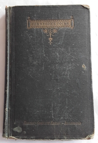
Book, Harper & Brothers, Tennyson's Poems
A Harper's Complete Illustrated collection of Tennyson's poems with Additional Poems at the back of the book.A damaged dark green fabric covered book of Tennyson's Poems with the title printed in gold in an elaborate decorative style at the top of the front cover. At the bottom written in gold lettering is Harper's Complete Edition - Illustrated. The spine has Tennyson's Poems in a gold lined rectangle at the top and Harper's at the bottom. Inside on the title page is printed - The Poetical Works of Alfred Tennyson Poet Laureate. Numerous illustrations, publisher details and 1871 with a head and shoulder black lined illustration of Tennyson. Opposite, the frontispiece shows an illustration of a man rowing a small boat past a castle on the hillside with a woman who has died lying in it shrouded by a lace coverlet.The Contents page lists his many varied works with a list of additional poems printed exclusively in this edition. At the back is a Harper Brothers' List of new Books, brief outlines of Draper's History of the American Civil War and Winchell's Sketches of Creation. p. 250.non-fictionA Harper's Complete Illustrated collection of Tennyson's poems with Additional Poems at the back of the book. poetry, alfred tennyson -
 Mont De Lancey
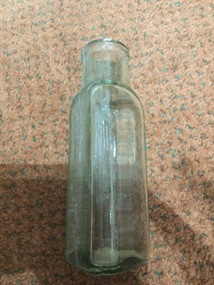
Container - Glass bottle
Small, triangular-shaped bottle filled with dark blue ink and with lettering down one side of the bottle. It has a small cork stopper.Down one side of the bottle: "R. HARPER & CO. Ltd" and on the base: "L 563"ink bottles, glassware -
 Mont De Lancey
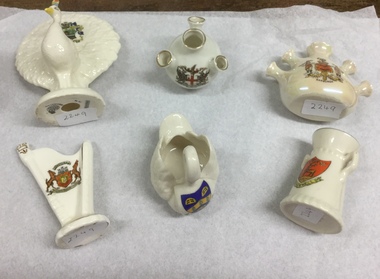
Ornaments
Six china items. 1. Porcelain urn made in England. Crest shows deer and bracknell. Has two handles. 7 cm. 2. Carlton china WNR. Stoke-on-Kent. Crest shows two men. "Fortis in Armis". Bamburgh. Has five prongs. 7 cm 3. Swan Royal ivory porcelain. England. Blue crest in Latin, with yellow and green leaves. Arms of Penshore Abbey. 8 cm. 4. Harp. Made in England. Florentine China. Has crest with horses. Writing in Latin. 10 cm. 5. Peacock. Crest St. John's Chapel. Weardale. Stoke-on-Trent. Arcadian. 12 cm 6. Four pronged vase. Made in Germany. Has crest with red cross and two dragons. London. 8 cmornaments -
 Mont De Lancey
Glass bottle, R. Harper & Co. Ltd
Glass bottleR. Harper & Co.bottles -
 Mont De Lancey
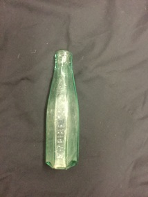
Glass bottle
6 sided glass bottle with a green tinge and several air bubble flaws in the glass.Empire Co. (x 2). Registered Robert Harper & Co. 9.2.91bottles, containers -
 Melbourne Tram Museum
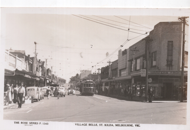
Postcard, Rose Stereograph Co, "Village Belle, St Kilda, Melbourne Vic", early 1950s
Rose Series postcard No. P 1343, titled "Village Belle, St Kilda, Melbourne Vic" showing W2 568 (Moreland Route 15) at the St Kilda Beach terminus in Ackland St. Another W2 is further behind. A uniformed tramway employee is walking across the road, underneath a MMTB sign advising of Trams to the City and a Fare of 5d and child fares of 2d. In the background is the Coles store and Harpers Frocks. In the foreground are tram tracks for the Victorian Railways St. Kilda to Brighton Beach line in Buckly Street.Yields information about Ackland St, St Kilda early 1950s.Postcard - printed real photograph with Rose Stereograph Co. name on the rear.trams, tramways, village belle, ackland st, route 15, st kilda, w2 class, tram 568 -
 Vision Australia
Photograph - Image, Ferguson and Urie stained glass window, 1868
During the construction of the St Kilda Road building for the Asylum and School for the Blind (later known as the Royal Victorian Institute for the Blind), the Melbourne firm of Ferguson and Urie were commissioned to create a stained glass window for the main staircase. This consisted of six panes, with a different emblem in each: three yellow lions (Royal Coat of Arms), a harp with a figurehead (Kingdom of Ireland), a red lion (Wales), a Tudor rose (England), a shamrock (Ireland) and a thistle (Scotland).3 col. images of stained glass window in St Kilda Road buildingferguson and urie, royal victorian institute for the blind -
 Damascus College
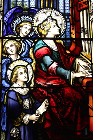
Artwork, other - Kathleen Meagan Memorial Window
Kathleen Meagan was placed in the Ballarat Convent of Mercy as an infant. She remained there throughout her life until she died at age 34. Her friendly, cheerful personality in the face of ill health meant that she was cherished by all who knew her. Her talents on the violin, harp, piano and cello were outstanding, and she was beloved by the Sisters of Mercy and the students of Sacred Heart College. This memorial window depicting Saint Cecilia at the organ was commissioned upon her passing in 1925, and was installed in the SHC chapel and blessed by the Bishop in 1926.Stained glass window constructed in 1926 To the memory of Kathleen Blanche Meagan RIPsisters of mercy, ballarat musicians, herr goll -
 Eltham District Historical Society Inc
Photograph - Digital Photograph, Marguerite Marshall, Jesse Tree playing the Didgeridoo and Swiss Hang Drum at St Andrews Market, 29 March 2008
Published: Nillumbik Now and Then / Marguerite Marshall 2008; photographs Alan King with Marguerite Marshall.; p175 It’s Saturday morning and thousands of people are visiting St Andrews Market at the corner of Heidelberg-Kinglake Road and Proctor Street. It’s hard to find a park. Cars are banked up along the narrow road and crammed in a nearby parking area. Yet, at the market, people look relaxed and happy amongst the yellow box gums on the site where the Wurundjeri people used to gather. Stone artefacts unearthed there by Koorie researcher, Isabel Ellender, indicate the site was once a Wurundjeri meeting place, according to Aboriginal Affairs Victoria. Acoustic sounds mingle with quiet conversations. A guitarist blows a mouth organ while his bare toes tickle chimes. A tiny busker, perhaps five years old, plays a violin while sounds of a harp emerge from the hall. One stallholder, selling delicious-looking pastries, chats to another in Spanish, then to me in broad Australian. ‘I was born in Fitzroy but my mother came from Mexico and my dad from Serbia,’ she smiles. A New Zealander fell in love with Mongolia and now imports their hand-made embroidered clothes and Yurts (tents) and runs adventure tours. A young woman visited Morocco and when friends admired the shoes she bought, she decided to import them and sell them at the market. Oxfam sells Fair Trade toys and clothes and displays a petition to Make Poverty History. Other stalls sell Himalayan salt, jewellery made from seeds from northern Australia, glass paper-weights from China as well as locally grown vegetables, flowers and organic freshly baked bread. A woman sits in a state of bliss under the hands of a masseur. Another offers Reiki or spiritual healing. A juggler tosses devil sticks – ‘not really about the devil,’ he smiles. This skill was practised thousands of years ago in Egypt and South America he says. At the Chai Tent people lounge on cushions in leisurely conversation. The idea for the market was first mooted among friends over a meal at the home of famous jazz and gospel singer Judy Jacques.2 Jacques remembers a discussion with several local artists including Marlene Pugh, Eric Beach, Les Kossatz, Ray Newell and Peter Wallace. ‘We decided we wanted a meeting place, where all the different factions of locals could meet on common ground, sell their goodies and get to know one another,’ Jacques recalls. They chose the site opposite another meeting place, St Andrews Pub. A week later Jacques rode her horse around the district and encouraged her neighbours to come along to the site to buy or sell. On February 23, 1973, about 20 stallholders arrived with tables. They traded ‘second-hand clothes, vegetables, meat, cheese, eggs, chickens, goats, scones, tea, garden pots and peacock feathers’. Now around 2000 people visit each Saturday. People usually linger until dusk. The market – with around 150 stalls of wares from a wide variety of cultures – stands alongside Montsalvat as the most popular tourist attraction in Nillumbik. By the 1990s St Andrews Market was in danger of being loved to death, as the site was becoming seriously degraded. The market was spreading in all directions and the degradation with it. A local council arborist’s report in 1994 noted exposed tree roots from erosion and compaction. The Department of Sustainability and Environment threatened to close the market if the degradation was not rectified. After many months of research, discussions and lobbying by a few residents, the council formed a Committee of Management, with an Advisory Committee, and introduced an Environment Levy. The State Government, the council and the market, funded terracing of the site to stop erosion, and retain moisture and nutrients. Vehicles were excluded from some sensitive areas and other crucial zones reserved for re-vegetation. Volunteers planted more than 3000 locally grown indigenous species. The old Yellow Box trees fully recovered and are expected to give shade for many years to come.This collection of almost 130 photos about places and people within the Shire of Nillumbik, an urban and rural municipality in Melbourne's north, contributes to an understanding of the history of the Shire. Published in 2008 immediately prior to the Black Saturday bushfires of February 7, 2009, it documents sites that were impacted, and in some cases destroyed by the fires. It includes photographs taken especially for the publication, creating a unique time capsule representing the Shire in the early 21st century. It remains the most recent comprehenesive publication devoted to the Shire's history connecting local residents to the past. nillumbik now and then (marshall-king) collection, didgeridoo, jesse tree, st andrews market, swiss hang drum -
 Melbourne Tram Museum
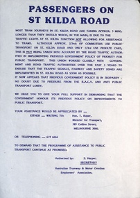
Document - Notice, Australian Tramway & Motor Omnibus Employees Association (ATMOEA), "Passengers on St Kilda Road", c1985
... Notice or circular - titled "Passengers on St Kilda Road...Notice or circular - titled "Passengers on St Kilda Road ...Notice or circular - titled "Passengers on St Kilda Road", authorised by J Harper, Secretary of the Australian Tramway & Motor Omnibus Association (ATMOEA), about tram priority at St Kilda Junction, asking tram passengers to write to Tom Roper, Minister for Transport seeking action to improve traffic signals. Tom Roper was Minister for Transport from 1985 to 1987.Demonstrates the Union's work on tram priority.Notice - A4 sheet printed with dark blue ink.tramways, traffic signals, st kilda junction, unions, tom roper, atmoea, j harper