Showing 161 items
matching highett road
-
 City of Moorabbin Historical Society (Operating the Box Cottage Museum)
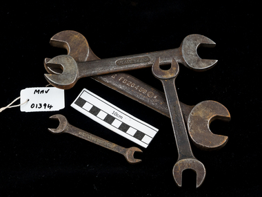
Tools, Spanners graduated Large x4 c1950, c1950
. Early settlers were self reliant and repaired their own equipment for kitchen,dairy, farm, horses, carts using various tools . With the advent of motorized vehicles in 20thC residents of the City of Moorabbin became accustomed to maintaining their own cars and trucksThese large graduated spanners are typical of the type used by residents and mechanics in the City of Moorabbin c19504 x Large graduated automobile Spanners c1950 a, b Snail Brand; c Husky England; d The Superwrenchspanners, motor cars , motor trucks, mechanics, automobiles, early settlers, market gardeners, blacksmiths, tools, building equipment, hammers, moorabbin shire, bentleigh, mckinnon, highett, cheltenham,mcewan james pty ltd, melbourne, bunnings pty ltd, -
 City of Moorabbin Historical Society (Operating the Box Cottage Museum)
Tools, Rule, 12-24 inch folding, graduated steel, 20thC
Tools, Rule, 12-24 inch folding,steel used by builders and mechanics in City of Moorabbin 20thC This large graduated steel ruler is typical of the type used by residents in the City of Moorabbin 20thCTools, Rule, 12-24 inch folding, graduated, steel rulers, measures, set squares, trigonometry, early settlers, market gardeners, blacksmiths, tools, building equipment, hammers, moorabbin shire, bentleigh, mckinnon, highett, cheltenham,mcewan james pty ltd, melbourne, bunnings pty ltd, -
 City of Moorabbin Historical Society (Operating the Box Cottage Museum)
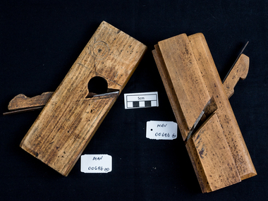
Tool - Wood Planes, handmade c1880, c1880
Early settlers in Moorabbin Shire were self reliant and made and repaired their own equipment for kitchen,dairy, farm, horses, carts using various tools . Among the early settlers were blacksmiths who made tools for the other settlers who were establishing the homes, market gardens, farms, orchards and various businesses. These wood planes are typical of the type made and used by early settlers in Moorabbin Shire c18802 handmade wood planes with blades. b) has 3cm groove for molding wood planes, spanners, early settlers, market gardeners, builders, blacksmiths, tools, building equipment, hammers, moorabbin shire, bentleigh, mckinnon, highett, cheltenham, mcewan james pty ltd, melbourne, bunnings pty ltd -
 City of Moorabbin Historical Society (Operating the Box Cottage Museum)
Functional object - Australia Post Bag x 2, Australia Post, mid 20th Century
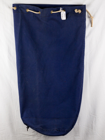
2 blue canvas Australia Post bags with brass eyelets used mid 20th Century to deliver mail to householders in the City of Moorabbin . Small bag has Australia Post Stamped on it and the large bag has no markings but has white rope threaded through the brass eyeletsAustralia Post Canvas Bags donated by Judy Clark the daughter of George Reed who lived and worked in the City of Moorabbin in 20th century 2 Blue canvas bags with brass eyeletsa) AUSTRALIA POST OFFICE 869 No 5 b) no marking ; white rope australia post, post offices, mail, bentleigh, moorabbin, mckinnon, ormond, cheltenham, highett, early settlers, reed george -
City of Moorabbin Historical Society (Operating the Box Cottage Museum)
Tool - Tools 'Atlas' spray gun
A mid 20th Century Atlas PTY Ltd Spray Painting kit This tool is typical of the type used by early settlers in Moorabbin mid 20th century Tools atlas spray painting gun Atlas Pty Ltd early settlers, market gardeners, blacksmiths, tools, building equipment, hammers, moorabbin shire, bentleigh, mckinnon, highett, cheltenham, mcewan james pty ltd, melbourne, bunnings pty ltd -
 City of Moorabbin Historical Society (Operating the Box Cottage Museum)
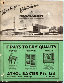
Magazine - Where to go .. Who to know .. in City of Moorabbin, Metropolitan Business Directories, Bentleigh, Ormond, McKinnon, Cheltenham, Highett, Moorabbin and East Bentleigh, 1962
A booklet printed for the residents of the City of Moorabbin to acquaint them with the many amentities and services, as well as the employment opportunities, available close to their own homes. Booklet contains useful information about the City of Moorabbin, the services provided in the area, advertisements for local businesses, index of street names, Maps and more....Information booklet provided for the residents in the City of MoorabbinInformation booklet - 88 pagesbusiness, maps, city of moorabbin, bentleigh, ormond, mckinnon, cheltenham, highett, moorabbin, east bentleigh -
 City of Moorabbin Historical Society (Operating the Box Cottage Museum)
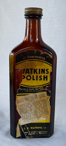
Domestic object - Watkins Polish, J. R. Watkins Co (USA), 20thC
The J. R. Watkins Co. opened its first overseas branch in Australia in 1935. The J. R. Watkins built a large factory at Highett on a six acres on the east side of Nepean Highway (no. 1123) in 1954. The J. R. Watkins company was founded in 1868 in Plainview, Minnesota USA, moving to Winona in 1885, by J. R. Watkins.Example of industry in the City of Moorabbin.Amber glass bottle with a metal screw on lid. A paper label is on the front of the bottle 'Watkins Polish" printed in yellow, black and white.PRINTED ON LABEL: 11 Fluid ounces - WATKINS POLISH - Gives a hard dry lustre excellent for Dusting For cleaning, dusting and polishing furniture, pianos, woodwork, linoleum, hardwood floors and all polished surfaces. Directions: If the article to be polished is dirty or gummy, clean it by washing with mild soap and warm water. Apply Watkins Polish with a damp, soft cloth (Dampened with water and wrung almost dry). The Polish may be poured on the damp cloth or on the surface to be polished. In either case rub it all with a dry cloth to obtain a high polish. When dusting, dampen the cloth with Watkins Polish - it keeps down the dust and gives a lustre which is neither greasy not gummy. The J. R. Watkins Co. Melbourne - Sydney - Adelaide - Kogarah EMBOSED ON BOTTLE: "The J.R.Watkins co. Made in Australia" the j. r. watkins co, highett, polish -
 City of Moorabbin Historical Society (Operating the Box Cottage Museum)
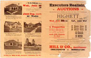
Flyer - Executors Realising Auction for land in Highett, 1941
The Great Depression of Australia halted the sale of land in most circumstances - this sale was just after the end of the depression years of 1930 to 1939.Example of the progress of the Municipality of MoorabbinAdvertising flyer for auction of real estate sales - plan of building blocks for saleSale of land in Highett - Hill & Co (A. W. Hill, Auctioneer) - brochure has pictures of the houses on the properties being offered for saleviola crescent, wickham road, henry street, real estate, highett, moorabbin, auctions, benjamin lowden -
 City of Moorabbin Historical Society (Operating the Box Cottage Museum)
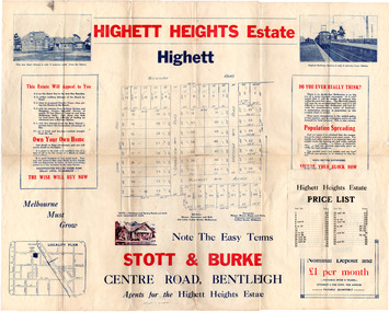
Flyer - Highett Heights Estate, Highett
... (now Seaton Road) Maroona Road Spring Road Real Estate Highett ...Land sales in the Municipality of Moorabbin increased when the train line from the City to Frankston was electrified.Example of the progress of the Municipality of MoorabbinAdvertising flyer for auction of real estate sales - plan of building blocks for saleHighett Heights Estate, Highett - Stott & Bourke 58 home siteswickham road, hillcrest avenue, grandview road (now seaton road), maroona road, spring road, real estate, highett, moorabbin -
 City of Moorabbin Historical Society (Operating the Box Cottage Museum)
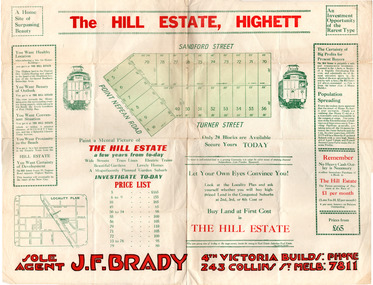
Flyer - Hill Estate, Highett
Land sales in the Municipality of Moorabbin increased when the train line from the City to Frankston was electrified.Example of the progress of the Municipality of MoorabbinAdvertising flyer for auction of real estate sales - plan of building blocks for saleThe Hill Estate, Highett - 24 Housing Blocks - J. F. Bradypoint nepean road (nepean highway), turner street, sanford street, real estate, highett -
 City of Moorabbin Historical Society (Operating the Box Cottage Museum)
Flyer - The Hill Estate, Highett, 1917
The land sales in the area stopped due to the 1890s depression. For the next 20 years real estate sales virtually stopped until after WWI.Example of the progress of the Municipality of MoorabbinAdvertising flyer for auction of real estate sales - plan of building blocks for saleThe Hill Estate, Highett - 110 allotments - Auction Saturday September 22, 1917 T.R.B. Morton & Sonpoint nepean road (nepean highway), turner street, sanford street, alfred street, peace street, highett, real estate, moorabbin -
 City of Moorabbin Historical Society (Operating the Box Cottage Museum)
Flyer - Warwick Estate, Highett
... Cottage Museum) Joyce Park Jasper Road Ormond melbourne The train ...The train line from the city to Frankston was electrified in 1922 which intensified the sale in the municipality of Moorabbin, particularly land which was in the vicinity of the railway stations.Example of the progress of the Municipality of MoorabbinAdvertising flyer for sale of real estate sales - plan of building blocks for saleWarwick Estate Highett, 23 housing blocks - Frank J. Harriswickham road, herbert street, highett, real estate -
 City of Moorabbin Historical Society (Operating the Box Cottage Museum)
Flyer - Gun Club Estate, Highett, 1927
The train line from the city to Frankston was electrified in 1922 which intensified the sale in the municipality of Moorabbin, particularly land which was in the vicinity of the railway stations. York Investments Pty Ltd purchased the land in 1927.Example of the progress of the Municipality of MoorabbinAdvertising flyer for auction of real estate sales - plan of building blocks for saleGun Club Estate, Bentleigh 76 housing blocks - York Investments Pty Ltdthomas street, erica avenue, brewer road, grace street, victor road, melbourne gun club, benteligh, real estate -
 City of Moorabbin Historical Society (Operating the Box Cottage Museum)
Flyer - O'Donovan's Estate, Highett
At the end of World War One, there was a renewed interest in residential land and a number of estates opened up in the Municipality of Moorabbin.Example of the progress of the Municipality of MoorabbinAdvertising flyer for auction of real estate sales - plan of building blocks for saleO'Donovan's Estate Highett - 180 blocksjames ave, clonmult ave, desmond av, mary av, bay road, cloyne street, middleton st, real estate, highett -
 City of Moorabbin Historical Society (Operating the Box Cottage Museum)
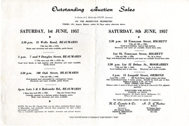
Flyer - Outstanding Auction Sales, 1957
Sale of property of the estate of Charles McCarthy Stott, a local estate agent. Example of the progress of the Municipality of MoorabbinAdvertising flyer for outstanding Auction Sales in the estate of Charles McCarthy Stott (1870-1956).Saturday 1 June 1957 - 4 properties for sale in Beaumaris - Saturday 8 June 1957 - 4 properties for sale in Highett (x2), Moorabbin, Ormondormond, 33 wells road beaumaris, 7 & 9 douglas street beaumaris, 100 oak street beaumaris, 5 & 6 balcombe road beaumaris, 34 tennyson street highett, 13 leopold st ormond, lot 93 tennyson street highett, lot 52 delma st moorabbin, auction, real estate -
 City of Moorabbin Historical Society (Operating the Box Cottage Museum)
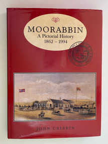
Book, Cribbin, John, Moorabbin : a pictorial history 1862-1994, 1995
Moorabbin: A Pictorial History is about a city that was. The book traces the story of Moorabbin for its beginnings to its end in 1994, from inside coverix, 214 p. : col. ill., ports.non-fiction Moorabbin: A Pictorial History is about a city that was. The book traces the story of Moorabbin for its beginnings to its end in 1994, from inside covermoorabbin, city of moorabbin, mckinnon, ormond south, benteligh, bentleigh east, heatherton, oakleigh south, highett, cheltenham -
 City of Moorabbin Historical Society (Operating the Box Cottage Museum)
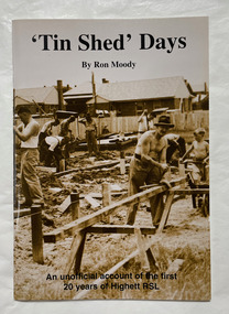
Book, Moody, Ron, 'Tin shed' days, 1997
... Cottage Museum) Joyce Park Jasper Road Ormond melbourne Highett ...An unofficial account of the first 20 years of Highett RSL.44 p. : plans, ports. ;non-fictionAn unofficial account of the first 20 years of Highett RSL.highett, highett rsl, returned services league of australia -
 Bayside Gallery - Bayside City Council Art & Heritage Collection
Map, Department of Crown Lands and Survey et al, Moorabbin, County of Bourke, Government Roads, 1920
The cadastral map of the Parish of Moorabbin in Victoria (L.6104) shows parish boundaries and land ownership 1920 when Sandringham was a Town. The government roads have been coloured in red pencil.moorabbin, county of bourke, map, plan, land subdivision, land titles, foreshores, hampton, beaumaris, highett, cheltenham, department of lands and survey, land owners, cartographic material, brighton, sandringham, town of sandringham, government roads -
 Bayside Gallery - Bayside City Council Art & Heritage Collection
Map, Department of Crown Lands and Survey, Moorabbin, County of Bourke, c. 1918
The cadastral map of the Parish of Moorabbin in Victoria (L.6104) shows parish boundaries and land ownership c. 1918 when Sandringham was a Borough.moorabbin, county of bourke, map, plan, land subdivision, land titles, foreshores, sndringham, hampton, beaumaris, highett, cheltenham, department of lands and survey, land owners, cartographic material, borough of sandringham, brighton -
 Clayton RSL Sub Branch
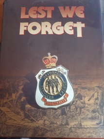
hard cover non-fiction book, Weldon-Hardie, Lest we Forget, 1986
History of the Returned & Services League 1916-1986hard cover non fiction bookStamped " Highett Returned & Services Club, 1 Station St, Highett. -
 City of Kingston
Photograph - Black and white, c. 1960
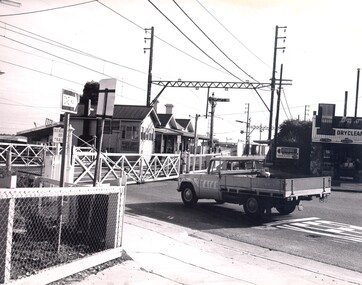
... City of Kingston Parkdale Library 96 Parkers Road, Parkdale ...Highett railway station with crossing gates closed and traffic waiting.Black and white photograph of Highett railway gates. Gates are closed and a ute is waiting at the crossing.Stamped on reverse: COPYRIGHT / Public Transport Corporation / For re-ordering photographs / Please quote negative No H3985 / Enquiries C/- PIC Photographic Unit / Telephone switchboard 519 1111highett, city of kingston, level crossing, railway station -
 City of Kingston
Photograph - Black and white, c. 1960
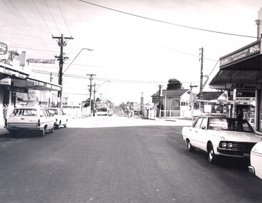
This image is part of a larger collection of images from the Public Transport Corporation displaying train stations and streetscapes in what is now the City of Kingston.Black and white photograph depicting the level crossing at Highett, with the shopping street visible in the foreground. There are several cars parked on both sides of the road and a bus has just crossed the crossing (on the left hand side).Stamped in blue ink on reverse: COPYRIGHT / Public Transport Corporation / For re-ordering photographs / Please quote negative No H3983 / Enquiries C/- PTC Photographic Unit / Telephone switchboard 619 111highett, railway station, suburbs, streetscape -
 City of Kingston
Photograph - Black and white, c. 1950
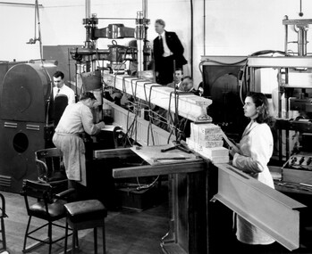
CSIRO, the Commonwealth Scientific and Industrial Research Organisation, moved into a former RAAF factory in Highett in the post-war years. CSIRO closed down the Highett facility and sold it in 2011.Black and white photograph of workers at CSIRO (Commonwealth Scientific and Industrial Research Organisation) complex in Highett. In this image, building materials are being tested. In the foreground is physicist Valerie Goullet, standing top centre is Dr Keith Martin both CSIRO Division of Building Research.Small white sticker adhered to reverse of image with printed black text: 206 Handwritten in red ink on reverse of image: 53%science, highett, workers, industry -
 City of Kingston
Photograph - Black and white, c. 1950
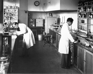
CSIRO, the Commonwealth Scientific and Industrial Research Organisation, moved into a former RAAF factory in Highett in the post-war years. CSIRO closed down the Highett facility and sold it in 2011.Black and white photograph of workers at the CSIRO (Commonwealth Science and Industrial Research Organisation) facility in Highett.Small white circular sticker with black printed text: 205 Handwritten in red ink: 55%science, highett, workers, industry -
 City of Kingston
Photograph - Black and white, 20 December 1945
Cheltenham is a suburb in the City of Kingston that was originally established as a rural market gardening community. The area is bordered by Highett, Mentone and Heatherton. The market gardens, farms and paddocks have gradually been sub-divided into housing and industrial estates. The Southland shopping centre is a major feature of the area.Cheltenham was established as a rural market gardening community. The Le Page family lived in Cheltenham since 1854 when Nicholas Le Page, a tailor from the Channel Island of Guernsey, bought two acres of land on Chesterville Road near Bernard Street to establish a market garden. Over the years the Le Pages purchased more land in the area. In 1875-76 Nicholas' son Frank and his wife Mary built 'Daphne Cottage' near the corner of Bernard and Wilson Streets. n the 1940s Frank's son, Everest Le Page, bought five more lots of land in Chesterville Road from the Tuck family. The Le Pages grazed horses, ponies and cows on this land, and grew pumpkins, carrots, parsnips, onions, potatoes and cabbages. Many buildings and locations within in Cheltenham commemorate the Le Page family's contribution to the Cheltenham community.Aerial photograph taken in 1945 of the Cheltenham district within the City of Kingston. The image includes Chesterville Road, the future site of Turner Road pool (now Waves) and Highett Reserve, (top left), Jellicoe Street, Argus Street, Bernard Street, Wilson Street, the Methodist Children Homes (now Southland), McIvor Street, Goulburn Street, Nepean Highway, Jamieson Street and Barker Street (bottom left), market gardens and paddocks. In the top centre of the image, "Daphne Cottage", the home of Frank T. Le Page is visible on the corner of Bernard and Wilson Streets. Much of the land depicted in this image was owned by the Le Page family. This image is possibly from the collection of aerial photographs commissioned by the Department of Crown Lands and Survey and taken by Adastra Airways.Black and white ink: 57250 White print: VIC-170 57250 20.12.45 Run 6 PROJ. No. 5 MELB. METROP AREA Black type 10200 FTS 30' LENS 20.12.45cheltenham, market gardens, industry, le page family -
 City of Kingston
Photograph - Black and white, 20 December 1945
This aerial photograph depicts the changing landscape of Cheltenham and Highett since WWII. Photographed in 1945, there is a mix of urban dwellings and industrial development and precedes the major transformation of Cheltenham with the development of the Southland shopping centre in the 1960s and expansion in the 1990s.A large part of Cheltenham was originally established as a rural market gardening community. The railway line and station brought urban development to the area and in the north, the Highett area was dominated by the Highett Gas Works. Cheltenham became a major destination for shopping in the 1960s with the opening of Southland.Aerial photograph taken in 1945 of Cheltenham and Highett within the City of Kingston. The image includes the Highett Reserve, (top right), the Methodist Children Homes (now Southland), Nepean Highway and Jamieson Street. Highett Gas Works is visible in the top left and the land now named William Fry Reserve at the intersection of Bay Road and Nepean Highway. A visible large parcel of land on the corner of Bay Road and Nepean Highway was developed in the 1990s as the west side addition to Southland. The densely vegetated area in the upper right sector of the image is now dense with housing. Tulip Grove, Heather Grove and Gilford Street are visible bottom left. This image is possibly from the collection of aerial photographs commissioned by the Department of Crown Lands and Survey and taken by Adastra Airways.Black ink: 57252 White lettering: VIC-10 57252 20.12.45 [lens information indecipherable] PROJ. No.5 MELB. METROP AREA Black pencil: 80highett, cheltenham, highett gas works, urbanisation -
 City of Kingston
Photograph - Black and white, 20 December 1945
This aerial photograph depicts the changing landscape of Cheltenham and Highett since WWII. Photographed in 1945, there is a mix of urban dwellings and industrial development and precedes the major transformation of Cheltenham with the development of the Southland shopping centre in the 1960s and expansion in the 1990s.A large part of Cheltenham was originally established as a rural market gardening community. The railway line and station brought urban development to the area and in the north, the Highett area was dominated by the Highett Gas Works. Cheltenham became a major destination for shopping in the 1960s with the opening of Southland.Aerial photograph taken in 1945 of Cheltenham and Highett within the City of Kingston. The image includes the Highett Reserve, (top right), the Methodist Children Homes (now Southland), Nepean Highway and Jamieson Street. Highett Gas Works is visible in the top left and the land now named William Fry Reserve at the intersection of Bay Road and Nepean Highway. A visible large parcel of land on the corner of Bay Road and Nepean Highway was developed in the 1990s as the west side addition to Southland. The densely vegetated area in the upper right sector of the image is now dense with housing. Tulip Grove, Heather Grove and Gilford Street are visible bottom left. This image is possibly from the collection of aerial photographs commissioned by the Department of Crown Lands and Survey and taken by Adastra Airways.Black type: Reverse lettering VIC-10 57252 20.12.45 [lens information indecipherable] PROJ. No.5 MELB. METROP AREA White lettering: Reverse writing 57252cheltenham, highett, highett gas works, urbanisation -
City of Kingston
Photograph - Black and white, 5 January 1984
... and Highett within the City of Kingston. The area depicted in the 1984...City of Kingston Parkdale Library 96 Parkers Road, Parkdale ...Moorabbin, Cheltenham and Highett are suburbs in the City of Kingston with a diverse mix of development and zoning. The market gardens, farms and paddocks have gradually been sub-divided into housing and industrial estates and associated infrastructure such as schools and shopping facilities. The area includes many parks, reserves and golf courses.This aerial image covers a diverse section of the City of Kingston, taking in the suburbs of Cheltenham, Moorabbin, Beaumaris and Highett. By 1984, the market gardens of the district have been replaced by housing and factories. The Gas and Fuel state-of-the-art Scientific Services Department is visible on Nepean Highway Highett. The CSIRO Highett site can also be seen. Both sites have now been demolished and have undergone remediation. The Southland site is visible and yet to be redeveloped by Westfield. This image portrays the diversity of development in the City of Kingston with a mixture of green spaces, housing and commercial and industrial features.Aerial photograph of Cheltenham, Beaumaris, Moorabbin and Highett within the City of Kingston. The area depicted in the 1984 aerial view includes Eden Street and Edward Street, Cheltenham (top left), Weatherall Road and Reserve Road, Cheltenham/Beaumaris (top right), Turner Road and Chesterville Road, Moorabbin (bottom left), Nepean Highway (left section), Graham Road and Middleton Street, Highett (bottom right). A large section of this image includes Cheltenham Park and Victoria Golf Club.White text: 3831-219 Lens information [indecipherable] RINGWOOD M/S 7922-3 RUN 15 Clockface image 5,300' ASL VIC DLS© 5-1-84cheltenham, highett, industrialisation, urbanisation, moorabbin, beaumaris -
City of Kingston
Photograph - Black and white, 3 March 1954
Cheltenham and Moorabbin are suburbs within the City of Kingston that were originally established as rural market gardening communities The area is bordered by Highett and Mentone. The market gardens, farms and paddocks have gradually been sub-divided into housing and industrial estates. Highett is developed with residential homes but was also the site of major facilities such as the Highett Gas Works. This aerial image covers a diverse section of the City of Kingston, taking in the suburbs of Moorabbin, Cheltenham, Highett and Mentone Residential housing development is prominent along the Frankston Railway line and the area still retains extensive market gardens and paddocks yet to be converted to a large industrial and commercial zone.Aerial photograph of Mentone, Cheltenham and Moorabbin within the City of Kingston. The area depicted in this 1954 aerial view includes Warrigal Road and Centre Dandenong Road intersection (top left); Charman Road, Patty Street, Bourke Street, Collins Street Mentone (top right); Keys Road Moorabbin (bottom left); Bay Road, Cheltenham (bottom right), Friendship Square, Cheltenham Park, Victoria Golf Club and Jack Barker Oval are visible. Nepean Highway and the Frankston railway line run centrally through the image. Highett Gasworks is also evident.White handwriting and type [indecipherable]. White image of clockface White image of compass White type 42956 Black handwriting 3/3/54 Williams [indecipherable] Black pencil: S [arrow] Black ink: 3/3/1954cheltenham, moorabbin, mentone, highett, market gardens -
City of Kingston
Photograph - Black and white, 27 February 1964
Cheltenham is a suburb in the City of Kingston that was originally established as a rural market gardening community. The area is bordered by Highett. The previous market gardens, farms and paddocks have gradually been sub-divided into housing and industrial estates. The Methodist Children's Home Methodist Homes for Children and St John of God Training Centre on the site of the future Southland shopping centre has not yet been demolished. The recently built Cheltenham High School is visible and the increased urbansation of the area is evident. Some farmland remains including the Le Page homestead.The developing urban area of Cheltenham within the City of Kingston. This image illustrates the mid-century urban sprawl of of Cheltenham and the subdivision of market gardens within the municipality and the changing demographic of the district as new houses are constructed and infrastructure established.Aerial photograph of the suburbs of Cheltenham and Highett within the City of Kingston. Highett Gas Works (top left); Bernard Street, Cheltenham (top right); Weatherall Road (bottom left): Elliott and Cobham Streets Cheltenham (bottom right).White handwritten: X Vic.1831 White type: MELBOURNE 1963 PROJECT RUN23 [underlined] 27-2-64 LENS 205 152-70 M/M 5.150 [arrow] White handwritten: X 166 cheltenham, highett, urbanisation