Showing 207 items matching "hill residence"
-
 Ballarat Heritage Services
Photograph - Photograph - Colour, Dorothy Wickham, Ballarat Female Refuge, 2000
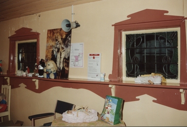
Ballarat Female Refuge was established in 1867 by a group of 26 Ballarat ladies. It was moved to the present site in Scott's Parade in 1884. It is now a private residence.Postcard size colour photgraphs showing the interior and exterior of the Ballarat Female Refuge. ballarat femail refuge, welfare, town and city mission, alexandra babies home, baby, orphanage, sarah ellis -
 Ballarat Heritage Services
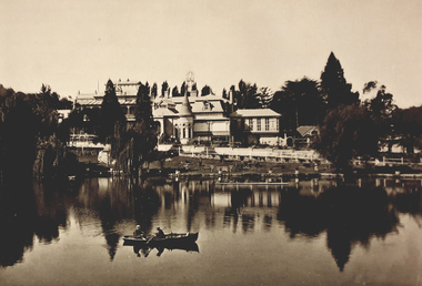
Photograph - Image - Black and White, "Fortuna" Bendigo, The Residence of Mrs George Lansell, c1918, c1918
Fortuna is the goddess of fortune and the personification of luck. Fortuna Villa is a magnificent house built by George Lansell it was kept secure for many years while use by the Defence Department. tour this magnificent home.Fortuna in Bendigo.george lansell, bendigo, fortuna -
 Ballarat Heritage Services
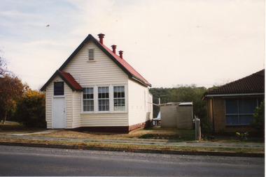
Photograph - Photograph - Colour, Clare Gervasoni, Former Yandoit Hills School 2052 after being moved to Hepburn Springs, c2005, c2005
... Ballarat Heritage Services PO Box 2209 Bakery Hill Post ...This building was moved from Yandoit Creek to the corner of Main Road and Seventh Street, Hepburn Springs. Colour photograph of on old schoolhouse that was moved from Yandoit Hills to the corner of Main Road and Seventh Street, Hepburn Springs. The building was used for religious services before being turned into a private residence. yandoit hills state school no 2052, education, hepburn springs, yandoit hills, yandoit creek -
 Old Colonists' Association of Ballarat Inc.
Document, Gerald Jenzen, Henry Hannington
Biography of Henry Hannington who was born in County Tyrone, Northern Ireland on 17 March 1819 and died in Ballarat at his residence in Crompton Street, Soldiers Hill on 1 January 1893 aged 73 years. Henry married Jane Crabb in the Independent Church in Melbourne in 1853. Jane died in Ballarat on the 23 January 1887,. Henry Hannington had various occupations including Shepherd, Miner, Trooper and Bricklayer. He was also listed as a Ballarat Pioneer who was resident in the District before the first Gold Licence was issued on 20 September 1851.Document on the history of early member of the Old Colonists' Association, Henry Haningtonhenry hannington, old colonists' association ballarat, ballarat old colonists' club, jane hannington -
 Old Colonists' Association of Ballarat Inc.
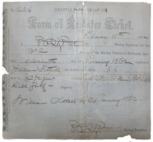
Document, Form of Register Ticket made out to William Fittall, 1862
Small ticket stub for a Form of Register TicketForm of Register Ticket No. 224 Schedule XXVII By Law XIII February 11th 1862 I, P.P.FitzPatrick Mining Registrar for the No 2 division of the Mining District of Ballaarat, have this eleventh day pf February 1862 registered Willia Fittall for a residence claim, 66 feet by 82 1/2 feet situated east of Peel Steeet near Black Hill Gully (signed) William Fittall on 28 January 1862sailor, immigration, thomas paterson, greenock, george dempster, chevalier -
 Mt Dandenong & District Historical Society Inc.
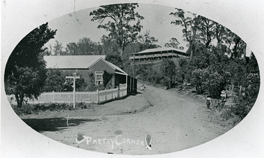
Photograph, 'Pretty Corner' FiveWays c1911
Oval photo, landscape view. Mountjoy on hill. Side view of the Post Office with residence showing the fence and a sign. Two children on Ridge Road and two girls outside the Methodist Church, which is not in view.post office, pretty corner, mountjoy, ridge road, fiveways -
 Melbourne Legacy
Document, Proposals from J.L.C, 1942
Notes from the meeting of the Junior Legatee Committee held on 28 September 1942 reveal how Legatees perceived the need to establish a residence for juniors. The notes detail the type of residence which would be appropriate, and how it should be funded and run in broad outline. These views were informed by an interview with the Headmaster of Box Hill Grammar School, a co-educational boarding school.It is interesting to note the different attitudes towards boys and girls at that time; girls required sewing and music rooms to replace the workshop and gym for the boys. The impetus to provide safe accommodation for children exemplify Legacy values.5 quarto carbon copies, black on white, two punched holes for filing.Pages 4 and 5 hand written numbers '4' and '3' Date on Page 1 underlined in pen.holmbush initial negotiations, committee -
 Otway Districts Historical Society
Ledger, B.R. Gowan & Co, Lavers Hill Cheese Factory, 1910-1913, 1910-13
Lavers Hill Cheese Factory operated from 1906 until about August 1913. It consisted of a factory and a residence, with the managers B. Philbrick, D. McRae and D. McDonald. The ledger, covering the period 1910 until 1913 when the factory closed, deals with cheese sales, local sales, milk purchases and journal entries for this period, as well as wages, cartage and other operating expenditure. The Lavers Hill Cheese Factory closed when it became more advantageous to send their cream into Colac. Ledger. Lavers Hill Cheese Factory, 1910-1913.Loose leaf: Lavers Hill Cheese Factory; Purchases Butterfat, 1910-11; contents; Manufacturing A/c.lavers hill; cheese; factory; butter; -
 Otway Districts Historical Society
Photograph, Crowes: Terminus of the railway line, 1911
The terminus of the railway, and the southern-most station on the Australian mainland, was Crowes, approximately 2 kilometres from Lavers Hill. The line ended at "The Black Stump". Crowes was designed as a fully functioning terminus and received a complete instalment of facilities. The site was laid out with three roads plus a dead end siding for a locomotive shed and ash pit. Goods sheds, a platform and livestock ramps catered for freight loadings, while on the north side was a station office, waiting room, parcels shed and passenger shelter. Three departmental residences were also provided. The resident Station Master was withdrawn in November 1916 and the station closed with the line on 10 December 1954.Photograph. Terminus of the Colac-Crowes at Crowes.crowes; terminus; "the black stump"; -
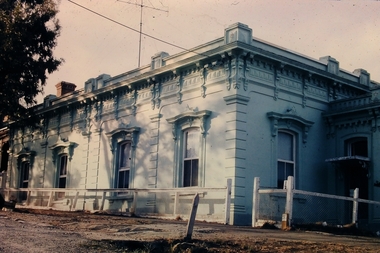 Bendigo Historical Society Inc.
Slide - Osborne House 33 MacKenzie Street Bendigo
The Bendigo & Region Branch is the National Trust’s voice in the region. The Branch works with council and the community on local heritage issues. New members are always welcome at any of the Branch’s meetings and events. Designed by renown Bendigo architects Vahland and Getzschmann, Osborne House was originally built as a private school in 1869, extended in 1870 and sold in 1888 when it became a boarding house. The property enjoys a privileged position surrounded by more of Vahland's inspiring designs - the Forest Street Anglican, Methodist and Congregational churches while just over the hill, the massive spire of the Sacred Heart Cathedral dominates the skyline. Both the skyline and the residence have undergone much change over the last century and now enjoy a harmonious blend of traditional form and modern function. Beyond the secluded front entry, Osborne House offers grand Victorian proportions blended seamlessly with a timeless French influence. Built over three levels, the residence has four bedrooms plus home office, grand formal lounge and dining roomsOsborne House 33 MacKenzie Street Bendigo - Slidehistory, bendigo, national trust collection bendigo, osborne house 33 mackenzie street bendigo -
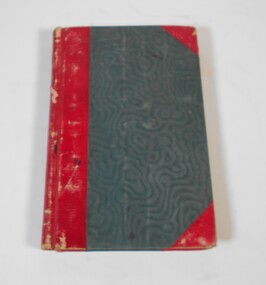 Bendigo Historical Society Inc.
Administrative record - Lands Office Bendigo - Residence area applications
Green and red hardbound book. It contains handwritten details of applications of residence area licenses under part II of the land's act 1869. It covers the period from 02-11-1881 to 25/11/1881.Application Register part 2, land act 1869 on the spine. On the first page in pencil: Soloman Paul, Hill Street Sandhurst.land office, residence area licenses -
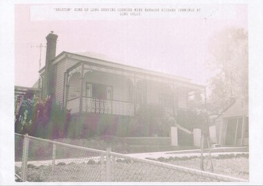 Bendigo Historical Society Inc.
Photograph - "Helston" home of Richard Jennings
Richard Jennings was a native of Cambourne, in Cornwall, born c. 1831. He arrived in Victoria in 1851, returned to Cornwall and then came back to Bendigo. He was the manager of several mines in the Bendigo goldfields and retired from these posts in 1891. His home "Helston" is in Backhaus St. Long Gully. Richard died in Feb. 1917 and was buried at the White Hills Cemetery.10563.5 Home of long serving Cornish Mine Manager Richard Jennings, who died at his residence "Helston" at Back Street, Long Gully. He was aged 86 years, and was one of the pioneers of the localityrichard jennings, long gully, "helston" -
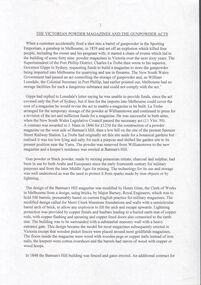 Bendigo Historical Society Inc.
Document - Victorian powder magazines
Gunpowder is very volatile and can be ignited by the smallest spark. Several horrific accidents resulted in NSW passing legislation to cover the safe storage of gunpowder but initially these laws did not apply to Victoria. this was rectified and the first Melbourne magazine was erected on Batman's Hill in 1845. The Victorian Gunpowder Act (1857) made local councils responsible for the safe storage of gunpowder. The Victorian government made L.909 available for a suitable building in Sandhurst. Built on Camp Hill it was finished in April 1857 and the first keeper, Mr J. F. Kerr was appointed in October 1857. Late in 1857, tenders were called for the building of a keeper's residence at the siteEleven pages typewritten document titled "the Victorian Powder Magazines and the Gunpowder Acts". Author unknown.melbourne, gunpowder acts, victorian legislation, powder magazines -
 Kew Historical Society Inc
Plan, Melbourne & Metropolitan Board of Works : Borough of Kew : Detail Plan No.1585, 1904
The Melbourne and Metropolitan Board of Works (MMBW) plans were produced from the 1890s to the 1950s. They were crucial to the design and development of Melbourne's sewerage and drainage system. The plans, at a scale of 40 feet to 1 inch (1:480), provide a detailed historical record of Melbourne streetscapes and environmental features. Each plan covers one or two street blocks (roughly six streets), showing details of buildings, including garden layouts and ownership boundaries, and features such as laneways, drains, bridges, parks, municipal boundaries and other prominent landmarks as they existed at the time each plan was produced. (Source: State Library of Victoria)This plan forms part of a large group of MMBW plans and maps that was donated to the Society by the Mr Poulter, City Engineer of the City of Kew in 1989. Within this collection, thirty-five hand-coloured plans, backed with linen, are of statewide significance as they include annotations that provide details of construction materials used in buildings in the first decade of the 20th century as well as additional information about land ownership and usage. The copies in the Public Record Office Victoria and the State Library of Victoria are monochrome versions which do not denote building materials so that the maps in this collection are invaluable and unique tools for researchers and heritage consultants. A number of the plans are not held in the collection of the State Library of Victoria so they have the additional attribute of rarity.Original survey plan, issued by the MMBW to a contractor with responsibility for constructing sewers in the area identified on the plan within the Borough of Kew. The plan was at some stage hand-coloured, possibly by the contractor, but more likely by officers working in the Engineering Department of the Borough and later Town, then City of Kew. The hand-coloured sections of buildings on the plan were used to denote masonry or brick constructions (pink), weatherboard constructions (yellow), and public buildings (grey). This plan, which covers parts of High Street, Pakington Street and Derby Street is dominated by two historic Kew mansions: ‘Konetta’ and ‘Ramornie’. Ramornie was constructed in 1890 for James Maitland Campbell, three times Mayor of Kew. Sold in 1940, it became a boarding house known as ‘The Towers’. Now a private residence again, it has only one of its three balconies remaining. The location of the missing two balconies can be seen on the plan. In 1903, the grounds of Ramornie included a large tennis court fronting Pakington Street. The rear of the property is shown as extending to Cobden Street. One of Kew’s oldest hotels, the Prospect Hill Hotel on the corner of High and Cobden Street was established in 1858. The outline of the hotel shown on the plan represents the second building on the site. During the 19th century it was often used for electoral meetings. The Prospect Hill Hotel was to be redeveloped again in 1928, by the local architect Robert McIntyre. Since the 1980s, the hotel has been a live music venue, the home of the Melbourne Jazz Club, a restaurant and a liquor outlet.melbourne and metropolitan board of works, detail plans, maps - borough of kew, mmbw 1585, cartography -
 Kew Historical Society Inc
Photograph, Marnie McLeod, Floods of the River Yarra at Kew, 1916
The donation was accompanied by the following letter from the donor: "Hi. I found these in with family photos. Taken by family as Mamie McLeod was living in Fellows Street, Kew, so would be near there. Retain (or discard) as you see fit." [Donor's name and address withheld from public view]. To gain an insight into the flood levels at Kew, it is worth reading newspaper accounts of the event. The Age published an article - Valuable Gardens Destroyed at Kew - on 25 September 1916: "VALUABLE GARDENS DESTROYED AT KEW. From the heights of Studley Park, Kew, a splendid view of the flood waters can be obtained, and yesterday afternoon, despite continuous rain, crowds of citizens assembled there to witness the spectacle. There is a vast stretch of water some 300 or 400 yards broad, above the foot bridge connecting Gipps-street, Collingwood, and Studley Park. The river is only about 3 feet from the top of the embankment connecting with the ramp of the bridge on the Studiey Park side. When the upper llood waters come down it is almost a certainty that tne embankment will be submerged and the bridge rendered impassible. Below the bridge the waters again stretch out, and have submerged all the low-lying land on the Collingwood side and invaded the back premises ot the Kodak Co., Phoenix Biscuit Factory, a tannery adjoining thereto, the Shamrock Brewery, and Chinese gardens in the vicinity. At Walmer-street-bridge, at the end of Studley Park, the low-lying land on the Kew side is covered with water to the depth of many feet. Tlie land in question is owned in a great part by Mr Frank Lavers who haa gone in for intense culture on a pretty liberal scale on both the slopes of the hill and on the river flat. On the latter he is cultivating many acres of asparagus, and has at a considerable cost spent three years in preparing the ground and installing an irrigation system, reticulated from the Yan Yean water supply. This year the asparagus was put down, and the plants were in a promising condition. Tlie flood waters are now flowing fast over the land. The crop is ruined, and three years' work and expenditure destroyed. Mr. Laver's private residence fortunately is high above flood level, but two houses he owns off Young-street have been flooded out. Having been warned in time, the tenants removed their furniture hefore the water came down to Mr. Laver's residence, where they themselves have been given accommodation in the meantime. All the river flats in East Kew are under water. One or two low-lying houses have been flooded. Chipperfield's boat shed at Willsmere is nearly covered, and some Chinese gardens in the vicinity are several feet under water."This, and the other three photographs donated of floods in Kew are believed to be the earliest in the collection. Together with our original MMBW River Yarra map showing flood levels, these items, when compared allow researchers to gain a visual perspective of the extent of the flood in 1916. Black and white photograph of flooded trees in Kew with rising dry ground in distance.Inscription on reverse in pencil: "Flood River Yarra Kew Vic"river yarra, kew, floods 1916 -
 Kew Historical Society Inc
Photograph, Marnie McLeod, Floods on the River Yarra at Kew, 1916
The donation was accompanied by the following letter from the donor: "Hi. I found these in with family photos. Taken by family as Mamie McLeod was living in Fellows Street, Kew, so would be near there. Retain (or discard) as you see fit." [Donor's name and address withheld from public view]. To gain an insight into the flood levels at Kew, it is worth reading newspaper accounts of the event. The Age published an article - Valuable Gardens Destroyed at Kew - on 25 September 1916: "VALUABLE GARDENS DESTROYED AT KEW. From the heights of Studley Park, Kew, a splendid view of the flood waters can be obtained, and yesterday afternoon, despite continuous rain, crowds of citizens assembled there to witness the spectacle. There is a vast stretch of water some 300 or 400 yards broad, above the foot bridge connecting Gipps-street, Collingwood, and Studley Park. The river is only about 3 feet from the top of the embankment connecting with the ramp of the bridge on the Studiey Park side. When the upper llood waters come down it is almost a certainty that tne embankment will be submerged and the bridge rendered impassible. Below the bridge the waters again stretch out, and have submerged all the low-lying land on the Collingwood side and invaded the back premises ot the Kodak Co., Phoenix Biscuit Factory, a tannery adjoining thereto, the Shamrock Brewery, and Chinese gardens in the vicinity. At Walmer-street-bridge, at the end of Studley Park, the low-lying land on the Kew side is covered with water to the depth of many feet. Tlie land in question is owned in a great part by Mr Frank Lavers who haa gone in for intense culture on a pretty liberal scale on both the slopes of the hill and on the river flat. On the latter he is cultivating many acres of asparagus, and has at a considerable cost spent three years in preparing the ground and installing an irrigation system, reticulated from the Yan Yean water supply. This year the asparagus was put down, and the plants were in a promising condition. Tlie flood waters are now flowing fast over the land. The crop is ruined, and three years' work and expenditure destroyed. Mr. Laver's private residence fortunately is high above flood level, but two houses he owns off Young-street have been flooded out. Having been warned in time, the tenants removed their furniture hefore the water came down to Mr. Laver's residence, where they themselves have been given accommodation in the meantime. All the river flats in East Kew are under water. One or two low-lying houses have been flooded. Chipperfield's boat shed at Willsmere is nearly covered, and some Chinese gardens in the vicinity are several feet under water."This, and the other three photographs donated of floods in Kew are believed to be the earliest in the collection. Together with our original MMBW River Yarra map showing flood levels, these items, when compared allow researchers to gain a visual perspective of the extent of the flood in 1916. Panoramic view, believed to be looking north towards Fairfield from the Zig-Zag Bridge on the River Yarra. The inscription on the reverese identifies it as taken before 1920.Inscription on reverse in ink "(pre 1920) Flood from Zig-zag bridge Yarra River, Kew Vic."river yarra, kew, floods 1916, zig-zag bridge -
 Kew Historical Society Inc
Photograph, Marnie McLeod, Flood, River Yarra, Kew, 1916
The donation was accompanied by the following letter from the donor: "Hi. I found these in with family photos. Taken by family as Mamie McLeod was living in Fellows Street, Kew, so would be near there. Retain (or discard) as you see fit." [Donor's name and address withheld from public view]. To gain an insight into the flood levels at Kew, it is worth reading newspaper accounts of the event. The Age published an article - Valuable Gardens Destroyed at Kew - on 25 September 1916: "VALUABLE GARDENS DESTROYED AT KEW. From the heights of Studley Park, Kew, a splendid view of the flood waters can be obtained, and yesterday afternoon, despite continuous rain, crowds of citizens assembled there to witness the spectacle. There is a vast stretch of water some 300 or 400 yards broad, above the foot bridge connecting Gipps-street, Collingwood, and Studley Park. The river is only about 3 feet from the top of the embankment connecting with the ramp of the bridge on the Studiey Park side. When the upper llood waters come down it is almost a certainty that tne embankment will be submerged and the bridge rendered impassible. Below the bridge the waters again stretch out, and have submerged all the low-lying land on the Collingwood side and invaded the back premises ot the Kodak Co., Phoenix Biscuit Factory, a tannery adjoining thereto, the Shamrock Brewery, and Chinese gardens in the vicinity. At Walmer-street-bridge, at the end of Studley Park, the low-lying land on the Kew side is covered with water to the depth of many feet. Tlie land in question is owned in a great part by Mr Frank Lavers who haa gone in for intense culture on a pretty liberal scale on both the slopes of the hill and on the river flat. On the latter he is cultivating many acres of asparagus, and has at a considerable cost spent three years in preparing the ground and installing an irrigation system, reticulated from the Yan Yean water supply. This year the asparagus was put down, and the plants were in a promising condition. Tlie flood waters are now flowing fast over the land. The crop is ruined, and three years' work and expenditure destroyed. Mr. Laver's private residence fortunately is high above flood level, but two houses he owns off Young-street have been flooded out. Having been warned in time, the tenants removed their furniture hefore the water came down to Mr. Laver's residence, where they themselves have been given accommodation in the meantime. All the river flats in East Kew are under water. One or two low-lying houses have been flooded. Chipperfield's boat shed at Willsmere is nearly covered, and some Chinese gardens in the vicinity are several feet under water."This, and the other three photographs donated of floods in Kew are believed to be the earliest in the collection. Together with our original MMBW River Yarra map showing flood levels, these items, when compared allow researchers to gain a visual perspective of the extent of the flood in 1916. Small black and white photograph of flooded trees in Kew.Inscription on reverse in ink "Flood R. Yarra Kew Vicriver yarra, kew, floods 1916 -
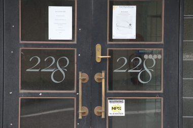 Kew Historical Society Inc
Photograph - Photographs (series), Richard Bowen, Sunninghill, 228 Cotham Road, 07/02/2020
'Sunninghill' at 228 Cotham Road (Kew) is an historically significant building due to its associations with Joseph Thomas (Bland) Holt (1851-1942), theatre entrepreneur and actor who lived at the house following his retirement in 1909. Sunninghill (aka Sunning Hill) was one of his residences in Victoria (also 'The Anchorage' at Sorrento). Following Holt's death at Sunninghill on 28 June 1942, the house was left to his wife. After her death the house was bequeathed to Lucy Coppin, daughter of George Coppin. The 'Shakespeare Window' in the State Library of Victoria was at one stage installed in the house. References 'Death of Mr Bland Holt: Great exponent of melodrama', The Argus, 30 June 1942, p. 3. Shoesmith D, 'Holt, Joseph Thomas (Bland) (1851-1942)', Australian Dictionary of Biography, Vol 4, 1972. 'The Shakespeare Window', State Library of Victoria website.Exterior photographs (digital) of Sunninghill, 228 Cotham Road, Kew VIC 3101. sunninghill - 228 cotham road - kew (vic), joseph thomas (bland) holt, lucy coppin -
![Dandenong State Forest, at Fern Tree Gully / [by] Nicholas Caire, circa 1876](/media/collectors/550653872162f11fb04854aa/items/577750a4d0cdd10a5c15e22b/item-media/57775147d0cdd10a5c165a58/item-fit-380x285.jpg) Kew Historical Society Inc
Kew Historical Society IncPhotograph, Anglo-Australasian Photographic Company, Dandenong State Forest, at Fern Tree Gully, c. 1876
Nicholas Caire was born on Guernsey in the Channel Islands in 1837. He arrived in Adelaide with his parents in about 1860. In 1867, following photographic journeys in Gippsland, he opened a studio in Adelaide. From 1870 to 1876 he lived and worked in Talbot in Central Victoria. In 1876 he purchased T. F. Chuck's studios in the Royal Arcade Melbourne. In 1885, following the introduction of dry plate photography, he began a series of landscape series, which were commercially successful. As a photographer, he travelled extensively through Victoria, photographing places few of his contemporaries had previously seen. He died in 1918. Reference: Jack Cato, 'Caire, Nicholas John (1837–1918)', Australian Dictionary of Biography, National Centre of Biography, Australian National UniversityAn original, rare photograph from the series 'Views of Victoria: General Series' by the photographer, Nicholas Caire (1837-1918). The series of 60 photographs that comprise the series was issued c. 1876 and reinforced a neo-Romantic view of the Australian landscape to which a growing nationalist movement would respond. Nicholas Caire was active as a photographer in Australia from 1858 until his death in 1918. His vision of the Australian bush and pioneer life had a counterpart in the works of Henry Lawson and other nationalist poets, authors and painters.Albumen silver photograph on boardprinted in ink on support l.c.: DANDENONG STATE FOREST, AT FERN TREE GULLY. / COPYRIGHT REGISTERED. printed in ink on support reverse c.: VIEWS OF VICTORIA. / (GENERAL SERIES.) / No. 12. / DANDENONG STATE FOREST, AT FERN TREE GULLY. / Fern Tree Gully is one of the favourite resorts for pleasure-seekers on holiday occasions. This scene is taken / from the camping ground at the entrance to the Gully. The residence in the centre of the picture is that of the / Forest-keeper, Mr. Kennedy, who has charge of the Dandenong State Forest. The trees on the hill at the back of / the residence, through apparently diminutive, are in reality gigantic ones, measuring in many instances from 15 to / 20 feet in circumference at the base. printed in ink on support reverse l.c.l.: J.W. FORBES, Agent, printed in ink on support reverse l.c.: ANGLO-AUSTRALASIAN PHOTOGRAPHIC COMPANY, MELBOURNE. printed in ink on support reverse l.c.r.: 10 Temple Court, Collins Street West.nicholas caire (1837-1918), landscape photography, ferntree gully -
 Kew Historical Society Inc
Plan - Subdivision Plan, 10 Fine Villa Sites: Ermington Estate, Kew Heights, ca. 1917
Pru Sanderson, in her groundbreaking ‘City of Kew Urban Conservation Study : Volume 2 - Development History’ (1988), summarised the periods of urban development and subdivisions of land in Kew. The periods that she identified included 1845-1880, 1880-1893, 1893-1921, 1921-1933, 1933-1943, and Post-War Development. These periods were selected as they represented periods of rapid growth or decline in urban development. An obvious starting point for Sanderson’s groupings involved population growth and the associated economic cycles. These cycles also highlighted urban expansion onto land that was predominantly rural, although in other cases it represented the decline and breakup of large estates. A number of the plans in the Kew Historical Society’s collection can also be found in other collections, such as those of the State Library of Victoria and the Boroondara Library Service. A number are however unique to the collection.The Kew Historical Society collection includes almost 100 subdivision plans pertaining to suburbs of the City of Melbourne. Most of these are of Kew, Kew East or Studley Park, although a smaller number are plans of Camberwell, Deepdene, Balwyn and Hawthorn. It is believed that the majority of the plans were gifted to the Society by persons connected with the real estate firm - J. R. Mathers and McMillan, 136 Cotham Road, Kew. The Plans in the collection are rarely in pristine form, being working plans on which the agent would write notes and record lots sold and the prices of these. The subdivision plans are historically significant examples of the growth of urban Melbourne from the beginning of the 20th Century up until the 1980s. A number of the plans are double-sided and often include a photograph on the reverse. A number of the latter are by noted photographers such as J.E. Barnes.In November 1917, the Ermington Estate was advertised as an ‘Executor’s Sale’. It included the 10-roomed villa residence, ‘Ermington’, home of the late Mrs. Lorimer, and 10 ‘magnificent allotments’. The plan in the Kew Historical Society Collection is a little more specific. Ermington is described as having 9 Rooms &c. and there are 11 lots shown on the west side of Hillcrest Avenue. In the plan, the latter is named as ‘Hill Crest Avenue’. The plan indicates that the subdivision was based on the surveying work of Johnson & Tait. Opposite Ermington, the existing house ‘Parkhill’ is identified. A faded stamp on two parts of the plan indicates that it was in the possession of Jas. [R.] Mathers, Financial Agent, [136] Cotham Road, Kew.subdivision plans - kew, ermington heights estate - kew heights -
 Surrey Hills Historical Society Collection
Photograph, Surrey Hills Mounted Police Station (Dem.)
Surrey Hills Mounted Police Station was located at 5 Suffolk Road (dem.) from 1889-1914. It was a police residence with two rooms as the police office and workshop. There were stables on the back fence. The property adjoined Wyclif Church in Norfolk Road. Gilbert McCallum rented from c.1914-1923 when he built a home in Westminster Street. It is his son Archie who can just be seen on the front steps. Archie remembers the 2 storied stables with a gantry for hauling feed sacks up with a block and tackle, then a polished wood slide to send the feed down. The McCallum children and local friends found this to be a marvellous slide. David McPhie, ex-police force, lived here with his family from 1923-c.1950. A black and white photograph showing a mid to late Victorian style weatherboard house with decorative brackets under the eaves. The verandah is of timber with decorative timber fretwork.surrey hills mounted police, suffolk road, surrey hills, wyclif church, (mr) gilbert mccallum, (mr) david mcphie, police, (master) archie mccallum -
 Surrey Hills Historical Society Collection
Photograph, Centenary Movie Snap, Frederick John (Fred) Ambler
Frederick John Ambler was an upholsterer. Married Beatrice Annie Martin in 1897. Fred was born in Essex, UK in 1873. The Amblers has a large family: Gordon Frederick William (1898-1910); Malcolm George (1900-1965); Daisy May (1904-1904); Leon Verde (1904-1904); Garnet Leslie (1904-1904); Ruby Isobel (1906-2004); Hector Leon (1909-1994); Sylvia Beatrice (1912 - ); Daisy May (1914-2009); Ronald Edward (1915-1990); Jean Mavis (1918-2001) plus Dorothy (dates not known). Residence: 1900-1914: 59 Sunbury Crescent; 1914-1950): 362 Canterbury Road (residence and workshop) in the Hansen's Terrace. Fred died at home (362 Canterbury Road) on 27 December 1947. He is buried in Box Hill Cemetery - M-201-0035 along with his wife. Beatrice's parents lived at 18 Lorne Parade, Surrey Hills. Black and white formal portrait of Fred Ambler in a dark suit."MRS. D. CARLSON / 1/80 WATTS ST/ BOX HILL NTH / 898 3621" Separately "FRED AMBLER" Also stamped with the photographer's details.frederick john ambler, 362 canterbury road, 59 sunbury crescent, mrs beatrice annie ambler, miss beatrice annie martin, fred ambler, box hill cemetery -
 Surrey Hills Historical Society Collection
Photograph, Alpha Photo Services, Frederick John (Fred) Ambler and his wife Beatrice Annie (nee Martin)
Frederick John Ambler was an upholsterer. Married Beatrice Annie Martin in 1897. Fred was born in Essex, UK in 1873. The Amblers has a large family: Gordon Frederick William (1898-1910); Malcolm George (1900-1965); Daisy May (1904-1904); Leon Verde (1904-1904); Garnet Leslie (1904-1904); Ruby Isobel (1906-2004); Hector Leon (1909-1994); Sylvia Beatrice (1912 - ); Daisy May (1914-2009); Ronald Edward (1915-1990); Jean Mavis (1918-2001) plus Dorothy (dates not known). Residence: 1900-1914: 59 Sunbury Crescent; 1914-1950): 362 Canterbury Road (residence and workshop) in the Hansen's Terrace. Fred died at home (362 Canterbury Road) on 27 December 1947. He is buried in Box Hill Cemetery - M-201-0035 along with his wife. Beatrice's parents lived at 18 Lorne Parade, Surrey Hills. Small black and white square portrait of Fred and Annie Ambler against a paling fence."ANNIE & FRED/ AMBLER/ D. CARLSON / 1/80 WATTS ST/ BOX HILL NTH / 898 3621" Also stamped with "2241" plus "ALPHA / PHOTO SERVICES/ BOX HILL"frederick john ambler, 362 canterbury road, 59 sunbury crescent, mrs beatrice annie ambler, miss beatrice annie martin, fred ambler, box hill cemetery -
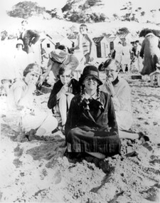 Surrey Hills Historical Society Collection
Photograph, Stalker family beach picnic, 1930s
Associated with the Stalker family of Surrey Hills. Betty Neil Smith (Stalker) was born in 1919 in Balwyn (Surrey Hills). She was one of 4 daughters of Alexander MacLaren Stalker (1885-1970/1973) and Charlotte Eleanor Hayward (1884-1953) who were married in 1911. Her sisters were Ruth McLaren Stalker (1913, Surrey Hills), Joan Winnock Stalker (1917, Surrey Hills) and Beatrice Mary Stalker(1919). Their mother Charlotte Hayward was a teacher prior to her marriage. Their father Alexander, an accountant, lived in Wattle Valley Road, Canterbury in 1910. From 1912-1931 they are listed at ‘Benwerrin’, (44) Wandsworth Road, Surrey Hills. This was later the home of Beatrice Mary and Howard Everard. Betty, Ruth and Joan later lived at 9/48 Wandsworth Road. it is assumed that the photo is of the Stalker girls and given their parents' later residence at Brighton, this may have been taken at Brighton beach. This photo documents part of the social history of a family with a long and strong association with Surrey Hills. The backdrop of the typical bathing boxes used for changing into swimsuits, for lunch and for storing sports and beach gear, documents beach recreation and culture of the 1930s. For many years in the late nineteenth century, Brighton was Melbourne's favourite seaside destination. The now iconic bathing boxes were a response to Victorian ideas of morality and sea bathing. There are 82 Brighton bathing boxes, which protected by a heritage overlay because of their uniform scale and proportion, building materials, sentry order alignment. All retain their classic Victorian architectural features with timber framing, weatherboards and corrugated iron roofs. They remain as they did over one hundred years ago, as licensed bathing boxes. Service amenities such as electricity or water were never connected.A black and white photograph of many people enjoying the beach. There are bathing boxes in the background and some ti-tree beyond that.uniforms, clothing and dress, bathing boxes, stalker family -
 Surrey Hills Historical Society Collection
Photograph, 1 Russell Street, Surrey Hills in 1988
1 Russell Street was built in 1888 and from 1888–1905 (maybe 1911, as his death notice says he died at Russell Street) it was the home of James Burrell, a blacksmith. His smithy was on the corner of Canterbury Road. In 1893 a block of land (No.3 ) was bought to establish the fire station and James Burrell acted as fire officer and stored the reel and hose until the station was built. From 1911–1928 it was the fire station residence, as the brigade gained status. James Burrell (1860-1911) married Elizabeth Wilson (1862-1925). She was daughter of Edward Wilson. They had 4 children: James Herbert, known as Bert (1888-1953); Aleck (1890-1951); William Spencer, known as Bill, (1893-1976) and Elsie May (1898-1990). Both James and Elizabeth Burrell are buried in Burwood Cemetery. From 1930–1943 Michael Ginnane, retired station master, and members of his family lived in the house. Michael Ginnane (1864-1935) married Annie Mary Brock (1868-1945). Both were born in the Ballarat area. They had 10 children. From 1913-1917 he was station master at Woodend. In the 1925 electoral rolls the family is listed as living at Surrey Hills station. There was a station master's house adjacent to the station (demolished and the site now part of the car park accessed off Blackburn Street). They are again listed here in the 1925 electoral roll. By 1931 they are at 1 Russell Street and he is listed as a retired station master. The following children lived in Surrey Hills: John James (Clerk) - 1922 Mary Ellen (HD) - 1922, 1925, 1931 Michael Thomas (labourer) - 1922 Annie Florence (dressmaker) - 1925, 1931 William Patrick (railwayman) - 1925 Elizabeth Catherine (sales) - 1931 Patrick Leo (postman) - 1931. A black and white photograph taken on an angle from across the street of a mid-late Victorian style cottage with multi-coloured brickwork. There is a large tree in the front garden, no fence and a letterbox on a lean.(mr) james burrell, blacksmiths, canterbury road, surrey hills, fire officers, (mr) michael ginnane, station masters, fire stations, mid-victorian style, (miss) elizabeth wilson, (mrs) elizabeth burrell, james herbert burrell, aleck burrell, william (bill) spencer burrell, elsie may burrell, (miss) annie mary brock, (mrs) annie mary ginnane, john james ginnane, (miss) mary ellen ginnane, michael thomas ginnane; (miss) annie florence ginnane; william patrick ginnane; elizabeth catherine ginnane; patrick leo ginnanean), late-victorian style, russell street -
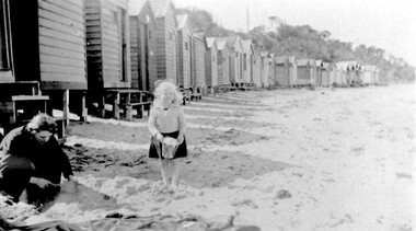 Surrey Hills Historical Society Collection
Photograph, Beatrice Mary Stalker, later Mrs Howard Breedon Everard, at the beach, 1930s
Mary Stalker’s engagement notice in The Argus in July 1947 indicates that she was the youngest daughter of Mr & Mrs A M Stalker of Montlare [Monclair] Avenue, North Brighton. It announces her engagement to ”Cr Howard Breedon Everard JP Ev-Ron, Woori Yallock, Youngest son of Hon WH Everard Wellington St Kew and the late Mrs Everard.” Beatrice Mary Stalker was born in 1919. Her parents were Alexander MacLaren Stalker (1885-1970/1973) and Charlotte Eleanor Hayward (1884-1953) who were married in 1911. Her sisters were Joan Winnock Stalker, Betty Neil Stalker and Ruth McLaren Stalker. Charlotte was a teacher prior to her marriage. Alexander, an accountant, lived in Wattle Valley Road, Canterbury in 1910. From 1912-1931 they are listed at ‘Benwerrin’, Wandsworth Road, Surrey Hills. Mary Stalker married in 1949 and by 1954 she and Howard were living at 44 Wandsworth Road, Surrey Hills, which was their home for decades. Howard was born in 1914 and died in October 2010: "EVERARD. - Howard Breedon. In loving memory of Howard, who lived life to the full to the very end of his 96 years. Greatly loved and honoured by Mary, Rosemary, David, Elizabeth, John and extended families." Beatrice Mary Everard died on 25 September 2019, aged 93. it is assumed that the woman in the photo is Mary's mother, Charlotte Eleanor Stalker (nee Hayward). The photo taken at the beach in 1930's may have been at Brighton, given the family’s later association with the suburb. This photo documents part of the social history of a family with a long and strong association with Surrey Hills. The backdrop of the typical bathing boxes used for changing into swimsuits, for lunch and for storing sports and beach gear, documents beach recreation and culture of the 1930s. Given the family's later residence in Brighton, this may well have been taken at Brighton Beach. For many years in the late nineteenth century, Brighton was Melbourne's favourite seaside destination. The now iconic bathing boxes were a response to Victorian ideas of morality and sea bathing. There are 82 Brighton bathing boxes, which protected by a heritage overlay because of their uniform scale and proportion, building materials, sentry order alignment. All retain their classic Victorian architectural features with timber framing, weatherboards and corrugated iron roofs. They remain as they did over one hundred years ago, as licensed bathing boxes. Service amenities such as electricity or water were never connected.A black and white photograph of a lady and little girl on the beach. There is a row of bathing boxes behind them.(miss) mary stalker, bathing boxes, (mrs) mary everard, (miss beatrice mary stalker, (mrs) beatrice mary everard, (mrs) charlotte eleanor stalker, (miss) charlotte eleanor hayward -
 Surrey Hills Historical Society Collection
Photograph, Nethercourt Private Hospital in Union Road Surrey Hills, 1976
The 3 front blocks facing Union Road were subdivided off in circa 1967, so this building now faces Barton Street. Since 1984 it has been a private residence. It was originally built in c1890 and from 1896 it was used as facilities for Surrey College, a private boys' boarding school. Dr F Darling was Principal. From 1935-1960s it became Nethercourt Private Hospital. This had previously operated from 1921 in Wilson Street. Later it was known as St Jude's Hospital; this closed in 1983.Black and white photo of Nethercourt Private Hospital taken from Union Road. It shows a 3 storey brick rendered building painted in a light colour. It is fronted by a paling fence and with a vacant area in the foreground, on which there is a bare-leafed mature tree to the right and an evergreen tree to the left. The fence appears to be new suggesting that the photo was taken at the time of subdivision of the land.The original has the following inscriptions: Top: In black biro "D Hall our collection / hall / family" in Jocelyn Hall's writing. Below in lead pencil "Old entrance of / St Judes" - unknown hand; presumed to be Duncan Hall's. In black biro in Jocelyn Hall's hand: "Taken c. 1976." nethercourt private hospital, the surrey college, norwich hall, st judes hospital, barton street, medical services, education, dr f darling -
 Surrey Hills Historical Society Collection
Work on paper - Photograph, Nethercourt Private Hospital, Surrey Hills, c 1924, 1924
Notes from a previous collection coordinator indicate that Miss Lucy Musselwhite (Lillywhite) opened the hospital in 1914 and Matron Eliza Tank took it over in 1921 and named it Nethercourt Private Hospital. However recent research suggests that Miss Musselwhite (name confirmed) moved from Tooronga to Wilson Street some time between 1903 and 1909. She and her mother Elizabeth are listed in the 1909 electoral rolls in Wilson Street and Lucy's occupation is given as nurse. (It is of course possible that the property was a residence only at this time and later opened as a private hospital.) The name Nethercourt was used prior to Matron Eliza Tank taking over. Her daughter Irene was also a nurse at Nethercourt. Lucy Musselwhite was born in 1873 in Hampshire. She married Henry James Dore in later life and lived in Brenbeal Street, Balwyn. She died in 1955. In 1930 / 1935 Matron Tank transferred the hospital to 219-223 Union Road. Later it was known as Norwich Hall / St Jude's. Mosgiel Hospital in Mont Albert Road also opened in 1924. After this time home births became less common. Nethercourt Hospital closed in the 1960s.Small hospitals such as this one were primarily used for midwifery, preceding the development of larger centralised general hospitals. Black and white photo of Nethercourt Private Hospital at 11 Wilson Street in c 1924 taken from the street in winter. The building is Victorian in style; block-fronted with lacework detail to the verandah and has 2 chimneys. It is set behind a wooden picket fence behind which is a well-manicured hedge which appears to have been grown across the front entrance gate.nethercourt private hospital, midwifery, hospitals, matron eliza tank, miss lucy musselwhite, miss irene tank, mrs irene anderson -
 Surrey Hills Historical Society Collection
Photograph, McPhie family at back of Mounted Police Station, 5 Suffolk Road, Surrey Hills
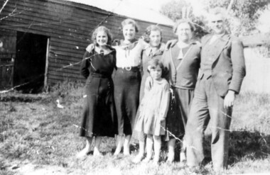
"Sgt. David McPhie and some of his family/at Suffolk Road Mounted Police Station./Stables are shown in background./Courtesy - Mrs. P. Scales (nee McPhie)." The police established a station at 5 Suffolk Road in 1889. The first policeman was Constable Patrick Healey soon after assisted by Sgt Wilson. Constable David McPhie (1887-1963) was married to Jessica Beatrice McErvale (1891-1962) in 1914. They had a son - Angus (1916-1971) and a daughter Jean Cameron (1918-1985); she was born in Surrey Hills. In 1919 electoral rolls David McPhie is listed as a policeman at 5 Suffolk Road. Police gazettes list him as discharged on 2/11/1923. The family continue to live at 5 Suffolk Road and thereafter he is listed as a labourer. Entry in 'Surrey Hills In Celebration of the Centennial 1883-1983' states there was a mounted troopers' station at 5 Suffolk Road from 1889-1914. It was later at 5 Essex Road and then in 1923 moved to 171 Union Road (later the doctor's surgery and residence) and then to 93 Union Road where it stayed until 1947. It is not known how the donor was related to David McPhie.Image of a man, identified as Sgt. David McPhie, with five female members of his family, standing in front of the stables of the Mounted Police Station at 5 Suffolk Road, Surrey Hills.people, families, family groups, police, policemen, surrey hills mounted police station, horses, stables, suffolk road, david mcphie, miss jessie beatrice mcervale, mrs jessie beatrice mcphie -
 Surrey Hills Historical Society Collection
Photograph, 152 Union Road Surrey Hills
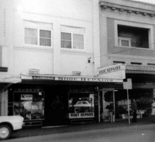
Eric Pringle's boot and shoe repair shop, with Ives fruit shop adjoining were both were both important local businesses. Those who remember Eric said nothing was too difficult or unimportant. He was so dexterous that he could carry on a conversation with tacks in his mouth. Eric James Pringle (c1904-1980) married Lillian May Gertrude Collins in 1928. He had boot making businesses in Glenferrie and Kew before coming to Surrey Hills. He enlisted in WW2 (No V363574). He is first listed at 152 Union Road in 1943. The business continued at this address but the family are listed at 283 Mont Albert Road in later electoral rolls.A black and white photograph of a shoe repair shop. A sign identifies it as E.J. Pringle's shop. There appears to be a residence above the shop.union road, surrey hills, boot makers, eric james pringle