Showing 186 items matching "lime"
-
 Warrnambool and District Historical Society Inc.
Documents (Bruce Morris), OfficeWorks Ltd Australia, distributors, 2018 (folders)
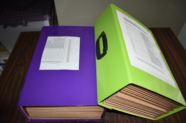
These folders contain the historical notes written by Bruce Morris in regard to the life story and achievements of George Lance. These notes were used by Bruce Morris to write a great number of historical articles on George Lance and these were mostly published in the Warrnambool Standard. Bruce Morris (1903-1986) was the editor of the Warrnambool Standard from 1946 to 1968. During that time he was prominent in community activities in Warrnambool and was well-known for the great number of historical articles he published in his paper, making him one of Warrnambool’s most important historians. George Lance, the subject of the notes in these folders, was Bruce Morris’ grandfather. George Lance (1933-1901) was a plumber particularly associated with the development and use of gas power in Warrnambool and the inventor of the Eureka Pump and the Lance Patent Cess Pan. He was also a writer of historical articles, a musician with the Warrnambool Artillery Band and an important artist in the town, with some of his works of art in the Warrnambool Art Gallery today. He is regarded as the person most responsible for the establishment of the Warrnambool Art Gallery in the 1880s. Bruce Morris’ notes include material on George Lance’s involvement with the Warrnambool Bowls Club, the School of Arts, the Mechanics’ Institute, the Baptist Church and the Manchester Unity Independent Order of Oddfellows.These folders are of considerable importance as they contain the historical notes of Bruce Morris regarding his grandfather, George Lance. Both Bruce Morris and George Lance are significant in Warrnambool’s history, the former as an important historian and newspaper editor and the latter as an inventor, writer, artist, musician and a person regarded as the 19th century founder of the Warrnambool Art Gallery .1 This is a lime-green rectangular-shaped folder made of stiffened cardboard with a black plastic handle on the top with a black plastic catch on the side. Inside the folder are paper inserts that fold up in concertina fashion. In the inserts are twelve blue plastic folders that contain handwritten and typed material. .2 This is a purple rectangular-shaped folder made of stiffened cardboard similar to .1 above. It has a black plastic handle on the top and a black plastic catch on the side. Inside the folder are paper inserts that fold up in concertina fashion. In the inserts are twelve blue plastic folders that contain handwritten and typed material. George Lance Folders. Bruce Morrisbruce morris, warrnambool, george lance, warrnambool, history of warrnambool -
 Bendigo Historical Society Inc.
Ephemera - SHOWBAGS COLLECTION: HEINZ BABY FOODS SHOWBAG
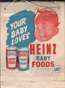
A paper showbag. The design is in red and blue colours over a white background. On one side the words: Your Baby Loves Heinz Baby Foods, there is a drawing of a baby face and two cans o food, one Heinz junior foods the other Heinz strained foods. The number 57 in blue at bottom right. On the other side the faces of two youths a boy and a girl and the words: Easy as winking! mix yourself a beaut drink of Heinz-Ade, 1 small packet makes 4 big pints of refreshing drink! Orange, Lemon, Raspberry, Lime, Fruit Cup, Ginger Beer.business, retail, advertising, business advertising usually found at agricultural shows and other promotional activities. -
 Bendigo Historical Society Inc.
Photograph - HARRY BIGGS COLLECTION: R JEFFERY TIMBER MERCHANT & IRONMONGER
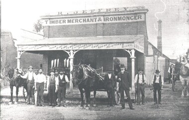
Photograph. Harry Biggs Collection. 2 black & white photos (1 smaller) of 8 men with horses & drays standing in front of the R Jeffery Store. At the back of this group can be seen 3 people under the verandah. At the side is another man & also a horse & dray. On the verandah structure are the words - Bar, Hoop, sheets galvanised iron, zinc, lime cement, laths, doors, sashes, cast shear Blistered Steel. At the side of the verandah are the words Timber & Iron Yard. Plate 126 Premises of Jeffery Bros, Victoria Street, Eaglehawk. (Robinson Photo). 1 photocopy of these photos.Robinson Photoplace, building, commercial, harry biggs collection, r jeffery timber merchant & ironmonger, eaglehawk -
 Tatura Irrigation & Wartime Camps Museum
Uniform - Afrika Korps Replica Shirt
Replica shirt. Khaki green drill fabric, Epaulettes edged with lime green binding, Yellow/tan insignia on lapels, German Eagle & Swastika patch on right chest, Korps insignia patch on left arm. Pleat on back hemline, sleeves have button cuff closure. 4 front pockets with button down flaps, 5 blueish buttons on front, same buttons on pockets and epaulettes. 2 metal hooks at side waistline for belt. Inside pocket linings are yellow cotton fabric. Right sleeve has a tan band with silver stripes and AFRIKAKORPS in silveruniforms, german, afrika korps -
 Otway Districts Historical Society
Photograph, R. Preston, Kawarren: an UP goods train, 1958, 14 December 1958
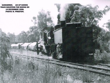
Kawarren was an early timber and limestone loading point. Timber was shipped in by Watson and Facey, Condon Brothers, and Coppock, amongst others, some of which had tramways up to 6.5 km long to the station. Bushfires roared through the area in 1939 and made the area unworkable. An outcrop of limestone existed near Kawarren but it was not until the railway was built that it became workable. 360 metres north of Kawarren station two then three kilns were erected, and later a shed and covered area over a short length of the rail siding in order to prevent rain damage to the lime while it was being loaded. Sluicing was introduced, and the tramway was extended further when the quarry ate deeper into the hillside. Limestone traffic of around 2,000 tonnes each year kept the station busy until the trade ceased in 1957.B/W. On the 14 December 1958 at Kawarren an UP goods train shunts on the siding. A man is talking to the engine driver while another man approaches the engine.kawarren; railways; timber; lime; -
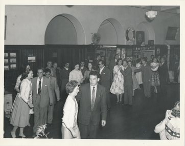 Mission to Seafarers Victoria
Photograph, Melbourne Harbour Trust, Dance in the Flying Angel Club, 1959
The life buoy from the Largs Bay located above the bar helps dating the photograph to post 1957: Largs Bay was launched in 1921, as a mixed passenger/cargo ship. During WW2 she took part in a large number of convoys.nIt was scrapped in 1957 so had a service life of 36 years. Her sister ships were Jervis Bay, Moreton Bay, Esperance Bay and Hobsons Bay. She carried many passengers to Australia to start new lives after WW2. In the bar we can notice advertising helping dating: Peters ice cream Choc Wedge (launched in 1949) at 6d, Cottee's flavoured drinks (Passiona, Lime Coola, Orange, Lemon) In the 1950s, the ladies from the LHLG were still active and dancing with seamen was part of their activities.BW photograph depicting couples dancing in the Flying Angel Club of the Flinders Street Mission.lhlg, dance, seamen, flinders street, cottees, lime coola, passiona, orange, lemon, choc wedge, life buoy, largs bay, ice cream, peters -
 Warrnambool and District Historical Society Inc.
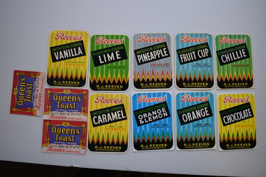
Label, Gaspars Modern Print, Reeves, 1930s
These labels come from the Warrnambool Reeves Cordial Factory. John Reeves came to Warrnambool about 1900 and managed the cordial bottling plant in Banyan Street for Jim Kelly who traded under the name of the previous cordial manufacturer, J. S. Rowley. In 1931 John Reeves purchased the cordial factory in Koroit Street from the estate of John Fletcher. John Reeves’ son, Reg managed the cordial business in Koroit Street until 1946 when he took over from his father and carried on the business until his death in 1972. In 1977 Reeves’ son-in-law carried on the business under the trading name of Reeves. The building in Koroit Street that stands today was erected in 1957 when the original building was demolished. These labels are of interest because they are colourful and pleasing to the eye and because the Reeves Cordial Factory was a major business in Warrnambool for several decades in the 20th century..1 to .9 Piece of paper with curved edges with multi-coloured printing and coloured geometric decoration. .10 A piece of paper with yellow, red and white printing and images of a crown and a stage curtain. .1 Reeves’ Imitation Cordial Vanilla .2 Reeves’ Imitation Cordial Caramel .3 Reeves’ Flavoured Cordial Lime .4 Reeves’ Flavoured Cordial Chocolate .5 Reeves’ Flavoured Cordial Chillie .6 Reeves’ Flavoured Cordial Orange .7 Reeves’ Flavoured Cordial Orange & Lemon .8 Reeves’ Flavoured Cordial Fruit Cup .9 Reeves’ Flavoured Cordial Pineapple .10 Queen’s Toast Artificially Coloured Reeves Warrnambool reeves cordial factory, history of warrnambool -
 Melbourne Royal
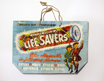
Memorabilia - Showbag, Wilmers & Gladwin Pty Ltd, Life Savers Showbag, c. 1959
Life Savers were invented in America in 1912 and produced under an agreement in Australia from 1921. The name refers to the fact that the hole in the middle will prevent choking if the sweet is swallowed whole.Life Savers showbag, no content: paper bag with string cord handle, printed in colour; one side showing a roll of Butter Scotch Life Savers and two Scottish children dancing under it; the other, a roll of Pep-O-Mint Life Savers, set against an Arctic background[obverse] 3 PACKETS FOR 1-' EVERYWHERE / BUTTER SCOTCH / LIFE SAVERS / THE CANDY WITH THE HOLE / Also obtainable / in following flavours: / Crystomint - Stick-O-Pep - Orange - Lemon - Lime" [reverse] Cooling Pep-O-Mint Life Savers, the candy mint with the hole / Also obtainable in following flavours: Spear-O-Mint - Assorted floral - Vi-O-Let - Musk - Clove - Thirst - An-O-Sed / 3 packets for 1'- everywhere / [bottom] Wilmers & Gladwin Pty Ltdconfectionery, lifesavers, showbag, commercial -
 Flagstaff Hill Maritime Museum and Village
Domestic object - Fruit Press, 1890-1900
The fruit juice or lemon squeezer is a small kitchen utensil designed to extract juice from lemons or other citrus fruit such as oranges, grapefruit, or lime. It is designed to separate and crush the pulp of the fruit in a way that is easy to operate. Lemon squeezers can be made from any solid, acid-resistant material, such as plastic, glass, metal (usually aluminum) or ceramic. The oldest known lemon squeezers were found in Kütahya, Turkey and date to the first quarter of the 18th century. These ceramic presses are in the traditional style of Turkish pottery of the 18th century and have a superficial resemblance to today's press equipment with cones, though they are designed differently. These examples were individually made, and specially designed for making the then popular citrus drink sorbet. Lemons are not native to northern Turkey, though during the 17th and 18th centuries they were imported in bulk to Constantinople.The fruit juice press is an example of early 20th century kitchen utensils and is not associated with an historical event, person or place, provenance is unable to be determined at this time and the item is believed to have been made around 1900. This item is currently being used in Flagstaffs Hill village display and regarded as significant as it demonstrates domestic kitchen utensils used around the turn of the 19th century and today is a collectable item. Vintage lemon/citrus fruits squeezer cast iron juicer with two sections hinged together strainer on one section has holes for letting liquid escape.Noneflagstaff hill, warrnambool, shipwrecked coast, flagstaff hill maritime museum, flagstaff hill maritime village, great ocean road, food press, food preparation, fruit juice press, kitchen utensil -
Federation University Historical Collection
Pamphlet - Visitor Guides, Ballarat College of Advanced Education Visitor Guides for Mt Helen Campus, 1978 - 1987
Ballarat College of Advanced Education is a predecessor of Federation University .1 Pale green trifold pamphlet with black writing 1978 .2 Lime Green trifold pamphlet with black writing 1979 .3 Yellow trifold pamphlet with black writing and a white insert 1980 .4 Pale blue trifold pamphlet with blue writing 1981 .5 Mustard coloured A5 booklet with black printing 1982 .6 Pale Yellow A5 booklet with black printing 1983 .7 Dusty yellow A5 booklet with black printing 1985 .8 White four fold pamphlet with Florescent Pink background with black and white images and black writing 1986 .9 Royal Blue four fold pamphlet with black and white writing and images 1987ballarat college of advanced education, open day, visitors guide, education, applied science, art, business studies, general and community studies, engineering, librarianship, humanities, e.j. barker -
 RMIT Design Archives
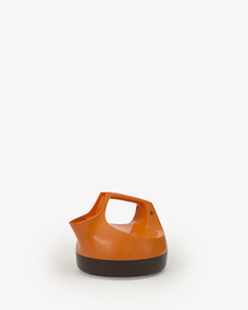
Domestic object - Object, General Electric KE12 Kettle, designed by Barry Hudson
The GE12 Electric Kettle was designed by Barry Hudson for General Electric and in 1978 won the Australian Design and the Prince Philip Prize awards for Australian Design. The kettle was innovative in many ways; it was an early example of an all plastic electric kettle with a single-handed opening-spout. According to design historian Ian Wong ‘The use of an integral hinge for the spout opening mechanism utilised the unique live hinge property of polypropylene, now common but at the time a novel use and very efficient to manufacture.’ The kettle was available in Carpentaria Orange, Blaze Yellow and Lime Green with a contrasting base. Barry Hudson (1935-2008) studied Mechanical Engineering at the Melbourne Technical College (MTC). In the 1970s he was Research and Development Manager at General Electric, and he also worked with the industrial design practice Rosenfeldt, Gherardin and Associates. He established Barry Hudson Industrial Design in the 1980s and began a teaching career at the former MTC, now known as RMIT University. Ann Carew, 2020 1978 the Kettle won an Australian Design Award and the Prince Philip Prize for Australian Design.Orange and brown electric kettlekettle, industrial design, rmit university, domestic appliances -
 Vision Australia
Photograph - Image, Illawarra images
Illawarra was the name given to the Geelong office of the Association for the Blind. These physical photographs were unfortunately too damaged to be retained in the collection, so a digital image was taken. 1. 1977 - Unnamed people undertaking carpentry at Illawarra. 2. 1970 to1980's - The Illawarra building in Pakington Street, Newtown. 3. 1970 to 1980's - A seascape mural with raised sea animals and corals was presented by the Embroiders Guild for the benefit of AFB members. An unknown female is feeling the mural. 4. 1970 to 1980's - A fragrance garden at Illawarra completely maintained by the Geelong Pelargonium Society, enables AFB members to enjoy the plants by their distinctive perfumes of lemon, lime, nutmeg and peppermint. A female stands in front of a garden bed and smells a pelargonium leaf. 5. 1982 - To encourage independence from costly and impersonal health services, diabetics attend Illawarra to learn self-management of their condition at home. A dietitian speaks with diabetics on treatment. 6. 1976 - The Geelong office of the AFB at Illawarra.6 digital images of Illawarra and the people involved with itillawarra (geelong), association for the blind -
 Geoffrey Kaye Museum of Anaesthetic History
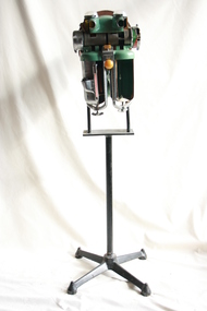
Machine - Coxeter-Mushin carbon dioxide absorber MK II, sectioned, c. 1945
The Coxeter-Mushin carbon dioxide absorber consists of the main metal body, painted aquamarine, fixed to a stand. The cylindrical silver metal cannister on the left was used to contain ether, while that on the right contained soda lime. The apparatus has been sectioned to show the inside of the two cannisters, the right of which has an arrow drawn inside to indicate the flow of air breathed out by a patient. The front cover over the control dials has also been removed to show the mechanism. The two circular holes above the dials, facing forward, are where two corrugated tubes would attach; both of these tubes attached to the mask of the patient. The round yellow knob in the centre controls the Compensating Valve, which allowed the anaesthetist to raise or lower the rebreathing bag to allow air into the circuit or expel anaesthetic gas.anaesthesia, carbon dioxide, ether, soda lime -
 Federation University Historical Collection
Book - Book - Ledger, Ballarat School of Mines Donation Book, 1978-1896, 01/01/1878 - 01/08/1896
Leather bound ledger with hand written details on donations to the Ballarat School of Mines Museum or the Ballarat School of Mines Library. The Ledger was made by J. McHutchison, Bookbinder, paper ruler and Account Book Manufacturer. 267. 07 July 1880 - John Lynch Junior - Smythesdale - Cast of "Golden Age" nugget found at Browns by Co-operative Party - 12 men. Weight 75 oz 12 dwts 12 grs 294. 24 June 1880 - W.H. Shaw - Ballarat - 94 numbers of 'The Engineer'. 295. 28 June 1880 - Rivett Henry Bland - Clunes - Specimen of water pipe from the Port Phillip Consols Mine encrusted with Carbonates of lime and magnesia and sulphate of lime with earthy matter. 418. 17 June 1881 - F. Ratte - Sydney - Catalogue of Rocks, minerals, etc of New Caledonia. 462. 28 September 1881 - Dr Bunce - Ballarat - Concretionary Basalt with Car. Lime and Magnesia. 465. 06 September 1881 - J.J. Sleep (Chairman of the Board) per favor of E.W. Spain, Esq, Manr - Ballarat - Diamond drill core from "Carisbrook Freehold Estate" - cut at a depth of 150 feet. Dedrites from Munster Gully ... 517. 20 January 1882 - William Lester - Ballarat - The Agricultural Teacher 549. 24 March 1882 - C.E. Grainger Manager Ballarat Woollen Mills - Ballarat - Samples of dyed and raw wool and dye material. 600. 04 July 1882 - Henry Sutton - Ballarat - 13th Annual Report of the Aeronautical Society of Great Britain. 1222. 31 October 1884 - Trooper Dowling - Miner's Rest - Owl 1223. 04 November 1884 - W. McKeenan - 3, Adair St, Ballarat - Flying Squirrel. 1259. 16 January 1885 - A.A. Buley - Ballarat - Prospective of Grenville College 1885 1428. 06 October 1885 - Ballarat - Collection of mineral specimens from Silverton (Collected by Mr James Murray). 1442. 20 October 1885 - Ballarat - Specimen of fossil fruits collected by Haddon by Charles Brown. 1682. 28 February 1887 - James Lamb - Ballarat - Copy of the Ballarat Times Newspaper of 3rd December 1854, framed and protected on both sides with glass. 1730. 23 May 1887 - Bella Guerin - Ballarat - Copy of the Victorian Review No 74 December 1885 4786. 27 March 1894 - James Oddie - Ballarat - 3 mineral specimens 4835. 01 August 1896 - P.V> Barnard - Ballarat - {ortion of Mining truck wheel altered to oxide of iron found in the old workings of the Golden Gate Mine at a depth of 200 feet. (4235 is last entry)ballarat school of mines, ballarat school of mines museum, donations, henry sutton, bella guerin -
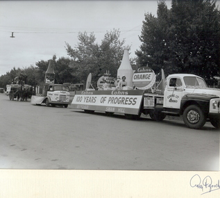 Bendigo Historical Society Inc.
Photograph - COHN BROS FLOAT, EASTER PARADE 1957, c.1957
Black and white photograph, in cream folder, of Easter Parade 1957, featuring Cohn Bros 100 years floats. Truck and tray carrying two females and display of Cohn's produce. Small truck with large model of tomato sauce bottle. Horse drawn wagon with bales of straw and male and remake figures. Inscriptions: in image - 'Cohn's Ltd, Bendigo', 'Cohn's 100 years of Progress', 'Bendigo, Swan Hill', Small advertising hoardings on large truck, something soft drinks. 'Say Cohn's please'. Lemonade, Pine Quench, Kola Beer, Lemon Quench, Ginger Beer, Raspberry Quench, Dry Ginger Ale, Grapefruit, Lime and Soda, Mandarin, 6 o'clock lager, Passionfruit. 'Quick and Quenchy'. On front cover BR cover printed 'Reg Brock of Bendigo'. On frame of image BR hand written 'Reg V Brock'. History: Previous Acc. No. MP200.Reg V Brockperson, group, easter procession? -
 Bendigo Historical Society Inc.
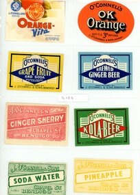
Document - VARIOUS DRINKS AND FOOD LABELS
Twenty eight drinks and food labels: J.O'Connell and Sons. Bendigo Prize Lemonade. J.O'Connell and Sons Bendigo Lime Flavor and Soda. D. Oswald Eaglehawk Hop Ale. XXXX Stout bottled by Glover and Son Chapel St. Bendigo. C.J. Glover Chapel St. Bendigo Ginger Punch. J.O'Connell Orange Vita - Ok Orange - Grapefruit and Soda - Brewed Ginger Beer - Ginger Sherry - Kola Beer - Soda Water - Pineapple. Dan Oswald tomato sauce. Glover and Son Tomato Soup. Qt Orange fruit Drops. Cottee's Sparkling Passiona. Lagoon Confection Long Toms. Bartlett Pears. The Bendigo Preserving Co. Golden Bar Orlean Plum Jam. Bendigo Preserving Co. Apricot Jam. Bendigo Preserving Co. Plum and Raspberry Jam. Golden Holme Apples. Rosella. Cottee's sparkling Drinks. Chocolate Cream Toffees. Lagoon Spearmint.business, retail -
University of Melbourne, Burnley Campus Archives
Album - Black and white and colour slides, Teaching Horticulture, 1952-1969
Large collection of slides used for teaching Horticulture. Difficult to identify whether they were taken at Burnley. Labelled and numbered 1-2501. Some dated but spread over 1950's to 1960's. Also 57 slides similar to 1-50 labelled but not numbered. Some photographs have been catalogued elsewhere. Missing numbers have been mixed up with other photographs. 1-50 Mostly fungal diseases. 57 slides not numbered - fungal diseases. 1-29 Mostly mosses. 31-41 Mostly liverworts and hornworts. 43-60 Ferns. 61-73 selaginella. 75-84 Ferns 85-114 Gymnosperms 115-1236 Miscellaneous 117-141 Angiosperms 142-294 Biology 296-307 Orchidaceae 311-316 Acacias 796-841 Trees 866-889 Roses 955-984 Eucalyptus 1009-1046 Greenhouse. 1052-1086, 1097-1152 Propagating fruit trees. 1087-1090 Cacti. 1151-1187 Planting and pruning principles. 1196-1218 Orchard, Nursery. 1211 June 1956. 1215 8/3/57. 1228-1258 Orchard Management. 1263-1345 Crafting and reworking. 1346-1373 Bulk handling. 1390-1400 Leaf scorch. 1424-1472 Vegetables.1473-1512 Potatoes, Research farm Toolangi 2/54. 1514-1686 Garden Design. 1688-1695 Cow Paddock, and in flood. 1958, Students. 1795-1798 P.R.I. 1823 Rolling the Surface (New Admin Building)1828-32.1831-1838 Beaumaris Feb 1958.1840-1846 P. Vejjajiva's Farewell 23.2.1958. Pruning Day 2/7/60. 1977-1990 Genetics. 1991-2018 Weeds. 2020-2-50 Erosion. 2023 10/65 and soil conservation. 2072-2136 Fertilizers. 2144-2149 Rhizobia 1950's. 2155-2157 Lime. 2160-2228 Plough, Cultivators, etc. 2246-2296 Tatura 12/59. 2301-2237 Beef and Dairy Cattle. 2338-2354 Sheep. 2355-2372 Crops. 2357-2363 1952. 2364 1958. 2373-2397 Fodder conservation 1952-1956. 2398-2411 Fences. 2398-2406 11/52. 2418-2248 Longerenong Field day 1964. 2451-2455 Boom Sprayer 1960. Glasshouse Wagga Agric College Oct 69. Apr 84 M3 16-18 Cultivator? 2458-2483 Hydraulics,Power Farming Dec 1966-Mar 1967. 2487-2488 Hydraulics Vane Pump Construction. 2491-2500 Mechanics. 2501 Rack Shaker. Extra 13 Pond life. Some slides see B18.0001: 1676, 1684, some between 1711-1792, 1881, some between 1911-1953.Not scanned yet.teaching, horticulture, greenhouse, propagation, pruning, cacti, planting, orchard nursery, orchard management, grafting and reworking, potatoes, toolangi, garden design, lagoon paddock, beaumaris excursion, p.vejjajiva, lagoon paddock in flood, fungal diseases, genetics, weeds, erosion, fertilizers, rhyzobia, lime, cultivation, tatura, cattle, sheep, crops, fodder, fences, hydraulics, mechanics, longerenong, cow paddock, plough, cultivator, boom sprayer, wagga agricultural college, vane pump -
 Federation University Historical Collection
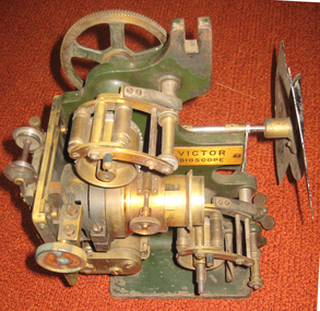
Equipment - Projector, Victor Bioscope, c1910
A Bioscope show was a fairground attraction consisting of a travelling cinema. The heyday of the Bioscope was from the late 1890s until World War I. Bioscope shows were fronted by the largest fairground organs, and these formed the entire public face of the show . A stage was usually in front of the organ, and dancing girls would entertain the crowds between film shows. Films shown in the Bioscope were primitive, and the earliest of these were made by the showmen themselves. Later, films were commercially produced. Bioscope shows were integrated, in Britain at least, into the Variety shows in the huge Music Halls which were built at the end of the nineteenth century. After the Music Hall Strike of 1907 in London, bioscope operators set up a trade union to represent them. There were about seventy operators in London at this point. (http://en.wikipedia.org/wiki/Bioscope_show) The Projector was a rather unreliable piece of apparatus, powered by a variety of light sources, including Calcium Oxide (Lime-Light). A Calcium Carbide Burner, or the rather more superior Carbon Arc. All these methods were highly unpredictable & quite frankly...dangerous! Often resulting in explosions, burning down the entire Show! (which is probably why NO original Shows still exist. Alfred Ball's Bioscope, pictured below, built in 1905 was struck by lightning, shortly after the picture was taken! (http://www.circus-entertainer.co.uk/heritage.htm) In 1909 the first bioscopes pictures were shown at the Ballaarat Mechanics' Institute.Brass and green painted metal film projectorbioscope, vector, entertainment, projector, film, theatre, movie -
 The Beechworth Burke Museum
Geological specimen - Dolomite
Dolomite is a mineral, calcium magnesium carbonate, with the chemical formula CaMg(CO3)2. It is a principle component of various rock types sometimes also referred to as dolomite, including dolostone, dolomitic marble and dolomitic limestone (according to the composition of each type). Dolomite rock is found in sedimentary basins throughout the world, comprising approximately 2% of the Earth's crust. It is formed when lime mud or limestone encounters groundwater containing magnesium. Dolomite can contain elements such as lead, zinc and copper. Dolomite and limestone are used in various construction, landscaping and agricultural processes. This specimen was donated to the Burke Museum in 1868 by Alfred Selwyn as part of the Geological Survey of Victoria. It was donated to the Museum in 1868. Victoria and other regions of Australia were surveyed for sites of potential mineral wealth throughout the 19th Century. The identification of sites containing valuable commodities such as gold, iron ore and gemstones in a locality had the potential to shape the development and history of communities and industries in the area. The discovery of gold in Victoria, for instance, had a significant influence on the development of the area now known as 'the goldfields', including Beechworth; the city of Melbourne and Victoria as a whole. Dolomite and limestone are mined at several locations in Victoria, including sites in the North-East of the state in Bindi and Limestone Creek. There are notable dolomite deposits in most Australian states. The dolomitised form of the mineral tends to come from older limestone deposits, formed during the palaeozoic era in marine settings, so this specimen may have come from a deposit located along a coastline in Victoria or another state. The specimen is significant as an example of surveying activity undertaken to assess and direct the development of the mineral resource industries in Victoria and Australia, as well as the movement to expand human knowledge of earth sciences such as mineralogy and geology in the nineteenth century. This specimen is part of a larger collection of geological and mineral specimens collected from around Australia (and some parts of the world) and donated to the Burke Museum between 1868-1880. A large percentage of these specimens were collected in Victoria as part of the Geological Survey of Victoria that begun in 1852 (in response to the Gold Rush) to study and map the geology of Victoria. Collecting geological specimens was an important part of mapping and understanding the scientific makeup of the earth. Many of these specimens were sent to research and collecting organisations across Australia, including the Burke Museum, to educate and encourage further study.Hand-sized piece of pale pink dolomite (calcium magnesium carbonate) with dark grey rim and hollowed centre. geological specimen, geology, geology collection, burke museum, beechworth, dolomite, mineralogy, geological survey, alfred selwyn, limestone, calcium magnesium carbonate -
 Nepean Historical Society
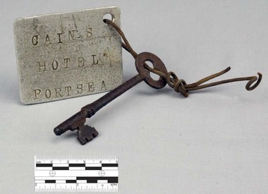
Functional object - Key with Tag
This object features a key with a labelled tag attached to it. It was once the key to the well-known Nepean Hotel. Also known locally as 'The Castle', likely due to its grand size and turret-like tower, the Nepean Hotel was officially established in 1872 by James Sandle Ford (https://poi-australia.com.au/points-of-interest/australia/victoria/portsea/approximate-site-ford-family-nepean-hotel-c-1870-pt-nepean-rd-near-fitzjohns-crt-portsea-mornington-peninsula-vic/). Born in 1811, Ford was only nineteen years old when he was sentenced to seven years transportation for 'Machine Breaking' in 1830. (https://nepeanhistoricalsociety.asn.au/james-sandle-ford/). He arrived in Van Diemen's Land (Tasmania) in 1831 and served five years of his sentence, before being pardoned in 1836. Ford met and married Irish immigrant Hannah Sullivan in 1841 in Sydney. The following year, the couple settled in Point Nepean. Ford is often accredited with the naming of the town of Portsea - after Portsea in Hampshire, UK - and spent a lifetime establishing himself throughout the area. This included: lime burning, dairying, horse judging and breeding, and the cultivation of land and livestock. Ford died in 1890, however his hotel continued to operate for many decades, run by his descendants - including Julia Cain during the first half of the twentieth century (https://trove.nla.gov.au/newspaper/article/65817831) (https://trove.nla.gov.au/newspaper/article/3734533). The hotel was demolished in 1971. This object is significant as it is important in relation to the development and prosperity of the area of Point Nepean. A door key with a rusted surface. One end of the key features a single set of teeth with three notches. Attached to the other end is a rounded handle with a hole through the middle. Looped through the hole is a piece of thin, rusted wire. The wire is looped through both the key and a hole in a white square-shaped tag. Printed on the tag are the words: 'CAIN'S HOTEL PORTSEA'. CAIN'S HOTEL, PORTSEAnepean hotel, cain family, james ford, james sandle ford, portsea hotel -
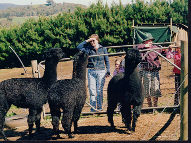
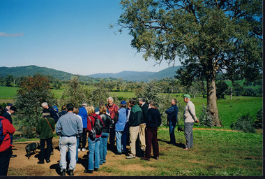 Wooragee Landcare Group
Photograph, 5 September 2004
This photograph was taken at Samaria Farm on Sunday the 5th of September as part of a day trip by the Wooragee Landcare Group. The event was about looking at land use on small farms and as a social get-together for the Group. Wooragee Landcare was also researching how small landholders could run some enterprises around the time of this trip. Samaria Farm is located in northeast Victoria, near Mount Samaria, which is located 130 km northeast of Melbourne. Samaria Farm was owned by Sue and Due Matheson at the time of the trip and had a renowned rose garden, pigs, poultry, alpacas, and goats on their nine-hectare farm. The rose garden consists of 3000 damask roses. Samaria Farm distils the oil from these roses and is the only farm in Australia to do this. Rose oil has historically been used for religious and medical use. 20 kg of rose buds are picked by hand every day, which is then distilled and produced 5 to 8 ml of oil. The entire four-week season produces 80 to 100 ml of oil. Rose water is also created during this process and produces about 300 litres per season. Along with the oil, the Farm also harvests lemons, lime, olives, and oranges. The Farm is currently owned by Utako and Anthony since 2022, with Vicki and Allan Wight being the previous owners. Wooragee Landcare Group was created in 1988. Its core mission is to work towards eradicating animals and pests from the land to protect the natural vegetation and promote revegetation projects. This photograph is a great example of the type of events that Wooragee Landcare Group has organized, while educating the public about the importance of land use management. The group is important to the community and for the environment.Landscape coloured photograph printed on gloss paperReverse: WAN NA E0NA2N2. NNN+ 2 4240/ [PRINTED] (No. 18) / 371samaria farm, wooragee, wooragee landcare group, wooragee landcare's collection, samaria, small farm, land use, social, rose oil, damask roses, pests -
 Wooragee Landcare Group
Photograph, 5 September 2004
This photograph was taken at Samaria Farm on Sunday the 5th of September as part of a day trip by the Wooragee Landcare Group. The event was about looking at land use on small farms and as a social get-together for the Group. Wooragee Landcare was also researching how small landholders could run some enterprises around the time of this trip. Samaria Farm is located in northeast Victoria, near Mount Samaria, which is located 130 km northeast of Melbourne. Samaria Farm was owned by Sue and Due Matheson at the time of the trip and had a renowned rose garden, pigs, poultry, alpacas, and goats on their nine-hectare farm. The rose garden consists of 3000 damask roses. Samaria Farm distils the oil from these roses and is the only farm in Australia to do this. Rose oil has historically been used for religious and medical use. 20 kg of rose buds are picked by hand every day, which is then distilled and produced 5 to 8 ml of oil. The entire four-week season produces 80 to 100 ml of oil. Rose water is also created during this process and produces about 300 litres per season. Along with the oil, the Farm also harvests lemons, lime, olives, and oranges. The Farm is currently owned by Utako and Anthony since 2022, with Vicki and Allan Wight being the previous owners. Wooragee Landcare Group was created in 1988. Its core mission is to work towards eradicating animals and pests from the land to protect the natural vegetation and promote revegetation projects. This photograph is a great example of the type of events that Wooragee Landcare Group has organized, while educating the public about the importance of land use management. The group is important to the community and for the environment. Landscape colored photograph printed on gloss paperReverse: WAN NA E0NA2N2. ANN+ 1 4240/ [PRINTED] (No. 19) / 372samaria farm, wooragee landcare group, wooragee, victoria, mount samaria, farming, roses, rose oil, damask roses, agriculture, pests, vegetation -
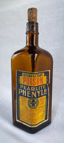 City of Moorabbin Historical Society (Operating the Box Cottage Museum)
Container - Pearlite Phenyle Bottle
Pearlite Phenyle was manufactured by Renown Pearlite Company Pty Ltd, which was formerly known as Pearlite Manufacturing Company. The factory was in 171-177 Stawell Street, Richmond and they manufactured kitchen products essence, Sunflakes - breakfast cereal.4 sided, diamond-shaped amber glass Phenyle bottle with cork stopper and paper label printed in blue, red, and yellow.Disinfectant – Poison – Pearlite Phenyle Poisonous not to be taken Contents 20 Fluid ozs Renown & Pearlite Pty Ltd DIRECTIONS FOR USE 2 teaspoonfuls to 1 pint of water 1 pint to 6 Gallons of water Does not contain more than 3 per cent or less than 2 pre cent or Carbolic or its homologue. Guaranteed to destroy Typhoid Fever Bacillus, 1 part fluid 30 parts water, in 10 minutes. NOTE – Placing the disinfectant in copper vessels or in contact with Alkaline Substances renders it imperative. ANTIDOTE: Epsom or Glauber salts in water. Lime water and olive oil or castor oil (Perlite for Preference) EMBOSED ON BOTTLE: Phenyle with XX’s – poisonous – this bottle is the property of – 2140 STICKER: Sold by Crofts Stores Pty Ltd Branch Store: Hawthorn Road Caulfield. phenyle, bottle, cleaning, disenfectant -
Federation University Historical Collection
Tool - Object, E. Thomas & Williams Limited, Cambrian Lampworks, Kop Staszic Carbide Lamp
Carbide lamps, or acetylene gas lamps, are simple lamps that produce and burn acetylene (C2H2) which is created by the reaction of calcium carbide (CaC2) with water. Acetylene gas lamps were used to illuminate buildings, as lighthouse beacons, and as headlights on motor-cars and bicycles. Portable acetylene gas lamps, worn on the hat or carried by hand, were widely used in mining in the early twentieth century. A mining or caving lamp has calcium carbide placed in a lower chamber, the generator. The upper reservoir is then filled with water. A threaded valve or other mechanism is used to control the rate at which the water is allowed to drip into the chamber containing the calcium carbide. By controlling the rate of water flow, the production of acetylene gas is controlled. This, in turn, controls the flow rate of the gas and the size of the flame at the burner, and thus the amount of light it produces. Staszic is a coal mine located in Katowice , in the district Giszowiec, Poland This type of lamp generally has a reflector behind the flame to help project the light forward. An acetylene gas powered lamp produces a bright, broad light. Many cavers prefer this type of unfocused light as it improves peripheral vision in the complete dark. The reaction of carbide with water produces a fair amount of heat independent of the flame. In cold caves, carbide lamp users can use this heat to help stave off hypothermia. When all of the carbide in a lamp has been reacted, the carbide chamber contains a wet paste of slaked lime (calcium hydroxide). This is emptied into a waste bag and the chamber can be refilled. (http://en.wikipedia.org/wiki/Carbide_lamp, accessed 06/05/2015)Metal Carbide Mining lamp with light reflector and hook.miners lamp, mining lamp, statszic, poland, carbide, mining -
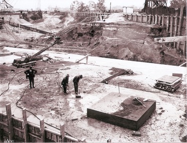 Wodonga & District Historical Society Inc
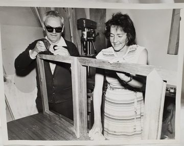
Album - Hume Reservoir Australia Album - Preparing a paddock for concrete. August 1927
This set of photos is from a leather bound album bearing the inscription "HUME RESERVOIR AUSTRALIA" plus 'The Rt. Hon. L. C. M. S. Amery, P. C., M .P.' all inscribed in gold. It was presented to The Rt. Hon. L. C. M. S. Amery, P. C., M. P, Secretary of State for Dominion Affairs on the occasion of his visit to the Hume Reservoir on 2nd November 1927. This album is of local and national significance as it documents the planning and development of the Hume Reservoir up to 1927. It was the largest water reservoir in the British Empire. The album records the pioneering engineering work that went into its construction.DEPARTMENT OF PUBLIC WORKS, N.S.W. RIVER MURRAY WATERS SCHEME. HUME RESERVOIR. 27. Preparing a Paddock for Concrete. Great care is taken in cleaning the surface of the concrete before placing the next layer. A hose applies a jet of water with a pressure of about 150 pounds to remove laitance and all dirt, which is swept off with brooms. (Laitance is the weak, milky or powdery layer of cement dust, lime and sand fines that appear on the surface of concrete. ) The square block of concrete in the foreground is poured at the same time as the concrete surrounding it and acts as a key for the next layer. Usually large granite “plums” or displacers weighing from 2 tons to 8 tons are used for this purpose and are placed in position by the cableway, but while the cableway is out of action the other method has been adopted. In this view may also be seen some of the timber piles and sheeting which form the inner side of the coffer dam. The outer side is formed of steel sheet piling. The space between the two lines of piles is 20 feet wide and is filled with earth after the steel and timber lines have been bound together by steel tie rods. New South Wales, August 1927.hume reservoir australia, river murray waters scheme, hume reservoir construction -
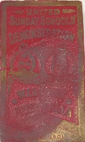 Kew Historical Society Inc
Souvenir, United Sunday schools, Red Leather Bookmark, United Sunday Schools' Demonstration, Melbourne, 6 May 1901, 1901
SUNDAY SCHOOL DEMONSTRATION. With three times three we coo-ee, The Prince we meet again; Our Princess May we welcome, With heart and voice amain. This was the welcome of the children of the Melbourne Sunday schools. The greeting came from over 30,000 youthful voices to the accompaniment of as many waving flags of diminutive size, held by the children. Probably not one of those who sang so lustily had witnessed the previous visit of his Royal Highness; or knew anything of it except as a traditional event, but the sentiment was a good and proper one all the same. The children were massed on the rising ground in the Domain, and apparently the long wait was not at all wearying. It was to most of them a huge picnic. They lunched on the grass, and filled in the intervening lime with games such as the juvenile heart delights in. At intervals something approaching order, was observed, and then songs, which have been in rehearsal for some weeks past, were sung under the baton of Mr. D. R. Davies, musical director, and to the lead of a united brass band of over a hundred instrumentalists under Bandmaster E; T. Code. A solo was also sung by Mr. H. J. Floyd. At all times the scene was an exceedingly animated one. Most of the children were attired in light costumes, and those in whose dress there was some color provided the necessary variety to make up a most picturesque scene. Probably there were nearly 35,000 adults and children at this spot. They occupied the frontage to St. Kilda-road, from Government House gates to the intersecting thoroughfare beyond. As the children were confined to the high ground, there was a green strip in front of them, and the dark green of the fir trees at the top of the slope made a most suitable background. Between these two lines of even coloring the children, with the easy freedom of youth, made perhaps as pretty a feature of the pageant as could be found anywhere in the whole route of the procession." (The Age, Tues 7 May 1901, p.6)This tiny battered piece of ephemera recording the United Sunday School Demonstration of 1901 must once have been exceedingly common, however in the context of the growing collection that the Society has relating to the opening of the first Commonwealth Parliament in Melbourne it has historic and social significance.Embossed red leather bookmark commemorating the 'United Sunday Schools Demonstration' in St Kilda Road in 1901 to welcome the Prince and Princess of Wales to open the first Commonwealth Parliament in the Royal Exhibition Building."United Sunday Schools Demonstration, Melbourne Australia, Melbourne May 6 1901"opening of the first commonwealth parliament - 1901, sunday schools - victoria, federation events - victoria - 1901, ephemera -
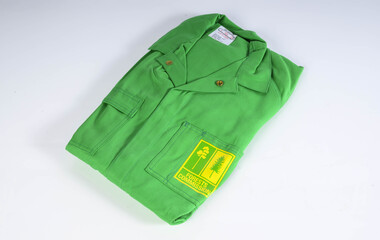 Department of Energy, Environment and Climate Action
Protective Bushfire overalls
At the time of the 1982-83 bushfire season FCV firefighters wore either navy blue issue overalls or their own clothing, generally a checked flannel shirt and jeans. Uncomfortable safety boots and hardhats were issued. The CFA had switched from white overalls to their distinctive yellow kit by 1983. In about 1980, in a far-sighted corporate move for the time, Alan Threader, who was the Chairman of the FCV, established a departmental safety committee, which he personally chaired. The Committee, among other things, wanted to upgrade fire safety clothing. Alan also initiated a radical colour idea after a work trip to the UK in about 1981 and brought home a small sample swatch. Alan believed that the now distinctive bright yellow-green was a good colour contrast to the Victorian bush which is a blue-green hue. Trevor Brown from Stores Branch scored the task to make the change and letters were sent to the UK seeking information about the pigment. The FCV worked with the Commonwealth Dyers Association and Cushen Clothing to replicate the shade on cotton drill, which presented darker when it was treated with the flame-retardant chemical, Proban. The first of the new Kermit Suits were rolled-out in late 1984, and the stylish colour was initially registered and patented to the Department. But it's also fair to say that the new gaudy shade of apparel wasn’t universally popular with staff. The lime green overalls were an Australian first, and forest agencies in other states followed a few years later. In the early 1990s, armed with a pair of dressmaker’s scissors, the baggy one-piece Kermit boilersuits were tailored by Peter Billing from Fire Protection Branch and Trevor Brown in conjunction with the family-owned business, Top Level Workwear, which saw numerous enhancements and prototypes. The two-piece Kermit suits were available in the late 1990s after many years of argy-bargy and complaints from field firefighters. Protective overalls Two types - early FCV (c 1983) and later CNR (1992) forests commission victoria (fcv), protective clothing, safety equipment -
 Monbulk Historical Society
Thomas and Lillian Cavey with sons Tom and George
Thomas William Cavey was born in 1871, he was the youngest of his family and the only child that was born in Australia. He was first employed at the lime kilns in Geelong, before moving to Queensland for 4 years where he worked as a Boundary Rider. Thomas returned to the Lilydale area to be the driver of a buggy and pair for David Mitchell of David Mitchell Quarry in Lilydale. He selected land in Seamer Road in Monbulk in about 1898, but was working for the railways in Melbourne at the time and would come up to Monbulk at weekends to clear and cultivate the land. He met Lillian Eager, probably through relatives of hers, the Wingates, who lived in Monbulk. He and LIllian were married in 1910. They bought a 22 acre property in what is now called Cavey Road. They had two sons Thomas Charles, born in 1918 and George William Born in 1923. Initially the property in Cavey Road was farmed for vegetables, fruit and berries. The land used for this was over a creek on steep land away from the house. Once the produce was harvested it was taken by flying fox, back across the creek to where it could be prepared for sale. It was then taken to the Emerald and Belgrave markets each week. Later 10 cows were purchased, and the main income from the property was the dairy which produced approximately 25 quarts of milk a day, they produced Cream and Butter and together with the milk they were delivered fresh daily in the horse and cart. Deliveries were made to Monbulk, The Patch and to the canvas town at Silvan Dam, where the workers building the Silvan Dam lived. Thomas William Cavey died in 1959 aged 89. Lillian Blanche Cavey died in 1949 aged 68. -
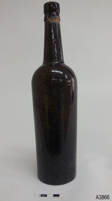 Flagstaff Hill Maritime Museum and Village
Container - Bottle, 1840s to 1910
This handmade ‘gallon’ style of bottle was generally used for storing and transporting wine and ale. Many bottles similar to this one have their bases embossed with “6 TO THE GALLON”. It is one of many artefacts recovered from unidentified shipwrecks along Victoria’s coast between the late 1960s and the early 1970s. It is now part of the John Chance Collection. The capacity of this is one-sixth of a gallon (imperial measure), which is equal to 758 ml. (American bottles were often inscribed “5 TO THE GALLON”, which is one-fifth of an American gallon, equal to 757 ml.) Contemporary home brewers can purchase new ‘6 to gallon’ bottles that hold 750 ml. and are sold in cases of 36 bottles, which is equal to 6 gallons of wine. Glass was made thousands of years ago by heating together quartz-sand (Silica), lime and potash. Potash was obtained from burnt wood, but these days potash is mined. The natural sand had imperfections such as different forms of iron, resulting in ‘black’ glass, which was really dark green or dark amber colour. The ‘black’ glass was enhanced by residual carbon in the potash. Black glass is rarely used nowadays but most beer, wine, and liquors are still sold in dark coloured glass. Glass vessels were core-formed from around 1500 BC. An inner core with the vessel’s shape was formed around a rod using a porous material such as clay or dung. Molten glass was then modelled around the core and decorated. When the glass had cooled the vessel was immersed in water and the inner core became liquid and was washed out. Much more recently, bottlers were crafted by a glassblower using molten glass and a blow pipe together with other hand tools. Another method was using simple moulds, called dip moulds, that allowed the glass to be blown into the mould to form the base, then the glassblower would continue blowing free-form to shape the shoulders and neck. The bottle was then finished by applying a lip. These moulded bottles were more uniform in shape compared to the free-form bottles originally produced. English glassblowers in the mid-1800s were making some bottles with 2-piece and 3-piece moulds, some with a push-up style base, sometimes with embossing in the base as well. Improvements allowed the moulds to also have embossed and patterned sides, and straight sided shapes such as hexagons. Bottles made in full moulds usually displayed seam seams or lines. These process took skill and time, making the bottles valuable, so they were often recycled. By the early 20th century bottles were increasingly machine made, which greatly reduced the production time and cost. This bottle is historically significant as an example of a handmade, blown inscribed glass bottle manufactured in the mid-to-late 1800s for specific use as a liquor bottle with a set measurement of one-sixth of gallon. It is also historically significant as an example of liquor bottles imported into Colonial Victoria in the mid-to-late 1800s, giving a snapshot into history and social life that occurred during the early days of Victoria’s development, and the sea trade that visited the ports in those days. The bottle is also significant as one of a group of bottles recovered by John Chance, a diver in Victoria’s coastal waters in the late 1960s to early 1970s. Items that come from several wrecks have since been donated to the Flagstaff Hill Maritime Village’s museum collection of shipwreck artefacts by his family, illustrating this item’s level of historical value. Bottle, brown glass, handmade. Tall slim Gallon style liquor bottle. Applied, double collar lip; square upper with flared lower. Neck has seams and shoulder seam from 3-piece mould. Body with horizontal ripples tapers inwards to base. Push-up base with pontil mark and embossed inscription. Tape over wire around mouth. Cork remnants inside mouth. Embossed on base "6 TO THE GALLON"flagstaff hill, warrnambool, flagstaff hill maritime museum, maritime museum, shipwreck coast, flagstaff hill maritime village, great ocean road, shipwreck artefact, john chance, glass bottle, antique bottle, gallon bottle, 6 to the gallon bottle, handmade, dip mould, mouth blown, pontil mark, blown bottle, liquor bottle, ale bottle, double collar, 19th century bottle, collectable -
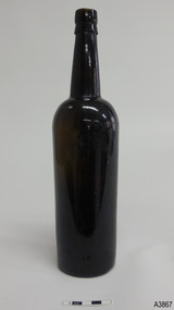 Flagstaff Hill Maritime Museum and Village
Container - Bottle, 1840s to 1910
This handmade ‘gallon’ style of bottle was generally used for storing and transporting wine and ale. Many bottles similar to this one have their bases embossed with “6 TO THE GALLON”. It is one of many artefacts recovered from unidentified shipwrecks along Victoria’s coast between the late 1960s and the early 1970s. It is now part of the John Chance Collection. The capacity of this is one-sixth of a gallon (imperial measure), which is equal to 758 ml. (American bottles were often inscribed “5 TO THE GALLON”, which is one-fifth of an American gallon, equal to 757 ml.) Contemporary home brewers can purchase new ‘6 to gallon’ bottles that hold 750 ml. and are sold in cases of 36 bottles, which is equal to 6 gallons of wine. Glass was made thousands of years ago by heating together quartz-sand (Silica), lime and potash. Potash was obtained from burnt wood, but these days potash is mined. The natural sand had imperfections such as different forms of iron, resulting in ‘black’ glass, which was really dark green or dark amber colour. The ‘black’ glass was enhanced by residual carbon in the potash. Black glass is rarely used nowadays but most beer, wine, and liquors are still sold in dark coloured glass. Glass vessels were core-formed from around 1500 BC. An inner core with the vessel’s shape was formed around a rod using a porous material such as clay or dung. Molten glass was then modelled around the core and decorated. When the glass had cooled the vessel was immersed in water and the inner core became liquid and was washed out. Much more recently, bottlers were crafted by a glassblower using molten glass and a blow pipe together with other hand tools. Another method was using simple moulds, called dip moulds, that allowed the glass to be blown into the mould to form the base, then the glassblower would continue blowing free-form to shape the shoulders and neck. The bottle was then finished by applying a lip. These moulded bottles were more uniform in shape compared to the free-form bottles originally produced. English glassblowers in the mid-1800s were making some bottles with 2-piece and 3-piece moulds, some with a push-up style base, sometimes with embossing in the base as well. Improvements allowed the moulds to also have embossed and patterned sides, and straight sided shapes such as hexagons. Bottles made in full moulds usually displayed seam seams or lines. These process took skill and time, making the bottles valuable, so they were often recycled. By the early 20th century bottles were increasingly machine made, which greatly reduced the production time and cost. This bottle is historically significant as an example of a handmade, blown inscribed glass bottle manufactured in the mid-to-late 1800s for specific use as a liquor bottle with a set measurement of one-sixth of gallon. It is also historically significant as an example of liquor bottles imported into Colonial Victoria in the mid-to-late 1800s, giving a snapshot into history and social life that occurred during the early days of Victoria’s development, and the sea trade that visited the ports in those days. The bottle is also significant as one of a group of bottles recovered by John Chance, a diver in Victoria’s coastal waters in the late 1960s to early 1970s. Items that come from several wrecks have since been donated to the Flagstaff Hill Maritime Village’s museum collection of shipwreck artefacts by his family, illustrating this item’s level of historical value. Bottle, brown glass, handmade. Tall slim Gallon style liquor bottle. Applied double collar lip; square upper with flared lower. Push-up base with pontil mark and embossed inscription. Base is uneven, glass composition has imperfections.Embossed on base "6 TO THE GALLON"flagstaff hill, warrnambool, flagstaff hill maritime museum, maritime museum, shipwreck coast, flagstaff hill maritime village, great ocean road, shipwreck artefact, john chance, glass bottle, antique bottle, gallon bottle, 6 to the gallon bottle, handmade, dip mould, mouth blown, pontil mark, blown bottle, liquor bottle, ale bottle, double collar, 19th century bottle, collectable