Showing 229 items
matching loddon
-
 Bendigo Historical Society Inc.
Map - DERBY : COUNTY OF BENDIGO, 1959
Map. Derby, County of Bendigo, Inglewood, Tarnagulla, Woodstock, Leichardt, Bridgewater, Loddon River, Bendigo Railway, Calder Highway, Maldon to Bridgewater Road.By authority A.C. Brooks, Government Printer, Melbourne. Drawn and reproduced at the Department of Lands and Survey, Melbourne, 1959. Price 5/-. (number 59 in map cupboard 1)A.C. Brooks, Government Printer, Melbourne.map, bendigo, derby -
Bendigo Historical Society Inc.
Map - SALISBURY WEST : COUNTY OF BENDIGO, 3-3-1944
Map. Salisbury, County of Bendigo, County of Gladstone, Powlett, Yarrayne, Bridgewater, Inglewood, River Loddon, Bullabul Creek, Glenalbyn, Kurting. By Authority H.E. Daw, Government Printer, Melbourne. Drawn and reproduced at the Department of Lands and Survey, Melbourne., 3-3-1944. Price 5/-. (number 94 in map cupboard 1)H.E. Daw, Government Printer, Melbourne.map, bendigo, salisbury west -
Bendigo Historical Society Inc.
Tool - INDIGENOUS STONE TOOL COLLECTION: DARK GREY STONE AXE HEAD
Dark grey to black stone axe head. Finely shaped and smoothed with knapped edge on longer end. Sides are bevelled off. This axe is markedly different to other artefacts in this collection. No provenance but was in a collection of stone tools found in the Axedale, Strathfieldsaye and Loddon regions. Further research required, could be Mt. William greenstone. -
Bendigo Historical Society Inc.
Map - SALISBURY WEST : COUNTY OF BENDIGO, 24-6-24
Map. Salisbury, County of Bendigo, County of Gladstone, Powlett, Yarrayne, Bridgewater, Inglewood, Glenalbyn, Kurting, River Loddon, Bulabul Creek. By authority A.J. Mullett, Government Printer, Melbourne. Photo-Lithographed at the Department of Lands and Survey, Melbourne by W.J. Butson, 24-6-24. Price 1/-. (number 116 in map cupboard 1)A.J. Mullett, Government Printer, Melbourne.map, bendigo, salisbury west -
 Bendigo Historical Society Inc.
Photograph - HARRY BIGGS COLLECTION: D. COGHILL AND SONS
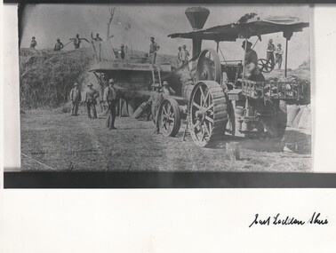
Copy of a photograph of a group of men using a threshing machine, the name D. Coghill and sons is written on the machine. There is one man seated on the traction engine and six other men standing. There is a large pile of hay at the rear of the machine with ten men standing on the stack, most of the men are holding pitchforks. East Loddon Shire is written on the base of the phototopic, farming, threshing, traction engine, threshing machine, d. coghill and sons -
 Bendigo Historical Society Inc.
Photograph - HARRY BIGGS COLLECTION: SHEARING SHED
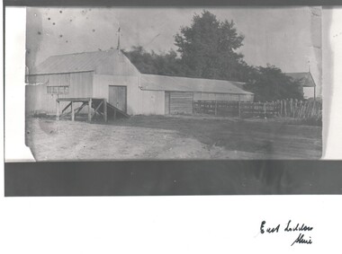
B&W Photograph of a shearing shed, with a wooden extension, there are sheep yards off to the side of the extension. There is a weather vane attached to the gable, there are trees in the background. Another shed with a weather vane can be seen behind the trees. A ramp extends upwards from a door in the end of the shed. The words 'East Loddon Shire' are written at the bottom of the Photoplace, building, shearing shed, east loddon shire, shearing shed -
 Bendigo Historical Society Inc.
Photograph - HARRY BIGGS: STABLES ON GODGREYS HOMESTEAD
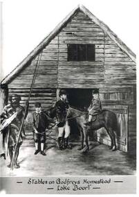
Black and white photo of Mr Henry Godfrey and his sons along with Prince Charlie of the Jajoweroung or Loddon Tribe. The group are standing in front of wooden stables with a window in the roof above the open door. One son is on a horse and the other is holding the reins. The boys are both wearing hats and are dressed in stockings and breeches. Mr Godfrey is the background wearing a hat riding boots, breeches and a 3/4 coat. In the front to the left is Prince Charlie holding two spears and is in native costume. At the bottom of the photo written in black ink is: Stables on Godfreys Homestead - Lake Boort - On the back of the Photo is written in clue Ink "Stables on Godfrey's Boort Homestead, Lake Boort, November 1863. W. Henry Godfrey and his sons, with "Prince Charlie" of the jajoweroung or Loddon Tribe.photo, group, godfreys homestead, stables on godfreys homestead, lake boort, prince charlie, henry godfrey and his sons. -
 Bendigo Historical Society Inc.
Document - MANUSCRIPT: THE ''HISTORY OF OLD INGLEWOOD'' (NO ACTUAL TITLE)
Thirty paged manuscript re the ''History of old Inglewood'' (No actual title or stated author. The 'Preface' (last page) states that in 1961 the town would celebrate its centenary and, also, that it lost its official identity (amalgamation with the Shire of Korong). Comprises:Introduction; Aboriginal life and early history of interaction with settlers; Major Mitchell exploration in area (''Yarrayne'' as name given for the Loddon; Mt Korong - aboriginal ''Barrabungale''); Pioneers on the Loddon - land tenure (Order of Council 1847), ref to Simson (Donald Campbell; Hector Norman); Charlotte Plains (run); John Catto (of Loddon) and John Catto (of Berlin); William Allen; Alexander Moffat Allen; Mr Sellars; 1852 gold rush to Mt Korong (surface); 1859 discovery of gold at Inglewood ( A J Thompson, T Thompson, T Harvey); detail of gold mining in Inglewood; Borough of Inglewood (1863); growth of the town - hotels, banks, newspapers; 1863 fire in township; fire brigade at Inglewood; selection of land; the ''Land Convention''; the ''Duffy Act''; land selection; 'modern' developments in Inglewood(rail, gas); Jack Donaldson - runner 100 yds sprint title; armed services involvement of Inglewood (WW1 & WW2); government departments.inglewood, history, early history, lodden, mt korong, donald campbell, hector norman, inglewood fire brigade, duffy act, jack donaldson, alexander moffat, john catto, major mitchell, ww1, ww2. aboriginal life, order of council 1947. -
 Ballarat Heritage Services
Photograph - Image, Guildford, Victoria, 1867
Black and white image of Guildford, near Castlemaine, VictoriaGUILDFORD Is a small township situated at the junction of Campbell's Creek and the Loddon. It is about seven miles from Castlemaine, on the road from that town to Ballaarat and Daylesford. The land near the Loddon is very rich, and as a large number both of theoretical and practical miners believe that a rich goldfield underlies the surface basalt, there is every probability of Guildford being ere an important goldfield. A large area of land in the neighbourhood has been already worked, principaIy by Chinamen, who until very recently mustered in great force in the locality. (Illustrated Adelaide Post, 23 March 1867)guildford, loddon river -
Bendigo Historical Society Inc.
Map - NERRING : COUNTY OF BENDIGO, August 1952
Map. Nerring, County of Bendigo, Yarraberb, Leichardt, Marong, Sandhurst, Huntly, Neilborough, Bendigo and Swan Hill Railway, Bendigo and Kulwin Railway, Loddon Valley Highway. By authority J.J. Gourley, Government Printer, Melbourne. Drawn and reproduced at the Department of Lands and Survey, Melbourne, Victoria. August 1952. Price $1.00. (number 76 in map cupboard 1)J.J. Gourley, Government Printer, Melbourne.map, bendigo, nerring -
Bendigo Historical Society Inc.
Map - POWLETT : COUNTY OF BENDIGO, 2-12-15
Map. Powlett, County of Bendigo, County of Gladstone, Janiember West, Janiember East, Yarrayne, Salisbury West, Kurting, Korong, River Loddon. By Authority Albert J. Mullett, Government Printer, Melbourne. Photographed at the Department of Lands and Survey, Melbourne by W. J. Butson.2-12-15. Price 1/-. (number 119 in map cupboard 1)Albert J. Mullett, Government Printermap, bendigo, powlett -
Bendigo Historical Society Inc.
Tool - INDIGENOUS STONE TOOL COLLECTION: AXEDALE AREA STONE AXE HEAD
Dark grey, very hard stone, knapped at one end to sharp edge. Number '8' stuck on stone with tape. Interpretive sign with stone reads ' Stone age implements, exhibits 6 - 10, all found near Axedale, Victoria. Stone axe heads, compare these with a selection of axe heads from the banks of the Loddon, Exhibits 11 - 13' -
 Bendigo Historical Society Inc.
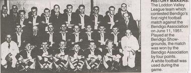
Newspaper - JENNY FOLEY COLLECTION: HISTORY MAKERS
BHS CollectionBendigo Advertiser ''The way we were'' from Monday, December 6, 2004. History makers: the Loddon Valley league team which contested Bendigo's first night football match against the Bendigo Association on June 11, 1951. Played at the Bendigo Showgrounds, the match was won by the Bendigo Association by four points. A white football was used during the game.newspaper, bendigo advertiser, the way we were -
 Bendigo Historical Society Inc.
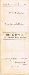
Document - CONNELLY, TATCHELL, DUNLOP COLLECTION: DOCUMENT
Deed of Covenant and Extension of Term of Mortgage, dated 11 August 1899 between Thomas Francis Moylan of Loddon Vale and William Fairclough, Bank of Victoria London and Gilbert Wilson Brown, Mathoura Raod, Toorak extend the Mortgage until the 16 August 1902. Orange Victoria One Penny Duty Stamp attached. Small red seal next to signature.business, legal, connelly & tatchell, connelly & tatchell collection - document, deed of covenant and extension of term of mortgage, connelly tatchell & dunlop, thomas francis moylan, william fairclough, bank of victoria london, gilbert wilson brown, davidson, j b young -
Bendigo Historical Society Inc.
Map - JANIEMBER EAST : COUNTY OF BENDIGO, 15-1-34
Map. Janiember East, County of Bendigo, Jarklan, Pompapiel, Yarrayne, Powlet, Janiember West, Serpentine Creek, Caney's Blind Creek Long Plain Creek, Loddon River. By authority : H.J. Green, Govt. Printer, Melbourne. Drawn and reproduced at the Department of Lands and Survey, Melbourne, Victoria. Price 2/-. 15-1-34. (number 45 in map cupboard 1)H.J. Green, Govt. Printer, Melbourne.map, bendigo, janiember east -
Bendigo Historical Society Inc.
Tool - INDIGENOUS STONE TOOL COLLECTION: AXE HEAD OR SCRAPER, AXEDALE AREA
Brown stone, has slight granite appearance. Short edge knapped to provide a sharp edge. Number 10 stuck on stone with tape. Interpretive sign with item reads' Stone Age Implements, exhibits 6 - 10, all found near Axedale, Victoria. Stone Axe heads ( compare these with a selection of Axe Heads from the banks of the Loddon, Exhibits 11 - 15) -
 Bendigo Historical Society Inc.
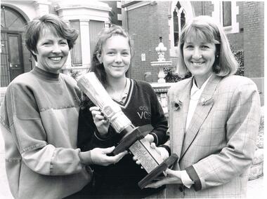
Photograph - BENDIGO ADVERTISER COLLECTION: SPORTS STAR AWARDS PRESENTATIONS, 9/11/93
Black and white photograph, multiple people, photograph of Helen Ward, Sally Reynolds and Maxine Crouch in front of the Bendigo CCB Catherine McAuley College Bendigo Advertiser description: 9/11/93 ALP SPORTS AWARDS WINNERS Helen Ward 8 Loddon Valley Netball League Sally Reynolds, 16, Tumbler Maxine Crouch Pres of BGO Sportswomens Associationrecreations, sports, awards -
NMIT (Northern Melbourne Institute of TAFE)
Book: Furniture and equipment layouts for TAFE colleges Victoria. 1981
A4 size loose pages published by the Public Works Department and the Education Department Victoria in 1981. The contents cover the following Colleges: Moorabin, Dandenong, Collingwood, Newport, Box Hill, Sunraysia, Yallourn, Footscray, RMIT, Preston, School of Mines & Industries Ballarat, McMillan Rural Studies, Loddon Valley Bendigo, Wangaratta and Latrobe Street Complex. Plans and diagrams included.manuals, tafe colleges, preston technical college, collingwood tedhnical college, nmit -
 Ballarat Heritage Services
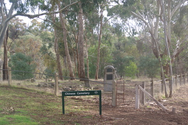
Photograph - Colour, Vaughan Chinese Cemetery, 2017, 16/07/2017
Established during the great Mount Alexander alluvial gold rush of 1852-54 the cemetery is located on a small hill overlooking one of the richest spots on the goldfield (the junction of Fryers Creek and Loddon River). The location of the cemetery was chosen because it was a convenient piece of ground where gold was not likely to be discovered, and burials were mainly of Chinese miners. It remained in use until 1857. The cemetery was restored in 1929 using money raised within the Chinese communities of Bendigo and Castlemaine. Colour photograph of the Chinese Cemetery at Vaughan. vaughan, vaughan springs, vaughan chinese cemetery, chinese -
 City of Greater Bendigo - Civic Collection
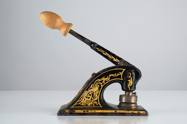
Ceremonial object - Common Seal
Bridgewater is a situated 39km northwest of Bendigo and 170 km from Melbourne. It was established as a crossing point over the Loddon River for gold diggers en route to the Inglewood gold diggings. As gold began to dry up in the district the town of Bridgewater developed due to its proximity to the river which it relied on for industries such as brewing, farming and market gardens. As demand on the water supply grew, the Water Works were established to ensure supply and manage the quality of the water for drinking. Decorated hand operated cast iron embosser with 40mm seal head attached. Gold and orange painted decorations extend from top edge of handle to sides of base. Original knob has been replace with a newer wooden knob. Well used showing all over signs of wear. Seal is for the Bridgewater Waterworks Trust 1927.Bridgewater Waterworks Trust 1927.loddon shire -
 Bendigo Historical Society Inc.
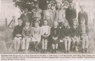
Newspaper - JENNY FOLEY COLLECTION: SCHOOL'S IN
BHS CollectionBendigo Advertiser ''The way we were'' from 2003. School's in: Woodstock on Loddon state school no. 3492, in 1949. Back left to right: Merryn Bell, John Barry, Ellen Cooper, Reg Stone, George Hamilton. Front: Keith Burrows, Ron Bell, Margaret Bell, Lorna Hamilton, Grace Hamilton, Patricia Magee, Barbara Wishart, Graham Stone. The clip is in a folder.newspaper, bendigo advertiser, the way we were -
 Uniting Church Archives - Synod of Victoria
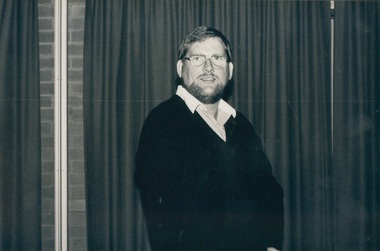
Photograph, Rev Paul C Blacker, 1987-1988
Paul Blacker left school at 15 to start a printing apprenticeship, he then entered Otira obtained his HSC & Local Preachers Certificate was a lay preacher at Moonee Ponds in 1977, Ordained 1988, First ministry was Daylesford from 01/88 to 08/91, Eaglehawk 09/91 to 09/97, Presbytery Minister for the Loddon-Campaspe Presbytery, Synod of Victoria & Tasmania placement; Minister of Hoppers Crossing UC; Minister of Melton UC. Chairperson of Port Phillip West Presbytery.B & W waist length photograph of Rev. Paul C. Blacker wearing a dark jumper and glasses.rev paul c blacker, port phillip presbytery, loddon-campaspe presbytery -
 Ballarat Heritage Services
Photograph - Photograph - Colour, Clare Gervasoni, Carisbrook Police Lockup, c1998, c1998
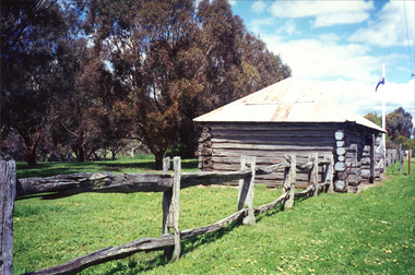
The Carisbrook Police Lockup, originally known as the Loddon Punt, was opened in 1851. At that time it was part of the Castlemaine Police District. Standing in the park beside Bucknall Street it is the town's one significant historic building. It was originally built on the police paddock adjacent to the primary school and moved to its present site in 1886. The walls are made of interlocking horizontally-laid logs. The shingle roof has been replaced with corrugated iron. The lockup was registered by the National Trust on 22/10/1964.Colour photograph of a log building known as the Carisbrook Police Lockup.carisbrook, carisbrook lockup, carisbrook police lockup, log cabin, police, police paddock -
 City of Greater Bendigo - Civic Collection
Administrative record - Land Sales, Department of Lands and Survey et al, 1929
This type of album was created by agents auctioning and selling land.Large portfolio style album with green cloth cover bound with three large metal pins. One hundred and then pages with thirty three Department of Lands and Survey maps pasted in. Index page. Maps have handwritten notes and markings throughout in pencil and pen. Covers the Counties of Bendigo, Rodney, Talbot, Gunbower, Gladstone, Tatchera and Karkarooc, Shires of East Loddon and Huntly and Swan Hill District. -
 Bendigo Historical Society Inc.
Newspaper - JENNY FOLEY COLLECTION: WINNERS
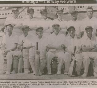
BHS CollectionBendigo Advertiser ''The way we were'' from 2003. Winners: the Upper Loddon Country Cricket week team, circa 1957. Back row from left: H. Tibbet,. Scullie, J. Bisset, J. Jennings, F. Collins, B. Pipcorn. Front row from left: A. Collins, J. Graham, K. Graham, H. Collins, L. Ramm, G. Cocks. The clip is in a folder.newspaper, bendigo advertiser, the way we were -
 Bendigo Historical Society Inc.
Photograph - HARRY BIGGS COLLECTION: PHOTO OF ABORIGINAL CAMP
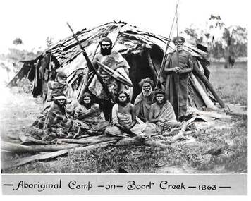
Black and white photo of a group of Jajoweroung or Loddon Aboriginal people in front of their camp. The group consists of four women sitting behind some wooden branches and four men all in native dress. Two men are standing holding spears and two are sitting. The male standing to the left is Prince Charlie and standing to the right is Batten. Behind them is a hut made of bark and sticks. On the bottom of the photo is printed in black ink 'Aboriginal Camp - on - Boort Creek - 1863 -' Photo is inside envelope 2400 418a. On the back of photo 2400 419a the following is hand written in blue ink. The Jajoweroung or Loddon Tribe of Blacks. Aboriginal Camp - on Boort Creek, 1863. Names of Aborigines - Left to Right. Women sitting in front row - Lizzie, Caroline, Maryanne, Kitty. The two men sitting behind the women - Adam, Nero. The two men standing back row - Prince Charlie, Batten. Photo is in envelope 2400.418aphoto, group, aboriginal camp boort creek, boort creek, prince charles, jajoweroung or loddon tribe -
 Federation University Historical Collection
Book, Stanley B. Hunter, Memoirs of the Geological Survey of Victoria No 7., The Deep Leads of Victoria, 1909
Pink paper covered book by Stanley Hunter, Engineer in Charge of Boring Operations. Contents include tunnelling, deep sinking, the Chiltern Method, the Ballarat Method, Stawell, Ararat, Moyston, Raglan, Wimmera, Landsborough, Avoca, Ballarat West Leads, Berry-Moolort-Loddon Lead System, Clunes, Creswick, Bullarook Affluent, Corinella, Daylesford-Castlemaine Tributary, Majorca-Carisbrook tributary, Huntly, Coliban, Campaspe, Rutherglen., Smythesdale, Durham Lead, Tanjil, Evolution of Mining Machinery, size of claims, Definition of a Deep Lead, Discovery of Gold in Victoria, Geographical Position of Deep Leads, Water in Deep Leads, Methods of Deep Lead Mining, Cost of Deep Lead Mining, Stawell, Ararat, Moyston, Raglan, Wimmera, Landsborough, Avoca, Ballarat West, Berry, Springs Hill, Loddon Valley, Charlotte Plains, , Timor, Burn Creek, Huntly, Colinan, Goulburn, Ovens Valley, Chiltern, Indigo, Morrison's Lead, Plans include: geological Map of Stawell, ararat, Raglan and Landsborough; Kempson's Freehold Mine, Stawell; Geological Map of Beaufort, Avoca, Maryborough, Ballarat west, Berry-Moolort, Loddon, Creswick, Marong, &c; Cardigan Propriety Gold Mine; Working Miners United Gold Mine, Homebush; Hepburn Deep Lead Plan; Madame Berry West Mine; West Berry Consols Mine; Spring Hill and Central Leads; Berry Consols Extended Mine; Loddon Valley Goldfields; Chalk's No 3 Mine; Charlotte Plains Considated Mine; Duke United Mine; Geological Map of Bendigo, Huntley, Campaspe, Malmsbury, Kyneton, trentham, &c; Geological Map of Chiltern, Rutherglan, Eldorado, Beechworth, &c; Chiltern Valley Gold Mine; Wallace Chiltern Valley Consols Mine; great Southern and Chiltern Valley United Mine; great Northern extended Consols; Prentice and Southern deep Leads; Glenfine South Gold Mine; Geological map of Pitfield, Rokewood, Mt Mercer, Ballark, Meredith, &c.; McEvoy Mine; Dargo . . . . . . . . . . . . . . . . . . . . . . . mining, deep leads, squire, tools, gold panning, gold cradle, cradling, puddling, tubbing, mining shaft, shaft sinking, whip, horse whip, whim, horse whim, chalk's no. 1 mine, maryborough, mining cage, shaft, mining trucks, maryborough, washdirt, puddler, tunnelling, deep sinking, chiltern method of working, ballarat method of working, sampling washdirt. gravels, balmoral, mt william, stawell, moyston, great western, ararat, raglan, wimmera valley, landsborough, cardigan, haddon, beaufort, waterloo, avoca, lamplough, caralulup, ballarat west, ballarat, smythesdale, glenfine, illabarook, durham lead, morrison's lead, bullengarook, berry-moolort-loddon system, clunes, creswick, spring hill, bullarook, castlemaine - daylesford, majorca, carisbrook, timor, burnt creek tributary, tarnagulla, marong, rheola, inglewood, huntly, coliban, campaspe, goulburn lead system, ovens valley system, mitta mitta, kiewa valley, tarago, tanjil, moondarra, bogong, dargo high plains -
 Bendigo Military Museum
Certificate - CERTIFICATE, FRAMED WW2, Arnall & Jackson, c.1940's
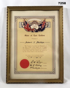
Certificate "FOR KING/ AND/ COUNTRY" from 'SHIRE OF EAST LODDON" "CERTIFICATE IN APPRECIATION FOR SERVICES RENDERED IN THE GREAT WORLD WAR 1939-45" "Robert T. Phillips" Robert Thomas Phillips V28869 (AMF) VX113093 (2nd AIF). Enlisted 16.12.1941 age 20 years 7 months as V28869, transferred to the AIF 14.10.1942 in 2/2nd Tank Transporter Coy ASC, listed as served in Adelaide River, Winnellie and Darwin between 25.11.1943 to 23.9.1945. Discharged 19/10/45 with the rank CPL in A.A. Pay Corps.CERTIFICATE - ORIGINAL, ON PAPER. Dark Brown print. Illustrated in colours, red, blue, yellow and beige. Top - Rising Sun Badge with British and Australian Flags, outline map of Australia and surrounded by decorative scroll work. Bottom - Red seal. Certificate framed with decorative line and scroll work. Frame - timber, gold colour paint with black paint highlights to decorate moulding. Glass front. Backing - cardboard and brown paper. Original metal hanging clips and cotton cord.Handwritten in black ink: "Robert T. Phillips" - 6th April 1946, Signed by R.W. Bogie, President. H.C....???...... Councilor, A. Gutherie Shire Secretary.framed accessories, certificate, ww2, shire of east loddon -
 Bendigo Military Museum
Certificate - CERTIFICATE, FRAMED, Framed certificate presented to Robert Badon
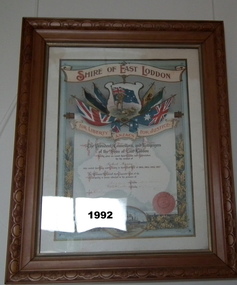
Item in the collection re Robert H Baron No 3596, refer Cat No 1981P for his service history. Framed Coloured Certificate from the " Shire of East Loddon/ For Liberty Anzacs Justice" to Robert Baron, dated November 13, 1917. Certificate - red print and handwritten detail in red ink. Illustrated background in colour - flags, flora and ship; and silhouette of Australia. Frame - timber, light brown stain, decorative edge with gold painted inner edge, glass front. Mount - white cardboard with gold coloured inner mount.Handwritten in red ink on certificate "Robert Baron" - remainder of writing illegible.certificate, history, ww1, cooper collection -
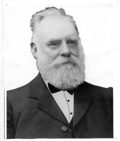 Tarnagulla History Archive
Photograph of John Shields Simpson, circa 1880s
Murray Comrie Collection. Information written by Murray Comrie: John Shields Simpson was born in Scotland in 1831, came to Victoria in 1853 and after mining for a time took up land at what was later to be the Nick O'Time Lead at Poseidon. He took up a store at Newbridge and in 1905 built a hotel alongside the store. Both were severely damaged in floods of the Loddon River in 1909. He was elected to the Tarnagulla Borough Council in 1882 and retained his seat until 1915 when he resigned. He was Mayor of the Borough on five occasions. Monochrome photographic portrait of a bearded man.Accompanying note identifies subject as John Shields Simpson.borough of tarnagulla, john shields simpson, mayor, council, local government, local people, newbridge, store, hotel