Showing 3911 items
matching macedon
-
 Malmsbury Historical Society
Photograph (Item), B/W Alf Bates & Mrs Crowe Outside Bakery, Malmsbury 9/4/1991
People - "Manktelow, D; Bates, A; Crowe, Mrs" Buildings - "Malmsbury Bakery,Mollinson St." Associated with - M.H.S.Leader Newspaper (Macedon Ranges) H/Week -
 Hume City Civic Collection
Photograph, Late 1990's
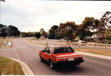
Riddell Road is the continuation of Macedon Street and is on the west side of the town centre. It is the main road to Riddells Creek, the Sunbury airstrip, Sunbury tip and water towers.A coloured photograph of Riddell Road looking west. A red car is in the foreground travelling north and is at the T intersection of Riddell Road and Ligar Street. There are houses along the north side of Riddell Road and the football ground is on the south side of the road.sunbury football club, riddell road, ligar street, george evans collection -
Malmsbury Historical Society
Photograph (Item), "B/W N. Monti, J. Hannigan", Malmsbury ca1991
People - "Monti, Norm; Hannigan, J; Manktelow, Denis" Buildings - Mollinson St.Hotel/Post Office Associated with - M.H.S.Leader Newspaper (Macedon Ranges) H/Week -
 Sunbury Family History and Heritage Society Inc.
Photograph, Rosa McCall, Former Sunbury Library, December 2017
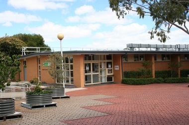
The building in the photograph is the former Sunbury Library in Macedon Street, which closed in December 2017 to make way for the construction of a larger library, which was to be built on the site.A digital coloured photo of a wide, paved area with trees growing in metal containers in front of the main entrance to a flat-roofed cream-brick building. libraries, sunbury library, macedon street -
 Hume City Civic Collection
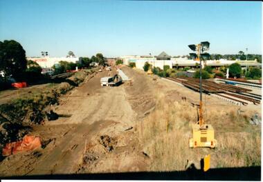
Photograph, 21/04/2005
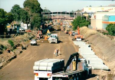
This photograph was taken during the upgrade of the Bendigo Railway line at Sunbury Station. The upgrade took twelve months to complete and during that time bus services replaced the trains.A coloured photograph of construction on the site of the Sunbury Railway Station. The photograph has been taken from the Macedon Street bridge looking south towards the station and the pedestrian bridge over the railway tracks. On the tracks the old railway lines have been removed and storm water pipes are being put into position before the new lines are to be laid.railways, bendigo line, railway stations, bridges, sunbury railway station, george evans collection -
University of Melbourne, Burnley Campus Archives
Nursery catalogues, Nursery Catalogues: booklets & foolscap sheets
nurseries, plant nomenclaturenurseries, plant nomenclature -
 Creswick Campus Historical Collection - University of Melbourne
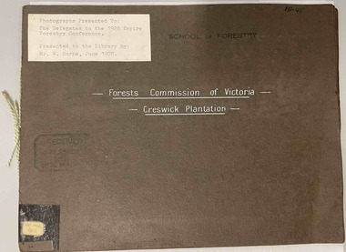
Photograph - Forests Commission of Victoria - Creswick Plantation, 3 booklets of Photographs presented to the delegates to the 1928 Empire Forestry Conference, 1928
This is a folio of photographs of the Creswick Plantations presented to the 1928 Empire Forestry Conference. related to item 1434. 2 additional folios -State Nursery Macedon. Ballarat Botanic Gardens. Photographs of mature specimens of timber trees from the State plantation Creswick, the State Nursery Macedon and the Ballarat Botanic Gardens. Photographs loosely bound into 3 sets. 2 x dark brown loose covers, 1 x dark green loose cover, bound with coloured embroidery thread.PhotographsPresented to the delegates to the 1928 Empire Forestry conference by the Forests Commission of Victoria -
 Sunbury Family History and Heritage Society Inc.
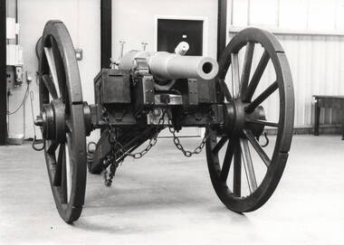
Photograph, Sunbury Gun
The Sunbury Gun was originally donated to the Shire of Bulla by the Clarke family. For many years it stood at the intersection of Barkly, Stawell and Macedon Streets. Over the years it became very dilapidated and as traffic along Macedon Street gradually increased it was decided to refresh and relocate it to a triangular site opposite the Memorial Hall in 1970. In March 1982, the weathered Sunbury Gun was restored and housed in an atmospherically controlled glass case and displayed again in the triangular site opposite the Memorial Hall along with the War Memorial and the Starkie fountain.A non-digital black and white photograph of a gun in a large building.sunbury gun, memorial hall, clarke family, stawell street, barkly street -
 Sunbury Family History and Heritage Society Inc.
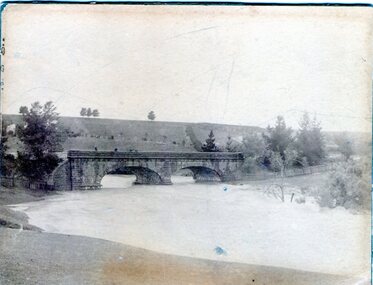
Photograph, 1916 - 1917
The Jacksons Creek is prone to flooding when rainfall is very heavy. The flood pictured in the photograph occurred either in 1916 or 1917 and reached at a level close to the arches on the Macedon Street bridge.A sepia photograph backed on cardboard of a two arched bridge with a river in flood.floods, jacksons creek, macedon street bridge -
 Hume City Civic Collection
Photograph, 21/04/2005
This photograph was taken during the upgrade of the Bendigo Railway line at Sunbury Station. The upgrade of the line took over twelve months to complete and bus services replaced the train service during that time.A coloured photograph of construction on the site of the Sunbury Railway Station. The photograph has been taken from the Macedon Street bridge and is looking south towards Station Street. The old rail tracks have been removed and excavation work is in progress to make way for the new tracks. The new rail lines have been placed on the side of the track on the RHS of the photograph.railways, bendigo line, railway stations, bridges, sunbury railway station, george evans collection -
 Sunbury Family History and Heritage Society Inc.
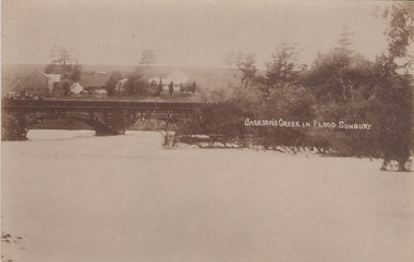
Photograph
The post card is a record of a time when the Jacksons Creek flooded and the water almost reached the two arches on the Macedon Street Bridge. The Goonawarra Winery buildings can be seen in the back ground.A sepia photograph in post card format of a river in flood with the water almost reaching the two arches on the stone bridge. Farm buildings can be seen in the middle distance.JACKSON'S CREEK IN FLOOD SUNBURYmacedon street bridge, jacksons creek, goonawarra winery -
Glen Eira Historical Society
Letter - Christian Family
Handwritten letter dated 17/07/1976 to Caulfield Historical Society from Keith Chappel, advising them that Thomas Christian of Mount Macedon is in no way related to Thomas Christian of Myoora, Caulfield.christian thomas, myoora, caulfield, chappel keith, house names -
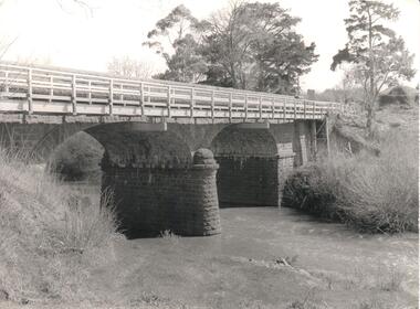 Hume City Civic Collection
Photograph, Early 1970s
The Macedon Street Bridge over Jacksons Creek is important because it was built on one of Victoria's first important roads. It replaced a smaller lighter bridge in 1857 and continued to be used until the early 1970s.A black and white photograph of a two arched bluestone bridge over a creek. A wooden post and rail fence painted white has been constructed in front of the original stone wall of the bridge.bridges, bluestone bridges, jacksons creek, macedon street, george evans collection -
 Sunbury Family History and Heritage Society Inc.
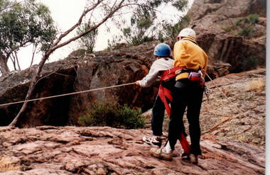
Photograph, Bulla Primary School, Hanging Rock, 18th October 1995
The older students were attending a school camp at Hanging Rock in the Macedon Ranges area in 1995 and one of the activities the children were introduced to was rock climbing as the formation offers many sites for this activity.A non-digital coloured photograph of a supervisor instructing a girl who is attempting to do rock climbing. They are doing the activity on a natural rocky plateau.school camps, hanging rock, rock climbing, bulla primary school -
 Orbost & District Historical Society
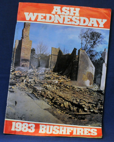
newsaper/magazine, Ash Wednesday, February 1983
This magazine was published to raise money for the State Disaster appeal. It was a tribute to the photographers and reporters who contributed to the coverage of the Ash Wednesday bushfires for these publications.this item is a contemporary record of a major fire disaster in Victoria and is a useful reference tool.A large 78 pp stapled magazine. On the front cover is a coloured photograph of the town of Macedon the morning after the bush fires in February 1983. It has white ASH WEDNESDAY in print on a red background above the photograph and 1983 BUSHFIRES in white print on a red background belop the photograph. The photograph extends to the back cover. The magazine contains black/white photographs, stories and reports.bushfires ash-wednesday magazine disasters-victoria -
 Bendigo Historical Society Inc.
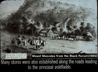
Slide - DIGGERS & MINING. STORES AT THE DIGGINGS, c1855
Diggers & Mining. Stores at the diggings. STG From the original in the Mitchell Library. Mount Macedon from the Black Forest. (1855) Many stores were also established along the roads leading to the principal goldfields. Slide depicts at group of Chinese passing by a store in the Black Forest o the way to the diggings. Markings: 35 994.LIF. 5. Used as a teaching aid.hanimounteducation, tertiary, goldfields -
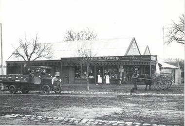 Sunbury Family History and Heritage Society Inc.
Photograph, Commercial Stores
Commercial Stores was owned and run by Peter Eadie from Perthshire in Scotland, whose brothers were John and Robert. Peter and Robert arrived in Sunbury in 1864 to help their brother John with his milling enterprise. In 1866, Peter purchased the blue stone general store in Macedon Street near the bridge. He later built the Commercial Hotel also in Macedon Street and near the Ballcourt Hotel.Before the railway arrived in Sunbury, Macedon Street was Sunbury's main commercial centre. After the establishment of the railway, the commercial centre shifted close to the railway station. The Eadie family's stately home, 'Dunblane', was on the corner of Brook and Jackson Street.A Lutheran Church now occupies the lower section of the land fronting Brook Street, but the home has a local heritage listing. Peter Eadie became a Shire of Bulla councillor and President in 1880. Dunblane is from the Scots Gaelic -'dun' is a fortified hill and 'Blane' a missionary.The Eadie Family established one of Sunbury's general stores in the town and were involved in many other commercial activities.A print of a non-digital black and white photograph of a country general store. A medium sized vintage open tray truck is parked in front of the shop on the LHSand a horse-drawn open cart is on the RHS of the image.eadie family, peter eadie, commercial stores, macedon street, businesses -
 Hume City Civic Collection
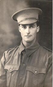
Photograph
From the information on the back, the soldier in the photograph has been identified as Dr. Falkiner's son. Dr. Falkiner was a doctor who practised medicine in Sunbury. He built "Ardcloney" mansion in Macedon Street, Sunbury.A black and white photograph of a soldier from the waist up identified only as Doc Falkiner's son. Unmounted.written on back: Doc Falkiner's sonsoldiers, armed forces, uniforms, portraits, falkiner, - (dr), talma, photographers, clothing and dress, george evans collection -
 Hume City Civic Collection
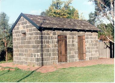
Photograph
The Aitken Gap Gaol was originally constructed at the Gap Settlement on the Calder Highway in 1857 for the gold escorts. It was relocated to its present site outside the Sunbury Police Station in Macedon Street between 1989 and 1991.A coloured photograph of the relocated Aitken Gap Gaol. It has bluestone walls and a moss covered slate roof. with 2 solid stained wooden doors and blue painted wooden trims. A small cell window is on the side of the building and a paved brick area surrounds the gaol.aitken gap gaol, gap village, sunbury police station, george evans collection -
 Sunbury Family History and Heritage Society Inc.
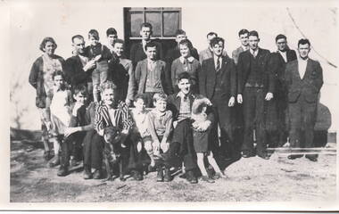
Photograph, c1940s
The people in the photograph are outside the Sir John Franklin Hotel which was one of the first hotels to be established in Sunbury in the early days of European settlement along Macedon Street. It continued to operate into the first half of the twentieth century.A non-digital black and white photograph with a cream border. of twenty two people and a dog standing and sitting outside a hotel building.sir john franklin hotel, hotels, sunbury -
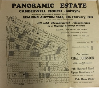 Kew Historical Society Inc
Plan - Subdivision Plan, Panoramic Estate, Camberwell North (Balwyn), 1939, 1939
Subdivision plan advertised as the Panoramic Estate, Balwyn, showing lots for sale in the following streets: Bulleen Road, Macedon Avenue, The Moor, Sunburst Avenue, Doncaster Road, Fortuna Avenue, Longview Road, The Nook, and Touring Avenue.Single page subdivision plan of the Panoramic Estate in Camberwell North (Balwyn); offered for sale in 1939Nilsubdivision plans - balwyn (vic), panoramic estate - camberwell north - balwyn (vic) -
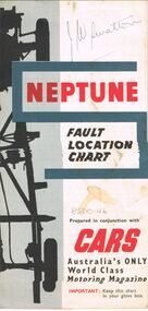 Bendigo Historical Society Inc.
Map - J W SWATTON COLLECTION: MAPS
Seven maps of various sizes. Map of the City of Ballarat, Victoria, Road Condition Map of Victoria including Melbourne-Cairns & Melbourne-Adelaide, Neptune Fault Location Chart, Grampians District Map, Racv Tour Planning Map Showing Road Conditions for Victoria, NSW and Queensland and Mt Macedon & District. Two of the maps have J W swatton & J Swatton written on them.j w swatton collection, racv, mobil, neptune, a r blair, j ewins & sons pty ltd, berry anderson & co -
Bendigo Historical Society Inc.
Document - Map outlining Australia's natural hazard zones
John Perry collection. Laminated document. Color. Map of Australia in the middle of document surrounded by 10 images of natural disasters that have occurred in Australia in Cairns, Darwin, Cleve, Northam, Central Queensland, Mt. Macedon, Dandenong Ranges, Benalla, Healesville, and Charleville. Legend demonstrates different types of natural disasters and zones in which they are more likely to occur. Has logo of Australian Red Cross at the bottom of document. map, tornado, cyclone, flood, drought, natural disasters -
 Hume City Civic Collection
Photograph - Evans Street, Sunbury, c1880 - 1900s
The photograph shows a picture of Evans Street Sunbury taken from the T intersection at Macedon Street and looking south. When the photograph was taken it was one of Sunbury's main residential areas. Since the 1980s the houses in the image have been demolished and replaced with commercial development.- Over the years Evans Street has undergone much change from being a residential strip to being the main commercial hub in Sunbury.– An enlarged photograph of a streetscape with a row of trees growing along the footpath and a number of weatherboard Victorian style double fronted cottages. Both the roadway and footpath are not surfaced and the gutter is lined with stone pavers.sunbury -
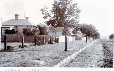 Sunbury Family History and Heritage Society Inc.
Photograph - Evans Street, Sunbury, c1900s
The photograph shows a picture of Evans Street Sunbury taken from the T intersection at Macedon Street and looking south. When the photograph was taken it was one of Sunbury's main residential areas. Since the 1980s the houses in the image have been demolished and replaced with commercial development. Over the years Evans Street has undergone much change from being a residential strip to being the main commercial hub in Sunbury.A sepia photograph with a white border across the bottom and in post card format of a streetscape with a row of trees growing along the footpath and a number of weatherboard Victorian style double fronted cottages. Both the roadway and footpath are not surfaced and the gutter is lined with stone pavers.EVANS STREETevans street -
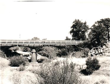 Hume City Civic Collection
Photograph, 1960s
The two-arched bluestone bridge which spans the Jacksons Creek at the east end of Sunbury township, was built in 1857 and continued to be used as a road bridge on the main Sunbury Road-Macedon Street until the early 1970s when a wider bridge replaced the original bluestone bridge.A black and white photograph of a two- arched bluestone bridge which spans a dry creek bed. A bulldozer is on the riverbank on the RHS of the photograph.bridges, bluestone bridges, jacksons creek, harris, thomas lascelles, macedon street, george evans collection -
 Sunbury Family History and Heritage Society Inc.
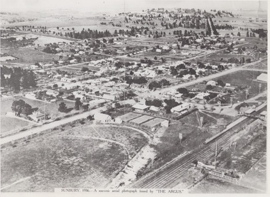
Photograph, 1936
The aerial view of Sunbury was featured in The Argus newspaper in 1936 in recognition of 100 years of European settlement of the area. It shows the extent of the township in 1936 which extended from the railway line in the west to the Jackson Creek in the east and the Sunbury Asylum in the south and northwards towards Macedon Street. The photograph was taken when Sunbury was a country settlement 25 miles ( 37 kms) from Melbourne. Since the 1980s the area grown rapidly and is now an outer suburb of Melbourne.A black and white aerial photograph with a cream border of the Sunbury township. SUNBURY 1936 - A SOUVENIR AERIAL PHOTOGRAPH ISSUED BY THE ARGUS.aerial photographs -
 Sunbury Family History and Heritage Society Inc.
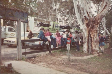
Photograph, Bulla Primary School, 1984
Portable classrooms being brought into a school was how many schools accommodated children when there was an increase in student enrolments and there were insufficient classrooms available at a school. This portable room was transported from Macedon Primary School in September 1984 and it became known as Room 1 at Bulla. The use of portable classrooms was widespread across Victoria especially from 1945 to the end of last century.A non-digital coloured photograph with school children sitting and standing on a fence watching a portable classroom being transported to their school. bulla primary school, bulla, schools, portable classrooms -
 Hume City Civic Collection
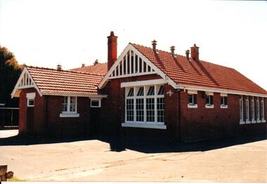
Photograph, early 1990s
The brick building was constructed in 1911/1912 and replaced an earlier school building. In 1942/43 the school building was extended to cope with the increased population in Sunbury. The State School remained on the Macedon Street site until 1999 when it was relocated to the restored former Industrial School at Jacksons Hill.A coloured photograph of the former Sunbury State School No. 1002. It is a red brick Federation building with a red terracotta tiled roof and wooden white painted trims. There are two stepped brick chimneys with terracotta chimney pots and six air vents protruding from the roof. There is a small porch at the front of the building.carirns, j. f. dr., eadie, peter, education department, george evans collection -
 Hume City Civic Collection
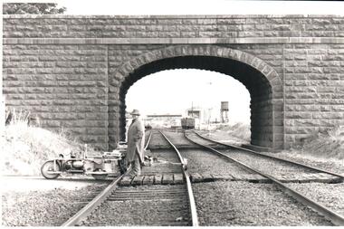
Photograph, Pre 1989
The bluestone 'road over rail' bridge at Macedon Street is of state architectural, architectural, historical and engineering significance. It spans the first government regional railway. Its design and building was done according to strict English standards and made use of a bridge crossing instead of a level road crossing.A black and white photograph of a stone bridge with an eliptical arch spanning two rail tracks. A workman is standing between one set of tracks in the foreground and a railcart is next to the tracks. The station, footbridge and water tower are visible through the arch.road over rail bridge, bridges, sunbury railway station, water towers, pedestrian bridges, stone bridges, george evans collection