Showing 11646 items matching "merri"
-
 Melbourne Tram Museum
Slide - Set of 17 - Tramway Shelters, Robert Green, c1990
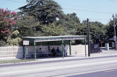
Set of 17 colour slides of tramway shelters, poles, and substations by Robert Green c1990. Shelters by the PMTT, HTT and MMTB 1 Tramway Shelter (PMTT) - Cnr Balaclava and Orrong Road, Caulfield 2 - ditto 3 - Tramway Shelter (PMTT) - Cnr. Cotham Road and Burke Road, Deepdene 4 - Tramway Shelter (PMTT) - Cnr. Cotham Road and Burke Road, Deepdene with telephone box alongside. 5 - Cnr. Malvern Rd and Orrong Road, Toorak 6 - Cnr. Malvern Rd and Orrong Road, Toorak 7 - Cnr. Dandenong Road and Hawthorn Road, Caufield 8 - ditto 9 - PMTT Substation - Rusden Street, Elsternwick 10 - PMTT poles cnr. Dandenong Road and Wattletree Road 11 - Tram shelter (HTT) Riversdale Road and Highfield Road - Camberwell - Highfield Park 12 - Tram shelter (HTT) Riversdale Road and Wattlevalley Road, Camberwell 13 - ditto 14 - Tram shelter (HTT) Camberwell Road, cnr Bowen St. Camberwell. 15 - Tram Shelter (HTT) Camberwell Depot, Riversdale Road, Hawthorn 16 - Merri Creek Bridge, St. Georges Road, North Fitzroy 17 - Merri Creek Bridge, St. Georges Road, North Fitzroy - foundation stone Yields information about Melbourne's tramway stop shelters and other infrastructure.Set of 17 Kodak colour slides in plastic mounts.tramways, shelters, caufield, deepdene, toorak, orrong road, cotham road, balaclava road, pmtt, htt, mmtb, riversdale road, camberwell depot, merri creek bridge, foundation stone, dandenong road, poles, rusden st, substations, hawthorn road, st.georges road -
 Bendigo Military Museum
Postcard - PHOTOGRAPHIC POSTCARDS WW1, C.WW1
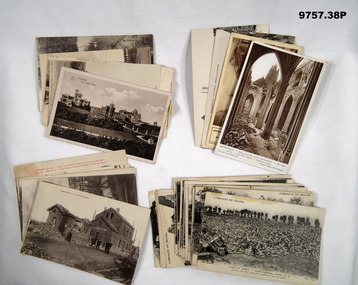
Items in the collection relating to C.J.C. McQuie MM, refer Cat No 9680P for his service details. Postcard No's .10) - 15). These are from a Series that have printed text in Red at the top of the images. Postcards .16) - 38). These are from a major Series, all have at the top "Campagne DE 1914 - 1916" and cover bomb damage in many areas across the "Somme" region..1) Postcard sepia tone of a Chalet in "Ostende". .2) Postcard sepia tone of a Church 1916 "Strazeele". .3) Postcard sepia tone, river scene in "Amiens". .4) - .5) One sepia, one B & W scenes in "Hazebrouck". .6) Postcard B & W, bomb damage "Albert". .7) Postcard B & W, bomb damage "Hazebrouck". .8) - .9) Postcard One B & W one sepia Bomb damage "Dunkerque" .10) - .11) Postcard B & W bomb damage around "Strazeele". .12) Postcard sepia tone, bomb damage "Strazeele". .13) Postcard B & W, bomb damage "Kemmel". .14) Postcard B & W, bomb damage "Merris". .15) Postcard B & W, bomb damage "Messines". .16) - .38) B & W series bomb damage various places. postcards, photos, mcquie -
 Flagstaff Hill Maritime Museum and Village
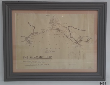
Document - Location Chart, The Mahogany Ship, 2007
This chart shows a possible site for the fabled wreck called the 'Mahogany Ship'. Flagstaff Hill’s collection includes other objects that some say could be relics from this Ancient Wreck, (also called the Gold Ship, or the Ancient Vessel). The chart shows the coordinates for the Summits of Griffith Island and of Middle Island. It also has the depths of the sea at various intervals and shows the shore and sand dunes, lighthouses and other reference points. The mystery of the Mahogany Ship began in 1836 when two shipwrecked sealers discovered the remains of an “ancient vessel” in the sand dunes about four miles west of Warrnambool. Since the last recorded sightings in the 1880’s the true origin of the Mahogany Ship has remained one of Australia’s most famous historical mysteries or fables. One of the more recent theories is that the vessel was one of the Portuguese ships exploring the Australian coast in 1522. For over one hundred years searchers have attempted to locate and identify the wreck. The search continues for the tangible evidence which will once and for all establish the Mahogany Ship’s place in Australia’s History.The chart represents the worldwide interest in locating the wreck of the Mahogany Ship. Locating the actual wreck or proving the existence of a Portuguese ship's wreck could change the history of the discovery of Australia. A Mahogany Ship committee was formed to gather and research information about the discovery of the wrecked ship. A large amount of money was offered as a prize for finding the wreck or parts of it. People have written books, painted images, made videos and told tales of the ship but it continues to remain a mystery or even a fable. The chart is significant for its possible link to one of Victoria’s and Australia’s maritime mysteries, the Mahogany Ship (also known as the Ancient Wreck). It is one of very few known relics that could give evidence of the existence and history of the vessel. It is listed on the Victorian Heritage Register S438 as it is one of Victoria’s oldest recorded shipwrecks. The identity of the vessel has the potential to change Australia’s history.A chart in a wooden frame, behind glass. The chart shows the approximate position of the mystery Ancient Wreck, later called the "Mahogany Ship". The chart is a copy and is based on the Admiralty Chart by Lieut. Stanley, dated 1872. Lower left: "THE MAHOGANY SHIP" "LOCALITY PLAN, ENLARGED FROM LIEUT. STANLEY'S ADMIRALTY CHART 1872" "APPROXIMATE POSITION OF WRECK MARKED [symbol of a Portuguese cross]" Other labels on chart: "BELFAST" "PORT FIARY" "GRIFFITHS I" "RIVER MOYNE" "RIVER MERRI" "ARMSTRONG BAY" " GORMANS LANE" "TOWER HILL" "KOROIT" "HELEN ROCK" "WARRNAMBOOL" "LADY BAY" "MIDDLE I" "LIGHT HO." Lower right: "G 410 B" Label on the back; "This chart presented to the Mahogany Ship Committee and Flagstaff Hill by Avis Quarrell, April 2007"warrnambool, shipwrecked coast, flagstaff hill maritime museum, shipwreck coast, mahogany ship, ancient vessel, ancient wreck, portuguese ship, coastal reserve, fabled wreck, gold ship, griffiths island, belfast (now port fairy), koroit, location plan, leuit. stanley, admiralty chart 1872, tower hill, merri river, moyne river, middle island, helen rock, armstrong bay, griffiths land -
 Warrnambool and District Historical Society Inc.
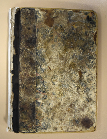
Administrative record - Warrnambool Waterworks Newspaper Cuttings, 1891 to 1917
This ledger contains newspaper cuttings form The Warrnambool Standard newspaper from May 1891 to October 1917. The cuttings are reports of meetings of the Warrnambool Waterworks Trust. In the early days of Warrnambool domestic water and water for fire suppression was supplied by tanks, wells and springs. In the 1870s various schemes were proposed to find a better supply of water. In 1891 the Warrnambool Waterworks Trust was formed using water from the Merri River. This system lasted until 1939 when the Warrnambool water supply came from the Otway ranges. This system is still the water supply for Warrnambool today. The cuttings in this ledger will be useful for research.This is a ledger with a brown mottled cover and a leather spine and leather corners. The spine is partly detached. The front cover has a label pasted on it. The pages originally had hand written entries (The Minutes of a Warrnambool organisation). Newspaper cuttings have been pasted over the original writing. Warrnambool Waterworks Trust Newspaper Reports From 19th May 1891 To --- warrnambool waterworks trust, warrnambool water supply -
 Warrnambool and District Historical Society Inc.
Document - Documents (3) of Farnham Cheese and Butter factory, 1890s (originals)
These three sheets are copies of the originals and relate to the establishment of the Farnham Cheese and Butter Factory in Dennington (Warrnambool). The name 'Farnham' is the name of the Special Survey in the area first purchased by William Rutledge and also the name of the Rutledge property at Dennington. In 1889 WIlliam Rutledge (Junior) and Thomas Palmer established the Farnham Cheese and Butter Factory on the banks of the Merri River at Dennington. In 1890 they sold the factory to a farmers' co-operative. Farnham had a high reputationfor butter=making when the factory was in existence. The factory was bought out by Nestles about 1909 with that company establishing its factory on the same area.in 1911. These documents are of interest as the Farnham Cheese and Butter Factory was one of the earliest of its type in the Western District and won a Gold Medal in 1909 for butter-making at the Islington Dairy Show in competition with other butter-making countries in the world..1 sheet of paper with black and white map showing location of factory in Dennington (copy) .2 An A3 size piece of paper with a sketch map and typed material showing a Certificate of Title (copy) .3 An 3 size piece of paper with a sketch map and typed material showing a Certificate of Title (copy)farnham cheese and butter factory, nestles factory warrnambool -
 Melbourne Tram Museum
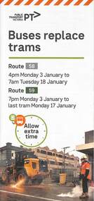
Pamphlet, Yarra Trams, Buses Replace Trams - Routes 58, 59, 86 and 96, 2022
.1 - pamphlet provided at tram stops giving details of the works and bus services for routes 58 and 59 .2 - Project document describing the work and dates - downloaded from the Yarra Trams website after buses were used to replace route 58 from the Royal Children's Hospital rather than from Royal Park Station as originally planned. .3 - as for .1 - for the upgrading of the Merri Creek Bridge - route 86 - see also Reg Item 6066 .4 - as for .1 - for the installation of superstops in Nicholson St between Elgin St and Holden St - route 96Shows the methods that Yarra Trams customers are advised of changes due to track replacement works..1 - Pamphlet - DL, four fold printed on off white paper titled - Buses Replace Trams - Route 58 and Route 59 - Jan 2022 .2 - Project sheet - 3 A4 sheets, titled "Renewal works: Essendon Depot and Mt Alexander Road - 3.1 to 18.1.2022. .3 - Pamphlet - DL 3 fold, Buses Replace Trams, route 86, November 2021 - Merrit Creek Bridge works .4 - Pamphlet - DL - 4 fold, Buses Replace Trams, route 96, January 2020 - Nicholson St works for tram super stops.mt alexander road, tram works, track work, route 58, route 59, yarra trams, ptv, essendon tram depot, route 86, route 96, nicholson st, merri creek, bridges, carlton, super stops, trams, tramways, northcote -
Warrnambool and District Historical Society Inc.
Document (collection) - Henri Worland Historical Records, Henri Worland Collection, 1930s and 1940s
Henri Worland writings collected by the Warrnambool City CouncilPreservation of important historical recordsThe collection is in folders in a containerWritings on Warrnambool history by Henri Worland - radio talks, lectures, letters and notes, hand written and typed.henri worland, warrnambool historyhenri worland, warrnambool history -
 Flagstaff Hill Maritime Museum and Village
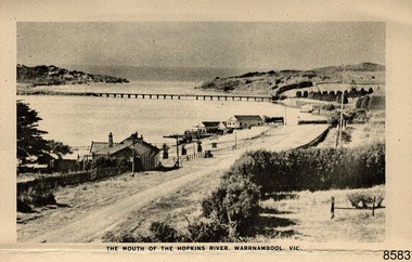
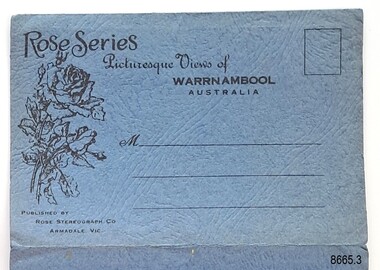
Postcard - Postcard Folder - scenes, George Rose, Rose Stereographic Company, Rose Series Picturesque Views of Warrnambool Australia [Warrnambool], 1880-1942
This postcard folder contains lithographs of photographs taken locally by Georg Rose between 1880 and 1942. He reproduced them at his company's premises, the Rose Stereographic Company at Armadale, Victoria. The postcard folder was purchased as a Warrnambool souvenir by the donor's parents around 1945 to 1950. Interestingly, the city on the cover is printed as "Warrambool", which is a location in New South Wales, but the postcards within all have the locations and text of Warrnambool. The photographs include the 'new' concrete bridge, built in 1922 to replace the original bridge, built in 1872. The boathouses belonging to Proudfoots and to Flett/Fanny Nelson are also pictured on the Hopkins River mouth. The twelve photographs included locations connected to other items in our Collection. The photographs are titled: - b. The Avenue and War Memorial. Warrnambool. Vic. c. The Blow-hole. Thunder Point. Warrnambool. Vic. d. Botanical Gardens. Warrnambool. Vic. e. Eagle Rock. Warrnambool. Vic. f. The New Concrete Bridge and Breakwater. Warrnambool. Vic. g. Liebig Street. Warrnambool. Vic. h. Looking to Thunder Point. Warrnambool. Vic. i. The Beach. Warrnambool. Vic. j. Hopkins Falls. Warrnambool. Vic. k. Shelly Beach. Warrnambool. Vic. l. The Mouth of the Hopkins River. Warrnambool. Vic. m. Panorama of Warrnambool. Vic. [Kepler Street towards Presbyterian Church on Spence St] George Rose, 1861-1942: - famous for his Late 19th and early 20th century photography. He was born in Clunes, Victoria, and was in his 20th year when he founded Rose Stereograph Company in 1880. He took the opportunity of a popular trend of the times to produce stereographs, pairs of almost duplicate photographs which appeared to be in 3D when viewed in a handheld stereo viewer. By the 1920s these lost their popularity, so he used his photographic skills to produce cards and postcards of scenes and people. The photographs in this postcard folder were taken between 1880 and 1942 by the renowned Victorian photographer George Rose. The locations match photographs and postcards in our collection that were taken at different times. A comparison between them shows the changes over time in the land and bay, the buildings and other structures, transportation and even the fashions of the times, building the story of our local history.This copy of a postcard folder has a blue-grey textured rectangular card cover with a sketch of a rose on the front along with the name of the postcard series. the location of the series' focus, the producer's details and lines for adding an address. The folded cover contains a long, concertinaed page with six titled photographs on each side, totalling twelve in all. Interestingly, the cover has the location name of "Warrambool", a place in NSW, instead of Warrnambool, the location of all of the photographs inside. The folder contains scenes from Warrnambool and nearby popular areas including Lady Bay, Port of Warrnambool, Warrnambool Breakwater, Viaduct, Merri River Footbridge, the Hopkins River Mouth, with Proudfoot’s and the Fanny Nelson/Flett boathouses. The cover has a sketch of a rose and inscriptions. The photographs for the lithographs were taken prior between 1880 and 1942 by well-known Victorian photographer, George Rose, Rose Stereograph Company of Armadale, Victoria.Image: [Rose with rosebud and leaves] Printed: "Rose Series / Picturesque Views of / WARRAMBOOL / AUSTRALIA" [correct spelling is WARRNAMBOOL] "PUBLISHED BY / ROSE STEREOGRAPH CO / ARMADALE. VIC." Printed lines (3) for an address. Printed rectangle [ ] for attaching a stamp.flagstaff hill maritime museum and village, great ocean road, shipwreck coast, warrnambool, flagstaff hill, flagstaff hill maritime museum, flagstaff hill maritime village, warramble, postcard, postcard folder, warrnambool scenes, picturesque views of warrnambool, picturesque views of warramble, lady bay, port of warrnambool, breakwater, warrnambool breakwater, viaduct, merri river footbridge, merri river suspension bridge, suspension footbridge, merri river mouth, hopkins river mouth, proudfoot's, fanny nelson, nelson's boatsheds, nelson's boathouse, boathouse, hopkins river boathouses, flett's boathouse, flett, george rose, image of a rose, rose series, rose stereograph co, rose stereographic company, lighograph, armadale victoria, lady bay beach, beach scene, lower light, concrete footbridge, 1922 footbridge, viaduct road, rose postcard, new concrete bridge, 1945, 1890, 1922, small footbridge, 1872 footbridge, 1872, merri river estuary, stingray bay, postcards -
 Warrnambool and District Historical Society Inc.
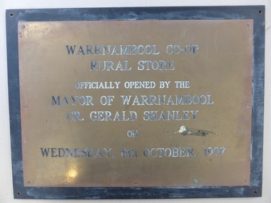
Plaque, Warrnambool Co-op Rural Store, 1997
The Warrnambool Co-operative had its beginnings as the Allansford Artificial Breeders Co-operative in the 1960's. In the 1970s they opened a retail store in Timor Street which had a strong rural and farming base which gradually expanded to become the largest trading department store in the district. By the late 1990's they had 8000 members and employed 84 full time and 120 casual staff. It met a sorry end in the 2000's.This plaque commemorates the opening of the Rural store which consolidated the large rural aspect of the business. It opened up the site from Merri Street at the back of the Timor Street building trading in all agricultural products, , chemicals and fuels.A link to one of Warrnambool's largest stores of the latter part of the 20th century and as such it has historical and social significance. Rectangular brass plaque with stamped black text with eight screws around the edge attaching it to a piece of heavy particle board , painted black.Warrnambool Co-Op rural Store officially opened by the Mayor of Warrnambool Cr. Gerald Shanley on Wednesday, 8th October 1997.warrnambool co-operative society limited, warrnambool co-operative rural store, warrnambool -
 Warrnambool and District Historical Society Inc.
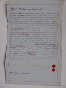
Document, Warrnambool Tramways-William Bell, C 1881
In 1858 a tramway was constructed to move goods between Warrnambool township and jetty on Lady Bay which was over a mile away The terminus was established on the southern side of Merri Street. and the track went around the edge of Lake Pertobe reserve. Large stores were also built near where the present railway station is situated to hold produce and carriages.This document is is a surety between John McDermit a saddler of Liebig Street Warrnambool along with Henry Phillips hay and corn dealer of Liebig Street Warrnambool, acting as surety in the amount of fifty pounds to William Bell a contractor to perform horse work for the Warrnambool tramways. for a period of one year, 1881-1882. This contract has a strong historical link to one of Warrnambool's earliest infrastructure projects . It contains the names of local people and provides an insight into the links between people and the types of work they undertook Pale blue lined paper with red lined outline.Hand written in black pen with names and some other words underlined in red. Two signatures on bottom right with red seal beside each. Witness signature below on left hand side. Of the four pages of the document , only the first page is used.Signed John McDermid, Henry Phillips. 1st October 1881.warrnambool,, warrnambool history, warrnambool tramways, william bell contract,, john mcdermid, henry phillips -
 Warrnambool and District Historical Society Inc.
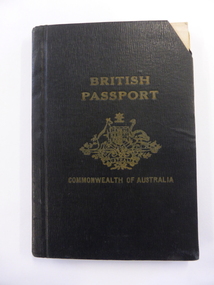
Document - Passport British Commonwealth of Australia, Australian Government, 1950s and 60s
This passport belonged to Alexander Swinton, a member of a prominent family in Warrnambool. The passport shows that he travelled extensively in Europe, U.S.A. and Central and South America. Alex Swinton’s forebears, William and Ann Swinton came to Warrnambool in 1854 and William Swinton opened a shop selling hardware, china and glassware in Timor Street Warrnambool in 1865. The Swinton businesses expanded in the 19th and 20th centuries and a Swinton furnishing store still exists today, making this store one of the oldest family businesses in Australia. Alexander Swinton (1907-1986) was the son of George and Florence Swinton of Merri Crescent Warrnambool. He attended Warrnambool Technical School in the early 1920s.This box is of interest as a memento of Alexander Swinton, a member of a prominent Warrnambool family. It also shows the type of passport issued to Australian citizens in the 1950s and 60s. These are two passport booklets joined together with white tape. Each has 32 pages and the booklet contains two black and white photographs, personal information (both printed and written), stamps and printed information from various countries and two inserted certificates. The front cover is black with printing and the image of the Australian Government crest.British Passport Commonwealth of Australiaalexander swinton, warrnambool, history of warrnambool, swinton, passport -
 Warrnambool and District Historical Society Inc.
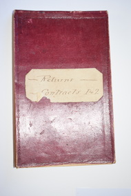
Administrative record - Warrnambool Water Trust Notebook, late 19th century (1892-1900)
This notebook appears to be the Warrnambool Water Trust Records of two contracts in 1892 . (The reference is written as 'W.W.Trust'.) The first contract, with the contractors, Coates and Reed, is for the excavation for settling tanks and clear water basin and a reservoir in Liebig Street and there are 60 pages giving details of these works - labour, masonry, concreting, fencing etc. The second contract with the contractor, William Kellas, is for the erection of a cottage and an engine shed and boiler room (7 pages). The Warrnambool Water Trust was set up in 1891 and the first project was the supply of water from the Merri River near Wollaston to a reservoir and tower in Liebig Street and this notebook concerns some details of this early water supply scheme. This notebook is of some interest as it supplies details of a late 19th century Warrnambool water supply scheme and so should be of value to local history researchers This is a notebook with a red leather cover and pages with printed headings and ruled red lines. The pages contain handwriting in black ink. The cover has a label (partly torn) with handwriting.Returns Contracts 1 & 2warrnambool water supply, warrnambool water board, 19th century water in warrnambool -
 Merri-bek City Council
Work on paper - Aerosol painting, synthetic polymer, gouache and colour pencils on Magnani paper, Luke King, Portrait, 2023
Luke King’s mixed media artwork Portrait (2023) was shown in the group exhibition Fever’Dreams at the Counihan Gallery in 2023. The group exhibition explored the slippery boundaries between abstract and figurative artwork, showcasing local artists with a strong connection to Merri-bek’s arts community. King uses portraiture to highlight the importance of gesture and facial expression in personal storytelling. Exhibition curator of Fever’Dreams, Mitchel Brannan, writes of King’s work: ‘King explores the profound capacity of the human face to convey emotions within the context of constraint. Through his art, King invites viewers to reflect on the complexities of human expression and the underlying dynamics of restraint within society.’ -
 Warrnambool and District Historical Society Inc.
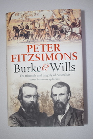
Book, McPherson’s Printing Group, Burke & Wills, 2017
This book gives a comprehensive and scholarly account of the ill-fated Burke and Wills expedition in Australia in 1860-1961. It is written by Peter Fitzsimons. The narrative includes the parts played in the expedition by two men who also had important connections to Warrnambool. One of these was Henry Foster who was Superintendent of Police in Swan Hill in the 1860s. In the early 1840s Henry Foster and Thomas Strong took up a run of 16.000 acres (St. Mary’s, Wangoom)). Their land was bounded on the south by the Southern Ocean, on the east by the Hopkins River, on the north by a fence from the Hopkins to the Merri Rivers and on the west by the Merri River and included the later surveyed site of the Warrnambool township. After Warrnambool was established Foster was able to retain 450 acres of the original run near Wangoom on the Hopkins River. He was active in Warrnambool’s early history, was a Justice of the Peace for the Belfast (Port Fairy) district in the late 1840s and his portrait is on the Warrnambool Pioneer Honour Board. The other local Warrnambool personality mentioned in the Burke and Wills book is Richard Bennett, in the 1860s, the manager of several large farming properties in N.S.W., including Canally Station on the Murrumbidgee where he came into contact with the expedition leaders. In the Warrnabool district Bennett was well-known from the 1870s to his death in 1904 as the proprietor of wool-scouring establishments on the Shaw River and at Dennington and as a public campaigner for local coal exploration, for artesian bore drilling and for numerous other projects, including the development of the local wool industry. His portrait is also on the Warrnambool Pioneer Honour Board. This book is retained as an account of an important event in Australia’s history and because it has several references to two men (Henry Foster and Richard Bennett) who also played a part in Warrnambool’s history. This is a hard cover book of 700 pages. The cover is black with gold printing on the spine and the dust cover has a cream background with light brown and black printing, black and white photographs and sepia-coloured sketches. The contents include a List of Maps, Dramatis Personae, Background and Acknowledgements, Prologue, 18 Chapters, Epilogue, Endnotes, Bibliography and Index. The pages contain maps, sketches and black and white and colour photographs. australian exploration, burke and wills expedition, richard bennett, warrnambool, henry foster, st. mary’s wangoom, history of warrnambool -
 Warrnambool and District Historical Society Inc.
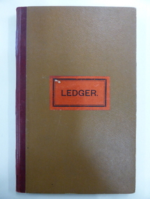
Document - Ledger, Standard Articles, Mid 20th century
This ledger contains original Warrnambool Standard newspaper cuttings of the eleven articles written by Henri Worland on the early history of Warrnambool. The subject matter includes the Post and Telegraph Office, Punts over the Merri and Hopkins Rivers, Transport in the Early Days, Early Exploration, Minjah Station and the History of the Breakwater. Henri Worland (1883-1972) was Warrnambool’s most important 20th century local historian. He was the Town Clerk of Warrnambool from 1918 to 1949 and his intense interest in Warrnambool’s history led him to collect and preserve a great amount of local history material. He wrote extensively on Warrnambool’s history and gave talks on the local radio station over a period of many years.These newspaper cuttings are of interest as examples of the many local history articles written by the important Warrnambool historian Henri Worland. The Warrnambool and District Historical Society has a collection of Worland’s original writings in his own handwriting. This is a ledger book with a brown-coloured cover with red binding. There is a label pasted on to the front cover with black printing on it. The ledger has indented alphabet tabs and the pages are ruled with red lines for ledger purposes but these have not been used. The ledger has been used to paste in original cuttings from the Warrnambool Standard newspaper (Henri Worland articles from the 1940s). One page contains two copies of old photographs. Some of the pages have been reinforced with staples and some pages have become detached from the binding. ‘Ledger’ henri worland, history of warrnambool -
 Warrnambool and District Historical Society Inc.
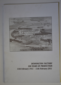
Booklet - Centenary History of Dennington Factory, Dennington Factory 100 Years of Production
Centenary History of the Dennington FactoryThis is a booklet of 24 pages. The front cover has a black and white photograph and black printing and the back cover has a colour photograph, a logo and black printing. The pages contain printed text and black and white and colour photographs. The booklet is stapled.non-fictionCentenary History of the Dennington Factorynestles factory dennington, fonterra factory dennington -
 Eltham District Historical Society Inc
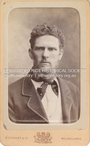
Photograph, Stewart & Co, Believed to be Samuel Shillinglaw, c.1885
Samuel Shillinglaw was born at Merri Creek, Victoria, September 27, 1848. He married Agnes McIntosh at Windsor, January 9, 1878 and died at Prahran, September 13, 1925. CARTE-DE-VISITE (cdv) 1857-1890 Cartes-de-visite (cdv's) are the most common form of photograph from the nineteenth century, generally measuring two and a half inches by four and an eighth inches (6.3 x 10.5 cm) when mounted, sepia toned, mounted on a card which was generally printed with the photographer's name and address on the back or beneath the portrait. - Frost, Lenore; Dating Family Photos 1850-1920; Valiant Press Pty. Ltd., Berwick, Victoria 1991marg ball collection, shillinglaw family photo album 1, 1880-1889, 1885, samuel shillinglaw (1848-1925), stewart & co photographers 217 & 219 bourke st east melbourne -
 Warrnambool and District Historical Society Inc.
Document, Gallagher, C 1881
In 1858 a tramway was constructed to move goods between Warrnambool township and jetty on Lady Bay which was over a mile away The terminus was established on the southern side of Merri Street. and the track went around the edge of Lake Pertobe reserve. Large stores were also built near where the present railway station is situated to hold produce and carriages. These documents relate to the contract to perform the horse work for the tramway for a period of one year. The horse work involved the transporting of goods by horse drawn tram trucks, all repairs to the tracks , shunting and delivery duties. The tramway operated from 7 am to 6 pm six days a week and a team of six horses was required to perform the work.The tramway was an important part of Warrnambool's infrastructure and history and the documents also include names of local people.001261.1 Pale blue lined paper with red lined outline.Hand written in black pen with names and some other words underlined in red. Two signatures on bottom right with red seal beside each. Witness signature below on left hand side. Of the four pages of the document , only the first page is used. 001261.2 Cream paper lined in blue with heavy black ink writing. A red seal attached beside the tenderer's mark and name. on right side of page. Witness's signature at bottom centre of page.001261.1 James Roberts hay and corn dealer ,Fairy Street Warrnambool, Martin Callaghanfarmer and contractor Raglan Parade Warrnambool. Daniel Gallagher, contractor of Warrnambool. September 1881. 001261.1 Daniel Gallagher .James Roberts Martin Callaghan September 12, 1881.warrnambool, warrnambool history, daniel gallagher, james roberts -
 Flagstaff Hill Maritime Museum and Village
Postcard - Postcard Folder, scenes, George Rose, Rose Stereographic Company, Rose Series Picturesque Views of Warrnambool Australia, 1880-1942
GEORGE ROSE 1861-1942: - George Rose was a well-known Victorian photographer, famous for his late 19th and early 20th century photography. He was born in Clunes, Victoria, and was in his 20th year when he founded Rose Stereograph Company in 1880. He took the opportunity of a popular trend of the times to produce stereographs, pairs of almost duplicate photographs that appeared in 3D when viewed in a handheld stereo viewer. By the 1920s, these lost their popularity, so he used his photographic skills to produce cards and postcards of scenes and people. The twelve photographs in the Rose postcard folders include locations connected to other items in our Collection, including the Valentine postcard folder in this set. The photographs are titled: - . The Avenue and War Memorial. Warrnambool. Vic. . The Blow-hole. Thunder Point. Warrnambool. Vic. . Botanical Gardens. Warrnambool. Vic. . Eagle Rock. Warrnambool. Vic. . The New Concrete Bridge and Breakwater. Warrnambool. Vic. . Liebig Street. Warrnambool. Vic. . Looking to Thunder Point. Warrnambool. Vic. . The Beach. Warrnambool. Vic. . Hopkins Falls. Warrnambool. Vic. . Shelly Beach. Warrnambool. Vic. . The Mouth of the Hopkins River. Warrnambool. Vic. . Panorama of Warrnambool, Vic. [Kepler Street towards Presbyterian Church on Spence St] The photographs in this postcard folder were taken between 1880 and 1942 by the renowned Victorian photographer George Rose. The locations match photographs and postcards in our collection that were taken at different times. A comparison between them shows the changes over time in the land and bay, the buildings and other structures, transportation and even the fashions of the times, building the story of our local history.Postcard folder, Rose Series, blue cover. One of a set of three containing images of Warrnambool and district before 1942. Green folder, textured cardboard folder containing a Z-folded strip of white matte photographic paper with six black and white photographs on each side. Titles are printed below the images. The folder is secured by placing two tabs into two slots on the back cover to hold the cover in place and create an envelope shape. Three horizontal lines are printed on the front for the receiver’s address. There is a logo of a long-stemmed rose on the left side and inscriptions on the front cover. The lithograph photographs were taken between 1880 and 1942 by well-known Victorian photographer George Rose and published by Rose Stereograph Company of Armadale, Victoria. The folder contains scenes of popular areas at Warrnambool and nearby locations including Lady Bay, the Port of Warrnambool, the Warrnambool Breakwater, the Viaduct, the Merri River Footbridge, the Hopkins River Mouth, and Proudfoot’s and the Fanny Nelson/Flett boathouses. Image: [Rose with rosebud and leaves] Printed: "Rose Series / Picturesque Views of / WARRNAMBOOL / AUSTRALIA" "PUBLISHED BY / ROSE STEREOGRAPH CO / ARMADALE. VIC." flagstaff hill maritime museum and village, great ocean road, shipwreck coast, warrnambool, flagstaff hill, flagstaff hill maritime museum, flagstaff hill maritime village, warramble, postcard, postcard folder, warrnambool scenes, picturesque views of warrnambool, picturesque views of warramble, lady bay, port of warrnambool, breakwater, warrnambool breakwater, viaduct, merri river footbridge, merri river suspension bridge, suspension footbridge, merri river mouth, hopkins river mouth, proudfoot's, fanny nelson, nelson's boatsheds, nelson's boathouse, boathouse, hopkins river boathouses, flett's boathouse, flett, george rose, image of a rose, rose series, rose stereograph co, rose stereographic company, lighograph, armadale victoria, lady bay beach, beach scene, lower light, concrete footbridge, 1922 footbridge, viaduct road, rose postcard, new concrete bridge, 1945, 1890, 1922, small footbridge, 1872 footbridge, 1872, merri river estuary, stingray bay, postcards -
 Warrnambool and District Historical Society Inc.
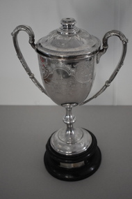
Trophy, Walker & Hall Ltd Silversmiths, Pritchard cup, 1920s
This is a trophy given to a Warrnambool Football Association by Harry Pritchard. He was a Warrnambool businessman who had the Warrnambool Sports Depot store in Kepler Street in the 1920s. The trophy was for the winner of the Warrnambool Wards Football Association. This was a Junior Association promoted by the Warrnambool Football Club and it existed from 1924 to 1930. It was proposed that the four Council Wards, Hopkins, Victoria, Albert and Merri each had a football team but it is not clear if all had teams and how many teams from other areas took part in the competition. The Pritchard Cup records that the Hopkins Ward Football Team won the trophy in 1926 and that Allansford, a team outside of the four wards, won in 1927. The records of the Allansford Football Club go back to the 1890s. This cup is of considerable interest, firstly as an attractive trophy in its own right and secondly as a memento of a football association connected with the Warrnambool Council Wards. Both the Council Wards structure and the Wards football association no longer exist. This is a silver cup with two ornamental handles, a slender stem and a silver base. The cup has a lid with a knob in the middle. The cup, lid and base are all heavily etched and patterned with scrolls, leaves and flowers. There is an inscription on one side of the cup. The cup sits on a circular brown wooden base which has a cloth or paste mixture affixed to the bottom. The wooden section has two silver plaques with inscriptions. There is a small piece of wood missing on the side of the top of the mount. ‘The Pritchard Cup presented to Warrnambool Ward’s (sic) Football Association by H. Pritchard.’ ‘Won by Hopkins Ward Football Club Season 1926’ ‘Won by Allansford Football Club Season 1927’ football in warrnambool district, harry pritchard, warrnambool 1920s, history of warrnambool -
 Warrnambool and District Historical Society Inc.
Financial record - Ledger: Warrnambool Water works Trust, Circa 1900
This ledger contains entries which relate to waterworks and associated expenses: construction, pumping schemes, water from stand pipes, meter rent arrears, interest payments, pumping scheme. Early residents in Warrnambool relied on tanks and wells for their water supply and in 1880 the first water supply scheme was implemented from a well on Cannon Hill. Using a windmill the water was pumped up and stored in a small reservoir nearby then piped to the corner of Timor and Liebig Streets where a stand pipe allowed the filling of water carts. Similar supplies were also installed at Albert Park, the Botanic Gardens and the Cattle markets and from 1893 to 1939 water was drawn from the Merri River. Drainage works commenced with the building of the Japan Street tunnel in 1856. The Warrnambool Waterworks Trust was the body responsible for administering these works.The supply and storage of fresh water and drainage of the area was an important factor in the development and sustainability of the town. This ledger provides an insight into the daily operations of this organisation. Large suede covered journal. Tan in colour with pink, green and white on edge of pages. Faded black stylised border around front cover. Inside front covers are patterned in green and tan. Printed sheet with Warrnambool waterworks Trust is pasted inside front cover. Warrnambool Waterworks Trust stamp on sheet inside front cover.warrnambool water works, warrnambool water supply 1900, warrnambool water works ledger 1900, warrnambool waterworks trust -
 Warrnambool and District Historical Society Inc.
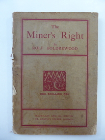
Book, The Miner’s Right, 1922
This book about the New South Wales goldfields was written by Rolf Boldrewood in 1890. It is retained because the author played a significant part in Warrnambool’s history. Rolf Boldrewood, the pen name of Thomas Browne, first came to the Warrnambool district in 1842, visiting the Bolden brothers’ property, Grasmere. He camped on the banks of the Merri River for about six months and described the area, including Warrnambool Bay, some years later in his book Old Melbourne Memories. In 1844 Thomas Browne established the property, Squattleseamere near Bessiebelle, north west of Portland. He remained there for ten years then moved to New South Wales. The last forty years of his life were spent writing and he became well-known for the classic Australian novel, Robbery Under Arms. This book is retained because it is a 19th century example of the writings of Rolf Boldrewood. He is important in Warrnambool’s early history as he was in the area in the early 1840s. His account of the area at that time is the most important one we have of the area that was later to be the site of the new settlement of Warrnambool.This is a soft cover book of 188 pages. The cover is brown with red edging and lettering and is partly detached from the binding. The spine is partly missing. The pages are dog-eared and there is some foxing. The text is printed in two columns to a page. Frank J. Donovanrolf boldrewood (thomas browne), bolden brothers in the warrnambool area, warrnambool history, the miners right -
 Warrnambool and District Historical Society Inc.
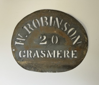
Functional object - Robinson Farm Labelling Stencil, c.1950
This stencil has been made to label packaged produce (wool bales, packaged meat etc) from a farm in Grasmere, near Warrnambool. The name, W. Robinson, suggests that this is William Robinson the son of James and Jane Robinson. James Robinson came to Australia in 1857 and he and his family farmed at Springvale at Hopkins Point, then at what was termed 'Manning's old Purnim Farm' on the Merri Rive at Grasmere (the Manning brothers, Frederick and John were early farmers in the district). The Robinson brothers, James and Stuart were well-known in the Warrnambool district as champion ploughmen. James's son, William married firstly Christina MacLennan and then Elizabeth Neale of Tooram, Allansford. William died in 1959 but the stencil was probably used on the property after his death. This farm stencil is of interest as a memento of farming at Grasmere in the first half of the 20th century.This is a metal stencil, oval in shape. It has letters cut out in the metal for stencilling purposes. It has been painted or sprayed and is rusted in places.W. Robinson 20 Grasmerewilliam robinson grasmere, manning's purnim farm -
 Warrnambool and District Historical Society Inc.
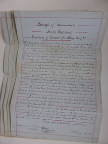
Document, Conditions of contract for Horse work Tramway Department, C1881
In 1858 a tramway was constructed to move goods between Warrnambool township and jetty on Lady Bay which was over a mile away The terminus was established on the southern side of Merri Street. and the track went around the edge of Lake Pertobe reserve. Large stores were also built near where the present railway station is situated to hold produce and carriages. According to these documents , the horses were required for many different tasks in the operation of the tramways including the moving of freight, removal of sand from the area, shunting of trucks and ballasting and repairing lines when necessary.The contractors had a list of conditions imposed including the provision of six horses of strong working ability and sufficient finances. The contract period was for 1 year and payment was monthly in arrears and hours of operation were from 7 am to 6 pm. These handwritten documents provide an insight into the type of work done in the early days of Warrnambool and the working conditions at the time. Five folded grey paper with red lines around edges. Written in black ink. Only front page of each piece has writing on it. 001262.1 Borough of Warrnambool Tramway Department Specification of Duties Contractor for Horse Work Signed William Bell 28/09/1881 001262.2 Borough of Warrnambool Tramway Department Conditions of contract for Horse Work. Signed Daniel Gallagher 20/09/1881 001262.3 Borough of Warrnambool Tramway Department Specification of Duties Contractor for Horse Work Signed Daniel Gallagher 20/09/1881. 001262.4 Borough of Warrnambool Tramway Department Specification of Duties Contractor for Horse Work Signed Michl Daly 5th September 1878 crossed out 001262.5 Borough of Warrnambool Tramway Department Conditions of contract for Horse Work Signed William Bell 28/09/1881warrnambool, warrnambool tramway, horse work, tramway contract -
 Warrnambool and District Historical Society Inc.
Book, Thalaba the destroyer Vol 1, 1821
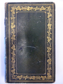
This book was written in 1801 in an epic poem form. It is unrhymed. It falls into the category of fantasy. The original owner of this book seems to have been John Bland. He is most important in the early history of Port Fairy and had a business in Port Fairy with John Cowtan (corn millers and general merchants). The Cowtans originally had land in the vicinity of the Cassady property of Boughton, Merri River (in Caramut Road near Cassady’s Bridge today) and were related by marriage to the Cassadys. A later owner of the book was William Anderson whose father came to the Yangery district in 1854 and established the property of Rosemount and William remained in this area until his death in 1909. The Andersons were related by marriage to the Cassadys and this book came to us following a clearance sale at the Cassady property, Boughton. This book is of great interest less for its literary content than for its ownership which probably dates back to the 1840s. It is associated with the families of Bland, Cowtan, Cassady and Anderson, all early settlers in Warrnambool and district.This is a brown leather-covered book of 271 pages. The cover has gold decorative borders and patterns and gold lettering. The pages are gilt-edged. The book is the fourth edition of volume one of a Robert Southey poem and has a Preface and Books 1 to 5 with Notes. The inscriptions are handwritten in black ink. One signature has not been deciphered. ‘Wm. Anderson’ ‘John Bland’ william anderson,, rosemount, william cassady, john bland, john cowtan, thalaba the destroyer, warrnambool, poem thalaba the destroyer, 19th century poems, robert southey books -
 Melbourne Tram Museum
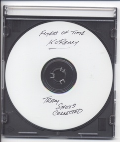
Photograph - Compact Diskette with photographs, Kevin O'Reilly, "Flyers of Time K'O'Reilly - Tram shots collected", 2012
CD (Compact Diskette for use in computers) (108mm diameter plastic disc with plastic case and cover) containing a series of aerial photographs of Ballarat (2) and Melbourne ( 15 ) Disc has the hi-resolution TIF files and jpg file. Files in order on CD: Ballarat 5 - copy sent to the Ballarat Tramway Museum - images on this record as tiff files. Ballarat - ditto Eliz St - see htd136 for image Kew Barkers Road - see htd137 for image Kew Burke Rd - see htd138 for image Kew Junction - see htd139 for image Merri Creek - see htd140 for image Richmond 6 - see htd141 for set of three images Richmond 7 - see htd142 for image Richmond - see htd141 for set of three images Richmond3- see htd141 for set of three images Royal Park 2 - see htd143 for image Sandringham - see htd144 for image Scotch - see htd145 for image Spencer - see htd146 for image St Kilda 1 - see htd147 for image St Kilda - see htd148 for imagetrams, tramways, melbourne -
 Warrnambool and District Historical Society Inc.
Document, Map: Lady Bay 1853, 1853
This is one of the earliest surveys and maps of Warrnambool harbor, Lady Bay. Being done in 1853, it shows the depths of the bay area marked in fathoms, currents and directions and areas of rocks around mouth of the Merri and the Western side of the bay as well as a large sand spit to the middle right of the beach region.. It also marks the large areas of seaweed and fuci in the outer bay area. It has the area of Pertobe Lagoon marked and shows the early tracks to the town. The engraving work was done by Tulloch and Brown, with Tulloch being one of the earliest engravers and lithographers in the state of Victoria. He arrived in Melbourne in 1849 and set up business with James Davie Brown in 1853 with Brown being a map engraver. They were awarded bronze and silver medals for their work at the Victorian Industrial Exhibition. He also worked in the vignettes on the Proeschel Map of Victoria.This map is of high historical and comparitive significance as it shows the Lady Bay area prior to the changes that have occurred in the last 160 years with the building of the breakwater. The issue regarding access to Lady Bay remains a current one. The engraver D Tulloch engraved some of the earliest scenes of the goldfields in Ballarat and as such has left a record of a very early and important era in Australian history. Rectangular cream paper with black text. Map area is outlined by fine black lined border. Key in top right hand corner and scale at bottom middle of map.Map is labelled Town of Warrnambool printed at top of map. Small logo at top right corner which has “Hydrographic Department” in circle around an anchor. Lady Bay Warrnambool Surveyed by John Barrow assistant surveyor Engraved by Tulloch & Brown in bottom right corner. Melbourne engraved by order of the legislative Council of Victoria in middle bottom.map, warrnambool, town of warrnambool map 1853, tulloch & brown map 1853, lady bay warrnambool,, warrnambool harbour, warrnambool breakwater, warrnambool beach -
 Warrnambool and District Historical Society Inc.
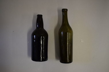
Bottles (2), Bottle, c. 1900
These two bottles were found by workmen building a new retaining wall on the north side of the Les O’Callaghan History House building in Gilles Street Warrnambool. The wall replaced one damaged beyond repair following a car accident in 2019. The building was erected in 1889 as the caretaker’s cottage in the Warrnambool Sea Baths complex (for most of its existence it had two swimming pools, a hot sea water baths building and a caretaker’s cottage). The water in the baths were pumped up from the ocean and, for the hot baths, heated on site. These baths were the municipal baths until the mid 1950s. The bottles may have originated from the one of the families residing in the cottage or from passers-by in the adjoining Merri Street or from patrons of the baths. They appear to be over 100 years old but there is no way the ownership of the bottles can be established.These bottles are of interest as archeological finds after repair works to the Les O’Callaghan History House. .1 A dark green (or black?) glass bottle with a hollowed out concave base, no stopper and a slightly chipped rim on the top. The bottle is stained inside. .2 A green glass bottle with a hollowed out concave base, a moulded top with no stopper and an elongated neck. The bottle is stained inside. warrnambool & district historical society, heritageworks warrnambool, les o’callaghan history house, warrnambool, history of warrnambool -
 Merri-bek City Council
Print - Digital image, Marshall White, Strip 1, 1987
Marshall White is a former Merri-bek resident and artist. He completed a Fine Art diploma at the National Gallery Art School in 1973. After a severe motorcycle accident left him with quadriplegia in 1977, he returned to university, earning a Master in Painting from what is now the Victorian College of the Arts. White is considered a pioneer of digital art in Victoria. He taught art to inmates at Pentridge Prison, which provided him with access to early computers. Using a Commodore Amiga, Marshall pushed the boundaries of digital art. Strip 1 represents an early contribution to what was, at the time, an emergent art form. Inspired by William Blake and Arthur Boyd, White’s work delves into psychological spaces, addressing themes such as the apocalypse and White’s distain of religion. White's work exemplifies resilience and the transformative power of creativity in the face of challenges.Purchased -
Warrnambool and District Historical Society Inc.
Document, Wollaston sale, 1919
This is a poster advertising the sale of part of the Wollaston Estate in Warrnambool in 1919. The sections for sale were Allotments 1, 18 and 19 which included the Wollaston Homestead. The original Wollaston property of 679 acres was selected by Thomas Manifold in the late 1840s. This land, on the northern side of the Merri River, near the Woodford Road was three kilometres from the Warrnambool town. The first farmer we know who leased the property was William Simpson. Walter Manifold inherited the property and he took it over in 1884. The swing bridge he built in 1890 still stands today. In 1919 the Closer Settlement Board of Victoria acquired Wollaston and 17 lots were sold to returned soldiers for farming purposes. By 1930 there were only five soldier settlers remaining. In 2009 further subdivision took place with lots sold for residential purposes. The homestead allotments were sold separately in 1919 with various owners of the homestead itself recorded since that time. This poster is of interest as it shows the areas of the Wollaston Estate which were sold in 1919. The history of this estate is well-documented and of importance in the history of Warrnambool. This is a sheet of paper with red and black printing and a map of the Wollaston Estate which is photo-lithographed. The sheet has been folded three times. It has some small tears at the top of the page. wollaston, history of warrnambool, walter manifold