Showing 3143 items
matching other areas
-
 Eltham District Historical Society Inc
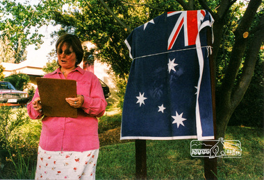
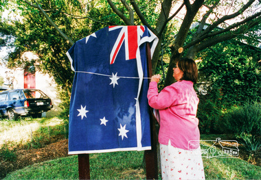
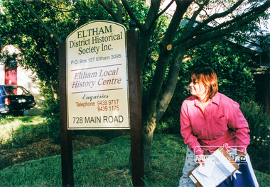
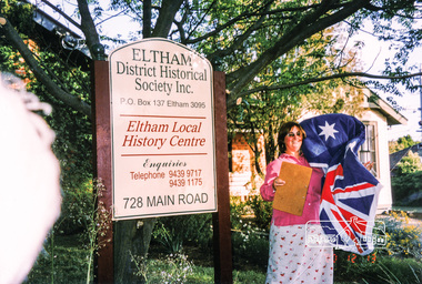
Photograph, Dedication of new sign at front of Local History Centre, 728 Main Road, Eltham, 13 Dec 2000, 13/12/2000
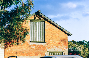
... known police residences in the metropolitan area (the other... known police residences in the metropolitan area (the other ...Held in conjunction with Christmas break-up BBQ Newsletter No. 136, January 2001 President's Report At our break-up barbecue local Nillumbik Councillor, Diane Bullen of Mt Pleasant Ward, unveiled the sign. She spoke briefly on the history of the building's use since 1860 and also reminded us that the National Trust has recognised the building as being one of two oldest known police residences in the metropolitan area (the other being at Heidelberg).Colour photographeltham, main road, police residence, local history centre, eltham district historical society, activities, cr. diane bullen, dedication -
 Eltham District Historical Society Inc
Photograph, Dedication of new sign at front of Local History Centre, 728 Main Road, Eltham, 13 Dec 2000, 13/12/2000
... known police residences in the metropolitan area (the other... known police residences in the metropolitan area (the other ...Held in conjunction with Christmas break-up BBQ Newsletter No. 136, January 2001 President's Report At our break-up barbecue local Nillumbik Councillor, Diane Bullen of Mt Pleasant Ward, unveiled the sign. She spoke briefly on the history of the building's use since 1860 and also reminded us that the National Trust has recognised the building as being one of two oldest known police residences in the metropolitan area (the other being at Heidelberg).2 colour photographseltham, main road, police residence, local history centre, eltham district historical society, activities, cr. diane bullen, dedication -
 Eltham District Historical Society Inc
Photograph, The old Stables at the rear of 728 Main Road, Eltham, 13 Dec 2000, 13/12/2000
... known police residences in the metropolitan area (the other... known police residences in the metropolitan area (the other ...Held in conjunction with Christmas break-up BBQ Newsletter No. 136, January 2001 President's Report At our break-up barbecue local Nillumbik Councillor, Diane Bullen of Mt Pleasant Ward, unveiled the sign. She spoke briefly on the history of the building's use since 1860 and also reminded us that the National Trust has recognised the building as being one of two oldest known police residences in the metropolitan area (the other being at Heidelberg).Colour photographeltham, main road, police residence, local history centre, eltham district historical society, activities, stables -
 Bacchus Marsh & District Historical Society
Map, General Plan for Water Supply Works, Shire of Bacchus Marsh 1887
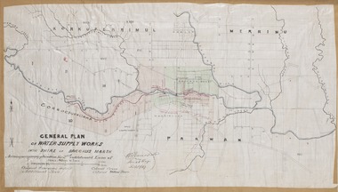
... includes the route of a proposed water channel in the Parwan area... includes the route of a proposed water channel in the Parwan area ...Debate about water supply and its planning and development took place in the Bacchus Marsh region from the 1850s through into the twentieth century. This plan was part of documentation to support an application for an additional loan of money from the Ministry of Water Supply to the Bacchus Marsh Shire Water Supply Trust. The plan includes the route of a proposed water channel in the Parwan area, and other features of water supply infrastructure such as the location of standpipes and gates are also shown on the plan.A single page paper map showing a general plan for the supply of water in the Bacchus Marsh area.The plan shows the route of the 'Main Channel' near the Werribee River and a proposed route for a Parwan Channel. The location of 'Dryden's House' near the Werribee River is also shown and the locations of land held by T. (Tom) Oliver and the Racecourse Reserve in Maddingley. Scale 40 chains to 1 inch. The plan is signed by Bacchus Marsh Shire Engineer, W.E. Standfield. The map is pasted into a bound volume containing 76 maps or plans in total. High resolution digital image stored on BMDHS computer network. General Plan of Water Supply Works in the Shire of Bacchus Marsh. Accompanying application for 2nd additional Loan. Original Waterworks district. Additional area. W.E. Standfield, 30/8/87.water supply, water supply maps, water supply bacchus marsh, irrigation, bacchus marsh victoria maps -
 Greensborough Historical Society
Document - Folder of Documents, Greensborough Inter Church Council 1990-2003, 1990-2003
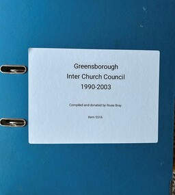
... other activities in the area including the annual Family Carol... and co-operatively organised many other activities in the area ...The Greensborough Inter Church Council was formed in 1989 at a meeting of the Greensborough Ministers Fraternal, with 8 churches initially involved. The Council organised ecumenical activities and services at Christmas and Easter and co-operatively organised many other activities in the area including the annual Family Carol Service. This folder contains agenda and minutes from some meetings, correspondence, advertising flyers and newspaper clippings on various activities. The collection is from Rosalie Bray, a past president and secretary of the group; it covers the years 1990-2003.Folder of documents, etc., housed in plastic pockets and arranged by year.greensborough inter church council, rosie bray -
 Eltham District Historical Society Inc
Photograph, Christmas break-up following dedication of new sign at front of Local History Centre, 728 Main Road, Eltham, 13 Dec 2000, 13/12/2000
... oldest known police residences in the metropolitan area... oldest known police residences in the metropolitan area ...L-R: Diana Bassett-Smith, Doug Orford, Keith Banks, Gwen Orford Newsletter No. 136, January 2001 President's Report At our break-up barbecue local Nillumbik Councillor, Diane Bullen of Mt Pleasant Ward, unveiled the sign. She spoke briefly on the history of the building's use since 1860 and also reminded us that the National Trust has recognised the building as being one of two oldest known police residences in the metropolitan area (the other being at Heidelberg).Colour photographeltham, main road, police residence, local history centre, eltham district historical society, activities, stables, doug orford, diana bassett-smith, gwen orford, keith banks -
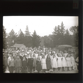 The Beechworth Burke Museum
Photograph - Lantern Slide, c1900
... in the socially beneficial effects of parks and other recreation areas... in the socially beneficial effects of parks and other recreation areas ...This glass slide depicts a group of school children standing in Queen Victoria Park (previously Beechworth Botanic Gardens), circa 1900. Queen Victoria Park was first secured in 1858 by the Beechworth Council with the assistance of the Central Board of Health (CBH). The CBH was a firm believer in the socially beneficial effects of parks and other recreation areas which is why they aided the council in securing the parkland. the council held a local competition for the design of the park and decided on a plan called "Better late than never" by Hungarian nobleman, J.A. Rochlitz. The first non-native trees were planted in 1861 and have since been heritage listed on the National Trust's register of significant trees. There are nine trees located in Queen Victoria Park that are currently on the National Trust's register. These are the Loblolly Pine, Italian Cypress, Shore Pine, and the Big Cone Pine. These trees hold significance as they date back to 1875 and show rare and localised examples of these types of species which are not seen in many other places in Victoria. The trees in the background of the glass slide depict a species of the pine tree and may be some of the trees still standing in Queen Victoria Park today.This glass slide captures social and historical significance as it not only captures a moment in time of these school children, but it also shows environmental significance for the heritage trees depicted in the background.burke museum, beechworth, lantern slide, slide, glass slide, plate, burke museum collection, photograph, monochrome, queen victoria park, indigo shire, school, j.a. rochlitz, beechworth council -
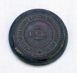 Orbost & District Historical Society
seal, 1928
... through Orbost and beyond. In the Orbost area a committee... through Orbost and beyond. In the Orbost area a committee ...On 23 December an act was passed to authorise the construction by the State (Victoria) of a line of railway from Orbost to Brodribb. Even as late as 1913 the railway was still expected to go through Orbost and beyond. In the Orbost area a committee was formed called the Bairnsdale to Orbost Railway Trust. The business of the trust was to acquire the land necessary for the railway and levy a rate on the property owners. The other cost to the area wanting a railway was the guarantee against loss in working expenses of the railway, the Orbost Shire had to provide up to £3000 per annum. The line was never constructed and the Bairnsdale to Orbost Railway terminated on the western side of the Snowy River. This item is associated with the history of the Orbost-Bairnsdale railway line and therefore reflects the role that the rail line played in the social and economic history of Orbost.A round copper disc with a metal seal on top. "Orbost to Brodribb Railway Construction Trust - 1928"seal railway orbost-bairnsdale-railway -
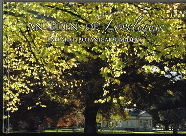 Ballarat Tramway Museum
Book, Friends of the Botanical Gardens, "An Eden of Loveliness - Ballarat Botanical Gardens", 2012
... Museum, fish hatchery and other features of the area... hatchery and other features of the area. Published ...Book - 6 sections, sewn hard cover with glued face sheets, 122 pages, full colour printing, art paper with table of contents, index, sources and maps, titled "An Eden of Leveliness - Ballarat Botanical Gardens". Provides a detailed illustrated history of the Ballarat Botanical Gardens. Looks at the creation of the gardens, the north and south foreshores, Lake Wendouree, Friends of the Botanical Gardens, Begonias, the Heritage trees and provides a timeline of development. Has some notes on the Ballarat Tramway Museum, fish hatchery and other features of the area. Published by the Friends of the Ballarat Botanical Gardens, 2012.On inside of the front cover "To the Ballarat Tramway Museum, Enjoy, from the Friends of the Botanical Gardens June 2016"trams, tramways, lake wendouree, botanical gardens, btm, gardens, begonia festival, local history -
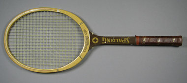 Tennis Australia
Racquet, Circa 1970
... AREA. On other side of shaft is printed: FIBER REINFORCED... FOR GREATER HITTING AREA. On other side of shaft is printed: FIBER ...A Spalding 'Challenge Cup Oversize Bow' wood tennis racquet. Model name printed across throat on obverse and reverse. Manufacturer's logo features along shaft on both sides of shaft. On left side of shaft is printed: HANDCRAFTED NORTH AMERICAN/ASH AND HARDWOODS and OVERSIZE BOW FOR GREATER HITTING AREA. On other side of shaft is printed: FIBER REINFORCED/THROAT, BOW, AND SHAFT. Grip wrapped with leather printed with manufacturer name. White plastic butt cap features maker logo. Materials: Wood, Metal, Lacquer, Glue, Ink, Nylon, Paint, Plastic, Leathertennis -
 Glen Eira Historical Society
Book - St. Mary’s Church, Caulfield
... and some other notable areas in the church and furniture...., the honour roll and some other notable areas in the church ...Two copies of St. Mary’s Anglican Church, Glen Eira Road, Caulfield. Souvenir of 50 years 1858-1908. Includes history of the church, home and foreign missions, list of memorials and gifts in the church. Also photos of parishioners the church and interior, the vestry and Rev. A.J.H. Priest and Mrs. Priest, and Rev. H.B. Macartney and Mrs. Macartney. Two copies of St. Mary’s Anglican Church, Glen Eira Road Caulfield. Souvenir record of 60 years 1858-1918. Includes history of the wooden church, names of the early parishioners, the first, third and fourth incumbencies, the jubilee school, Sunday school, choir and organ, daughter churches and St. Mary’s a mission parish, and the last decade from 1908 to 1918. It also has a list of organisations and office bearers. Manila book has all photos omitted. There are twelve photos including St. Mary’s choir, a group of St. Mary’s Sunday school teachers, missionaries, curate, organist and verger, Rev. H.T. Langley and Mrs. Langley. Three leaflets from St. Mary’s Church, the first 100 years of the church building 1871-1971. Leaflets detail the centenary services and functions. It has a list of office bearers and vicars, named windows, the honour roll and some other notable areas in the church and furniture.watts thomas, caulfield, glen huntly road, balaclava, hawthorn road, the black chapel, st. mary’s, park street, porter mrs., pennington mr., pennington mrs., stephen wilberforce, stephen mrs., hart mrs., cox peter, bunton barbara -
Dutch Australian Heritage Centre Victoria
Herring Cart (haringkarretje)
... at both ends and a handle for pushing the cart. At other end... ends and a handle for pushing the cart. At other end ...Souvenir, home made with jigsaw, celebrating Dutch national delicacy. These carts are seen in streets and markets throughout the Netherlands during herring season.Balsa wood model of a herring cart with 2 spoked wheels. Main body has two compartments covered with circular lids, surmounted by rack holding 3 herring barrels in the Dutch national colours of red ,white and blue. At top of rack a fish-shaped advertising salt and sour herrings. Main body also has a support at both ends and a handle for pushing the cart. At other end is preparation area with a hole for discarding fish waste into the bucket which is hanging below. A checked tea towel hangs off the preparation area. Next to the cart is white pot with a lid possibly for holding chopped onions. -
 Kiewa Valley Historical Society
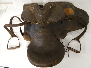
Saddle Horse Stock, Circa 1950
... /Bogong High Plains and other rural cattle producing areas.../Bogong High Plains and other rural cattle producing areas ...This stock horse saddle was probably used in the mid 1900's. This was the period when cattle mustering was at its prime. The movement of cattle was by mounted stock horse only and not by other methods. Northern territory cattle stations in the late 1900's started to use helicopters for "cattle control". In the KIEWA Valley/Bogong High Plains and other rural cattle producing areas required well trained stock horses and stockmen for cattle control. It is only in the later 1900's that motor bikes and four wheeled quad-bikes have taken over, in part, from the mounted stockman.This horse saddle is very significant to the Kiewa Valley because of the early introduction of cattle stations in what initially was regarded as a semi remote location. The maintenance of cattle in the Kiewa Valley is and was an important requirement. A good stock horse saddle as and is important, especially during the period when cattle were grazed on the Bogong High Plains. The mustering and and moving cattle from the valley pastures to the high country was a demanding and dangerous exercise requiring "sure footed" stock horses.The "good" saddle was a vital part of this cattle mustering. A scientific study started in 1947 to study the impact of grazing cattle on the natural Alpine and sub Alpine vegetation found grazing cattle had an adverse affect on the natural Alpine and sub alpine vegetation, and grazing on the plains was stopped by the Victorian Government in 2005.This "camp draft" in the High Plains could take up to six weeks.This all leather "stock horse" saddle shows plenty of wear. It is in "full harness" configaration with stirrups and leg protectors horse, country, leather, gaiters, high, grazing, cattlemen, laces, studs -
Federation University Historical Collection
Book, Public Transport Users Association Notes and Press Clippings, 1991-2010, 1991-2010
... Vol 6 - Other Ballarat Transport Issues, 2001-2008 .7) Public... Public Transport Ballarat & Region Vol 8 -Other Regional Areas ...Used by the local branch of the Public Transport Users Association.Seven plastic covered display books with press clippings, media releases and notes concerning the Public Transport users Association in the Ballarat Region. .1) Public Transport Ballarat & Region Vol 1 - National Express Review, 1999-2001 .2) Public Transport Ballarat & Region Vol 2 - Press Cuttings, 2001 - 2002 .3) Public Transport Ballarat & Region Vol 3 - Press Cuttings, 2002-2003 .4) Public Transport Ballarat & Region Vol 4 - Press Cuttings, 2004-2005 .5) Public Transport Ballarat & Region Vol 5 - Press Cuttings,2006-2012 .6) Public Transport Ballarat & Region Vol 6 - Other Ballarat Transport Issues, 2001-2008 .7) Public Transport Ballarat & Region Vol 7 - Creswick, 2000-2010 11729.8 Documents Transport Public Transport Ballarat & Region Vol 8 -Other Regional Areas Baker, Jean 2000-2010 11729.9 Documents Transport Public Transport Ballarat & Region Vol 9 - Closure of North Melbounre Station and the impact on Ballarat Commuters Baker, Jean 2014 Book Transport Driving the Fast Train Further: Integreated Public Tranpost Across All Victoria Everingham, Wendy and McPherson 1999-2001 Documents Transport Public Transport Ballarat & Region Vol 3 - Press Cuttings Baker, Jean 1999-2001 transport, linking victoria, railway, fast rail, ballarat corridor, bendigo corridor, traralgon corridor, geelong corridor, warrnambool corridor, level crossings, country rail lines, ararat rail line, trains, jean baker, hedley thomson, coach, national express review, mildura review, public transport corporation, maryborough to ballarat passenger rail service, mildura country rail, john parkin, john mclean, steve bracks, airport rail, john barnes, buses, alstrom, rail crossings, dove downey, curtis street bus terminal, bus interchange, ballarat railway stations, trams, creswick, creswick railway station, ararat, wimmera, mallee, maryborough, clunes, talbot -
Bendigo Historical Society Inc.
Postcard - BENDIGO POSTCARDS x 5
... of Bendigo (although it housed children from other areas as well... in the diocese of Bendigo (although it housed children from other areas ...Five sepia postcards of Bendigo - St. Paul's Church, Bendigo; Queen's Reserve, Bendigo; St. Andrew's Presbyterian Church and School, Bendigo; The Orphanage, Bendigo; and Conservatory Gardens, Bendigo. 'C & L Series' and 'Semco Series', Bendigo. Early 1900's. Unused, and no writing on the reverse of the postcards. May have been connected with the Waterworth family. St. Paul's Church: St Paul's Cathedral, Bendigo was built in stages. The nave was built in 1868, the tower in 1872-73 and the transepts and sanctuary in 1926-27. Robert Love was the architect, although the final stage was supervised by architects Gawler and Drummond. Cathedral status was transferred from the original cathedral All Saints to St Paul's in 1981. The Gothic style cathedral is constructed of red brick with stone dressings. It has a simple cruciform plan comprising a six bay nave, transepts and sanctuary. A tall tower centrally located at the west end dominates the exterior. The peal of eight bells was cast by Meares and Co of London and installed in 1873. The interior features elaborately cusped roof principals; an organ by Alfred Fuller built in 1883 with a console and pipes added later from St Andrew's Cathedral, Sydney; and notable stained glass by Ferguson, Urie and Lyon. St Paul's Rectory was built in 1885 to a design by the architect W C Vahland. The Parish Office and Hall was built as a Sunday School in 1898 to a design by F W Lehmann. Queen's Reserve: Now known as part of the Bendigo Botanic Gardens, Rosalind Park, Pall Mall. In 1851, the gold rush transformed the area and eventually the mullock heaps became the most prominent public park in Bendigo. Rosalind Park was added to the Victorian Heritage Register in 2000 for its historic, archaeological, aesthetic, scientific (botanical) and architectural significance to the state of Victoria. The statue of Queen Victoria dates to 1903. St. Andrew's Presbyterian Church: Opened in 1859 as part of the Presbyterian Church, St. Andrew's. Union of the Presbyterian, Methodist and Congregational Churches in 1977 saw this church join the Uniting Church. Located in Myers Street, Bendigo. The Orphanage: The Convent of the Good Shepherd, Bendigo was established in 1905. It was established at the request of the Bishop to cater for children in the diocese of Bendigo (although it housed children from other areas as well). It was also known as St Aidan’s Orphanage, and was the only Good Shepherd Convent in Australia to care for boys. The section named St Aidan’s accommodated girls aged up to around 16 years, as well as boys aged up to around 11. Maryfields housed girls and women aged from around 15 years. The Convent ceased to operate as a residential facility for children in 1981. A number of women with disabilities remained at the Convent until it closed in 1984. Conservatory Gardens: Now known as part of the Bendigo Botanic Gardens, Rosalind Park, Pall Mall. In 1851, the gold rush transformed the area and eventually the mullock heaps became the most prominent public park in Bendigo. Rosalind Park was added to the Victorian Heritage Register in 2000 for its historic, archaeological, aesthetic, scientific (botanical) and architectural significance to the state of Victoria. The Conservatory Gardens feature an ornate 19th century Conservatory building, erected in 1897 - this was the last building of its type in a public park in Victoria. bendigo, gardens, buildings, chinese, church -
Mt Dandenong & District Historical Society Inc.
Audio / Transcript, Mabel Badenhop, c1972
... as well as many other homes in the area. ... as well as many other homes in the area. mabel badenhop thomas ...Thomas, Eliza and eight children (Kate, Eva, Eliza, Florence, Mabel, Alice, Frederick and William) lived at Mountain Grange. Thomas was employed as an engineer for Lillydale Shire, but died suddenly in 1888, aged 42. About 1910, Eliza and her daughter Florence opened the Kalorama Post Office. Eliza died in 1918. Born in 1881, Mabel Badenhop nee Hand was the youngest child of Thomas and Eliza Hand of Mountain Grange. She was 7 years old when her father died. Mabel married Ernest Badenhop in 1905 – Pete the Swede played violin at the wedding. Ernest Badenhop was a builder & built Halcyon and Hygeia for the Dunbars as well as many other homes in the area. mp3 audio tape interview conducted by John Lundy-Clarke with Mabel Badenhop runs for16.33 minutes. 8 page transcript of tape. mabel badenhop, thomas hand, ernest badenhop -
 Orbost & District Historical Society
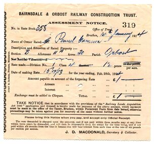
assessment notices, 1913 1914 1926
... on the property owners. The other cost to the area wanting a railway... on the property owners. The other cost to the area wanting a railway ...In the Orbost area a committee was formed called the Bairnsdale to Orbost Railway Trust. The business of the trust was to acquire the land necessary for the railway and levy a rate on the property owners. The other cost to the area wanting a railway was the guarantee against loss in working expenses of the railway, the Orbost Shire had to provide up to £3000 per annum. Even as late as 1913 the railway was still expected to go through Orbost and beyond. 635.3 is to Albert Trewin for 158 acres at Orbost. 635.2 is to Robert P. Cameron for 120 acres in Orbost and 635.1 is for Penuel Cameron for 20 acres in Orbost. Robert Pullar Cameron was a Shire Councillor for many years. He married Penuel Hossack and had a family of James, Flora, Penuel and Alex. Albert and Hazel Trewin farmed at Jarrahmond, just outside Orbost on the B Road. This item is associated with the history of the Orbost-Bairnsdale railway line and therefore reflects the role that the rail line played in the social and economic history of Orbost.Three paper notices of assessment. 635.1 is white with black print. 635.2 and 635.3 are pink with black print. All have hand-written details. They are from the Bairnsdale and Orbost Railway Trust.orbost-bairnsdale-railway cameron-robert-pullar trewin-albert assessment-notices -
 Surrey Hills Historical Society Collection
Book, Alan Judge Holt (deceased), Pre-Suburban Surrey Hills 1839-1883, 1989
... and other organisations in the area. Alan used this information..., churches, clubs, businesses and other organisations in the area ...Author: Alan Judge Holt amassed a significant collection of historical material related to the Surrey Hills area. Born in Moonee Ponds in 1912 to Edmund Holt and Ellen Ruby Sutton, he married Edna Jean Pallot in 1937. They lived at 62 Broughton Road, Surrey hills, had 3 sons and were strongly associated with the Surrey Hills Methodist Church. Alan was Secretary of the Victorian Lands Department and in his spare time recorded the occupancy of every property in Surrey Hills and Mont Albert at the beginning of each decade from 1890 to 1980. His collection of files and individual cards covers people, places, churches, clubs, businesses and other organisations in the area. Alan used this information to give talks and tours of the area and gifted his material to the local history collection through Jocelyn Hall.Unpublished manuscript / notes written by Alan Holt about settlers in and around Surrey Hills bound in-house. It is supported by maps showing landowners over various years from about 1840-1885(mr) henry jamieson, (mr) ken hall, (ms) edna holt, (mr) frank bamford, (mr) harrison buchanan, scouts, grange hill, wattle park, round hill, bona vista, mount albert, barton street, (mr) john raeburn, (mr) edmund holt, (mr) james dunn, butter merchant, mont albert road, elgar road, view hill, new street, surry mont, delany's hill, reservoir hill, riversdale road, middlesex road, surrey hills, (mr) aldo massora, aborigines, damper creek, back creek, west creek, kooyongkoot creek, (mr) john gardiner, (mr) chas mullins, (mr) henry elgar, (mr) robert campbell, (mr) alexander dyce, (mr) robert brooks, t budds payne, (mr) hugh glass, (mr) patrick trainer, w virtue, (mr) t fulton, (mr) john crimp, (mr) w dempsey, (mr) w e stanbridge, (mr) james atkinson, j porter, j collings, w edde, (mr) orlando fenwick, (dr)(mr) l l smith, (mr) j h knipe, (mr) george cockcroft, (sr) (mr) john martin kleinert, w morton, d delaney, a moeller, (mr) william smith, (mr) e.p.s.sturt, (mr) thomas blood, (mr) patrick mornane, (mr) henry de carle, w craig, j hill, w oliver, j keogh, a laing, vineyards, toll gates, (mr) david staig, (mr) phillip kleeper, (mr) goyder usher, (mr) james lawler, (mr) w.e. stanbridge, (mr) gideon rutherford, c a f mater, j gadsby, w h wrixon, e h lamont, i ainger, (mr) james henty, (mr) henry henty, w freemantle, w palmer, beckett park, maranoa gardens -
 Surrey Hills Historical Society Collection
book, Early history of Wattle Park, Surrey Hills 1853-1915, 1984
... and other organisations in the area. Alan used this information..., churches, clubs, businesses and other organisations in the area ...Author: Alan Judge Holt amassed a significant collection of historical material related to the Surrey Hills area. Born in Moonee Ponds in 1912 to Edmund Holt and Ellen Ruby Sutton, he married Edna Jean Pallot in 1937. They lived at 62 Broughton Road, Surrey hills, had 3 sons and were strongly associated with the Surrey Hills Methodist Church. Alan was Secretary of the Victorian Lands Department and in his spare time recorded the occupancy of every property in Surrey Hills and Mont Albert at the beginning of each decade from 1890 to 1980. His collection of files and individual cards covers people, places, churches, clubs, businesses and other organisations in the area. Alan used this information to give talks and tours of the area and gifted his material to the local history collection through Jocelyn Hall.A spiral bound manuscript which includes a physical description of Wattle Park as well as covering aboriginal occupation, pastoral and timber cutting, the original purchasers and locations of neighbouring farms.back creek, wattle park, delany's paddock, cleary's paddock, blood's paddock, conran's paddock, udimore lodge, (mr) george thomas usher, (mr) orlando fenwick, phoenix grange, (mr) john filson, (mr) denis delany, (mr) john crimp, (mr) james atkinson, (mr) john lawler, (mr) henry de carle, (mr) walter craig, (mr) daniel dunn, (mr) frederick goyder, (mrs) eliza welch, metropolitan tramways, d h dureau, (mr) robert beckett, (mr) alexander gerald proudfoot, (mr) james conran, (mr) thomas blood, (mr) william smith, payne and glass -
 Eltham District Historical Society Inc
Photograph - Digital Photograph, Alan King, Kinglake National Park, 27 March 2008
... ; then Wombelano Falls in Yea and other areas were added. In 1970 the park...; then Wombelano Falls in Yea and other areas were added. In 1970 the park ...Fern gullies around Jehosaphat Gully Covered under National Estate. Published: Nillumbik Now and Then / Marguerite Marshall 2008; photographs Alan King with Marguerite Marshall.; p125 The magnificent Kinglake National Park, fringing Nillumbik’s north, is the largest national park close to Melbourne. Thanks to the vision and hard work of a band of local people, the park was created from what was rapidly becoming degraded land. Seeing a threat to Kinglake’s indigenous flora and fauna, several prominent local people campaigned for a national park, which was established in 1928.1 Since then, the park has grown through donations and acquisitions of land, from around 13,800 acres of land (5585ha) to 22,360 hectares. The Sugarloaf and Everard Blocks – of almost 8000 hectares – stand in Nillumbik and the park extends into Mitchell and Murrundindi Shires and the City of Whittlesea. Mt Everard commemorates William Hugh Everard, State member for Evelyn when the park was established. Before 1928, European settlers had degraded the Kinglake area, which was named after the celebrated English author and lawyer, Alexander William Kinglake. Remains of gold shafts and diggings in the park are reminders of Kinglake’s first settlers, who hoped to strike it rich at the gold diggings. But like other gold fields in this shire, they proved not very lucrative and soon timber cutting replaced mining in importance. However, before long, the accessible timber supply ran out, so in the 1920s agriculture took over – particularly potatoes and berry fruits – which involved large-scale clearing.2 The park’s instigator was retired Melbourne University Professor of Music, William Laver.3 As chair of the Kinglake Progress Association he began negotiations to have crown lands on the southern scarp of the Great Dividing Range reserved as a national park. Even before the park was proclaimed, from 1927, KPA members cut tracks to the major scenic points. Professor Laver was one of several people who gave land for the park, donating around 50 acres (20ha), including the Jehosaphat Gully.4 Laver chaired the park’s first Committee of Management, which raised money to employ a ranger and provide facilities, including tracks and roads for fire protection vehicles, toilets and shelters. The committee charged fees for firewood collection, some grazing of livestock, and visitor entrance, and obtained small State Government and Eltham Shire grants. In 1957 the State Government provided revenue for national parks. Then, in 1975, the State Government took over the management and the Committee of Management became an advisory committee, which disbanded in 1978. Originally, the park covered crown land in the Shires of Eltham and Whittlesea; then Wombelano Falls in Yea and other areas were added. In 1970 the park extended into the Shires of Eltham, Healesville, Whittlesea and Yea.5 Bush fires have been an ongoing problem. In 1939 hundreds of eucalypts and acacias had to be sown around the Jehosaphat Gully to rejuvenate the forest. To manage bushfires, the Committee of Management, then the State Government, worked closely with the Forestry Commission, shire councils and local fire brigades. Early national parks focussed on recreation. But by the 1980s, conservation, education and scientific research became more important, playing a vital role in preserving representative samples of the natural environment. Each year many thousands of people use the park’s extensive network of walking tracks amongst the protected plant and animal life as well as camping, cycling and horse riding. The park, along the slopes of the Great Dividing Range, has lookouts revealing magnificent views of the Melbourne skyline, Port Phillip Bay, the Yarra Valley and the You Yangs. Vegetation in the Masons Falls area includes messmate forest, Austral grass-trees, ferns and Hazel Pomaderris. In spring, orchids, lilies, everlasting daisies, correas, grevillea and heath appear. Around Jehosaphat Gully are wet and dry forest, fern gullies and banksia. Animal life includes wallabies, kangaroos, koalas, echidnas, possums, gliders and bandicoots. Male lyrebirds can be heard mimicking in the Jehosaphat Gully, particularly in the Everard Block in winter.This collection of almost 130 photos about places and people within the Shire of Nillumbik, an urban and rural municipality in Melbourne's north, contributes to an understanding of the history of the Shire. Published in 2008 immediately prior to the Black Saturday bushfires of February 7, 2009, it documents sites that were impacted, and in some cases destroyed by the fires. It includes photographs taken especially for the publication, creating a unique time capsule representing the Shire in the early 21st century. It remains the most recent comprehenesive publication devoted to the Shire's history connecting local residents to the past. nillumbik now and then (marshall-king) collection, kinglake national park, jehosaphat gully -
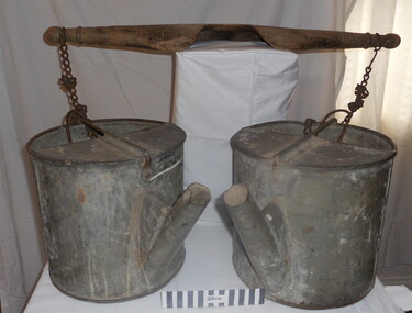 City of Moorabbin Historical Society (Operating the Box Cottage Museum)
Tool - Chinese Market-Gardener's Watering-Cans
... , (nearly all single men), were forced to seek other occupations... building in the East Melbourne area, whilst others went into market ...Chinese market-gardener’s watering-cans on a wooden yoke. This item was authenticated by the Bendigo Historical Society, and is said to be quite rare. It consists of two large galvanized watering-cans each with a pouring spout, suspended by chains from a well-used wooden yoke. The cans would each have been filled with water, then carried a distance into the market garden and used to water crops. The cans and yoke alone are very heavy, one can only imagine how heavy they were when filled with water.As profits from the gold-fields petered out the Chinese immigrants, (nearly all single men), were forced to seek other occupations. Many moved into furniture building in the East Melbourne area, whilst others went into market gardening . A significant number of Chinese men, realising the potential of the sandy, fertile soil, with a good supply of water, in the Shire of Moorabbin, leased tracts of land in that area to establish a market garden and grow produce for the increasing population of MelbourneAfter the Dendy Special Survey in1841in Brighton, Victoria, the first sale of Crown Land, taking in the whole Shire of Moorabbin, occurred in 1852. These allotments of land were eagerly bought up - some by speculators - although many were either worked by the owner, or leased out as market gardens and "fruit gardens", (orchards). Chinese market-gardener’s watering-cans suspended by chains on a wooden yoke. This item was authenticated by the Bendigo Historical Society, and is said to be quite rare. It consists of two large galvanized watering-cans each with a pouring spout, suspended by chains from a well-used wooden yokebrighton, gardeners, bentleigh, orchards, vegetables, dendy henry, market gardens, chinese settlers, pioneers moorabbin, water wells, creeks -
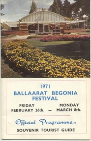 Ballarat Tramway Museum
Memorabilia - Event Materials, The Ballaarat Begonia Festival Association, "1971 Ballaarat Begonia Festival - Official Programme Souvenir Tourist Guide", 25/08/2002
... photo of the gardens area. All other photos are black and white... a half full cover photo of the gardens area. All other photos ...Twenty 28 page printed program with a four colour cover printed on heavier stock for the 1971 Begonia Festival. Includes details of the organisers, a welcome to the City, Sovereign Hill, Official programme, (26/2 to 8/3), photos and details of the various tourist attractions, statistics about Ballaarat, some details of the facilities, churches, Royal South St and industry. The main text is printed in black ink, the centre 16pp consists of the programme printed in blue ink. Front page has a half full cover photo of the gardens area. All other photos are black and white. On page 31 is a small photo of a bogie tram at Mt. Pleasant and that these trams were 'doomed' and would be replaced by buses. On rear cover is a map of Ballarat in pink ink, showing the tram and bus routes. Second copy held - added 28/12/2002. See Reg Item 5042 for an advertising brochure for the festival. High quality scans added 15-02-2011 following use in the 60 years Begonias web site article - seven images of various pages. trams, tramways, tramways, begonia festival, festival program -
 Eltham District Historical Society Inc
Film - Video (VHS), Diamond Creek Fire Brigade, c.1955-1987
... the savagery of bushfires. But due to competition from other areas more... the savagery of bushfires. But due to competition from other areas more ...Combination of three movie films. Movie One (1950s): 00:00 – 13:14 Black and white footage of Diamond Creek firemen practising in Diamond Street in the 1950s for forthcoming demonstrations of abilities. Mentions of Gordon Brandy and Joe Hislop Running out hoses from old hose reels along Diamond Street, Diamond Creek Displays from various brigades running out and connecting hoses. Also scenes from the 1950s of Diamond Creek Fire Brigade competing in various locations around Victoria and Tasmania. Mentions of Brigade members Dave Kidd, Bruce Hackett, Ron Kirkbride, Jack Marks, Graham Upton who are prominent in these events. Members of Kyneton Fire Brigade also present. Members competing in running out hose reels, connecting hoses togethers and to hydrants then climbing towers to direct water from hose or at a target hanging above the road. Diamond Creek members identified wearing a diamond on their chest and back. Includes scenes of Scottish pipe bands at the events and significant crowds of spectators. Footage of Mel Stone and Beryl Marks, Stan Redpath and Ron Kirkbride, then Ron Kirkbride and Eric Holt viewing flower displays. Film changes to colour at Diamond Creek oval for practice with fire engine entering oval. Members depicted include Bill May, Jack Sinclair, Jim Cox, Bob Beale, Dave Kidd, Bruce Hackett and Captain Clarrie Stone. Reverts to black and white in the 1950s where the Brigade joins forces with the Diamond Valley Community Hospital for a Gala Day on the Diamond Creek Oval. Changes to colour again, possibly same event and scenes of children on bikes and scooters or with prams and carts racing around the oval. Mention of young lad Brian Laurie who has his own fire truck. Dart throwing, pony rides. Scenes with Dr Don Cordner, Gus Lyons, Vic Cohn (?) and spinning wheel and Diamond Creek School children entertain a large crowd with Maypole dancing. Movie Two (1950s): 13:25 – 19:00 This black and white film was taken by a TV film crew in the 1950s depicts a typical call out for the Diamond Creek Fire Brigade. In this case the careless action of a member of the public throwing a lighted match from a car, which can cause extensive damage. Footage features the Shire of Eltham War Memorial tower at Kangaroo Ground before it was modified with a fire spotter’s cabin. Discusses fire spotting operations from the tower. Shows a fire spotter walking around the top of the tower. A fire is detected, and the information is relayed to the nearest fire station, in this case, Diamond Creek. The telephone call is received, and the alarm sounded. Captain Clarrie Stone and firemen May and Shaw leave their workplaces and prepare for action. Scenes of running across the Main Hurstbridge road showing the shops (Shell service station and Chemist prominent). Scenes entering the fire station which has a pictorial warning covering the entire door “Only you can prevent forest fires – If you’re careless – we’re homeless!” Eric Holt pinpoints the location of the fire while Captain Clarrie Stone and Fireman Shaw take note. The advance vehicle (an FE Holden ute, rego GTE-696) leaves to assess the extent of the fire. Having assessed the fire, Fireman Shaw communicates with base showing radio with call sign VL3JZ. Eric Holt takes the call. In the meantime, Captain Clarrie Stone and Fireman Shaw undertake some limited action to address the fire. Firemen Bill May, Jim Bates and Hugh Bar (?) man the tanker. A photo portrait of Queen Elizabeth is visible hanging on the wall. They are later joined by Firemen Jim Cox, Eric DeBuse (?) and Jack Marks. The tanker is seen departing the station and diverging off before the bridge. Captain Clarrie Stone and Fireman Shaw are seen pumping water on the flames with hand pumps when the tanker arrives. The hose is unreeled, and water turned on the flames. Jack Sinclair joins the action. Jim Cox directs water to the high stuff. The fire put out, Jack Marks and Eric DeBuse wind in the hoses and the team head back to town. It’s peaceful again at the memorial tower. Movie Three (1969-1987): 19:14 – 34:34 Colour film “Fired with Dedication”, Country Fire Authority Victoria, produced by I.L. Wadeson, Commentary by A.M. Hem. Credits with CFA Victoria emblem and then placed over a view of an old-style ladder engine. Opens with the scene of a fire engine outside the Diamond Creek Fire Station then various trophies reflecting the competition success of the brigade in various track and disciplined events. Two trophies shown of particular pride to the brigade were for first place in the Torchlight Procession at the State Championships in Mildura in 1986 and also at Swan Hill in 1981. Still photo scenes of ex Captain Clarrie Stone, Brigade Captain for 21 years; ex Captain Jack Marks, 10 years; ex Captain Ian Douglas, 10 years. Cuts to scene of radio control room, January 1969, and news of a fire on the northern side of the township of Diamond Creek. With scenes of flames in bush, the narration explains that until the early 1960s the area was an orchard district which protected the town against the savagery of bushfires. But due to competition from other areas more suitable for orcharding and easier transport to Melbourne the district could no longer remain competitive, and orchards were replaced by grassed areas, which together with the bush areas were a feeding ground for fire. On 8th January 1969, high temperatures and strong north winds, were, with the carelessness of some individual all that was necessary to produce the worst fire the district had seen. Cuts to scene of blackened fields and cattle - Hundreds of hectares of grass land were blackened, and cattle had to be transported to other areas for agistment. Scene of destroyed buildings in the township – 13 houses and the public hall in the town were destroyed as was the theatre equipment which was owned by the fire brigade. The Church of England Hall and bell tower were badly damaged. The whole town could have been burnt out but for the determination, skill, and courage of the Diamond Creek Fire Brigade. Scenes of all that was left of the home on the hill on the west side of the Church of England. Also, the remains of the old Pisy (?) home on the top of the same hill near Lambert Street, and the ruined Crocker home. Cuts to a scene in the mid-1970s to mid-1980s of a house fire in Haley Street attended by the Diamond Creek Fire Brigade. Although the house was severely damaged, it was saved. Mentions that whilst assistance is appreciated, in some circumstances, those doing so are not properly dressed for fighting fires. Breathing apparatus is a must in structure fire attack. Next scene (either on Mangarook or Coventry oval) showing off four Diamond Creek Fire Brigade efficient and very expensive firefighting units. Features a forward control vehicle Toyota 4WD used for conveying task force personnel to the required areas; a Hino Model 3.2 tanker, diesel powered and carries 3,000 litres of water and has a 16 HP petrol driven pump which delivers 900 litres of water per minute; an International tanker (registration TCM-418) which carries 3,000 litres of water with pumping capacity of 600 litres per minute. The Ford diesel powered pumper (registration MXE-754) is a well-equipped vehicle with a water capacity of 1,000 litres and capable of pumping 1,900 litres of water per minute from the main pump, has many lockers which hose equipment such as breathing apparatus and various types of hose nozzles and foam making equipment. The vehicle carries 360m of 64mm diameter hose which can be laid out from the rear lockers and a portable lighting plant, an Oxy Viva resuscitator to revive smoke inhalation victims and forcible entry tools to gain access to structure fires. Views of the main pump and control panel on the vehicle. As well as the main pump, the vehicle is equipped with an auxiliary pump which allows the facility to pump whilst moving. Fire fighters must undergo constant training and hone their skills, Scenes of a training exercise using the pumper to pump from static water. First, the short lengths of suction hose are coupled, a strainer fitted to ensure debris does not foul the pump. Gauges must be constantly monitored to ensure manageable water pressures are maintained. Pressures are normally controlled to allow two fire fighters to work at each nozzle outlet. Two nozzles are tested, one adjustable jet fog type which is used on flammable gasses or within a structure fire to absorb heat. A straight jet nozzle to project water long distances to protect exposed surfaces close to a fire radiated heat. The pumper is quite a versatile vehicle in handling structure fires, but it also carries specialist equipment needed in containing hazardous chemical incidents. Cuts to scene of parade – the Diamond Creek Fire Brigade has with other neighbouring brigades participated in most town fairs and earns the respect of the watching public. It can be seen why this brigade has been so successful at disciplined contests. Views of Plenty Fire Brigade Road Rescue unit which is equipped with the “Jaws of Life” Scenes of athletic competitions – many neighbouring brigades indulge in friendly but keen competition at the Diamond Creek Town Fair. The young are also encouraged to participate in all aspects of Junior Fire Brigade activities and become tomorrow’s generation of volunteer fire fighters. Scene of the 1986 Diamond Creek Town Fair which was the last time veteran Captain Clarrie Stone BEM marched with the brigade. Clarrie was awarded the British Empire Medal for his service to the Country Fire Authority. Also, scenes of vehicles in the parade. Cuts to scene of brigade members in drill formation for inspection by Acting Chief Harry Rothsay (?) on the occasion of the opening of the new fire station extensions on August 29, 1987. Rudy Libel (?) Captain at the time. Scenes of crowds including many dignitaries of neighbouring brigades present including Lieutenant Gordon Grandy (who came down from Queensland for the occasion) and ex-Secretary David Kidd and wife Betty, also ex Captain Clarrie Stone and Mrs Nel Stone, a life member of the Ladies Auxiliary, the Reverend Jock Ryan, son of J.L Ryan, founder of the Diamond Creek Fire Brigade, Foundation Captain of the fire brigade, Keith Bradbury and Mrs Bradbury. Pauline Dick accepts a community service award for services to the CFA. Recognising over 47 and a half years of service, a presentation is made by Mr Neil Marshall, Acting Chairman of the CFA to ex Captain Clarrie Stone with response by Clarrie. Other members of the official party include Cr. Martin Wright, Shire President Wayne Phillips and local Member of Parliament, Mrs Pauline Toner. Ex foreman John Bennett is presented with a life member’s awards by Captain Rudy Libel. The camera also catches Gwen Cox, Jean Ryan and Bessie Layton (?) Provides historic footage of people, places and equipment and a record of the worst fires expoerienced in Diamond Creek in 1969BASF Standard Quality SQ E-180 VHS dubbing (poor quality) of three films Converted to MP4 file format 0:34:38, 1.85GBOn label: "Donation - August 2000 Diamond Creek Unit Old films made up from Fire Brigade shows at competitions - also Kangaroo Ground Tower being used"video recording, diamond creek fire brigade, 1986 diamond creek town fair, a.m. hem, acting chief harry rothsay, athletic competitions, beryl marks, bessie layton, betty kidd, bill may, bob beale, brian laurie, bruce hackett, captain clarrie stone, chemist, church of england hall, clarrie stone, clarrie stone bem, country fire authority victoria, coventry oval, cr. martin wright, crocker home, dart throwing, dave kidd, david kidd, diamond creek, diamond creek fire station, diamond creek oval, diamond creek school, diamond creek town fair, diamond street, diamond valley community hospital, dr don cordner, eric debuse, eric holt, fe holden ute, fire damage – buildings, fire spotter, fire spotter’s cabin, fire station extension, fired with dedication (film), firefighting units, fireman shaw, firemen jim cox, ford pumper, foundation captain, gala day, gordon brandy, gordon grandy, graham upton, gus lyons, gwen cox, haley street, hino model 3.2 tanker, house fire, i.l. wadeson, ian douglas, international tanker, j.l ryan, jack marks, jack sinclair, january 1969, jaws of life, jean ryan, jim bates and hugh bar, jim cox, joe hislop, john bennett, kangaroo ground, kangaroo ground tower, keith bradbury, kyneton fire brigade, lambert street, main hurstbridge road, mangarook oval, maypole dancing, mel stone, mildura 1986, mrs bradbury, mxe754 vic registration, neil marshall, nel stone, orchard district, oxy viva resuscitator, pauline dick, pauline toner mp, pisy home, plenty fire brigade road rescue unit, pony rides, radio control room, reverend jock ryan, ron kirkbride, rudy libel, shell service station, shire of eltham war memorial, shire president wayne phillips, spinning wheel, stan redpath, state championships, swan hill 1981, tcm418 vic registration, torchlight procession, toyota 4wd, trophies, vic cohn, victorian bushfires - 1969, vl3jz -
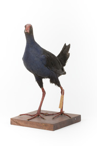 The Beechworth Burke Museum
Animal specimen - Australasian Swamphen, Trustees of the Australian Museum, 1860-1880
... . It primarily inhabits swamps, marshes, and other wet lowland areas.... It primarily inhabits swamps, marshes, and other wet lowland areas ...The Australasian swamphen is a visually striking and socially complex bird found across Oceania. It can be found in eastern Indonesia (specifically the Moluccas, Aru, and Kai Islands), Papua New Guinea, New Zealand, and Australia. As a member of the rail family (Rallidae), it belongs to the diverse order Gruiformes, which also includes cranes and other rail species. Like other rails, it possesses relatively short wings and a strong, elongated bill, both adaptations suited to its semi-aquatic wetland habitat. This swamphen is easily identified by its deep blue-purple plumage, prominent red frontal shield, and sturdy red legs. It primarily inhabits swamps, marshes, and other wet lowland areas, though its range has expanded to include pastures, roadsides, and farmland due to significant landscape modifications over the past 150 years. Unlike many wetland birds, it is highly adaptable and thrives in both natural and human-altered environments. Its diet is similarly flexible, consisting mostly of plant material such as grass stems, shoots, and leaves, but also including invertebrates and, on occasion, the young of other bird species. This specimen was misidentified as a Purple Swamphen in original catalogue records and is part of a collection of almost 200 animal specimens that were originally acquired as skins from various institutions across Australia, including the Australian Museum in Sydney and the National Museum of Victoria (known as Museums Victoria since 1983), as well as individuals such as amateur anthropologist Reynell Eveleigh Johns between 1860-1880. These skins were then mounted by members of the Burke Museum Committee and put-on display in the formal space of the Museum’s original exhibition hall where they continue to be on display. This display of taxidermy mounts initially served to instruct visitors to the Burke Museum of the natural world around them, today it serves as an insight into the collecting habits of the 19th century.This specimen is part of a significant and rare taxidermy mount collection in the Burke Museum. This collection is scientifically and culturally important for reminding us of how science continues to shape our understanding of the modern world. They demonstrate a capacity to hold evidence of how Australia’s fauna history existed in the past and are potentially important for future environmental research. This collection continues to be on display in the Museum and has become a key part to interpreting the collecting habits of the 19th century.This taxidermy specimen is of a Australasian swamphen which is mounted standing on a wooden platform and has a paper identification tag tied to its upper left leg. The specimen has dark colouring on its back and head with a purple-blue coloured neck, breast and belly. The bill is oversized and is orange/red which is the same colour as the frontal shield on the bird's face. The eyes are made from a red and black glass and the legs of this specimen are orange. The legs are elongated and the toes also long and unwebbed. 17e. / Purple Gallinule / Catalogue Page 35 / taxidermy mount, taxidermy, animalia, burke museum, beechworth, australian museum, skin, reynell eveleigh johns, bird, australian birds, swamphen, moorhen, purple bird, hen, purple swamphen, water bird -
 Flagstaff Hill Maritime Museum and Village
Document - Framed Poster, Borough of Warrnambool, Victoria, Australia, after 30/06/1875
... , financial worth, number of houses, connection with other areas... around 1875; its location, the area it covers, its population ...This document, also referred to as a word picture or Tablet, is framed in glass and timber with gilt trim, is handwritten with colour highlights. The penned letters rest on ruled guide lines, decorated where the lines intersect. The writing gives a description of the state of Borough of Warrnambool around 1875; its location, the area it covers, its population, Harbour and facilities, public buildings and institutions, imports and exports, financial worth, number of houses, connection with other areas of the Colony. A possible reason and origin for the document is found in an article ‘Link with US Exhibition’ from the Warrnambool Standard of December 19, 1981, written by local historian Bruce Morris. The writer mentions that the Warrnambool Borough Council met on 15th June 1875 and recorded a letter from G.C. Levey , secretary to the Melbourne group of commissioners representing the Colony, and Victoria in particular, for the Philadelphia Centennial Exhibition of 1876. The letter asks Council to provide “statistics as to the population, social condition and commercial and industrial state of the district in and around Warrnambool.” A sub committee was formed for the project. The Mayor, Cr. Thomas King, wrote and signed a Report, presented to the council on July 14, 1875, in which “The Committee … begs to recommend that a Tablet be prepared setting for the particulars respecting the following matters relating to the Borough”. The matters included area, population, annual income, churches, schools, other public buildings, societies and companies, general description of houses erected, and returns of exports and imports for 1874. The minutes note that the Report was adopted. The article above also notes the opinion of Warrnambool printers who have examined the document; it is almost certainly to be an old lithograph, which means there could be several copies. It is possible that there may be a copy in Melbourne and another in Philadelphia. It is interesting to note that (1) the quoted location co-ordinates are for an “Unnamed Road, Packsaddle NSW 2880, Australia”, and that the DMS co-ordinates for Warrnambool’s Council Offices differ, being 38.23.9.12 South, 142.28.52.887. (2) the date for “Exports and Imports for the Year Ending 30th June 1875” is different to the period mentioned by Cr. King in the sub committee’s Report of recommendation “returns of exports and imports for 1874”. The information required to have the figures for the end of June 1875 would need to have been compiled very quickly for the Tablet to be ready for the opening of the Philadelphia Exhibition on 10 May 1876. The document/certificate shows the following – - - - - - - - - - - - - - - -- - - - - - - - - - - - - - -- - - - - - - - - - - - - - -- - - - - - - - - - - - - - - “Victoria Australia, Borough of Warrnambool. Latitude, 30.24.50 South, Longitude 142.32 East The Principal Port in the Western District of the Colony and the Centre of its Choicest Agricultural Lands. Established a Municipality in 1855, and Created a Borough 1863. Population in 1875 4,500. Warrnambool is the nearest Port to Melbourne on the Western Seaboard, being about 160 miles distant. Coaches run to and from the Metropolis daily, in connexion [connection] with the Railway of Geelong and Steamers belonging to Local Companies sail between Melbourne, Warrnambool, Belfast [renamed Port Fairy], and Portland several times weekly. The Harbour is known as Lady Bay, and is partially protected by a reef of rocks stretching from the mouth of the Hopkins River. The formation of a Breakwater has been decided upon by the Government, to extend 600 yards, at an estimated cost of £100,000. There are two substantial Jetties, one of 800 and the other of 600 feet in length. The former is connected with the Town by means of a Tramroad, along which Goods, inwards & outwards, are conveyed, & the latter has been constructed solely for the purpose of facilitating the transit of material for the formation of the Breakwater. In addition to the trade of the Borough and District, the principal Townships up country receive their supplies from Melbourne and ship their exports through Warrnambool. Potatoes form the staple produce of the district, and the richness of the soil can be estimated by the fact that the Government Statistics for 1875 give as the average yield a return of Seven Tons to the acre. Several thousand acres between Warrnambool and Tower Hill are now being laid down in Potatoes by Tenants who have leased the lands at rates up to £5 per acre for the season 1875-6. Wool, Tallow, hides &c are also largely exported, while the shipments of all descriptions of Farm Produce are annually increasing. Area of Borough, 3362 Acres. Net Annual Value £27,000. Annual Revenue £5,500. Number of Houses in Borough 800. Public Buildings and Institutions Churches. Church of England, Roman Catholic, Presbyterian, Wesleyan, Congregational and Baptist. Schools. Three State Schools, average attendance nearly 1000. New Building in course of erection. Several private establishments. Banks. Bank of Australasia, Bank of Victoria, National Bank, Colonial Bank and Savings Bank. Public Buildings. Court house, Custom house, Post & Telegraph Offices, Survey & Land Offices, Shire £, Town Hall, Mechanics Institute, Volunteer Orderly Room, Odd Fellows Hall, Hospital & Benevolent Asylum, Temperance Hall &c. Companies & Societies. Steam Navigation Co, Woolen Mill Co, Gas Co, Racing Club, Amateur Turf Club, Agricultural Society, Farmers’ Club, Cricket Club, Anglers’ Society, Building Society, Freemasons Odd Fellows, Foresters, Druids, Hibernians. Protestant Alliance, Rechabites, Sons of Temperance, &c, Fire Brigade &c. --- Exports and Imports for the Year Ending 30th June 1875 –-- --Exports Total Tonnage 27,800 (Calculated at the Current Warrnambool Market Prices) Potatoes Wool Wheat Barley Hides Skins Fowls Butter Cheese Eggs Tallow Leather Ale Pigs Sheep Sundries --Imports 13,000 Tons Of the Estimated Value of £520,000 Total Tonnage of Exports and Imports 40m900 Tons, Value £806,627 Passenger Travels, to ad from Warrnambool during year, 10,000 persons Revenue from all sources paid through Warrnambool Sub Treasury From 1860 to June 1875 £1, 292, 300 Thomas King [signed] Mayor Henry T Read [signed] Town Clerk” - - - - - - - - - - - - - - -- - - - - - - - - - - - - - -- - - - - - - - - - - - - - -- - - - - - - - - - - - - - - The document is of historical, social, economic and local significance in that it summarises activities, business, community, trade, travel and government at a point in time in Warrnambool’s history – 30th June 1875.Document, also referred to as a ‘word picture’ or ‘tablet’. Document is framed in glass and timber with gilt trim, handwritten with colour highlights. The penned letters rest on ruled guide lines, decorated where the lines intersect. Document outlines the establishment of Warrnambool as a Municipality in 1855 and Borough in 1863, with a population of 4,500 in 1875. It states geographic location, public buildings and institutions, harbor facilities and imports and exports for the year ending 30th June 1875. Two signatures "Thomas King" Mayor and "Henry T Read" Town Clerk. It shows the Coat of Arms of the Borough of Warrnambool.Signatures - "Thomas King" Mayor and "Henry T Read" Town Clerk. Warrnambool Coat of Arms; “British Coat of Arms, above sailing vessel and sheaf of wheat in sun, motto “By these we flourish” and around circumference “Borough of Warrnambool 1855”flagstaff hill, warrnambool, shipwrecked coast, flagstaff hill maritime museum, maritime museum, shipwreck coast, flagstaff hill maritime village, great ocean road, borough of warrnambool, municipality of warrnambool, document borough of warrnambool 1875, word picture of warrnambool 1875, tablet of borough of warrnambool 1875, statistics borough of warrnambool 1875, lithograph borough of warrnambool 1875, coat of arms warrnambool, warrnambool city motto – in these we flourish, establishment of warrnambool, warrnambool history, thomas king mayor of warrnambool, henry t read town clerk of warrnambool, warrnambool breakwater, warrnambool jetty, warrnambool imports and exports 1875, warrnambool agriculture 1875, warrnambool business 1875, warrnambool population 1875, centennial exhibition philadelphia 1876, framed certificate -
 Kew Historical Society Inc
Plan, Melbourne & Metropolitan Board of Works : Borough of Kew : Detail Plan No.1571, 1904
... in the area. The other version of the plan identifies the buildings... in the area. The other version of the plan identifies the buildings ...The Melbourne and Metropolitan Board of Works (MMBW) plans were produced from the 1890s to the 1950s. They were crucial to the design and development of Melbourne's sewerage and drainage system. The plans, at a scale of 40 feet to 1 inch (1:480), provide a detailed historical record of Melbourne streetscapes and environmental features. Each plan covers one or two street blocks (roughly six streets), showing details of buildings, including garden layouts and ownership boundaries, and features such as laneways, drains, bridges, parks, municipal boundaries and other prominent landmarks as they existed at the time each plan was produced. (Source: State Library of Victoria)This plan forms part of a large group of MMBW plans and maps that was donated to the Society by the Mr Poulter, City Engineer of the City of Kew in 1989. Within this collection, thirty-five hand-coloured plans, backed with linen, are of statewide significance as they include annotations that provide details of construction materials used in buildings in the first decade of the 20th century as well as additional information about land ownership and usage. The copies in the Public Record Office Victoria and the State Library of Victoria are monochrome versions which do not denote building materials so that the maps in this collection are invaluable and unique tools for researchers and heritage consultants. A number of the plans are not held in the collection of the State Library of Victoria so they have the additional attribute of rarity.Digital copy of the original survey plan, issued by the MMBW to a contractor with responsibility for constructing sewers in the area identified on the plan within the Borough of Kew. The plan was at some stage hand-coloured, possibly by the contractor, but more likely by officers working in the Engineering Department of the Borough and later Town, then City of Kew. The hand-coloured sections of buildings on the plan were used to denote masonry or brick constructions (pink), weatherboard constructions (yellow), and public buildings (grey). This plan is part of a large and historically significant group of MMBW plans and maps that was donated to the Society by the Mr Poulter, City Engineer of the City of Kew in 1989. When the contracts were let for surveyors to identify and record the extant houses and landscapes within an area for the Board of Works, the contracts were let at separate times, hence the anomaly where two copies of Plan No.1571 exist in our collection. The first of these plans identifies the building materials used in houses bordering Fitzwilliam Street, Edgevale Road, May Street, Malin Street, Davis Street and Wellington Street. The cut off point for the survey was the south side of Wellington Street. By 1903 when the survey was undertaken many of the sites were already built on, particularly those facing Edgevale Road. The plan identifies the preponderance of weatherboard houses in the area. The other version of the plan identifies the buildings between Wellington Street and Cotham Road.melbourne and metropolitan board of works, detail plans, mmbw 1571, cartography -
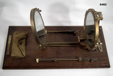 Bendigo Military Museum
Instrument - Heliograph Mk V Training Aid - circa 1912, 1912
... useful in remote areas where other forms of communication were... useful in remote areas where other forms of communication were ...The Heliograph MkV is a fascinating piece of historical surveying and communications equipment. It was primarily used for visual signaling by reflecting sunlight with a mirror to send coded messages over long distances. This method was primarily useful in remote areas where other forms of communication were not available. The MkV model, specifically, was widely used by the British Army and other military forces from around 1906 until the mid 1960s. It remained in use with the Australian Army Survey Corps until the mid 1980s. The device typically included a 5 - inch mirror and was often mounted on a tripod for stability. Initially the instrument was used to communicate between survey stations using Morse code to coordinate their activities. Later when better forms of communication were available they were used for precise angle alignment where the sunlight reflection from the mirror was targeted between the survey stations to give very accurate results. The MkV was relatively light weight and portable, making it ideal for use in the field. It could be setup and adjusted quickly. The heliograph had an adjustable mirror that could be tilted to reflect sunlight towards a distant receiver. Surveyors could align the mirror using a sighting device. Whilst it was primarily used by the Military it was also used in civil surveying particularly in the remote areas of Australia. This instrument was used as a training aid to help teach surveyors at the Royal Australian Survey Corps School of Military Survey. Catalog item No 2009 is a tripod that was used to mount the Heliograph whilst being used for surveying.A Heliograph containing two mirrors with brass surrounds mounted on a wooden board as a Training Aid. Item has additional parts attached to the base board."Heliograph Mk V Training Aid"royal australian survey corps, rasvy, fortuna, army survey regiment, army svy regt, asr