Showing 166 items matching "property sales"
-
 National Wool Museum
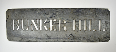
Stencil - BUNKER HILL
This stencil was used as a property name for the transportation of wool bales. All wool bales stamped with BUNKER HILL would have transported from or to Bunker Hill.Wool bale export stencil - BUNKER HILLBUNKER HILLwool transportation, wool sales, wool export -
 National Wool Museum
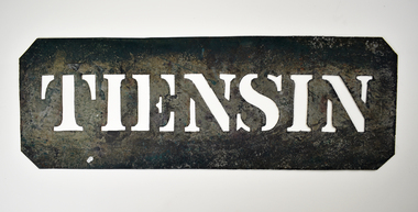
Stencil - TIENSIN
This stencil was used as a property name for the transportation of wool bales. All wool bales stamped with TIENSIN would have transported from or to Tiensin.Wool bale export stencil - TIENSINTIENSINwool transportation, wool export, wool sales -
 National Wool Museum
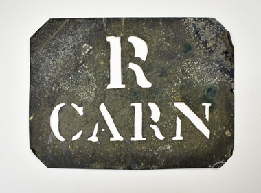
Stencil - R CARN
This stencil was used as a property name for the transportation of wool bales.Wool bale export stencil - R CARNR CARNwool sales, wool transport, wool export -
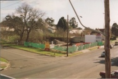
 Kilmore Historical Society
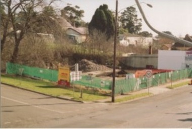
Photograph, Mobil Garage, 2006
Previously Mobil Garage owned by Danny and Pat D'Elia until 2001. Then demolished in 2006.15cm x 10cm colour photograph of the corner of Lancefield Road and Sydney Street. Printed on matte photographic paper (Kodak brand) Recent demolished building with rubble piled up and green security fencing around the perimeter of the property. Sign for the Willowmavin Estate is visible advertising land sales. Multiple photographs with multiple views available.Printed on back: Development information: Premier service station, construction sites -
 Kilmore Historical Society
Photograph, Mobil Garage, 2007
Previously Mobil Garage owned by Danny and Pat D'Elia until 2001. Then demolished in 2006.15cm x 10cm colour photograph of the corner of Lancefield Road and Sydney Street. Printed on matte photographic paper (Kodak brand) Recent demolished building with rubble piled up and green security fencing around the perimeter of the property. Sign for the Willowmavin Estate is visible advertising land sales. Multiple photographs with multiple views available.Printed on the back: Development information: PREMIER service stations, construction sites -
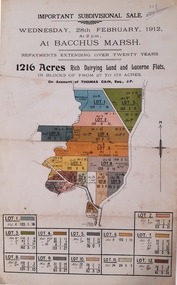 Bacchus Marsh & District Historical Society
Map, Important Subdivisional Sale at Bacchus Marsh, Wednesday 28 February, 1912, 1912
In the later 19th century and early 20th centuries Thomas Cain was a major farmer in the Bacchus Marsh district and a significant participant in community life and affairs. The sale of some of his most significant properties towards the end of his life generated wide interest in Bacchus Marsh and beyond.Paper. 33cm x 21cmnon-fictionIn the later 19th century and early 20th centuries Thomas Cain was a major farmer in the Bacchus Marsh district and a significant participant in community life and affairs. The sale of some of his most significant properties towards the end of his life generated wide interest in Bacchus Marsh and beyond.land sales, thomas cain, landholders -
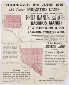 Bacchus Marsh & District Historical Society
Map - Land Sales Plan, Broadlands Estate, Bacchus Marsh, 1916
This land sales map was produced by real estate agents for an auction of part of a property near Bacchus Marsh known as the Broadlands Estate. 132 acres of irrigated land in 11 separate lots was to be auctioned on the 8th of June 1916. On the 27 May 1916, nine of the 11 eleven lots were withdrawn from sale. The reason stated was due to "road and severance difficulties", according to a notice in the Bacchus Marsh Express newspaper on 27 May, 1916, page.2. When the sale took place on 8th June the two lots were passed in but the local newspaper reported they were expected to be sold privately, see Express, 17 June, 1916, page. 2. The Broadlands Estate was owned by the Miller family whose father Henry Miller, 1809-1888, was a politician and an immensely wealthy financier in Victoria.A typical example of a land sale map of this era. The Broadlands Estate was just over 2,000 acres at its its peak size and was a significant holding of land in the Bacchus Marsh district. Paper printed land sales mapbroadlands estate bacchus marsh, land sales bacchus marsh, farms bacchus marsh, henry miller 1809-1888 -
 Bacchus Marsh & District Historical Society
Map, Bacchus Marsh Township and Nearby Districts Maps Volume
This volume of maps is believed to have been compiled by staff at the Shire of Bacchus Marsh and was presumably used to inform and assist Shire staff and Councillors in the carriage of their duties.This collection of maps are significant due to their rarity as many of them are unique maps made for local purposes in the Bacchus Marsh region. They are also of strong research value containing a wide variety of information including landholders, land sales, infrastructure, such as roads, bridges, public, commercial and private buildings, houses, land use, and geographic features over multiple decades from the late nineteen century into the middle part of the twentieth century.One bound volume of maps comprising cadastral maps, (indicating property owners and land boundaries), land plans and real estate auction plans and advertising material, and other maps indicating major infrastructure like proposed roads and irrigation areas. Most of the maps and plans are of Bacchus Marsh and nearby areas but some maps are of nearby towns such as Melton, Ballan and Blackwood. The volume comprises 52 pages. Most pages have a single map or plan pasted onto it but some contain 2 or 3 different maps. There are 81 maps in total. Map 1 Liquidators Sale 1896. Map 2. Woodside Estate Sale 1913. maps, maps bacchus marsh, maps bacchus marsh region -
 Wodonga & District Historical Society Inc
Photograph - Codling Collection 01 - Wodonga, High Street West - Holloways Motors, John Henderson & Associates, M & H Electrics, Kwik Stitch, T.A.B, 1980s
... Fabrics and T.A.B. Holloways Motors property has now been... Sales and Service, Sargeants Property Conveyancing ...Miss Olive Codling was a Foundation Member and a Life Member of the Wodonga Historical Society. Many of her prize-winning photos are held in the Society Collection. She also held a range of roles and committee positions in a wide range of Wodonga community organisations. These included the Horticultural Society, the Wodonga Arts Council, the Wodonga Camera Club and the Wodonga Lapidary Club. This photo collection is significant as it documents how the businesses and buildings in Wodonga have evolved and contributed to community throughout the 20th century.Wodonga, High Street West Businesses including Holloways Motors, John Henderson & Associates, M & H Electrics, Kwik Stitch Fabrics and T.A.B. Holloways Motors property has now been incorporate Prd into Junction Place. In 2021 the other premises are occupied by J & M Clothing, Elna Sales and Service, Sargeants Property Conveyancing and a Chiropractic centre.wodonga businesses, high st wodonga, holloways motors, john henderson & associates -
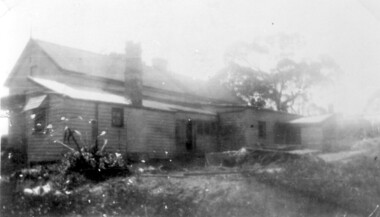
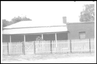 Wodonga & District Historical Society Inc
Photograph - Old Barnawartha Homestead
Henry Richardson came from England in 1852 and this was his home from 1871 to 1888. His son Henry, better known as Harry, managed the property from 1888 until his death in 1926. The property was sold in 1932 and has been known as Old Barnawartha for over 140 years. The homestead exhibited no particular style, it looked like a Cornish Miner’s cottage, and appeared as if pieces were added on as the need arose. The property is well known for topping both sheep and cattle sales at Newmarket.This item is significant because it depicts the home of an early Wodonga District pioneerA black and white image of an old homestead. There is a white picket fence across the front of the building.old barnawartha, early settlement, wodonga and district -
 City of Kingston
Pamphlet - Colour, Stillwell and Co, The Hill Estate Highett Great Subdivisional Auction Sale, 1917
Sales plan for land in the suburb of Highett, bounded by Point Nepean Road and incorporating Sandford Street, Turner Road, Alfred Street, Peace Street and Tennyson Street. .The developing urban area of Highett within the City of Kingston. This land sale pamphlet illustrates the subdivision of land within the municipality and the changing demographic of the district as new houses are constructed.Colour pamphlet advertising subdivisional auction sale of the Hill Estate Highett. Incorporates a map of the estate bordered by Point Nepean Road and encompassing Sandford Street, Turner Road, Alfred Street, Peace Street and Tennyson St. Handwritten in grey pencil on reverse: Hill Street / Jamieson Handwritten in blue pencil on reverse: The Hill Estate Handwritten in blue pencil on subdivision map: [tick] [on majority of properties marked on map]highett, land sales, estate -
 City of Kingston
Pamphlet - Colour, H. R. Hill & Co, Walker's Estate, Cheltenham for sale by public auction, c. 1923
Sales plan for land in the suburb of Cheltenham, encompassing both sides of Walker Grove, a section of Centre Dandenong Rd and Axelton St. The developing urban area of Cheltenham within the City of Kingston. This land sale pamphlet illustrates the subdivision of land within the municipality and the changing demographic of the district as new houses are constructed.Black and white pamphlet advertising for private sale the Station Entrance Estate, Highett. Incorporates a map of the estate bordered by Wickham Road, Railway Parade, Highett Road and Point Nepean Road.Handwritten in black pen on subdivision map: 'x' written on subdivisions 2, 3, 8-11, 15-17, 19. Potentially indicating that these properties did not sell at auction. Handwritten in black pen on subdivision map: assumed sale price on subdivisions 1, 4-7, 12-14, 18, 20-31. land sales, cheltenham, estate -
 City of Kingston
Pamphlet - Colour, Duffus Bros, Railway Reserve Highett, c. 1923
Sales plan for land in the suburb of Highett, titled Railway Reserve, incorporating properties along Wolseley Street, Livingston Street, Highett Road and Worthing Road. The developing urban area of Highett within the City of Kingston. This land sale pamphlet illustrates the subdivision of land within the municipality and the changing demographic of the district as new houses and shops are constructed close to infrastructure.Colour pamphlet advertising thirty eight shop and villa sites for sale at the Railway Reserve, Highett. Incorporates a map of the reserve with properties available on Wolseley Street, Livingston Street, Highett Road and Worthing Road. Handwritten in grey pencil: assumed sale price recorded on subdivisions 1-7, 10, 22, 23 and 34 Handwritten in grey pencil on subdivision 4: C. Nevill / City of Melbourne bank Handwritten in grey pencil across subdivision 7: 49' Handwritten in grey pencil across subdivision 21 and 22: 134' Handwritten in grey pencil across subdivision 25 and 26: 200' Handwritten in grey pencil across subdivision 36 and 37 and both top and bottom: 120' Hand drawn in blue pencil: outline of subdivision 4 Hand drawn in blue pencil: outline of subdivisions 7, 23, 28, 37, 38 along left hand side, subdivisions 38, 37 and 36 on Wolseley Street, subdivisions 30 and 29 along Wolseley Street, subdivisions 29 and 24 along the middle of the plan, subdivisions 24 and half of 25 along Livingston Street, half of subdivision 20 along the middle of the plan, subdivisions 21 and 22 along the Right of Way between Livingston Street and Highett Road, and along the right hand border of subdivision 7. Handwritten in ink adjacent to the subdivision plan, updside down, in the bottom right hand corner: 276 / 54 / 280 / 45 / 320 / 202 / 200 / 134 / horizontal line / 11/14 Handwritten in ink adjacent to the subdivision plan, updside down, in the bottom right hand corner: 1714)2200(15 / 1714 / horizontal line / 486land sales, highett -
 Eltham District Historical Society Inc
Folder, Landscape, 60 Lavender Park Road, Eltham South
Morrison Kleeman Real Estate sales information material relating to the property "Landscape". Built by the cartoonist and painter Percy Leason (1889-1959). anthropologist. Leason was associated with the Montsalvat Artists’ Colony and built “Landscape” before he moved to the USA in 1937 . 6 documents, 12 pages A4 gayle blackwood collection, houses, morrison kleeman real estate, eltham south, landscape, lavender park road, percy leason -
 Surrey Hills Historical Society Collection
Photograph, 6a Thistle Street, Surrey Hills, 1924
One of the oldest homes in Surrey Hills. The photo was taken in 1924 when the property was purchased by Mr John Francis Evans, father of Mrs Lillian Austin. The Evans family came from Gembrook. John Evans was born in Wales; he and his wife Mary had 3 children, 2 daughters and one son. Mary Evans pre-deceased her husband, who died on 23 October 1924 at Hillsborough, 6A Thistle Street. The first owner of the property was Mrs Rachel Sweetnam (nee Lewis) who married Thomas Edward Sweetnam on 24 September 1884 at St John's Church, Camberwell. REF: THE ARGUS 4 Oct 1884 Thomas second eldest surviving son of Matthew Sweetnam married to Rachel (Ray) third eldest daughter of Captain T.D. Lewis, Culm Haven, Camberwell. Thomas was active in land sales and variously described as a land agent, real estate agent and auctioneer. The property - Hillsboro or Hillsborough - was originally a house on a farm of 10 acres owned by her. It became 6A Thistle Street. According to the Alan Holt property register Rachel Sweetnam owned the property prior to 1890 and a family tree on Ancestry.com has that it was owned by her in c1886. It is likely that at this stage the property was an investment rather than the Sweetnam's family residence. Other property owners or residents are: 1890 Selina Gaylor 1900 Stephen Pullen 1910 William Murray (draftsman) 1920 George C Hughes 1930 Arthur Leslie Austin (tram driver) 1980 Mrs Lillian Evelyn Austin Lillian Austin died on 19 August 1983 and the property was sold that year for $87,000. The house is still extant (January 2025). Note that we also have material / photos regarding George Hughes and family.Black and white photo of a timber home with brick chimneys and a (?) corrugated iron roof. There are sheds and outbuildings attached to the house. The garden looks untended. In the background a mature eucalypt tree can be seen.houses, hillsboro, timber houses, mrs lillian austin, hillsborough, selina gaylor, stephen pullen, william murray, george hughes, arthur austin, john francis evans, thistle street -
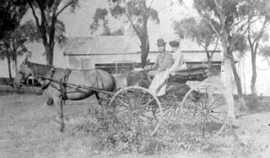 Surrey Hills Historical Society Collection
Photograph, 'Hillsboro' or "Hillsborough' - 6a Thistle Street, Surrey Hills, pre-1890
The photo was found behind a mantelpiece in the house at 6A Thistle Street while it was being renovated. It is thought to be of the first owner, Mrs Rachel Sweetnam (nee Lewis) and her husband, Thomas Edward Sweetnam. They were married on 24 September 1884 at St John's Church, Camberwell. REF: THE ARGUS 4 Oct 1884 Thomas second eldest surviving son of Matthew Sweetnam married to Rachel (Ray) third eldest daughter of Captain T.D. Lewis, Culm Haven, Camberwell. Thomas was active in land sales and variously described as a land agent, real estate agent and auctioneer. The property - Hillsboro or Hillsborough - was originally a house on a farm of 10 acres owned by her. It became 6A Thistle Street. According to the Alan Holt property register Rachel Sweetnam owned the property prior to 1890 and a family tree on Ancestry.com has that it was owned by her in c1886. It is likely that it was an investment rather than a family residence. Thomas Sweetnam was President of the Boroondara Shire 1888/89 and a councillor from 1886-1891. During his time as Shire councillor in 1887 he was charged with assaulting Charles A. Chandler, a window blind manufacturer, in response to an ‘insulting note’ left at Sweetnam’s house. Sweetnam was fined two guineas and 31 shillings. Sweetnam was also President of the Camberwell Gun Club from around 1890 – 91. In 1893 he relocated to Ferntree Gully, where he contested for the municipality’s North Riding council seat. Multiple references can be found on Trove. Note that the gentleman in this photo does bear a resemblance to Thomas Sweetman, President of Boroondara Shire in 1888-1889 found in the City of Boroondara Library Service mayoral portrait collection. No known photo of Rachel Sweetnam. Other property owners or residents are: 1890 Selina Gaylor 1900 Stephen Pullen 1910 William Murray (draftsman) 1920 George C Hughes 1930 Arthur Leslie Austin (tram driver) 1980 Mrs Lillian Evelyn Austin Sold in 1983 for $87,000. The house is still extant (January 2025). Note that we also have material / photos regarding George Hughes and family.This photo is one of the earliest photos of residences of Surrey Hills.Black and white photo of a woman and man in a buggy behind which is a simple house with a verandah at one end, surrounded by eucalypt trees.hillsboro, house names, thistle street, horse-drawn vehicle, clothing and dress, hillsborough, rachel sweetnam, rachel lewis, thomas sweetnam, selina gaylor, stephen pullen, william murray, george hughes, arthur austin, lillian austin -
 Bacchus Marsh & District Historical Society
Map, Plan of Land at Bacchus Marsh, the Property of James Young, 1868
James Young was a prominent businessman, land owner and public figure in the early colonial period of Bacchus Marsh. In February 1868 he offered for sale through the agent W. Anderson 38 blocks of land which ran from the Lerderderg RIver westwards beyond Gisborne Road in the vicinity of the present day Masons Land. The land for sale was described as, 'unsurpassed Agricultural Land, in the immediate vicinity of Bacchus Marsh, varying in size from 2 to 12 acres each'. The sale notice in the Bacchus Marsh Express of 1st February 1868 page 2, also noted that, ' Plans can be seen at Mr. Young's Border Mills Store, and at the Border Inn'. One of the largest and most important land sales in the early colonial period of Bacchus Marsh.A single page paper map showing 38 blocks of land for sale in 1868 in the vicinity of Masons Lane Bacchus Marsh. Scale 11 chains to 1 inch. The map is pasted into a bound volume containing 76 maps or plans in total. High resolution digital image stored on BMDHS computer network. land sales bacchus marsh, bacchus marsh victoria maps, james young 1816-1871, masons lane bacchus marsh land sales -
![Map, Liquidator's sale, 1896. [Woolpack Estate, Bacchus Marsh]](/media/collectors/5e461d8021ea67224c82f2a1/items/6779ee97032b72846b5995f2/item-media/6779ef33032b72846b599b30/item-fit-380x285.jpg) Bacchus Marsh & District Historical Society
Bacchus Marsh & District Historical SocietyMap, Liquidator's sale, 1896. [Woolpack Estate, Bacchus Marsh]
The Woolpack Estate was an area of land owned by various landowners in the Bacchus Marsh area since the early Colonial period of the 1840s. The area was located on the eastern side of the Bacchus Marsh township about 7 kilometers from the town. The Lerderderg River ran through part of the land and so did the Melbourne to Ballarat Road. The historic Woolpack Inn associated with James Crook was also located on this land. By 1896 150 acres of this land was under the control of liquidators for the Federal Bank of Australasia who instructed that the land be sub-divided and sold in lots by public auction. A successful sale was held on 24 June 1896. Most of the blocks of land were sold for higher than expected prices and most of the buyers were people from the town and district of Bacchus Marsh. The map includes various details about the land which is described on the map as an "important sale of rich alluvial irrigable flat land in the Bacchus Marsh Valley, and other properties". The auction was conducted by the local agents W. Anderson and Bence in conjunction with Pearce Brothers also of Bacchus Marsh.A single page paper map showing a plan of 150 acres of land from the Woolpack Estate to be sold in various lots in June 1896. Also shown on the map are lots for sale at Robinson's Farm on Coimadai Creek and allotments near Bacchus Marsh railway station, including lots on Government Road (East Maddingley Road), View Street and Government Road (Parwan Road). No scale provided. The map is pasted into a bound volume containing 76 maps or plans in total. High resolution digital image stored on BMDHS computer network. land sales bacchus marsh, bacchus marsh victoria maps, woolpack estate bacchus marsh victoria -
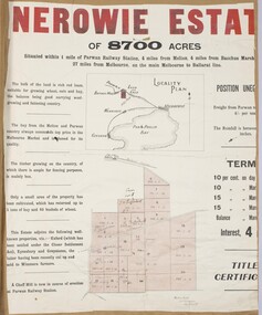 Bacchus Marsh & District Historical Society
Map, Nerowie Estate Land Sale 1910
The Nerowie Estate was a large rural property of 8,700 acres (3520 hectares) near the locality of Parwan only a few kilometers east of Bacchus Marsh. It had once formed a large part of the land owned by the pioneering Staughton family.A single page paper map showing the land offered for sale from the Nerowie Estate at Parwan near Bacchus Marsh in 1910. The map is pasted into a bound volume containing 76 maps or plans in total. High resolution digital image stored on BMDHS computer network. nerowie estate parwan, land sales parwan, land sales bacchus marsh, staughton family bacchus marsh -
 Bacchus Marsh & District Historical Society
Map, Subdivision of the Manor House Property Bacchus Marsh c.1908
This land sales plan shows allotments of land offered for sale in the inner township area of Bacchus Marsh in 1908. The land put up for sale was from the estate of the late Mr and Mrs J.E. Crook. That being James Elijah Crook and his wife Harriet, (nee Athorn). The Crooks had been resident in Bacchus Marsh since the 1840s and were prominent members of the community. They were prominent in the business, social and civic affairs of the town and district. In the 1850s the Crooks acquired the Manor House and nearby land once owned by the Bacchus family. James Crook died in 1889. When Harriet Crook died in February 1908 their estate was offered for sale. This included the large stone home known as the Manor House and various parcels of land including around 50 allotments of land near the Manor House, bounded by Young, Lerderderg, Crook and Main Streets. Most of these allotments of land were sold in October 1908. The Manor House itself was passed in at the sale and continued to be owned by the Crook family for several decades after 1908.A single page map on a single page of a bound volume of maps. The map shows portions of land for sale from the subdivision of the Manor House property in Bacchus Marsh in 1908. The names of most of the buyers of the portions of land have been hand-written into the various allotments they purchased. The maps are pasted into a bound volume containing 76 maps or plans in total. High resolution digital image stored on BMDHS computer network. bacchus marsh victoria maps, land sales bacchus marsh, manor house bacchus marsh, crook family bacchus marsh -
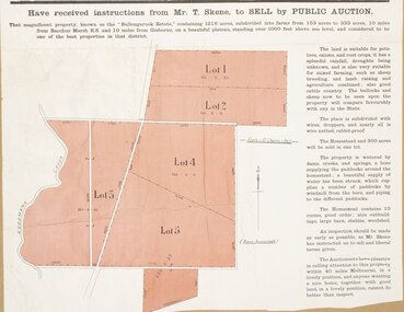 Bacchus Marsh & District Historical Society
Map, Bullengarook Estate Property Sale. 1911
Bullengarook is a locality located 19 kilometers north of Bacchus Marsh. Pastoral leases for European colonists were granted to people for this area from around the 1840s.The Bullengarook Estate was part of these early pastoral holdings. By the 1900s the property had been owned by the Skene family for a number of years. In early 1911 the property then consisting of 300 acres and the homestead upon it was offered for sale in one lot. It appears however that the sale of the property did not go through in 1911. It was later leased by Thomas Skene to a Mr Coutts in 1915 and ultimately and at a later stage the property was sold by the Skene family.A single page paper map showing land allotments for sale from the Bullengarook Estate. The map is pasted into a bound volume containing 76 maps or plans in total. High resolution digital image stored on BMDHS computer network. land sales bacchus marsh, bullengarook land sales, bullengarook estate, bullengarook vic history -
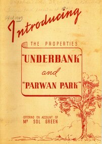 Bacchus Marsh & District Historical Society
Booklet, Introducing the Properties Underbank and Parwan Park offering on account of Mr Sol Green
Solomon (Sol) Green was a major bookmaker, businessman, real estate investor, racehorse owner and trainer, and philanthropist. His connection to Bacchus Marsh was through his ownership of the Underbank Stud property which he purchased in 1924. He also owned the Parwan Park property for some time. Both of these properties were put up for sale in 1947 just a year before the death of Sol Green in 1948.Stapled printed softcover booklet. 20 pages. 200mm x 290mm. Facsimile reproduction of a real estate booklet originally produced in 1947 by Sands and McDougall Pty Ltd for sale of the Underbank and Parwan Park properties in Bacchus Marsh. Facsimile reprint of original publication. Date of reprint copy c.2022. Original copy, printed 1947, is also held by Bacchus Marsh and District Historical Society. BMDHS Location: AR/SU4non-fictionSolomon (Sol) Green was a major bookmaker, businessman, real estate investor, racehorse owner and trainer, and philanthropist. His connection to Bacchus Marsh was through his ownership of the Underbank Stud property which he purchased in 1924. He also owned the Parwan Park property for some time. Both of these properties were put up for sale in 1947 just a year before the death of Sol Green in 1948. solomon green 1868-1948, bookmakers, parwan park, underbank stud, land sales bacchus marsh -
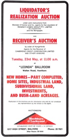 Ringwood and District Historical Society
Pamphlet, Liquidator's and Receiver's Auction, Highland Boulevard, Ringwood, Victoria, and other locations - Circa 1980
Multi-fold brochure with Order of Sale list of home sites, industrial land, subdivisional land and bushland acreages being auctioned at "Leonda" Ballroom, Hawthorn, Vic., Tuesday 23rd May (year not documented, circa 1980). Brochure includes 8 homesites with handwritten sales notations for Lots 94, 99, 100, 102, 104 and 105 Highland Boulevard, Ringwood at 11.30a.m., and at 11.45a.m., 3 completed homes at Lots 86, 88 and 89 & 5 near-completed homes Lots 74, 75, 76, 77 and 79 Highland Boulevard. Auctioneers - Blackburn & Lockwood Pty Ltd., 1017 High Street, Malvern, Phone 207821 After Hours 20 4444.Liquidator's Realization Auction under joint instructions from Brendan O'Connor and Co., agents for the Liquidator of Regency Homes Group Pty. Limited (in Liquidation) and the Mortgagee. Receiver's Auction by order of Hungerfords, Agents for the Receiver of Cambridge Credit Corporation Limited and other vendors. Order of Sale property locations include Mulgrave, Ringwood, Doncaster, Portartlington, Geelong, Altona, Mooroolbark, Scoresby, Gembrook, Maidstone, Port Melbourne, Laverton, Werribee, Werribee North, and Sunshine. -
 Eltham District Historical Society Inc
Photograph - Digital Photograph, Marguerite Marshall, Gordon Ford's Garden, 'Fulling', Pitt Street, Eltham, 10 November 2006
'Fulling', the half-hectare property at Pitt Street, Eltham was the home of landscape designer Gordon Ford and his wife Gwen. Ford bought the property in 1948, originally part of an orchard. The garden encapsulates the major trends of Australian garden design in the second half of the 20th century. The garden design is based on mass (plants) and void (paths and pools), textures and forms. It epitomises the Eltham style because of its relaxed informality and attraction to native wildlife. The mud brick house and designed and built by Ford commenced in 1948. Several extensions were added up to 1970 and were built by Graham Rose (Source: information panel for exhibition, n.d.) Covered under Heritage Overlay, Nillumbik Planning Scheme. Published: Nillumbik Now and Then / Marguerite Marshall 2008; photographs Alan King with Marguerite Marshall.; p147 A narrow timber gate opens onto a garden that has had a huge impact on natural garden development in Australia since the 1950s.1 Fulling, the half-hectare property at Pitt St, Eltham, was the home of the landscape designer, Gordon Ford, who died in 1999. The garden ‘encapsulates the major trends of Australian garden design in the second half of the 20th century...and epitomises the Eltham style of garden’.2 It in turn, was influenced by several Victorian major landscape designers of the mid 20th century – Ellis Stones, Peter Glass and Edna Walling. The gate opens onto a sandy gravel path, one of several, which wind around dramatic pools and what appear to be natural bush, but on close inspection are carefully integrated native, indigenous and exotic plantings. Retaining walls and steps of rock through the garden link different terrace levels. Lichen-covered boulders serve as steps across a pool, leading to the triple level mud-brick house. Ford bought the property, which was originally part of an orchard, in 1948. As the son of a Presbyterian minister, Ford received a good education, which included learning Latin. This was advantageous when he worked in plant sales for the Forestry Commission, before the Second World War. In the late 1940s, however, Ford turned to building and landscape gardening. He worked on the Busst house, an early mud-brick building designed by Alistair Knox and at the same time, Ford was employed by Ellis Stones. Knox described Ford as, ‘one of the funniest men of the district. ...Rocky’s (Ellis Stones) Depression stories and Gordon’s memory and quick tongue made the jobs the most enjoyable of all those hysterical times that made Eltham the centre of the eternal laugh, between the years of 1945 and 1950’.3 Ford’s house, like so many after the war, was built progressively, as more space was needed and formerly scarce materials became available. It began with an army-shed of timber-lined walls, now used as the kitchen. Ford then built what is now the lounge room, and the house grew ‘like topsy and on a shoestring,’ says his widow Gwen. A lot of second-hand materials such as window frames were used, a style made famous particularly with their extensive use at Montsalvat, the Eltham Artists’ Colony. The house was constructed as a joint venture with friends, including artist Clifton Pugh, who built Ford’s bedroom for £10. The polished floorboards and solomite (compressed straw) ceilings, interspersed with heavy beams, exude warmth. The result is a home of snug spaces, with soft light and garden vistas. Several other mud-brick buildings were constructed as needed, including a studio and units for bed-and-breakfast clients. The garden, which has been part of the Open Garden Scheme since the mid 1980s, is based on a balance of mass (plants) and void (paths and pools), textures and forms. It epitomises the Eltham style because of its relaxed informal ethos and attracts native animals. Wattlebirds, scrub wrens, pardalotes, currawongs, owls and even kangaroos, have been seen at Fulling. Gwen, a former English teacher who has worked on the garden since around 1970, urged and helped Ford write his book, The Natural Australian Garden.4 Several of Ford’s favourite trees are in the garden, including the native Casuarina or She-Oak. In spring, the garden is dusted with the purple Orthrosanthus multiflorus or blue native irises and rings with the calls of birds attracted to plants like the callistemons, correas and grevilleas.This collection of almost 130 photos about places and people within the Shire of Nillumbik, an urban and rural municipality in Melbourne's north, contributes to an understanding of the history of the Shire. Published in 2008 immediately prior to the Black Saturday bushfires of February 7, 2009, it documents sites that were impacted, and in some cases destroyed by the fires. It includes photographs taken especially for the publication, creating a unique time capsule representing the Shire in the early 21st century. It remains the most recent comprehenesive publication devoted to the Shire's history connecting local residents to the past. nillumbik now and then (marshall-king) collection, eltham, fulling, gordon ford garden, pitt street, eltham mud brick buildings, mud brick house -
 Merbein District Historical Society
Document, Business Records - Horticultural property, 1933-1939
household expenditure, mckay family, dried fruit sales, block wages, block purchases, block repairs and depreciation, block 29a birdwoodton, horticulture -
 Melbourne Tram Museum
Document - Report, David Frost, Sale of 33 Fifth St Black Rock - tram shed
Documents related to the sale of 33 Fifth Street Black Rock, including two colour photocopies with the external and internal views of a shed said to be a former tram shed associated with the Sandringham to Black Rock horse tram line. Includes the City of Bayside heritage report and Hocking Stuart sales sheets for an auction on Saturday 4 August 2007. It would appear from Google Earth that all buildings were demolished.Yields information about the sale of a property said to be associated with the Black Rock tramway.Four A4 sheets - two colour and one colour sheet providing auction details.trams, railways, vr trams, sandringham, black rock tramway, sale of land, 33 fifth st black rock -
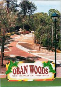 Ringwood and District Historical Society
Document - Land Sale Folder, Oban Woods Subdivision, Ringwood North, Vic., - circa 1997
Folder containing multi-fold colour pamphlet advertising Lots 6 to 12 of Oban Woods Estate with location map and summary of subdivision features. A4 size attachments include subdivision layout of Lots 2 to 25 with summary of property sizes and undated indications of whether sold or still available at the time, with price where known. Dates not documented however early sales within the development took place around 1997.Estate plan includes Oban Woods (thoroughfare) and Chifley Parade. Location map of area shows development site of Oban Woods Estate off Oban Road and Kubis Drive, Ringwood North. Agents - R.E. Appleby Ringwood Pty Ltd., 170 Warrandyte Road Ringwood North 3134, Telephone 9876 4222, Fax 9876 4209. -
 Bacchus Marsh & District Historical Society
Map, Lerderderg Park Lands sale plan. 1911
This plan was for the sale of parcels of land from the Lerderderg Park Estate property in 1911. Advertising for the sale appeared in the Bacchus Marsh Express newspaper through July of 1911. The property was situated only a few kilometers from the township of Bacchus Marsh. The agents for the sale were L. A. Fairbairn & Co.Lerderderg Park Estate was a significant and early colonial property in the Bacchus Marsh area. This plan provides details about the first time the property was subdivided for sale. It is therefore documents an important moment in the history of this property and the broader trend of the subdivision of older and larger properties in the district.A single page paper plan showing allotments of land for sale from the Lerderderg Park property owned by John Wills. The parcels of land for sale are coloured in red.The Lerderderg River and Pyke's Creek Irigation Channel shown on the plan are in blue ink. The rest of the plan is a dark cream or beige colur with the text in black ink. The plan has been extensively annotated with hand-written notes indicating the names of people who purchased the various parcels of lands and the prices paid for those lands. Part of the top of the plan containing some text appears to be missing. The plan is pasted into a bound volume containing 76 maps or plans in total. Top: Have received instructions to Sell, account Mr John Wills, his renowned LERDERDERG PARK LANDS, so well and favourably known throughout the Commonwealth. In areas from 3 acres to 1276 acres. Every lot is either rich lucerne land (or portion now under lucerne) with some higher land adjoining Railway Station, and 2 Milk factories within 2 miles, absolutely the finest land in Victoria. Bottom: THIS IS THE FIRST SUBDIVISIONAL SALE of Rich Flats in Bacchus Marsh since the Pyke's Creek Scheme, and every lot is commanded by it. Only 32 miles from Melbourne.bacchus marsh victoria maps, land sales, lerderderg park estate, land subdivision -
 City of Kingston
Pamphlet - Colour, Arthur Tuckett & Son, Auctioneers and Subdivisional Specialists, Auction of Station Estate, Moorabbin, 1923
Sales plan for land in the suburb of Moorabbin, bounded by Railway Crescent, South Road, Jasper Road and Pattersons Road.The developing urban area of Moorabbin within the City of Kingston. This land sale pamphlet illustrates the subdivision of land within the municipality and the changing demographic of the district as new houses are constructed.Colour pamphlet advertising an auction of the Station Estate Moorabbin. Incorporates details of the shopping facilities, proximity to the railway line, variety of schools and churches in the area, and a sales plan for home sites and shop fronts. Incorporates a map of the estate bordered by Pattersons Road, Japer Road, South Road and Railway Crescent. Handwritten in grey pencil top right front page: Station Estate / late [indecipherable] Handwritten in red pencil on subdivision map: x [on majority of properties marked on the map] Handwritten in grey pencil on subdivision map: additional subdivisions drawn in and large lines drawn across the mapmoorabbin, land sales, estate -
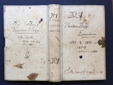 Beaufort Historical Society
Work on paper - Ledger, Theodore Beggs Eurambeen No. 1 1877-1881, 1877
Small, c. 7"x 4", 253 p., cloth boundeurambeen -victoria, beaufort - people, beaufort - history, pastoral industry - victoria, beggs family, chinese - beaufort