Showing 158 items matching "residential garden"
-
 Department of Health and Human Services
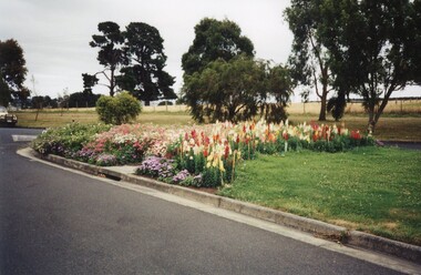
Photograph, Colanda grounds - main driveway gardens
The Colac, Victoria-based Colanda Centre was one of the last Victorian institutions and offered disability accommodation from 1976, when it was established, until 2019, with its closure.Digitised colour photograph of Colanda's main driveway gardens. colanda, colac, disability services, residential services, disability, digitised photograph -
 Ballarat Tramway Museum
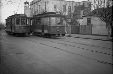
Negative, Wal Jack, mid 1940's
Negative and Digital images of the Wal Jack Geelong Negative file of Geelong trams 2 and 10 crossing at the Retreat Rd loop in Pakington St, just north of Aphasia St. Tram 2 - has destination of Newtown and 10, East. In the background is 271 Pakington St - City of Newtown and Chilwell offices, in 2020, a Residential property. Photo mid 1940's. trams, tramways, geelong, pakington st, aphasia st, tram 2, tram 10 -
 Bayside Gallery - Bayside City Council Art & Heritage Collection
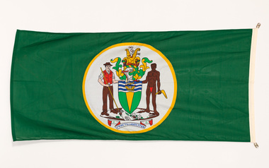
Flag, Evan Evans, City of Brighton flag
The coat of arms on this flag were granted by the British College of Arms in 1970 and represented Brighton City Council's "growing awareness of the importance of formality and correct symbolism in local government". It replaced the council's crest of a pier and yachting scene and was used as council's seal, emblem on its flag and letterhead. The new Coat of Arms, drawn up by the College of Arms in England, depicts the progression from a seaside gardening community to a modern residential city. The prominent forms are on the shield-like coat of arms include waves and a Lymphad (a ship, symbolic of the sea); a market gardener; an aboriginal man; two horns of plenty with abundant fruit and vegetables (the wealth and plenty) and Elster Creek (now Elster Canal). It is underscored by the motto "By their fruits, ye shall know them". Brighton was first incorporated as a borough on 18 January 1859, it became a town on 18 March 1887 and was proclaimed a city on 12 March 1919.Green flag with circular City of Brighton Coat of Arms in the centre. The central circle is white with a yellow edge, with a polychrome coat of arms featuring: the crest which is two cornucopia with fruits and vegetables, above sits a seagull. The mantle above the helmet is in green and gold. The shield is also green and gold with a lymphad (ship) and blue and white waves. The market gardener, holding a hoe, and Aboriginal figure, bearing a boomerang, support the shield and stand upon the compartment which is soil with a representation of Elster creek. A ribbon below contains the motto in blue 'FRUCTU NOSCITUR'.flag, brighton, city of brighton, coat of arms, college of arms, market gardener, aboriginal, elster creek, lymphad, fructu noscitur, armorial bearings, heraldry, cornucopia, by their fruits ye shall know them, motto -
 Kew Historical Society Inc
Photograph, J F C Farquhar, Studley Park Road, 1891
At the beginning of the 1890s, the Kew businessman and Town Councillor, Henry Kellett, commissioned J.F.C. Farquhar to photograph scenes of Kew. These scenes included panoramas as well as pastoral scenes. The resulting set of twelve photographs was assembled in an album, Kew Where We Live, from which customers could select images for purchase.The preamble to the album describes that the photographs used the ‘argentic bromide’ process, now more commonly known as the gelatine silver process. This form of dry plate photography allowed for the negatives to be kept for weeks before processing, hence its value in landscape photography. The resulting images were considered to be finely grained and everlasting. Evidence of the success of Henry Kellett’s venture can be seen today, in that some of the photographs are held in national collections.It is believed that the Kew Historical Society’s copy of the Kellett album is unique and that the photographs in the book were the first copies taken from the original plates. It is the first and most important series of images produced about Kew. The individual images have proved essential in identifying buildings and places of heritage value in the district.In this view of Studley Park Road, looking northeast to the Junction, the photographer invites the viewer to participate in a point-of-view that emphasises the elevated, tranquil vantage point of the hill in contrast to the bustling commercial area in the distance. The view emphasises the exclusiveness of Studley Park, with its high fences behind which a number of significant Kew mansions were concealed. Contemporary advertisements for the sale of mansions in Studley Park Road often included fulsome descriptions of their elaborate formal gardens, as well as paddocks for grazing, stabling and dairies. None can be seen here. The use of high, protective wooden pickets to surround the newly planted avenue of elms on the south side of the road appears to be typical of the period. Similar examples can be seen in early photographs of Wellington and Princess Streets.The horse and carriage, selected as a central focus of the view, reinforces the residential, exclusive nature of this part of Kew in the early 1890s. Studley Park Roadkew illustrated, kew where we live, photographic books, henry kellett -
 Kew Historical Society Inc
Photograph, J F C Farquhar, A View in Studley Park Road, 1891
... Park Road and Stevenson Street, including gardens laid out... Park Road and Stevenson Street, including gardens laid out ...At the beginning of the 1890s, the Kew businessman and Town Councillor, Henry Kellett, commissioned J.F.C. Farquhar to photograph scenes of Kew. These scenes included panoramas as well as pastoral scenes. The resulting set of twelve photographs was assembled in an album, Kew Where We Live, from which customers could select images for purchase.The preamble to the album describes that the photographs used the ‘argentic bromide’ process, now more commonly known as the gelatine silver process. This form of dry plate photography allowed for the negatives to be kept for weeks before processing, hence its value in landscape photography. The resulting images were considered to be finely grained and everlasting. Evidence of the success of Henry Kellett’s venture can be seen today, in that some of the photographs are held in national collections.It is believed that the Kew Historical Society’s copy of the Kellett album is unique and that the photographs in the book were the first copies taken from the original plates. It is the first and most important series of images produced about Kew. The individual images have proved essential in identifying buildings and places of heritage value in the district.This is the earliest known photograph of the exterior of Byram (later Tara Hall). It shows the original red brick fence, its asymmetrical gate and gateposts, with a large terra cotta gargoyle surmounting the higher of the two. The architect, Edward Kilburn designed Byram in the Arts & Crafts style for the industrialist George Ramsden. Construction began in 1888 and was reputed to have lasted three years. The mansion had frontages to Studley Park Road and Stevenson Street, including gardens laid out with great taste, including pleasure grounds, tennis lawn, fruit and flower garden, and paddock. The size of many of the trees in the garden indicate that many survived from the garden of Clifton Villa, the previous single-storeyed house built on the site by the Stevenson brothers. Byram had views to Melbourne and Port Phillip Bay. The house was demolished in 1960, despite opposition from the National Trust (Victoria), and its gardens subdivided into residential allotments.A View in Studley Park Roadkew illustrated, kew where we live, photographic books, henry kellett, byram, tara hall, goathlands -
 Kew Historical Society Inc
Photograph - 'Clutha', Studley Park Road, 1860-1890
Clutha was the home of John Carson, the second mayor of Kew. Leonard Terry designed the house for him in 1856. Terry was the architect of the Melbourne Club (1858), the former London Chartered Bank (1861), Lothian Terrace in Carlton (1865), and the ES&A Bank in Hawthorn (1873). The commission for Clutha was won three years after Terry’s arrival in Victoria.An extremely rare photograph of a major residential architectural commission of Leonard Terry. The photograph of the house has statewide significance as the home of the Victorian pioneer and businessman, John Carson. A rare, nineteenth century photograph of ‘Clutha’ in Studley Park Road, Kew. The sepia-toned photograph is of the front of the house, with its bluestone foundations and its second storey balcony. A real estate advertisement in 1875 described the house as: 'First-class family mansion, and about 8½ acres of pleasure grounds and fruit garden. The house, erected under the plans and supervision of Mr. Leonard Terry, is most substantially built of brick, stuccoed, on solid bluestone pediment, forming a noble basement story, large entrance hall, and lobby, with conservatory on the left. *** A wide verandah and balcony, erected on cast-iron columns, runs round the house, the views from which are perhaps unequalled in extent and beauty in the neighbourhood of the city, commanding the bay, shipping, Mount Macedon, and Dandenong Ranges. Th e whole forming a most complete gentleman's residence, no expense having been spared in its erection and comfortable finish.'"Clutha West Side Studley Park Road Kew / Clutha West Side"clutha, john carson, leonard terry -
 Kew Historical Society Inc
Journal, Kewriosity : April 1990
Rates reminder / p1. The greening of Kew / p1. Dates for April / p2. Dog fees due / p2. Streetscaping plan / p3. Commentary / Cr Michael Montalto / p3 Residential policies review / p3 . Community bus / p3. High Street parking changes / p3. [Easter] Holiday Program / p4. Library corner / p4. Notices [Anniversary fete] / p4. The view from the dome [Sacred Heart Church] / p4. Car control course for young drivers / p4. Singles talk / p4. Anzac Day / p5. Office [development] Policy launched / p5. Federal Minister in firing line [Family Day Care programs] / p5. Possums playgroup / p5. World focus on literacy this year / p6. Credit card debt a nightmare / p6. Garden weddings fee [Alexandra Gardens] / p6. Siena [College] is 50 / p6. Painting for Kew Library [Studley Park Conservation Society, Louise Folleta - 'Yarra River at Studley Park'] / p7. One year on for women's club [Kew Ladies Probus Club] / p7. In Brief / p7. Council strengthens YMCA links [Kew Recreation Centre] / p7. Neighbourhood Watch / p8. Traffic Management update / p8. Consumer matters / p8. Back care seminar / p8. Introducing the "Fact Pack" [Youth Services] / p8.Kewriosity was a local newsletter combining Kew Council and community news. It was published between November 1983 and June 1994, replacing an earlier Kewriosity [broad] Sheet (1979-84). In producing Kewriosity, Council aimed to provide a range of interesting and informative articles covering its deliberations and decision making, together with items of general interest and importance to the Kew community and information not generally available through daily media outlets.non-fictionRates reminder / p1. The greening of Kew / p1. Dates for April / p2. Dog fees due / p2. Streetscaping plan / p3. Commentary / Cr Michael Montalto / p3 Residential policies review / p3 . Community bus / p3. High Street parking changes / p3. [Easter] Holiday Program / p4. Library corner / p4. Notices [Anniversary fete] / p4. The view from the dome [Sacred Heart Church] / p4. Car control course for young drivers / p4. Singles talk / p4. Anzac Day / p5. Office [development] Policy launched / p5. Federal Minister in firing line [Family Day Care programs] / p5. Possums playgroup / p5. World focus on literacy this year / p6. Credit card debt a nightmare / p6. Garden weddings fee [Alexandra Gardens] / p6. Siena [College] is 50 / p6. Painting for Kew Library [Studley Park Conservation Society, Louise Folleta - 'Yarra River at Studley Park'] / p7. One year on for women's club [Kew Ladies Probus Club] / p7. In Brief / p7. Council strengthens YMCA links [Kew Recreation Centre] / p7. Neighbourhood Watch / p8. Traffic Management update / p8. Consumer matters / p8. Back care seminar / p8. Introducing the "Fact Pack" [Youth Services] / p8. publications -- city of kew (vic.), kewriosity, council newsletters, community newsletters -
 Kew Historical Society Inc
Plan - Subdivision Plan, Raheen Estate Subdivision, 1960
Subdivision plans are historically important documents used as evidence of the growth of suburbs in Australia. They frequently provide information about when the land was sold on which a built structure was subsequently constructed as well as evidence relating to surveyors and real estate and financial agents. The numerous subdivision plans in the Kew Historical Society's collection represent working documents, ranging from the initial sketches made in planning a subdivision to printed plans on which auctioneers or agents listed the prices for which individual lots were sold. In a number of cases, the reverse of a subdivision plan in the collection includes a photograph of a house that was also for sale by the agent. These photographs provide significant heritage information relating house design and decoration, fencing and household gardens.The Raheen Estate Subdivision of 1960 involved the creation of 36 residential allotments and the sale of 34 of these. The land on which the subdivision was created had until 1960 formed part of the grounds of the mansion Raheen in Studley Park Road. In 1917, the Catholic Church had purchased Raheen and its lands. It was to become the home of Archbishop of Melbourne, Daniel Mannix, for 46 years. The sale of the subdivision took place three years before the Archbishop’s death. Subsequent archbishops were to reside at Raheen until its sale to the Pratt family in 1981. When the sale of the Estate was reported in the newspapers in 1960, it was described as the last big subdivision near Melbourne. At the auction, 33 of the 36 allotments were sold. The auction realised £315,750. Purchasers were advised that the vendor intended to keep lots 22 and 23. The alllotments in the subdivision required the construction of new roads. These included Eamon Court and Raheen Drive. The justification provided by the Church for the sale was that the estate was being sold to finance school building projects.subdivision plans - kew, studley park, raheen estate, eamon court, studley park road, coombes avenue, raheen drive -
 Kew Historical Society Inc
Plan, J R Mathers & McMillan, 5 Splendid vVlla Allotments,: Segtoune St. & Windsor St., Kew, 1928
Prue Sanderson, in her groundbreaking ‘City of Kew Urban Conservation Study : Volume 2 - Development History’ (1988), summarised the periods of urban development and subdivisions of land in Kew. The periods that she identified included 1845-1880, 1880-1893, 1893-1921, 1921-1933, 1933-1943, and Post-War Development. These periods were selected as they represented periods of rapid growth or decline in urban development. An obvious starting point for Sanderson’s groupings involved population growth and the associated economic cycles. These cycles also highlighted urban expansion onto land that was predominantly rural, although in other cases it represented the decline and breakup of large estates. A number of the plans in the Kew Historical Society’s collection can also be found in other collections, such as those of the State Library of Victoria and the Boroondara Library Service. A number are however unique to the collection.Subdivision plans are historically important documents used as evidence of the growth of suburbs in Australia. They frequently provide information about when the land was sold on which a built structure was subsequently constructed as well as evidence relating to surveyors and real estate and financial agents. The numerous subdivision plans in the Kew Historical Society's collection represent working documents, ranging from the initial sketches made in planning a subdivision to printed plans on which auctioneers or agents listed the prices for which individual lots were sold. In a number of cases, the reverse of a subdivision plan in the collection includes a photograph of a house that was also for sale by the agent. These photographs provide significant heritage information relating house design and decoration, fencing and household gardens.In 1928, five residential allotments bordering Segtoune and Windsor Streets were advertised for sale as part of a subdivision. Four of the blocks faced Segtoune Avenue. The auctioneers proclaimed the advantages of the sites: ‘Situate one minute from the High Street Electric Tram, which now runs direct to Spencer Street via Bridge Road and Flinders Street. Opposite the East Kew Railway Station (Outer Circle Line), which may be reopened In connection with the new Line from Kew to Doncaster; Adjacent lo the Kew Recreation Reserve, Sports Oval, and Swimming Bath; Half Minute from the Shopping Centre of East Kew, Accessible to the State School and Other Educational Centres’. The Harp of Erin Hotel and the route of the Outer Circle Railway line are marked on the plan. The Recreation Reserve and Sport Oval refer to Victoria Park. The Swimming Baths were located on the site of the current Kew Recreation Centre.subdivision plans - kew, segtoune street -- kew (vic.), windsor street -- kew (vic.) -
 Kew Historical Society Inc
Photograph, 'Goathland', The Residence of Sir Malcolm D McEacharn, 1901-1911
... (Victoria), and its gardens subdivided into residential allotments.... Park Road and Stevenson Street, including gardens laid out ...The architect, Edward Kilburn designed Byram in the Arts & Crafts style for the industrialist George Ramsden. Construction began in 1888 and was reputed to have lasted three years. The mansion had frontages to Studley Park Road and Stevenson Street, including gardens laid out with great taste, including pleasure grounds, tennis lawn, fruit and flower garden, and paddock.The size of many of the trees in the garden indicate that many survived from the garden of Clifton Villa, the previous single-storeyed house built on the site by the Stevenson brothers. Byram had views to Melbourne and Port Phillip Bay. The house was demolished in 1960, despite opposition from the National Trust (Victoria), and its gardens subdivided into residential allotments.An early photograph of Goathland (also known as Byram, Lowan and Tara Hall). The photo shows the front of the building during the period of Sir Malcolm McEacharn’s occupation of the house (1901-11). Edward George Kilburn, of Ellerker & Kilburn, had originally designed the house for the industrialist George Ramsden in 1888. When Sir Malcolm McEacharn purchased Byram, he was to rename it as Goathland. This has led to some confusion, as Goathland was also the name used for McEacharn’s other home in St. Kilda. The period of McEacharn’s ownership represented the high point of the mansion’s history. 'Lost Glories: a memorial to forgotten Australian buildings' was published by David Latta in 1986. It tells the story of a number of significant Australian buildings that had previously been demolished. A chapter in the book was devoted to Goathland, later known as Tara Hall. To supplement the text, he sourced photographs from a range of suppliers, chiefly the Royal Women's Hospital which had once owned Tara Hall, but had sold it in 1960. This is one of the photographs donated to KHS by the author."'Goathland', The Residence of Sir Malcolm D McEacharn"byram, goathland, tara hall, lowan, studley park road -- kew (vic.), melbourne mansions, e g kilburn - architect -
 Surrey Hills Historical Society Collection
Photograph, Surrey Hills - Looking East from Essex Road, circa 1900, c1900
... Gardens. edwardian style residential development kirkland essex ...Date is approximate. Two original post cards of this image - "Surrey Hills - looking East" - were donated by Stephen Wyatt on 10 March 2012. One is blank; the other has been sent to Mrs A Wyatt, C/O Mrs E Young, 'Grand View', Warburton from daughter Nellie from 'The Quantocks', Surrey Hills - postmarked 10 Dec 1906. There is also a reproduction of this image in a framed collage of Surrey Hills photos.This is the earliest known image of the Surrey Gardens. The layout was originally designed by William Guilfoyle, who also designed Melbourne’s Royal Botanic Gardens.Black and white photo taken from an early postcard. Taken from the roof of a house in Essex Road, it shows the development of housing between Essex and Union Roads and includes the section of land fenced off for the Surrey Gardens with paths roughly laid out, one existing tree but no tree planting. The houses depicted are largely Edwardian timber buildings with corrugated rooves. There are still some vacant blocks. Kirkland on Union Road can be seen in the distance, as can some of the shops along Canterbury Road.Lower LHS within original image: " Surrey Hills - Looking East"; on the rear "No 17" in black pen in top LH corner.edwardian style, residential development, kirkland, essex road, suffolk road, norfolk road, surrey gardens, post card -
 Surrey Hills Historical Society Collection
Book, A history of Camberwell, 1980
In 1964 Camberwell City Council commissioned Professor Geoffrey Blainey to first write this history. Since that time, many changes have taken place and therefore the Council asked Professor Blainey to bring the book up to date. Bibliography, includes index. The author presents a century of pioneering development and endeavours. He has traced the coming of the wood-cutters and the farmers, the transition from rectangular paddocks to a grid of roads and streets, the growth from shire to borough, town and city, the filling up of thirteen squares miles into residential suburbia - in successive waves of invasion, along new transport routes - including the Outer Circle Railway. Substantial chapters cover the War Years and the progress of Camberwell since the 1960s have also been included in this edition. 134p; ill;camberwell, victoria, market gardens, tolls, railways, mayors, boroondara road board, borondara shire, councillors, (mr) (prof) geoffrey blainey -
City of Kingston
Photograph - Colour, 6 March 1993
... in the area now known as Aspendale Gardens and the newer residential... in the area now known as Aspendale Gardens and the newer residential ...Edithvale is a suburb in the City of Kingston. It is located between Aspendale and Chelsea on the Port Phillip Bay and built within remnant areas of the Carrum Carrum swamp. The foreshore precinct comprises a wide sandy beach, with low sand dunes and numerous historic boat sheds. The suburb consists of older style dwellings and former holiday houses, combined with mid-century housing and newer homes. The large blocks are increasingly subdivided and the existing dwellings demolished to accommodate units and townhouses, thus changing the landscape of the area and reducing the tree canopy.The beachside suburb of Edithvale was previously part of the extensive Carrum Carrum Swamp. The area was once a source of fish and eels for the Mayone-Bulluk clan of the Bunurong people. Over time the area was drained and predominantly devoted to dairy farming and holiday houses. The farms were gradually sold and subdivided with a large number of homes built after World War II and in the 1960s. Edithvale is mainly residential with a shopping strip along Nepean Highway but little significant industry was ever established in the area apart from a plaster works and confectionary factory, both now closed.Laminated aerial colour photograph of Edithvale as viewed from Alexandra Avenue in the north to Ella Grove Chelsea/Edithvale in the south. regents Park Aspendale can be seen in the top left. The area is built-up with residential housing and facilities including Edithvale Primary School, numerous churches and the Edithvale Railway station. Large sections depict the remnant Carrum Carrum swamp. Edithvale Common and the former "Duck Inn" (Melbourne Water/Friends of Edithvale Seaford Wetlands) can be seen. Edithvale Recreational reserve, the valodrome and Edithvale Public Golf Course are prominent. The image shows vacant land in the area now known as Aspendale Gardens and the newer residential section of Chelsea Heights is not developed. A bike path has been established to cover the secondary drain. The Golf Links Court residential development located off Hughes Avenue is a large vacant block.Black type on white adhesive label: 6-3-93 Black type on white adhesive label: 25/9211, 6/3/93, 11.20 am Black type on white adhesive label: 9211 Yellow circular adhesive sticker Black pencil: 9211 6-3-93 arrow pointing Nedthvale, carrum carrum swamp, aspendale, chelsea -
City of Kingston
Photograph - Black and white, 3 March 1954
Cheltenham and Moorabbin are suburbs within the City of Kingston that were originally established as rural market gardening communities The area is bordered by Highett and Mentone. The market gardens, farms and paddocks have gradually been sub-divided into housing and industrial estates. Highett is developed with residential homes but was also the site of major facilities such as the Highett Gas Works. This aerial image covers a diverse section of the City of Kingston, taking in the suburbs of Moorabbin, Cheltenham, Highett and Mentone Residential housing development is prominent along the Frankston Railway line and the area still retains extensive market gardens and paddocks yet to be converted to a large industrial and commercial zone.Aerial photograph of Mentone, Cheltenham and Moorabbin within the City of Kingston. The area depicted in this 1954 aerial view includes Warrigal Road and Centre Dandenong Road intersection (top left); Charman Road, Patty Street, Bourke Street, Collins Street Mentone (top right); Keys Road Moorabbin (bottom left); Bay Road, Cheltenham (bottom right), Friendship Square, Cheltenham Park, Victoria Golf Club and Jack Barker Oval are visible. Nepean Highway and the Frankston railway line run centrally through the image. Highett Gasworks is also evident.White handwriting and type [indecipherable]. White image of clockface White image of compass White type 42956 Black handwriting 3/3/54 Williams [indecipherable] Black pencil: S [arrow] Black ink: 3/3/1954cheltenham, moorabbin, mentone, highett, market gardens -
 City of Kingston
Photograph - Black and white, c. 1920
Horse and wagon were used to haul produce from the market gardens of the area now known as Kingston into Melbourne city for sale, well into the 20th Century. From about 1910 onwards, motorised transport became increasingly popular.Black and white image featuring a woman standing in front of a fully loaded wagon, with a man sitting atop the load and holding the reins. There are three horses harnessed to the wagon. It appears to be a residential street with a picket fence in front of a hedge in the background, along with what appears to be an electricity pole.Handwritten in blue ink on reverse: 67 [inside a hand drawn circle] Handwritten in red ink: 80%horses, horse drawn wagon, transport, market -
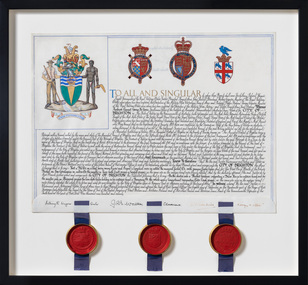 Bayside Gallery - Bayside City Council Art & Heritage Collection
Document - Certificate, College of Arms, City of Brighton Coat of Arms, 1970
The Coat of Arms, represents Brighton City Council's "growing awareness of the importance of formality and correct symbolism in local government". It replaced the council's crest of a pier and yachting scene and was used as council's seal, and emblem on its flag and letterhead. The new Coat of Arms, drawn up by the College of Arms in England, depicts the progression from a seaside gardening community to a modern residential city. The prominent forms are on the shield-like coat of arms include waves and a Lymphad (a ship, symbolic of the sea); a market gardener; an aboriginal man; two horns plenty with abundant fruit and vegetables (the wealth and plenty) and Elster Creek. It is underscored by the motto 'By their fruits, ye shall know them'. Brighton was first incorporated as a borough on 18 January 1859, it became a town on 18 March 1887 and was proclaimed a city on 12 March 1919.Ink and gouache on parchment with wax seals. Allocates a Coat of Arms to the City of Brighton, by the College of Arms in London on 08/09/1970. The Coat of Arms is located on the upper left quadrant and has the following parts: the crest, the wreath, the helmet and mantle, the shield, the supporters, the compartment and the motto. The crest is two cornucopias with fruits and vegetables, above which sits a seagull. The mantle above the helmet is in green and gold. The shield is also green and gold with a lymphad (ship), and blue and white waves, representing the sea. The market gardener, holding a hoe, and Aboriginal figure, bearing a boomerang, support the shield and stand upon the compartment which is soil with a representation of Elster Creek. A ribbon below contains the motto in 'FRUCTU NOSCITUR'. The certificate text explains the origins of Brighton and the parts of the coat of arms. At the bottom of the folded parchment are three signatures and titles, below which three red wax seals in gold tin containers hang from blue ribbons.coat of arms, certificate, city of brighton, college of arms, market gardener, aboriginal, wax seal, elster creek, lymphad, fructu noscitur, letters patent, armorial bearings, heraldry, seal -
![Map, Plan of Town Allotments Bacchus Marsh [1873]](/media/collectors/5e461d8021ea67224c82f2a1/items/677a8ee7ab7bb47995c5573f/item-media/677a8fdeab7bb47995c55b56/item-fit-380x285.jpg) Bacchus Marsh & District Historical Society
Bacchus Marsh & District Historical SocietyMap, Plan of Town Allotments Bacchus Marsh [1873]
James Young was a prominent businessman, land owner and public figure in the early colonial period of Bacchus Marsh. After his death in 1871 land remaining from his estate in Bacchus Marsh was sold at auction in 1873. The sale of his estate included the substantial stone residence in Bennett Street which later became known as 'Stone Villa'. The sale of his land in 1873 was conducted by local auctioneer James Crook. 29 allotments were advertised for sale, although the plan for the sale indicated 30 allotments. The sale notice in the Bacchus Marsh Express of 11 October 1873 noted that the allotments were " in the very centre and heart of the most populous and business portion of the township, at the same time being the only remaining portion of the business block available for purchase by public sale, which fact intending purchasers should not lose sight of, as the opportunity cannot occur again". The designation of a new street, 'Bennett Street', shown on the plan, is also indicated in the advertising, "In reference to the main street frontages, opposite the Border Flour Mills. The Auctioneer would also direct attention to the plan, showing the formation of a new thorough fare (Bennett street) leading from Young street into Gell street, thus opening up the township on the high, more healthy, and commanding position so much to be desired for private dwellings".An important cartographic document which indicates an early major subdivision of land in the inner urban area of the Bacchus Marsh township. This subdivision lead to the continuing residential and commercial development of the township of Bacchus Marsh in the later part of the 19th century. The location of two well known demolished public structures, the Free Gardeners Hall in Gell Street, and the Old Mechanics Institute Hall (aka the Buffs Hall), on the corner of Young and Bennett Streets, are also shown on this map.A single page paper map showing 30 blocks of land for sale around 1873 in the vicinity of Bennett Street and Lerderderg Street. Described in contemorary sources as a 'lithographed copy'. No scale is indicated. The map is pasted into a bound volume containing 76 maps or plans in total. High resolution digital image stored on BMDHS computer network. land sales bacchus marsh, bacchus marsh victoria maps, james young 1816-1871, bacchus marsh roads and streets, bennett street bacchus marsh -
 Surrey Hills Historical Society Collection
Work on paper - Photograph, 50 Broughton Road, Surrey Hills, c1924
Information from the donor by email gives: My grandparents Norman & Hilda Pryde lived at 50 Broughton Rd, Surrey Hills. The home was named 'Strathaven' after the town in Scotland where Norman's father came from. They married in 1923. I know they lived there in 1924 when my mother Norma was born. Norman worked for Moran & Cato so I know they moved around a lot for his work and I think they rented out the house from time to time. During some time in the 1920s they were listed on electoral rolls in Nyah West and then in 1942 they were listed in Hamilton. When the war ended they came back to Melbourne and in the late 1940s built a home at Blackburn. Their daughter was at school in Grade 6 at Surrey Hills State School in 1935. See related photo. At the time of the donation, this simple home was still extant. Since then, c2021, it was demolished and replaced by a large single dwelling.This photo is representative of the simple interwar home that infilled earlier scattered residential development in this part of Surrey Hills.An original B&W photo of a simple timber home set behind a woven wire fence and taken from across the street. The garden looks relatively undeveloped.NILbroughton road, surrey hills, norman pryde, hilda pryde, hilda gwendoline scales, 'strathaven', house names, 1920-1929, moran & cato, norma pryde, norma cleak, jenny pomeray, interwar housing -
 Bendigo Historical Society Inc.
Photograph - STONE COTTAGE
BHS Collectionblack and white photo reprint. Rendered stone cottage, two double doors to front. Render partly worn away with stone visible. Corrulaged iron roof, sleepout on LH of verandah. Brick wall with ladder against. Remains of cast iron to verandah, cast iron table with plants. Aspidistras in garden beds with roses.buildings, residential, stone cottage -
University of Melbourne, Burnley Campus Archives
Newspaper - Newspaper Cutting, The Leader, Horticultural Gardens and School, 1896
Copy of article in "The Leader" (Melbourne) ("by our special reporter") on 25 January, 1896 p13. Discussion of advantages of the course at the School of Horticulture including free tuition, non-residential. Currently 18 students. Practical tuition by Mr Neilson and scientific by Mr McAlpine. Long description of subjects studied and method of growing fruit trees.the leader, school of horticulture, mr neilson, mr mcalpine, subjects, subject descriptions, fruit tree growing, students -
 Bendigo Historical Society Inc.
Photograph - T C WATTS & SON COLLECTION: WHITE HILLS, NEXT TO CATHOLIC SCHOOL, 1927
BHS CollectionBlack and white photograph mounted on rectangular brown board. House, weatherboard , triple gabled corrugated iron roof, single chimney , wooden return verandah with balustrade, capitals to verandah posts. Exterior windows have awnings, two entrances from returned verandah, two deckchairs and hammock on verandah. Rock-bordered garden R.H. corner. Written on back of photo ' Roberts, White Hills, £1150 (crossed out) £850, next R.C. School'F.A. Jeffree, Bendigoresidential, roberts, white hills, t.c. watts and son, 1927 -
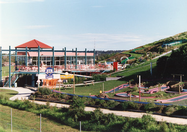 Lakes Entrance Historical Society
Photograph - Kinkuna, 2009
Kinkuna Amusement Park was opened 19 December 1987, closed 2002, building demolished or removed, land sold and subdivided into residential allotments.Copy colour photographic print showing Kinkuna Amusement Park on Princes Highway, owned by Joe and Shirley Walters. Photo shows main building and restaurant, mini golf, long taboggan on hill, garden and other attractions. Lakes Entrance Victoriaentertainment, recreation -
 Eltham District Historical Society Inc
Photograph - Digital Photograph, Marguerite Marshall, Sutherland Home for Children, Diamond Creek, 27 September 2007
The Sutherland Homes for Children on Yan Yean Road, Diamond Creek cared for thousands of children from when it was opened in 1912. The site closed for this purpose in 1991 and was sold and later developed for commercial and office purposes. Covered under Heritage Overlay, Nillumbik Planning Scheme. Published: Nillumbik Now and Then / Marguerite Marshall 2008; photographs Alan King with Marguerite Marshall.; p107 The Sutherland Homes for Children at 14 Yan Yean Road, Diamond Creek, cared for thousands of children since they opened in 1912, after beginning at La Trobe Street, Melbourne in 1908. In 1994 Sutherland Homes (then called Sutherland Child, Youth and Family Services) amalgamated with Berry Street Child and Family Welfare. Together as Berry Street Victoria, they formed Victoria’s largest independent provider of support and accommodation services for children, young people and families in crisis.1 However with the move from institutional to community care, the Diamond Creek site had not been used since 1991 and was sold to private purchasers in 1999. More than 2000 former residents, staff, neighbours and friends attended a farewell in February, 2000.2 The Sutherland Homes red-brick and stuccoed building in Diamond Creek (a rare design in the Eltham Shire), was opened in 1929 by Lord Somers, the Governor of Victoria. Destitute children lived in dormitories bathed in natural light through large windows. However in 1958 as the cottage–parent system replaced the dormitory system, the first of eight residential cottages accommodating ten to 12 children was built. The site also included Special School 3660 and a farm, and the children were able to form relationships with people outside Sutherland, by staying with holiday hosts. Children were originally placed at Sutherland because of extreme poverty, or because single parents could not cope. However later, most placements occurred due to family violence, abuse or neglect. The property was originally bought from the Crown in 1869 by Timothy Mahony. Later owner, Augusta Meglin, ran a 40-acre (16ha) farm there. In 1909 she bequeathed this, including the house, orchards, vegetable gardens, vineyards and the balance of her income to The Sutherland Homes for Neglected Children. Sutherland Homes’ founder, Selina Sutherland, was known as ‘New Zealand’s Florence Nightingale’. In 1888 she became Victoria’s first licensed ‘child rescuer’3 and was to rescue around 3000 waifs from Victoria’s streets and slums.4 Born in Scotland in 1839, Sutherland joined her sister, who had emigrated with her husband to New Zealand. Sutherland trained as a nurse and led the establishment of a public hospital at Masterton. In 1881, while holidaying in Melbourne, Sutherland was so touched by seeing young people living under Princes Bridge, that this determined her future work. Meanwhile Sutherland instigated the Melbourne District Nursing Society, (now Royal District Nursing Service). She also led the founding of The Victorian Neglected Children’s Aid Society (now Oz Child) and the Presbyterian Neglected Children’s Aid Society (now Kildonan). From 1894 Miss Sutherland was Melbourne’s best known woman and cut a distinctive figure, wearing an alpine hat with a prominent feather. In 1906 Prime Minister Alfred Deakin named her Melbourne’s most successful philanthropic worker. However she was to face some difficult times. That year she suffered severely from an injured shoulder and dizzy turns and was pressured to resign as Superintendent of The Victorian Neglected Children’s Aid Society. In 1908 the committee of management offered her 12 months leave with pay. Sutherland declined – but soon after, was dismissed. However she continued her work from Latrobe Street, Melbourne, with the help of Sister Ellen Sanderson and several committee members. Sutherland attempted to register her new organisation but the Victorian Neglected Children’s Aid Society objected to the government, alleging that Sutherland, because of increasing infirmity, was unable to satisfactorily carry out such duties. They accused her of cruelty and of intoxication. However the charges were not proven, so The Sutherland Homes for Neglected Children was registered.5 Sadly, in 1909 Sutherland died, the day she was to move the children to the ‘country property’ at Diamond Creek. At her death she owned less than £10. Today Berry Street recognises Sutherland’s enormous contribution to child welfare with a memorial and an annual Selina Sutherland Award, presented to an outstanding volunteer.This collection of almost 130 photos about places and people within the Shire of Nillumbik, an urban and rural municipality in Melbourne's north, contributes to an understanding of the history of the Shire. Published in 2008 immediately prior to the Black Saturday bushfires of February 7, 2009, it documents sites that were impacted, and in some cases destroyed by the fires. It includes photographs taken especially for the publication, creating a unique time capsule representing the Shire in the early 21st century. It remains the most recent comprehenesive publication devoted to the Shire's history connecting local residents to the past. nillumbik now and then (marshall-king) collection, diamond creek, sutherland home for children -
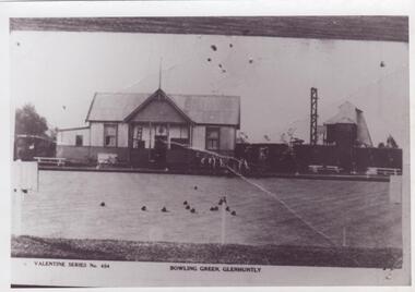 Glen Eira Historical Society
Document - Glen Huntly Bowling Club
This file contains two items about this club: 1/An eight page document named The Glen Huntly Bowling Club Jubilee Story. It is a historical account by Russell H. Keon-Cohen M.A. dated February 1964. It also describes the history of the region for fifty years. 2/Undated original black and white photograph of Glen Huntly Bowling Club.railways, caulfield, tramways, glen huntly road, glenhuntly road, grange road, mcdowing’s butcher shop, neerim road, residential development, rosstown railway, glen huntly, glen huntly hall, racecourses, pearce’s national rose gardens, bowling clubs, jones s.c., quinn mr., ellis mr., descrimes mr., kitchen cr., brookshaw cr., bowling clubs, glen huntly bowling club, ellis w., fulton t.j., lass r., newton t., pelzer p., rider h., sayer j., thomas h., boyd j.a., deans mr., gorgan thomas, woods h.s., rider mr., maxwell mr., hardnam mr., sportsgrounds, madden frank, meirest j.k., eggleston frederick, bell w., breamer b.j., carrol w., dall w.m., dunn w., mortan thomas, philips r.l., stork a.m., wells h.j., organisations, progress organisations, billiard rooms, refreshment rooms, harrison r.t.a., jones mr., glen eira mcminnon bowls club, sports, sporting clubs, jubilees, festivals and celebrations, finance, pavilions -
 Bendigo Historical Society Inc.
Photograph - T C WATTS & SON COLLECTION: VIOLET STREET BENDIGO, 1929
BHS CollectionBlack and white photographs (2) , mounted on rectangular grey board. House, rendered with porch with decorative gable, slate roof, 2 chimneys, established garden with rock edging. Written on back of photo board ' Geo. Every, Violet Street, 875 pounds' On back of record date stamp 27 April 1929. Note attached to record ' this house was originally kitchen and staff quarters of Alexander Bayne's house "Montanvert" ( from Myrtle Street to Violet). Address of Alexander Bayne's former house, of which this house was formerly part of, is 84 Violet Street, Bendigo.Frank A. Jeffree, Bendigoresidential, alexander bayne, violet street, bendigo, george every -
University of Melbourne, Burnley Campus Archives
Plan, Mont Calm, 1995
... Plans for Garden Courtyard in a residential home, "Mont... for Garden Courtyard in a residential home, "Mont Calm," Prospect ...Plans for Garden Courtyard in a residential home, "Mont Calm," Prospect Hill Road, Surrey Hills. Student assignment dated 13.02.1995. (1) Assignment details. (2) Student rough notes. (3) Outline on tracing paper. (4) Rough sketch. (5) "Paving to Northern Courtyard."mont calm, surrey hills, garden design, courtyard garden -
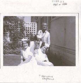 Northern District School of Nursing. Managed by Bendigo Historical Society Inc.
Document - Personal memoir
The Northern District School of Nursing opened in 1950 in to address the issues around nurse recruitment, training and education that had previously been hospital based. The residential school was to provide theoretical and in-house education and practical training over three years. The students would also receive practical hands-on training in the wards of associated hospitals. The Northern District School of Nursing operated from Lister House, Rowan Street, Bendigo. It was the first independent school of nursing in Victoria and continued until it closed in 1989. The book "The First of its Kind" was published in 2015. Printed in Bendigo by "Bendigo Modern Press". Memories compiled by Peter Rosewall; who attended the last NDSN school PTS 108 between 1986 - 89.Three items submitted by Charles Hemley. Included is a letter submitted in personal handwriting by Charles Hemley who was the gardener at NDSN from 1976 to 1989 for the last 13 years. He describes his duties as the gardener and his training consisted of four years of night school at Bendigo TAFE. Included are a photograph of nurses and a gardener sitting on the lawn. Include a newspaper article about Lister House from the Bendigo Advertiser. The photograph has a car parked out the front and the title is Bendigo - The Way we were. There is a brief history of Lister House.memoir, nursing, at lister house., gardener -
University of Melbourne, Burnley Campus Archives
Newspaper - Newspaper Cutting, The Argus, An Interesting Experiment, 1934
Article in "The Argus" January 27, 1934 about former Burnley graduate, Joan Anderson (1924), starting a residential horticultural training school for girls. To be known as "Hermitage Nursery Garden."the argus, female students, joan anderson, nursery, hermitage nursery garden -
 Bendigo Historical Society Inc.
Photograph - T C WATTS & SON COLLECTION: BENDIGO HOUSE, ca. 1930
BHS CollectionBlack and white photographs (2) mounted on rectangular brown board. House, weatherboard, verandah with pillars. Picket fence with gateway lintel: corrugated iron roof, path on R.H.S of house established garden. On back: Mrs. O'Shannessy £725. In pencil ' sold' T.C. Watts stamp on rear. On front : Frank A. Jeffree, Photos, Bendigo. 24b. Same as above, with date 27 April 1929.Frank A. Jeffree, Bendigoresidential, mrs. o'shannessy, t.c. watts and son, frank a. jeffree -
 Bendigo Historical Society Inc.
Photograph - T C WATTS & SON - AMALFI 143 FOREST STREET, 1929
BHS CollectionBlack and white photograph mounted on rectangular grey board. House, brick and render, tiled roof, porch with arches and pillars, established garden, brick rendered fence and low hedge, a chimney, patterned windows and entry doors. '' Amalfi '' 143 Forest Street.Frank A. Jeffree, Bendigoplace, building, residential, stamped on back in rectangle ''t.c. watts and son/auctioneer/estate agents/253 mitchell street/bendigo'' stamped on back in circle ''royal historical society of victoria, bendigo branch''