Showing 4043 items
matching road planning
-
 Ringwood and District Historical Society
Map, Proposed Subdivision - Hilltop Estate, Heathmont, Victoria - circa 1925
Plan of Part of Crown Allotments 16 & 18, Parish of Ringwood, County of Mornington. Subdivision includes Site for Heathmont Station, Heathmont Road, George Street, Lilian Street, Edith Street, Edna Street, Great Ryrie Street. Inset locality plan also shows nearby Electric Railway Estate and Heathmont Station Estate. L.H. Webber, Licensed Surveyor, 440 Little Collins Street, Melbourne. -
 Ringwood and District Historical Society
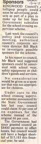
Newspaper, Scrapbook Clipping, Library Collection, Ringwood, Victoria, `
``Newspaper clipping from "The Mail", 13-4-93, P 14. Sponsors Ringwood Council's lollipop people could soon be advertising products as part of a plan to make up for lost State Government subsidies for the school crossing supervisor scheme. Council's corporate services director, Bill Black, is investigating possible sponsors for the scheme. Mr Black sugggested that sponsors could be associated with school wear, safety equipment or children's goods and services. No consideration would be given to a sponsor that was not appropriate for children. ` -
 Ringwood and District Historical Society
Map - Ringwood Animal Welfare Clinic, 1958 Land Survey Drawing, Ringwood, Victoria
Plan of driveway and property east of Heatherdale Road and Canterbury Road corner, with details of house, shed, bungalow, dog pen, kennels and enclosures.Survey by H.L.M. 31-7-58. Scale 20'=1" -
 Ringwood and District Historical Society
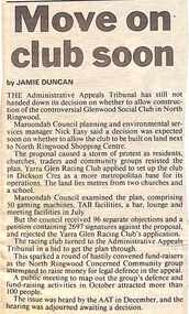
Newspaper, Scrapbook Clipping, Library Collection, Ringwood, Victoria, `
``Newspaper clipping from "The Mail", 21-1-97, P11, Move on club soon. By Jamie Duncan The Administrative Appeals Tribunal has still not handed down its decision on whether to allow construction of the controversial Glenwood Social Club in North Ringwood. The proposal caused a storm of protest as residents, churches, traders and commumnity groups resisted the plan.` -
 Ringwood and District Historical Society
Plan - Proposed Ringwood East Railway Station, VR Ringwood-Croydon (Dublin Road) - 1923
... Ringwood-Croydon (Dublin Road) - 1923 Plan Proposed Ringwood East ...Technical drawing of "Proposed Station At 16Mls 38Chs 89Lks (Dublin Road)" inluding boundary line, red shaded platform with station buildings, and green shaded possible future "up" track. Surrounding streets include Dublin Road, Patterson Street, and subsequent hand-written additions of Railway Avenue, Lawrence Grove, Stanley Avenue, Wenwood Street, and Lois Street. Land title details of Patterson Street properties mainly illegible.Scale: 40'=1". Possible future (platform) extension for 8 car trains (and) extension for 10 car trains. -
 Ringwood and District Historical Society
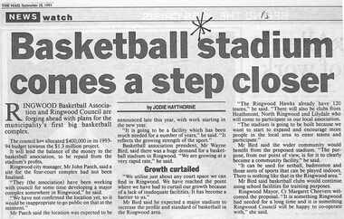
Newspaper, Scrapbook Clipping, Library Collection, Ringwood, Victoria, `
``Newspaper clipping from "The Mail" 28-9-93, P 3. NEWS watch. "Basketball stadium comes a step closer" by Jodie Haythorne Ringwood Basketball Association and Ringwood Council are forging ahead with plans for the municipality's first big basketball complex. The council has allocated $400,000 in its 1993-1994 budget towards the $1.3 million project.` -
 Ringwood and District Historical Society
Newspaper, Scrapbook Clipping, Library Collection, Ringwood, Victoria, `
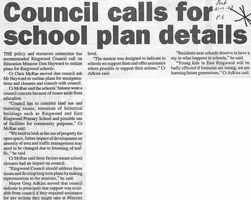
``Newspaper clipping from "The Post", 21-7-93, P 3. NEWS Watch - Council calls for school plan details The policy and resources committee has recommended Ringwood Council call on Education Minister Don Hayward to outline plans for Ringwood schools. Councillor Chris McRae moved that council ask Mr Hayward to outline plans for amalgamations and closures and consult with council.` -
 Ringwood and District Historical Society
Map - Public Land Sale by Thomas Ham, 2000 Acres for Sale - Crown Sections 20, 23, 24 - Ringwood, Victoria - 1855
Two 1850s surveyor's maps on cardboard backing showing area from Melbourne extending East beyond Bulleen and Nunawading. Detailed description of lots for sale and navigational directions to the property from Richmond by Thomas Ham, Victorian public servant, map maker, publisher, lithographer and original Ringwood land owner. Inset map enlarging area between Yarra River and Dandenong Creek, with southern boundary of allotments later forming part of Oban Road, North Ringwood.TRANSCRIPT: "This really valuable Property is now offered to the public for sale, in lots to suit purchasers at the Iow rate of £1 per Acre for 80 acres and upwards, and £1.10s per Acre for any smaller portion. Terms of payment Half Cash, Balance in 6 and 12 months, bearing 8 per cent interest. The Estate is well wooded with Gum, Cherry Tree and Stringy Bark, with Wattle in the valleys of the several creeks. Every lot is Staked and Trenched at the corners marked on the Plan thus - The Surveyor has carefully sub-divided the Property, in order to give every Farm a Creek for Water, Valley for Cultivation, and Hills for House and Grass Paddock. The ROADS have been very carefully laid out so as to give a firm, well drained, and nearly level road to each Homestead. Intending purchasers can readily find the property by the following directions, viz: Start from Richmond Bridge, at Hawthorne, then take the left-hand road to KEW. When at the "Woodman Inn", take the Cotham Road to the right, bearing due east, keep this Road, passing Trainor's "White Horse" Inn, and before you leave the fences, you will see calico bills (see margin) nailed to the Trees on the bush track leading to the Upper Yarra country, follow the Bills till you come to the SOUTH boundary line of the Property, which bears East and West (see Plan) where you will see Bills nailed up "THIS PROPERTY FOR SALE, etc." The Bills from Town lead direct to where Mr. Jull is erecting his Store, and arrangements have been made with him to show the lots to intending purchasers free of charge. At the respective corners of the lots the Bills are nailed up double, with numbers to denote the lot, and that the corner stake is adjacent. Any parties wishing to proceed to the property by way of BULLEEN will find Bills nailed on the Trees, commencing at the NEW INN, at "Wilson's Slip Rail." Keep this Track till you come to the Log Bridge, over the Deep Creek at Bloxhome's Paddock; go through the land now being cleared; keep the track over the hill till you come to an Iron House, you will then be on the property, which Iies to the North and East as per Plan. Follow the Bills till you come to Mr. Jull's Store, etc. etc. Further particulars can be had from the Agent for the Property. THOMAS HAM. " -
 Ringwood and District Historical Society
Newspaper, Scrapbook Clipping, Library Collection, Ringwood, Victoria
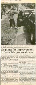
Newspaper Clipping from the ""Mail", 5 May 1998 P20. "No plans for improvement to Oban Rd's poor condition"Ringwood North residents say they are fed up with speeding traffic, "dangerous" gravel edges and deep potholes on Oban Road. Ringwood North Primary School Principal Barry Archibald said there was a great deal of concern within the school community about the condition of the road. A council spokesman said no works were planned for the unsealed section of Oban Road because "council only had a certain amount of money for grading" He said no roadworks were planned near the school either. -
 Ringwood and District Historical Society
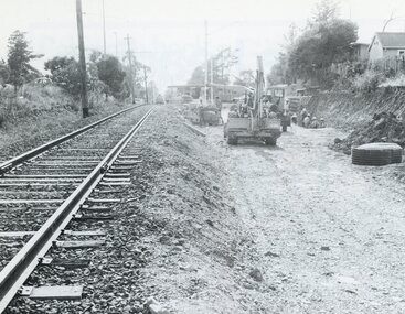
Photograph, Duplication of the five-kilometre section of railway line between Ringwood and Croydon in 1983
Digital scanFrom Vicrail News magazine, April 1983. “Duplication of the five-kilometre section of line between Ringwood and Croydon is on the way. Several major works will be undertaken over the next few months so the two tracks can be brought into service later this year. Intensive work on this section follows completion of duplication works between Ringwood and Bayswater on the Belgrave line last December. The completion of this 5.17 kilometre section between Ringwood and Bayswater means that this Belgrave line is now duplicated as far out as Ferntree Gully. Commuters using the Belgrave line now have an improved service with the intro duction in January of an additional evening peak train to Upper Ferntree Gully, two additional peak hour services in the morning from both Belgrave and Upper Ferntree Gully, and with the additional tracks delays on one line will not affect trains travelling in the opposite direction. Commenting on the completion of this stretch of track the Minister of Transport, Mr. Crabb, said a further improvement had been made with the commissioning of boom barriers at the Bedford Road level crossing in Ringwood. "The installation is part of the State Government's $9.4 million four-year plan to equip 70 dangerous level crossings throughout the State with boom barriers", he said. Works to be carried out on the Ringwood/ Croydon section include laying of new track, station works at Croydon and installation of boom barriers at East Ringwood. Already completed are bridge works to cater for double tracks at both Mt. Dandenong and Eastfield Roads between Croydon and East Ringwood and construction of an island platform at East Ringwood station. At several locations alignment of the existing track will be slightly relocated. The new line is being constructed with concrete sleepers and heavyweight rails. The existing line will also be reconstructed using these heavy 60kg per metre rails. Engineering works to be completed include installation of overhead wiring necessary to supply power to trains, construction of two new station buildings and a new platform at Croydon, provision of boom barriers, and pedestrian boom barriers at Dublin Road level crossing. East Ringwood, and replacement of existing timber overhead wire support structures with steel structures. Other works in this program included installation of boom barriers at Bedford Road, Ringwood and Scoresby Road, Bayswater and provision of a new platform for trains going to Melbourne and Heathmont. A new timetable on the Lilydale and Belgrave lines will commence when the Ringwood—Croydon duplication track work is completed.” -
 Ringwood and District Historical Society
Document - Folder, Commercial and Retail Property Sales Information, Civic Place and Melbourne Street, Ringwood - 1998
45 photocopied pages including - Plan of Subdivision No.LP80718, Parish of Ringwood, Victoria, Crown Portion 12(Part) and part of a former government road Ref Vol 8668 Fol 745. - Vendors Statement, Planning Certificate and Heritage Council (Victoria) Certificate issued for 20 Melbourne Street, Ringwood. - Maroondah City Council Land Information Certificate for 149 149A and 149B Maroondah Highway; number 8 Civic Mall; and numbers 16, 20, 22 & 24 Melbourne Street Mall. - Yarra Valley Water statements relating to encumbrances for Shop 11, 149 Maroondah Highway; Shop 10, 149A Maroondah Highway; Shop 9, 149B Maroondah Highway; numer 8 Civic Place; Unit 3, 20 Melbourne Street; Office 4, 20 Melbourne Street; Shop 7, 22 Melbourne Street; and Shop 8, 24 Melbourne Street. - Land Tax Certificate pertaining to Commonwealth Bank, Civic Place, Ringwood. - Certificate of Title Vol 8892 Fol 906, Lot One on Plan of Subdivision No. 80718, Parish of Ringwood - Hanover Developments P/L - 29th June, 1971. -
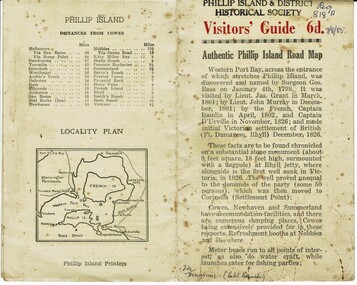 Phillip Island and District Historical Society Inc.
Booklet, Authentic Phillip Island Road Map, Pre 1960
Tourist brochure printed by the Phillip Island Printers pre 1960HistoricalSmall cream coloured brochure with details of accommodation, transport and animals. Inside is a map of the Island with numbered points of interest. There is also a plan of Cowes and drawings of animals.Visitors' Guide 6d Authentic Phillip Island Road Maptourist brochure, road map -
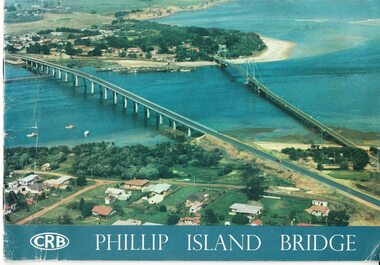 Phillip Island and District Historical Society Inc.
Booklet, Official Opening of the Phillip Island Bridge at San Remo 1969 and notes by the Bridge engineer, Tom Russell, 1969
Prior to 1939 access to the Island was by punt from San Remo or car ferry from Stony Point. A bridge was opened in 1940 but increased traffic and low load capacity was a problem. The decision to build a new bridge was made in the 1960s.HistoricalColoured, bound booklet with a photo of the old and new Phillip Island bridges on the cover and the CRB logo and name on rear. It includes the order of proceedings for the opening and bridge statistics, plans and contractor information. Also photos of construction and a history of travel to the Island before a bridge was built and the first bridge. There is also a 2 page typed document written by the bridge engineer who gives a brief history of access to the Island and problems at the opening with access and a rebel who tried to open it unofficially.Official Opening of the Phillip Island Bridge at San Remo by The Hon. M.V. Porter, MLA. Minister of Public Works. November 21 1969bridges, 2nd phillip island bridge construction, tom russell, phillip island bridge opening 1969 -
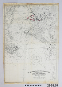 Flagstaff Hill Maritime Museum and Village
Document - Navigation Chart, The Melbourne Harbor Trust Commissioners
Navigation Chart - The Melbourne Harbor Trust Commissioners - General Plan - Shewing proposed Harbor Improvements. Hobson's Bay and Citywarrnambool, shipwrecked-coast, flagstaff-hill, flagstaff-hill-maritime-museum, maritime-museum, shipwreck-coast, flagstaff-hill-maritime-village, shipwrecked-artefact, navigation chart, hobson's bay, the melbourne harbor trust -
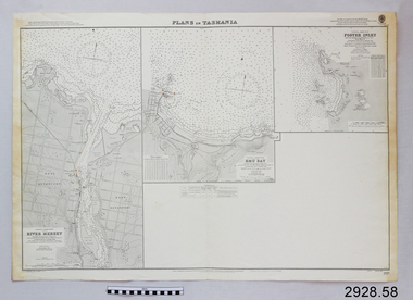 Flagstaff Hill Maritime Museum and Village
Document - Navigation Chart, Plans in Tasmania - Foster Inlet, River Mersey and Emu Bay
Navigation Chart - Plans in Tasmania - Foster Inlet, River Mersey and Emu Baywarrnambool, shipwrecked-coast, flagstaff-hill, flagstaff-hill-maritime-museum, maritime-museum, shipwreck-coast, flagstaff-hill-maritime-village, shipwrecked-artefact, river mersey, foster inlet, emu bay, navigation chart -
 Ringwood and District Historical Society
Plans - Freeway, Country Roads Board, Victoria, Eastern Freeway Ringwood Section - Planning Report on Suggested Concepts Investigation (Country Roads Board) 1974, 1974
... - Planning Report on Suggested Concepts Investigation (Country Roads ...Report on suggested concepts investigation for freeway.Report on suggested concepts investigation for freeway. Buff coloured covers with brown printing. Bound with brown Spirex. pp. 39. -
Ringwood and District Historical Society
Pamphlet, Ringwood Area pamphlets and promotional material. 2006, 2006
They include Maroondah Police Seniors Register, The Kerrabee Club Planned Activity Group, Skate and BMX in Maroondah, Access 4 all 2 Play, Local Service Groups, Carolyn Gold Bug display (Maroondah Gallery); and maintaining Mobility in Ringwood.Collection of 8 pamphlets about activities in Ringwood.; They include Maroondah Police Seniors Register, The Kerrabee Club Planned Activity Group, Skate and BMX in Maroondah, Access 4 all 2 Play, Local Service Groups, Carolyn Gold Bug display (Maroondah Gallery); and maintaining Mobility in Ringwood. -
Ringwood and District Historical Society
Brochure, Farros Falcon Press, Heathmont Station Estate Pamphlet incl sub division plan (undated0, Not Known
Promotional brochure from estate agents H. C. Costello & Co Auctioneers for the Heathmont Station Estate: 140 beautiful home sites.Large buff coloured bifold pamphlet advertising Heathmont Station Estate. Red and black printing; photo on front and back; subdivision plan inside. +Additional Keywords: Costello, H. C. & Co. -
Ringwood and District Historical Society
Papers - Miscellaneous, City of Ringwood Jubilee 1974. Bundle of papers. C1974, c. 1974
Miscellaneous papers of the planning process for the jubilee celebration in 1974 when Ringwood became a City.City of Ringwood Jubilee 1974. Bundle of papers: mostly foolscap in cream manila folder.City of Ringwood Jubilee 1974 -
Ringwood and District Historical Society
Capsule List, List of items in Maroondah Time Capsule. (undated), Unknown
List of local publications, plans, programmes, currency, maps etc., identified with the Maroondah area.List of items in Maroondah Time Capsule. Pale lemon coloured A4 page -
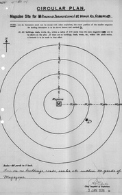 Ringwood and District Historical Society
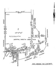
Plan of magazine site, Mines Dept, Explosives Magazine Licence and Maps, Wonga Rd Ringwood. 1940, 1936, 1938-1940
... Road Ringwood North melbourne Plans for the magazine site ...Plans for the magazine site in Ringwood, located at Wonga Road, Ringwood. Magazine licence 2 pages. Area map showing Warrandyte, Ringwood and Deep Creek. -
Ringwood and District Historical Society
Newsletter, Enjoying Planned Retirement Newsletters June 2010, Jun-10
EPR was incorporated in December 20027 A4 pages printed double sided - News of EPR Inc Newsletter - June 2010 - Enjoying Planned Retirement +Additional Keywords: EPR / Enjoying Planned Retirement -
Ringwood and District Historical Society
Pamphlets, N.R. Reid & Co Pty Ltd, Subdivision pamphlet Hunter Estate Ringwood, 1959
The Hunter Estate, from Wonga Road to Mullum Mullum Road including Panfield Avenue, Hunter Avenue and Hendra Grove.Bifold pamphlet green black and white printing, plan of subdivision on second page -
Ringwood and District Historical Society
Plan, SGL Consulting Group Aust Pty, Maroondah Leisure Facilities Review / Strategic Plan 2010-2050, May-10
Prepared for the Maroondah City Council, Vol one - Executive Summary of the Maroondah Leisure Facilities Review Strategic Management Plan 2010-20508 A4 double sided printed documents with black and white photos, charts & text -
Ringwood and District Historical Society
Land titles and plan, Victorian Titles Office, Titles and plans of Ringwood Land between Mullum Land and Wonga Rd. (Re Ann Jane Kennedy). 1907, 1-Oct-07
The documents pertaining to Ann Jane Kennedy inheriting the land from her late husband Samuel John Kennedy and the history of the transfers of land from Ann Jane Kennedy in 1907 until the title was cancelled in 1925 to James Melbourne Ross. The area was 10 acres between Mullum Mullum Road and Wonga Road retrieved from Titles Office.Ten pages of photocopied titles and plans of land in Ringwood between Mullum Road and Wonga Road, also transfer of original land. -
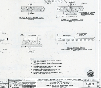 Ringwood and District Historical Society
Plan - plans, Metropolitan board of Works, Metropolitan Board of Works plans of North Ringwood retarding basin, energy dissipaters and spillway details, 1979, 31-May-79
... Road Ringwood North melbourne Plans made by the Metropolitan ...Plans made by the Metropolitan Board of Works in May 1979 detailing 1. energy dissipaters for existing drains at the North Ringwood Retarding basin. 2 spillway details2 A3 pages with drawings of Melbourne Metropolitan Board of Works of the North Ringwood retarding basin -
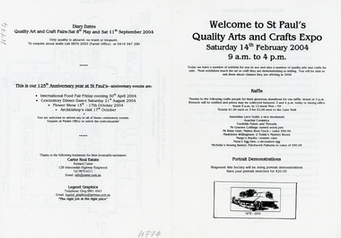 Ringwood and District Historical Society
Pamphlet, St. Paul's Quality Arts and Crafts Expo - Ringwood - 2004, 14-Feb-04
Quality Arts and Crafts Expo part of the celebrations at St. Paul's Church, Ringwood on the 125th. Anniversary of the Church. Other events were International Food Fair, April, Celebratory Dinner Dance August, Flower Show October, and Archbishops Visit October.Black and white A4 bifold pamphlet with black printing and B&W sketch of Church on lower front. Plan of stalls on p3. Printing on all pages +Additional Keywords: Carter, Richard -
Ringwood and District Historical Society
Collection of papers, Documents pertaining to the planning and implementation the Ringwood Methodist Day Kindergarten
Property of Ringwood Methodist Pre-School CouncilDocuments pertaining to the planning and implementation the Ringwood Methodist Day Kindergarten.They include 47 pages of advertisements, letters,draft constitution. All in a manila folder. +Additional Keywords: Bandt, Rev R MProperty of Ringwood Methodist Pre-School Council -
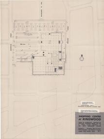 Ringwood and District Historical Society
Plan, Myer Emporium Limited, Planning Application by Eastland Shopping Centre Pty Ltd - Ringwood Planning Scheme 1960. 2 Plans, 1960
One of the plans referred to in the application by Eastland Shopping Centre, a wholly owned subsidiary of the Myer Emporium Limited.|Upper floor plan and lower level traffic plan. Application No 3, Ringwood Planning Scheme 1960.|Architects: Tompkins, Shaw & Evans|Traffic Engineers: Len T Frazer and AssociatesTwo copies of plans for the Ringwood Shopping Centre, comprising; 1. Upper floor plan; 2. Lower level traffic level; Buff coloured heavy paper with black printing. Application No 3, Ringwood Planning Scheme. Shopping Centre at Ringwood design for developmetn submitted by EASTLAND SHOPPING CENTRE PTY.LTD a wholly owned subsidiary of THE MYER EMPORIUM LIMITED Architects: Tomkins, Shaw and Evans Taffic Engineers: Len T. Frazer & Assocs -
 Ringwood and District Historical Society
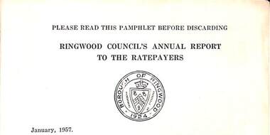
Pamphlet, Council of Borough of Ringwood - Alfred Kelly, Town Clerk and Treasurer, Ringwood Council's Annual Report To The Ratepayers (January 1957), 1957
Report dated January, 1957, setting out Borough of Ringwood functions and implementation plans.rinx