Showing 575 items matching "route map"
-
 Ballarat Tramway Museum
Slide - 35mm slide/s - set of 2, Peter Moses, Aug. 1971
... routes. .2 - the whole map. Kodak cardboard mount slide, taken... on the tram routes. .2 - the whole map. Kodak cardboard mount slide ...Set of two photographs of a map of Ballarat showing the tramway routes that have been published by the Greater Ballarat Association. .1 - close up view of the map, focusing on the tram routes. .2 - the whole map. Kodak cardboard mount slide, taken by Peter Moses, August 1971. See Reg Item 5613 for an actual copy of this map, though in poor condition. Also Reg Item 2776 for another version.On the rear of the slides in red ink. .1 - "Ballarat / Tram routes" .2 - Ballarat / Tram routes" and words "very good".tramways, trams, ballarat, map, greater ballarat association -
 Melbourne Tram Museum
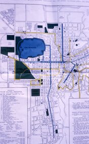
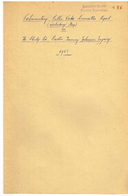
Document - Report, Parliamentary Public Works Committee, "Parliamentary Public Works Committee Report Plenty Road, Preston, Tramway Extension Enquiry, 1967
... Preston route to Bolderwood Parade. Map shows extension proposed... Preston route to Bolderwood Parade. Map shows extension proposed ...Report contained within a light brown card folder, containing a photocopy of report titled "Parliamentary Public Works Committee Report (including map) on The Plenty Road, Preston, Tramway Extension Enquiry - 1967". Report stapled in top right hand corner, 15 pages examining the extension of the East Preston route to Bolderwood Parade. Map shows extension proposed, bus routes, railway lines, streets - folded into 4.AETA stamp on front and inside sheet and "4E6" in ink on front cover. AETA stamp on the bottom right hand corner of the map.trams, tramways, east preston, new tramway, bolderwood parade, proposals -
 Melbourne Tram Museum
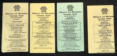
Ephemera - Timetables - MMTB trams - set of 7, Melbourne & Metropolitan Tramways Board (MMTB), 1972
... , timing points, with a description of the route and a map. 1..., with a description of the route and a map. 1 - West Preston - Northcote ...Timetables - provide information on ticketing, fares, timing points, with a description of the route and a map. 1 - West Preston - Northcote - City - routes 9, 10, 11 - Feb. 1972 2 - North Coburg with connecting bus to Fawkner and Gowrie - Upfield on Sundays route 19, 20 and 18 - March 1972 3 - North Balwyn Burwood - City - routes 48, 40, 41, 37, 74, 75, 76, 28 - Feb. 1972 4 - West Coburg - Domain Road and West Coburg City on Sundays - routes 55, 56 and 68 - March 1972 5 - West Maribyrnong - City - (bus routes on Sunday only) - routes 57, 54, 60, 58 and 50 - Feb. 1972 6 - Essendon Aerodrome - City - route 49, 49, 52 and 51 - March 1972 7 - Footscray - Moonee Ponds - bus route on Saturday afternoons and Sundays - route 82 Feb. 1972Yields information about MMTB tram services during 1972Set of seven MMTB tram timetables - multifolded printed on yellow or green paper.timetable, mmtb, route 10, route 9, route 11, route 19, route 18, route 20, route 48, route 40, route 41, route 37, route 74, route 75, route 76, route 28, route 55, route 56, route 68, route 57, route 54, route 60, route 58, route 50, route 59, route 49, route 52, route 51, route 82 -
 Melbourne Tram Museum
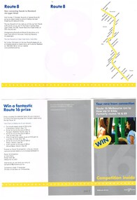
Pamphlet, Yarra Trams, "Your new tram connection - Route 8 Moreland to Toorak - via Lygon St - Formerly routes 8 and 22", Oct. 2004
... of the two routes. Includes a map and that a competition was being... of the two routes. Includes a map and that a competition was being ....1 - Pamphlet - 3 fold DL size, full colour titled "Your new tram connection - Route 8 Moreland to Toorak - via Lygon St - Formerly routes 8 and 22", about the amalgamation of the two routes. Includes a map and that a competition was being run to complete a statement. .2 - ditto - "Your new tram connection - Route 16 - Melbourne Uni to Kew - Formerly routes 16 and 69" Pamphlet gives date of change as Sunday 17 Oct, but no year. Yarra trams route number history web page gives it as 2004 - http://www.yarratrams.com.au/media/43839/tramroutenumbers.pdf - access 25-10-2015 Two copies held.trams, tramways, yarra trams, route 8, toorak, moreland, route 16, route 69, kew -
 Ballarat Tramway Museum
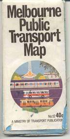
Map, Ministry of Transport, "Melbourne Public Transport Map" - "No. 12", 1982
... . On the rear, route numbers and line maps of tram routes and train... numbers and line maps of tram routes and train lines or services ...Pocket size - folded - public transport map of Melbourne, printed in colour on paper, showing public transport services in greater Melbourne, including ticketing information, travelcards and an index of localities. The Central zone area shown in detail. On the rear, route numbers and line maps of tram routes and train lines or services and fare zones. The first map with the new three zone system of fares. Includes private bus routes. Printed 1982 by Government Printer. Issue No. 12.On inside, a circle route around Flinders, Queen, Little Collins and Swanston St in blue felt pen and arrow in blue ink. On the rear, a sketch map showing the location Charles St, Mantell St and William Road, and a circle around Upfield station.trams, tramways, melbourne, map, routes -
 Melbourne Tram Museum
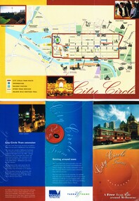
Pamphlet, Dept of Planning and Development, "Catch the City Circle", 1994
... - has the original route by Spencer St - map shows various...", detailing the City Circle tram, 1994 - has the original route ...Pamphlet - DL 6 fold from A3 sheet, full colour titled "Catch the City Circle", detailing the City Circle tram, 1994 - has the original route by Spencer St - map shows various points and details the various locations.. Has contact details but no web site. Has the Victoria government, Better Cities and Public Transport Corporation Logos. See Reg Item 866, 2703 and 1337 for other versions. Second copy added 24-04-2019 from Bob Prentice Collection.trams, tramways, city circle, yarra trams, ptc -
 Melbourne Tram Museum
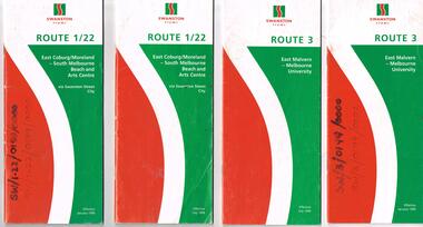
Ephemera - Timetable, Swanston Trams, Set of Swanston Trams timetables, 1999
... and route map. Has a fold out with a feed back form. .1 - Route... and route map. Has a fold out with a feed back form. .1 - Route 1 ...Set of Swanston Trams timetables, red white green cover with route number on cover, giving details of popular destination, check points, use of Metcards and contact details, tram hire, frequency, a Welcome to Swanston Trams, description of route and route map. Has a fold out with a feed back form. .1 - Route 1/22 - East Coburg / Moreland - South Melbourne Beach and Arts Centre - January 1999 - 40 pages. .2 - ditto - July 1999. .3 - Route 3 - East Malvern - University - July 1999 - 28 pages .4 - ditto - January 1999 .5 - Route 5 - Malvern (Burke Rd) - University - July 1999 - 24 pages .6 - Route 6 - Glen Iris - City - January 1999 - 28 pages .7 - ditto - July 1999. .8 - Route 8 - Toorak - January 1999 - 32 pages .9 - ditto July 1999 .10 - Route 16 - St Kilda Beach - University - January 1999 - 28 pages .11 - ditto July 1999 .12 - Route 19 - North Coburg - City - January 1999 - 48 pages .13 - ditto July 1999 .14 - Route 55 - West Coburg - Domain Interchanges via William St - January 1999 - 32 pages .15 - ditto July 1999 .16 - Route 57 - West Maribyrnong - City - January 1999 .17 - ditto July 1999 .18 - Route 59 - Airport West - City - June 1999 .19 - Route 64 - East Brighton - University - January 1999 - 28 pages .20 - ditto July 1999 .21 - Route 67 - Carnegie - City - January 1999 - 28 pages .22 - ditto July 1999 .23 - Route 69 - Kew Cotham Rd - St Kilda Beach - January 1999 - 28 pages .24 - ditto July 1999 .25 - Route 72 - Camberwell - University - January 1999 - 28 pages .26 - ditto July 1999 .27 - Route 78/79 - North Richmond - Prahran or St Kilda Beach - January 1999 - 28 pages .28 - ditto July 1999 .29 - Route 82 - Moonee Ponds - Footscray - January 1999 - 20 pages .30 - ditto July 1999Some have number notes and notes written inside about changes or errors in ink. See History.trams, tramways, swanston trams, tram services, timetables, route 1, route 22, route 3, route 5, route 6, route 8, route 16, route 19, route 55, route 57, route 59, route 64, route 67, route 69, route 72, route 78, route 79, route 82 -
 Melbourne Tram Museum
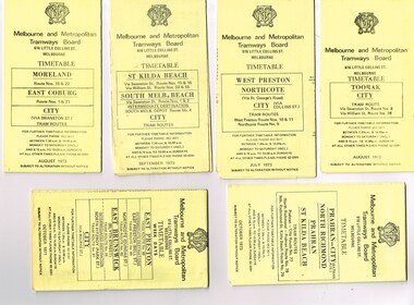
Ephemera - Timetable/s, Melbourne & Metropolitan Tramways Board (MMTB), "MMTB Tram Timetables", 1971 and 1973
... sections, providing timetables for specific routes, day of week... at specific time points, route map, sections and fares ...Set of 20 MMTB Tram timetables, folded sheets, generally 10 sections, providing timetables for specific routes, day of week giving information on tram times at specific time points, route map, sections and fares and organisation address - 616 Little Collins St. Melbourne. All printed on yellow paper unless noted otherwise. .1 - Route 8 and 38, Toorak - City - August 1973 .2 - Route 9, 10 and 11, West Preston, Northcote - City - July 1973 .3 - Route - 1, 2, 4, 15, 16, 53, 55 - St Kilda Beach, south Melbourne Beach - City - September 1973 .4 - Route 1, 21, 15, 22 - Moreland, East Coburg - City - August 1973 .5 - Route 77, 78, 79 - Prahran - City, North Richmond, St Kilda Beach - October 1973 .6 - Route 88, 89, 90, 97 - East Preston, East Brunswick - City - October 1971 .7 - ditto - printed on green paper for Saturdays and Sundays. .8 - Route 59 - Essendon - City - June 1961 .9 - Route 8 - Toorak - City - Oct 1961, printed on yellow paper .10 - Routes 48, 40, 41, 37 and 74, 75, 76, 28 - North Balwyn or Burwood to City - March 1972 lists all the short routes by name and printed on yellow paper. .11 - Route 55, 56 and 68 - West Coburg - City or Domain Road - March 1972 - printed on yellow paper. .12 - Routes 48, 24, 40, 41, 29, 74, 75, 76 and 28 - North Balwyn or Burwood to City - March 1976 - printed on yellow paper. .13 - as for .12, Saturdays and Sundays - printed on green paper, ,14. - Route 19, 20 and 18 - Coburg - March 1972 - includes connecting bus to Upfield ,15 - Routes 1, 21, 15 and 22 - Moreland and East Coburg - March 1972 .16 - Routes 64, 65, 62 and 61 - East Brighton - June 1973 .17 - Route 3 - East Malvern - June 1973 ,18 - Route 5, 35 - June 1973 .19 - Route 82 - Footscray - Moonee Ponds - Oct. 1974 - bus Saturday afternoons and Sundays .20 - Route 67, 37 and 66 - Carnegie - June 1973trams, tramways, mmtb, timetables, melbourne, upfield, fares, route 1, route 2, route 3, route 4, route 5, route 8, route 9, route 10, route 11, route 15, route 16, route 18, route 19, route 20, route 21, route 22, route 38, route 35, route 37, route 53, route 55, route 66, route 67, route 77, route 78, route 79, route 88, route 89, route 90, route 96, route 97, route 59, route 48, route 40, route 41, route 37, route 74, route 75, route 76, route 82, route 28, route 55, route 56, route 68, route 29, route 24 -
 Melbourne Tram Museum
Ephemera - Timetables - MMTB trams - set of 8, Melbourne & Metropolitan Tramways Board (MMTB), 1976
... , and timing points, with a description of the route and a map. Not all... points, with a description of the route and a map. Not all ...Timetables - provide information on ticketing, fares, and timing points, with a description of the route and a map. Not all services had been allocated a route number at the time. 1 - East Brighton - City and via William St - routes 64, 65, 62 and 61 - July 1976 2 - Malvern (Burke Rd) to City and via Wiliam St - routes 5 and 35 - Oct. 1976 3 - Carnegie - City and via William St - routes 67, 37, and 66 - July 1976 4 - Wattle Parke - City and Camberwell depot - routes 70, 71 and 76 - Sept. 1976 5 - Kew - Cotham Road to St Kilda Beach - route 69 - August 1976 6 - East Preston - via Bourke or La Trobe, and East Brunswick - routes 88, 14, 89. 90, 96, 95, and 97 - Feb. 1976 7 - Toorak - City and via William St - routes 8 and 38 - August 1976 8 - St Kilda Beach and South Melbourne Beach and via William St - routes 15, 16, 53, 55, 1, 2 and 4 - Sept. 1976 Yields information about MMTB tram services during the 1970s. Set of 8 MMTB tram timetables - multifolded printed on yellow paper.timetable, mmtb, wattle park, east brighton, malvern, carnegie, kew, east brunswick, toorak, st kilda beach, south melbourne beach, route 64, route 65, route 62, route 61, roure 5, route 35, route 67, route 37, route 66, route 70, route 71, route 76, route 69, route 88, route 96, route 8, route 38, route 15, route 1, route 2, route 55, route 53 -
 Melbourne Tram Museum
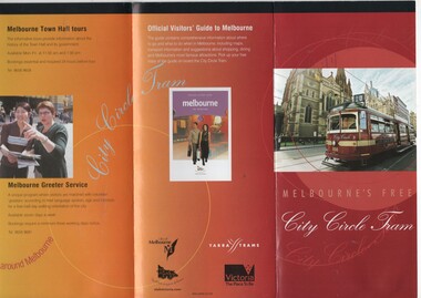
Pamphlet, Department of Infrastructure (DOI), "Melbourne's Free City Circle Tram", 2005
... to Melbourne". Details the City Circle tram, c2005 - has route via... - has route via Harbour Esplanade - map shows various points ...Pamphlet - folded to DL size, 8 fold, titled "Melbourne's Free City Circle Tram" and on rear "Official Visitors Guide to Melbourne". Details the City Circle tram, c2005 - has route via Harbour Esplanade - map shows various points, the Golden Mile heritage walk. Has the Victoria government, City of Melbourne and Yarra Trams logos. Provides information on the points of interest and the Visitor Centre. Gives a short history of Melbourne's tram and has a photo of V214 See Reg Items 1199, 866 and 2993 for other versions.trams, tramways, city circle, yarra trams, docklands, tram 856, tram 888, tram 214, tram 3004 -
 Melbourne Tram Museum
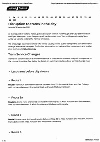
Ephemera - Timetable, Public Transport Victoria (PTV), "Disruption to trams in the City", 17/09/2021 12:00:00 AM
... changes route by route and a map. .2 - set of 6 sheets from... changes route by route and a map. .2 - set of 6 sheets from ...Set of four documents associated with a planned major Demonstration over COVID-19 lockdowns planned to be held in the city on Saturday 18/9/2021. The actual event took place outside Richmond Town Hall and then in Barkers Road Hawthorn. News stories of the night did show some trams were caught up in the event. .1 - set of 5 pages printed from the Yarra Trams website showing changes route by route and a map. .2 - set of 6 sheets from the PTV website including Metro Trains and regional services. Note many VLine crews were impacted by a COVID outbreak and were isolating. .3 - Yarra Trams Employee Notice Y21653 - digital image copy only .4 - Map of the event - digital image.trams, tramways, covid-19, timetables, tram services, events -
 Melbourne Tram Museum
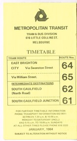
Ephemera - Timetable, Metropolitan Transit Authority (MTA), "Metropolitan Transit Timetables", Jan. 1984
... time points, route map, sections and fares and Transport... at specific time points, route map, sections and fares and Transport ...Set of 13 Metropolitan Transit Tram timetables, folded sheets, 8 to 10 sections, providing timetables for specific routes, day of week giving information on tram times at specific time points, route map, sections and fares and Transport Information Centre telephone number. All printed on yellow paper. .1 - Route 64 (65 via William St), 62 and 61 - dated January 1984. .2 - Route 3 (Darling Road via Swanston St) with route 377 bus on Sundays via Batman Ave. - July 1984 .3 - Route 5 - Malvern Burke Road - City - July 1984. Cover was printed showing route 35 via William St, but has been crossed out in pencil. .4 - Route 6 (Glen Iris - City) and Route 7 (Malvern Town Hall) - July 1984. Cover was printed showing route 36 via William St, but has been crossed out in pencil. .5 - Route 8 - Toorak - City - June 1984. Cover was printed showing route 38 via William St, but has been crossed out in pencil. .6 - Route 10 and 11 West Preston via Collins St and Route 13 via Latrobe St - March 1985. .7 - Route 10 and 12 - South Melbourne and St Kilda Beach - City (Brunswick St) via Collins St and route 17 - Park and Clarendon Sts. - Sept 1984 .8 - Route 15 and 22 - Moreland to City, July 1983 .9 - Route 15, 16 and 55 - St Kilda Beach to City via Swanston St - July 1983. Cover was printed showing route 53 via William St, but has been crossed out in pencil. .10 - Route 19 (Coburg), 18 (Brunswick) and 20 (Bell St) - City - August 1984 .11 - Routes 59 (Airport West), 49 (Niddrie), 52 (Bulla Road), 51 (Essendon Station) and 81 (Essendon Depot) - April 1985. .12 - Route 69 - Kew Cotham Road to St Kilda Beach - Sept. 1984 .13 - Route 72 (Camberwell - City), 32 via William St and route 73 (Camberwell Junction) - August 1984. .14 - Route 1 and 21 - East Coburg - City - August 1983. Full Image of .10 added 9/4/17 following a query about route 19 timetables - see image i6trams, tramways, the met, timetables, melbourne, latrobe st, la trobe st, mta, buses, route 64, route 65, route 3, route 5, route 6, route 8, route 10, route 11, route 12, route 13, route 17, route 15, route 22, route 16, route 55, route 19, route 18, route 20, route 59, route 49, route 52, route 51, route 81, route 69, route 72, route 32, route 73, route 1, route 21 -
 Melbourne Tram Museum
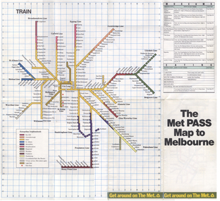
Map, The Met, "The Met PASS Map to Melbourne", c1988/90
... Folded Map of Melbourne Rail and Tram lines, titled.... Opened November 1987. Rail Map - shows Route 96 north section ...Folded Map of Melbourne Rail and Tram lines, titled "The Met PASS Map to Melbourne" Tram Map - probably soon after conversion of the St Kilda and Port Melbourne lines to Light Rail, though these are not shown. Opened November 1987. Rail Map - shows Route 96 north section as Light Rail, co-ordinated bus routes, and the Altona line as going to Werribee. This route was opened in 1985. Date of Map c1988/1990. Has details of Museums, Art Galleries, Shopping, Gardens and Sports Arenas. See also Reg Item 379 for a similar item.trams, tramways, the met, melbourne, maps, tourist tickets -
 Bendigo Historical Society Inc.
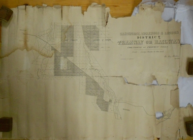
Map - MARKS COLLECTION: TRAMWAY OR RAILWAY MAP SANDHURST
... LH corner, Inglewood. Map shows route of railway line from... railway reserve. Top LH corner, Inglewood. Map shows route ...Original map of 'land granted as endowment' for tramway or railway. On top Rh corner of map, in bold print 'Sandhurst, Inglewood & Loddon district Tramway or Railway. Land granted as endowment shaded, scale 60 chains to 1 inch. Lithographed by J & W. Holmes, Lith. Sandhurst'. Signed by Geo Avery Fletcher, Engineer. Map shows Parish of Leichardt, Parish of Yarraberb, Parish of Bridgwater and a section of Marong. On bottom RH corner, is small map of Sandhurst, showing railway reserve. Top LH corner, Inglewood. Map shows route of railway line from Sandhurst to Inglewood.map, marks collection, railway, inglewood -
 Melbourne Tram Museum
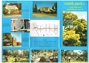
Pamphlet, Melbourne & Metropolitan Tramways Board (MMTB), "Wattle Park - a gold and green oasis", Mid to late 1970's
... , the Tramways band, buildings, the Lone Pine tree. On the rear is a map..., the Lone Pine tree. On the rear is a map showing route 70 ...Pamphlet, folded sheet, six folds, full colour on blue background gloss paper titled "Wattle Park - a gold and green oasis" giving information on the park, its history, management (MMTB) and sporting uses. Has a number of photos of sporting activities, the Tramways band, buildings, the Lone Pine tree. On the rear is a map showing route 70 and details of the tram timetable. In the bottom right hand corner of the pamphlet are the words "MTB Publication". No contact numbers or addresses given. Printed in the same style as Reg Item 594. Second copy added 19-1-2017 from donation of John PrideauxIn ink in top left hand corner "4J40" - AETA Library location.trams, tramways, wattle park, mmtb -
 Melbourne Tram Museum
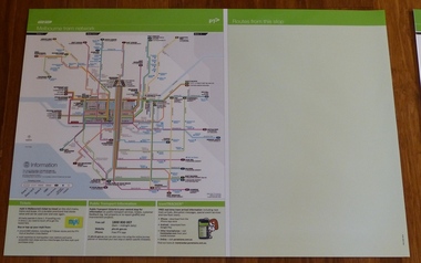
Poster, Yarra Trams, "Melbourne Tram Network" and "Routes from this stop", Dec. 2012
... "Routes from this stop" Map shown as effective April 2011... Trams tramways Yarra Trams PTV Maps TramTracker Myki Full colour ...Full colour poster printed on a vinyl plasticized based sheet, titled "Melbourne Tram Network" - showing a diagrammatic layout of Melbourne tram routes, Myki ticket notes and where tickets can be obtained, information numbers (PTV, phone applications) and information on Tram Tracker, twitter and other contact systems on the left side and a blank right side titled "Routes from this stop" Map shown as effective April 2011, and printed December. 2012. Has the document information on the right hand side of the poster. See Reg Item 628 for an example of how this base poster was used. Two copies held.trams, tramways, yarra trams, ptv, maps, tramtracker, myki -
 Melbourne Tram Museum
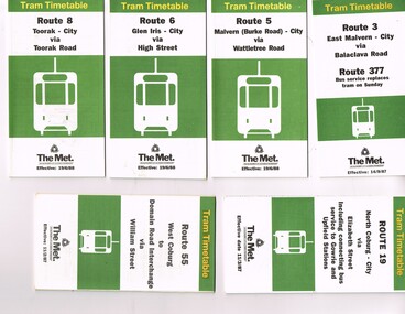
Ephemera - Timetable, The Met, Set of 18 Tram Timetables, produced by The Met, 1986 - 1988
... , giving a route map, description, notes, time points, information... with two green, multi fold horizontal sheet, giving a route map ...Set of 18 Tram Timetables, produced by The Met for various routes, white cover with two green, multi fold horizontal sheet, giving a route map, description, notes, time points, information contact details and types of tickets (Neighbourhood and Travelcards) and where they could be purchased. .1 - Route 3 - East Malvern - City via Balaclava Road - replaced by bus 377 on Sundays - dated 14/9/1987 .2 - Route 5 - Malvern Burke Road - City via Wattletree Road - 19/6/1988 .3 - Route 6 - Glen Iris - City via High St - 19/6/1988 .4 - Route 8 - Toorak - City via Toorak Road - 19/6/1988 .5 - Route 19 - North Coburg - City via Elizabeth St including connecting bus service to Gowrie and Upfield stations - 11/3/1987 .6 - Route 55 - West Coburg - Domain Interchange via William St - 11/2/1987 .7 - Route 57 - West Maribyrnong - City via North Melbourne - Route 357 bus replaces tram on Sunday - 1/12/1986 .8 - Route 59 - Airport West - City via Essendon -1/12/1986 .9 - Route 64 - East Brighton - City via Hawthorn Road - 14/9/1987 .10 - Route 67 - Carnegie - City via Glenhuntly Road - 14/9/1987 .11 - Route 69 - Kew (Cotham Road) - St Kilda Beach via Glenferrie Road - 19/6/1988 .12- Route 72 - Camberwell - City via Malvern Road - 19/6/1988 .13 - Route 75 - East Burwood - City via Flinders St - 15/2/1988 .14 - Route 78, Route 79, North Richmond - Prahran via Chapel St and North Richmond - St Kilda Beach via Chapel St - 13/7/1987 .15 - Route 82 - Footscray Moonee Ponds via Highpoint City and Route 223 bus replacement for Saturday afternoon and all day Sunday. 3/8/1987 .16 - Route 88 - Bundoora - City via Preston .17 - Route 96 - East Brunswick - St Kilda Beach via Bourke St City - 22/11/1987 .18 - Route 111 - Royal Exhibition Buildings - Port Melbourne via Bourke St City - 20/12/1987. (2nd copy added 1/4/20201( .19 - Route 600 - St Kilda - Middle Brighton via Elwood - 1/12/1986 Full Image of .5 added 9/4/17 following a query about route 19 timetables - see image i6.trams, tramways, timetables, tickets, tram services, route 3, route 5, route 6, route 19, route 55, route 57, route 59, route 64, route 8, route 67, route 69, route 72, route 75, route 78, route 78, route 79, route 82, route 88, route 86, route 111, route 600 -
 Melbourne Tram Museum
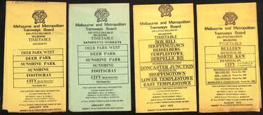
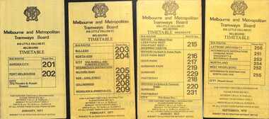
Ephemera - Timetables - MMTB Buses, Melbourne & Metropolitan Tramways Board (MMTB)
... , timing points, with a description of the route and a map..., with a description of the route and a map. Not all services had been ...Timetables - provide information on ticketing, fares, timing points, with a description of the route and a map. Not all services had been allocated a route number at the time. 1 - Deer Park West - Sunshine - Footscray - City - Jan 1975, including a separate weekend timetable' 2 - Box Hill - Shoppingtown - Templestowe - May 1975 3 - Bulleen - North Kew City - Routes 203, 204, 205, 206, 208 and 209 - August 1972 4 - North Altona - City - route 232 - June 1979 5 - Clifton Hill - Elsternwick route - route 246, Point Ormond - route 247 and 248 - June 1974 6 - La Trobe University - Northland - West Heidelberg - City - routes 256, 251, 253, 254, 252, 255 - August 1974 7 - Warrandyte - Park Orchards - Ringwood - routes 273, 274, 275 - Feb. 1974 8 - Warrandyte - Donvale - Templestowe - Shoppingtown - City - routes 276, 277, 278, 294, 278, 280, 299, 268 - April 1975 9 - East Kew, Box Hill Doncaster, Shoppingtown - routes 284, 285, 270 - May 1974 10 - Box Hill - Mitcham, East Doncaster, Ringwood - routes 287, 286, 288, 282, 283, 272 - March 1974' 11 - Box Hill - North Blackburn - route 290 - March 1974 12 - Fishermans Bend - City - routes 233, 235, 237 - Feb 1979.Yields information about MMTB Bus services during the 1970s.Set of twelve MMTB Bus timetables - multifolded printed on yellow paper, except for Deer Park timetables for Saturdays and Sundays printed on green paper.timetable, the met, buses, box hill, doncaster, templestowe, warrandyte, elsternwick, fishermans bend, deer park, altona, sunshine, footscray, shoppingtown -
 Melbourne Tram Museum
Ephemera - Timetables - MMTB Buses - set of 9, Melbourne & Metropolitan Tramways Board (MMTB), 1976 to 1978
... , timing points, with a description of the route and a map. Not all..., with a description of the route and a map. Not all services had been ...Timetables - provide information on ticketing, fares, timing points, with a description of the route and a map. Not all services had been allocated a route number at the time. 1 - Garden City - Port Melbourne - City - routes 201 and 202 - Jan. 1977 2 - Bulleen - North Kew City - Routes 203, 204, 205, 206, 208 and 209 - Feb. 1977 3 - Deer Park West - Sunshine - Footscray - City - routes 215, 216, 217, 219. 218, 220, 231 with a Saturdays and Sundays timetable sheet printed on green paper - Aug. 1977 4 - La Trobe University - Northland - West Heidelberg - City - routes 256, 251, 253, 254, 252, 255 - Sept. 1978 5- Warrandyte - Park Orchards - Ringwood - routes 273, 274, 275 - June 1976 6 - Warrandyte - Donvale - Templestowe - Shoppingtown - City - routes 276, 277, 278, 294, 278, 280, 299, 268 - July 1976 7 - Box Hill - Mitcham, East Doncaster, Ringwood - routes 287, 286, 288, 282, 283, 272 - June 1976 8 - Box Hill - North Blackburn - route 290 - June 1976 9 - Box Hill - Heidelberg, East Doncaster, Shopping town - routes 291, 297, 296, 293, 271 and 269 - Sept. 1976Yields information about MMTB Bus services during the mid 1970s. Set of nine MMTB Bus timetables - multifolded printed on yellow paper, unless noted otherwise. timetable, mmtb, buses, port melbourne, garden city, deer park, fisherman's bend, west heidelberg, box hill, doncaster, shoppingtown, mitcham, ringwood, blackburn, templestowe, lower templestowe -
 Ballarat Tramway Museum
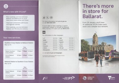
Pamphlet, Public Transport Corporation (PTC), "There's more in store for Ballarat", Jan. 2017
... of the introduction of revised routing of Ballarat bus services... of the introduction of revised routing of Ballarat bus services ...Set of two pamphlets distributed at the time of the introduction of revised routing of Ballarat bus services and the introduction of further trains on the Ballarat line - and the opening of Caroline Springs Station on 29.1.2017. .1 - 6 fold to DL size from an A3 sheets - titled "There's more in store for Ballarat", colour on white paper showing the new Ballarat bus network map, discontinued routes, additional train services and a summary of changes. .2 - a grab rail pamphlet listing the new bus routes for use on the buses - piece of heavy card with a round top and a slit to enable it to be placed on a grab rail within the bus itself. Two copies of each held.trams, tramways, ballarat public transport, buses, ptv, public transport victoria, timetables -
 Melbourne Tram Museum
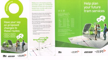
Pamphlet, Public Transport Victoria (PTV), "Help plan your future tram services", Jun. 2015
... . Shows the possible route changes on a map and basis.... Shows the possible route changes on a map and basis ...Set of two documents - pamphlets to ask passengers about the changes to routes 1, 6, 8 and 55 - 2015. .1 - 3 fold pamphlet, DL size colour on off white paper titled .1 - "Help plan your future tram services" asking feedback via an on-line survey. Shows the possible route changes on a map and basis of the changes. Has contact details on the rear. Two copies held. .2 -DL sheet cut for hanging within a tram, titled "Have your say on proposed changes to these routes - 1, 6, 8, 55, noting that a brochure could be picked up on the tram. Have PTV, Yarra Trams and Vic. Govt. logos.trams, tramways, route 1, route 6, route 8, route 55, route 58, tram routes -
 Melbourne Tram Museum
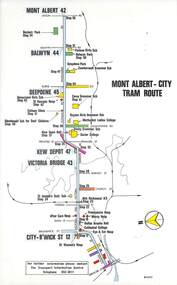
Map, Melbourne & Metropolitan Tramways Board (MMTB), Set of 15 tram route maps, 1977 to 1979
... Series of 15 colour route maps for various tram lines... Trams tramways Maps Route Guide Route Numbers Routes Mont Albert ...Series of 15 colour route maps for various tram lines or groups of tram lines for the MMTB. Some have the Transport Information Centre telephone printed on them, others have a label stuck on. Some are finished with a plastic laminate finish on either one or both sides. Show the major cross streets, parks, schools, other tram routes, major stop numbers and railway lines. Two copies of each held unless noted otherwise. .1 - Mont - Albert City - R11/77, shows routes 43. 47. 45. 44 .2 - Malvern, East Malvern, Carnegie and East Brighton Tram Routes (from St Kilda Junction) - R1/79 - shows routes 5, 3, 67, 66, 61, 62 and 64. .3 - Swanston St tram guide - R1/79 - lists all routes and route numbers that branch or cross Swanston St between Grattan St and St Kilda Junction. .4 - St Kilda Rd Tram Routes R12/77 - details South Melbourne Beach, route 1 and route 2 and St Kilda Beach routes 15, 16 and 55 otherwise shows were the various routes branch off St Kilda Road. Copy 1 has "P14909" in pencil in the bottom right hand corner. .5 - Kew - St Kilda Beach - R1/79 - Route 69. .6 - Footscray - Moonee Ponds - R3/81 - Route 82 .7 - Flinders St tram routes - R5/78 - North Balwyn, East Burwood, routes 48, 40, 41, Hartwell, 28, 74 and 75 .8 - William St tram routes - Route 55, 56 and 63 - South Melbourne Depot and Domain. copy 2 has "P14913" in bottom right hand corner. .9 - Toorak Camberwell and Glen Iris tram routes with Camberwell Junction and Malvern Town Hall, R1/79, routes 8, 7, 6, 72 and 73 shown. .10 - Swanston St tram routes - R12/77 - shows all the Swanston St routes, including East Coburg and Moreland. .11 - Bourke St tram routes - R4/77 - East Brunswick Blyth St and East Preston Tyler St and intermediate routes, routes 95, 96, 97, 90, 89 and 88. .12 - as for .11, dated 1/85, showing extension to La Trobe University - has Metropolitan Transit logo. Only 1 copy held. Also shows route 92 and 87. .13 - Batman Ave tram routes - R9/77 - Wattle Park, North Richmond and Prahran - routes 70, 71, 78 and 79. .14 - City route guide - R9/77 - showing all route numbers and destinations that passed through the CBD. .15 - Elizabeth St tram routes - R12/77 - Essendon Airport, West Maribyrnong, North Coburg lines, routes 50, 58, 60, 54, 57, 52. 49, 59, 18, 20 and 19. Copy 1 has "P14905" in pencil in bottom left hand corner.trams, tramways, maps, route guide, route numbers, routes, mont albert, route 43, route 47, route 45, route 44, route 42, malvern burke rd, east preston, carnegie, east brighton, south caulfield, route 5, route 3, route 67, route 62, route 64, route 66, glenhuntly tram depot, swanston st, st kilda rd, south melbourne beach, st kilda beach, route 1, route 2, route 15, route 16, route 55, kew- cotham road, route 69, route 79, route 82, footscray, moonee ponds, flinders st, north balwyn, kew, east burwood, burwood, hartwell, richmond, route 48, route 40, route 41, route 28, route 74, route 75, route 56, route 63, william st, west coburg, toorak, camberwell, glen iris, malvern town hall, route 72, route 73, route 7, route 8, bourke st, route 6, route 95, route 96, route 97, route 90, route 89, route 89, east preston, east brunswick, la trobe university, clifton hill, route 92, route 87, route 70, route 71, route 78, route 79, north richmond, prahran, wattle park, essendon airport, west maribyrnong, north coburg, route 50, route 58, route 60, route 54, route 57, route 52, route 49, route 59, route 18, route 20, route 19, batman ave -
 Bendigo Historical Society Inc.
Document - J W SWATTON COLLECTION: MAP OF NEW SOUTH WALES
... District, Motor tours Around Sydney, Routes to Brisbane, Road Map..., Motor tours Around Sydney, Routes to Brisbane, Road Map of New ...Two Road maps of New South Wales. C M Jones, Caltex Dealer, Golden Square, Bendigo stamped on the front. Map shows Sydney Outlet Roads, City of Sydney, City of canberra, Newcastle District, Motor tours Around Sydney, Routes to Brisbane, Road Map of New South Wales. It also lists the Principal Towns with Distances from Sydney and Interstate Road Mileages including Sydney to Melbourne via Hume Highway, Prince's Highway, via Canberra & Bombala. Also Sydney to Adelaide via Hume & Sturt Highways, Sydney to Brisbane via New England Highway, Pacific Highway via Toowoomba and Sydney to Adelaide via Western, Mid-Western and Sturt Highways.person, receipts, j w swatton, j w swatton collection, road map of new south wales, caltex, c m jones, e s sculley, clive barrass -
 Melbourne Tram Museum
Ephemera - Timetables - MMTB Buses - set of 13, Melbourne & Metropolitan Tramways Board (MMTB), 1971 to 1973
... , timing points, with a description of the route and a map. Not all..., with a description of the route and a map. Not all services had been ...Timetables - provide information on ticketing, fares, timing points, with a description of the route and a map. Not all services had been allocated a route number at the time. 1 - Garden City - Port Melbourne - City - routes 201, 202 - August 1972 2 - Williamstown Road - Footscray - Ballarat Rd - Route 223, Feb. 1972 3 - Deer Park, Sunshine Park, Sunshine, Footscray - City - routes 217, 219, 220, 229, 231 and 218 - Feb. 1972 4 - Deer Park West, Sunshine Park, Sunshine, Footscray - City - July 1973 5 - Fishermen's Bend - City - routes 233, 235 and 237 - March 1972 6 - Clifton Hill - Esternwick - Point Ormond - routes 246, 247 and 248 - August 1972 7 - Latrobe Uni - Northland - West Heidelberg - City - routes 256, 251, 253, 254, 252 and 255 August 1972 8 - East Kew, Box Hill, Doncaster, Shoppingtown - routes 284, 285 and 270 - July 1972 9 - Box Hill, Mitcham, East Doncaster, Ringwood - routes 287, 286, 288, 282, 283, and 272 - July 1972 10 - Box Hill - North Blackburn, route 290, printed on white paper - Sep. 1971 11 - Box Hill - Doncaster, Shoppingtown, Heidelberg, Templestowe, Serpells Rd and Lower Templestowe - routes 293, 296, 297, 271 - July 1972 12 Deer Park, Sunshine Park, Sunshine, Footscray - City - routes 217, 219, 220, 229, 231 and 218 - Saturdays and Sundays, printed on green paper - Feb. 1972 13 - Fishermans Bend - City - routes 233, 235 and 237 - June 1973 Yields information about MMTB Bus services during the 1970s. Set of twelve MMTB Bus timetables - multifolded printed on yellow paper, unless noted otherwise. timetable, mmtb, buses, port melbourne, garden city, williamstown rd, footscray, ballarat rd, sunshine, deer park, fisherman's bend, clifton hill, esternwick, point ormond, la trobe university, northland, west heidelberg, east kew, box hill, doncaster, shoppingtown, mitcham, ringwood, blackburn, templestowe, lower templestowe, fishermans bend -
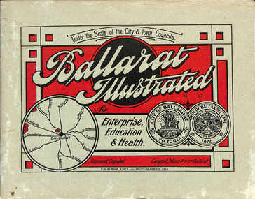 Ballarat Tramway Museum
Book, "Ballarat Illustrated", 1972
... with the places of interest and tram route map, marked in red. Pages... is a map with the places of interest and tram route map, marked ...Original c 1914 (see below), facsimile copy - re-published 1972. Original features photos of Ballarat City and Town, its buildings, parks and the various industries and organisations that were in Ballarat at the time of publication, including ESCo. Many photos features ESCo trams. Photos sepia toned. Has some red colour block printing on the front cover and rear, for Star Oil Engines. On inside back cover is a map with the places of interest and tram route map, marked in red. Pages are un-numbered. Original published by Ballarat East Town Council and Ballaarat City Council. On cover has number stamped in black in, "No. 87" (assume facsimile copy No.). Photos with publication show tram No. 21, built 1913 and ESCo photo page shows Mr. Pringle as Manager. Mr Pringle became manager in January 1911, As there is no photos of the "Avenue of Honour", or other mention of the first world war, assume original published about 1913 or 1914. Original shows Engravings and printing by "Campbell Wilson Prop Ltd, Ballarat". See Other Information as well for more listing details. High Resolution image added 31/8/2012 of i2 of ESCo page and i3 for Ballarat identies and sheet i4 extracted for Mr Pringle. PDF scan of full document added 21/5/2019 - see images btm633-1i.pdf and btm633-2i.pdf Notes on "Ballarat Illustrated" Reg. Item No. 733 From notes made by Neville Gower 12/1/1997 Cover: Inside front cover: Last paragraph, "Facilities for Travelling" - Electric trams serve all parts of Ballarat. Page 3: Street Scene, Municipal Town Hall, showing tram wiring Page 7: Street Scene, Lydiard St. North, intersection and tramway centre, with ESCo tram No. 21 in the bottom photo. Other photos features trams as well in Sturt St and Lydiard St. North. Page 9: Street Scene, Top photo of Sturt St. from Lydiard St. looking east, shows piles on right-hand side of road. Car parked by Post Office has a car registration number "9007". Bottom photo, an tram climbing hill, shows double trolley in the street, with early English type of pull offs. Page 13: Street Scenes and Historic Buildings: One of five photos, shows Victoria St. looking East, with tram track prominent in photo and how stone work was set up about the rails and overhead poles. Page 23: Street scene, Gardens North Entrance gates, shows details of gates near St. Aidans Drive. Note double trolley wire on poles, and style of insulators. No trams in photo, three ladies walking down the track. Page 37: Street Scene; Lydiard St views, top left hand photo, shows Railway station and railway gates with signal gantry and horse drawn vehicles. Tram tracks apparent. Bottom left hand photo shows Lydiard St. North, near Post Office, double track with centre poles - Single wire per track. Top right hand photo, showing Cemetery gates in background. Bottom right hand photo - from north end of Lydiard St. South, looking north, with an ESCo tram in background. Also has a parked car on left hand side. Page 45: Street Scenes - Bridge St; top photo at west end of Bridge St. with ESCo No. 11 with possibly double trolley wire in photo. Bottom photo at east end of Bridge St. with tram in background, shows junction. Double trolley heading out to Mt. Pleasant, single trolley for Victoria St. Page 45: Street Scenes - Bridge St; top photo at west end of Bridge St. with ESCo No. 11 with possibly double trolley wire in photo. Bottom photo at east end of Bridge St. with tram in background, shows junction. Double trolley heading out to Mt. Pleasant, single trolley for Victoria St. Page 61: Street Scenes and Historic Buildings - Public Institutions Ballarat - top left hand photo of the Hospital shows some tram track in foreground, with double trolley wire. Top right photo is of the Orphanage, the name of the tram terminus for many years. Page 68: Electric Supply Co. of Victoria's pages - top photo showing powerhouse in background, across the lake, can hardly see anything for the trees, except for the chimney. Bottom photos of the steam Turbo Generators and the switchboard. Gives Mr. P.J. Pringle as Chief Engineer and General Manager. He took over in Jan. 1911. Page 69: Ballarat East Views - features photo of Black Hill open cut, Ballarat East Railway Station, Ballarat Fire Station and "Victoria St. looking East", repeat of photo printed on page 12, but slightly darker. Image on system includes fire station and railway station, - Ballarat East. Page 78: Series of photos of various Ballarat VIP's of the era, fourth one in on top line features "P.J.Pringle, Electric Supply Co." Inside Back cover - map of Ballarat including tram lines and places of interest marked in red. Gives a detailed photographic presentation of Ballarat in 1914.80 page book with, in addition, light green card covers, titled "Ballarat Illustrated". Loose copy of page 9 and 10 held.trams, tramways, ballarat, local history, heritage buildings, esco -
 Melbourne Tram Museum
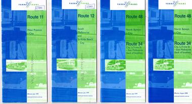
Ephemera - Timetable, Yarra Trams, Set of 15 Yarra Trams timetables, 7/1999 to 9/2001
... , frequency, Some include maps. .1 - Route 11 - West Preston - City... details, tram hire, frequency, Some include maps. .1 - Route 11 ...Set of 15 Yarra Trams timetables, blue green cover with route number on cover, giving details of popular destination, check points, use of Metcards and contact details, tram hire, frequency, Some include maps. .1 - Route 11 - West Preston - City - July 1999 - 24 Pages .2 - Route 12 - South Melbourne and St Kilda Beach - City - July 1999 - 24 pages .3 - Route 48 and Route 34 - North Balwyn - City or via Latrobe St - East Melbourne, includes references to Routes 23, 24, 27 and 30 - July 1999 - 28 pages, includes a small map. .4 - ditto - August 2000 .5 - ditto - September 2001 .6 - Route 70 - Wattle Park - City - October 1999 - 24 pages .7 - Route 70 - Wattle Park - City via MCG - December 2000 - 24 pages - includes a map .8 - Route 75 - East Burwood - City - July 1999 - - 24 pages .9 - ditto - August 2000 .10 - Route 86 - Bundoora RMIT - Colonial Stadium via Bourke St - March 2000 - 28 page. .11 - Route 96 - St Kilda Beach - East Brunswick -March 2000 - 24 pages .12 - Route 109 - Mont Albert - Port Melbourne - July 1999 - includes references to route 23, 24, 27. 30 and 34 - 36 pages .13 - Route 109 - ditto includes La Trobe St services - September 2001 - 36 pages .14 - Route 112 - South Melbourne - St Kilda Beach to West Preston via City, including temporary combination of routes 11 and 12, route 11 and Route 12 - August 2000 - 48 pages. .15 - Route 112 - notes that it the combination of Routes 11 and 12 - September 2001 - 48 pages. .16 - Route 11 - West Preston - City - Nov. 1998 - 24 pages .17 - Route 48 - North Balwyn - City - Dec. 1998 - 24 pages .18 - Route 34 and 48 - North Balwyn - City and City LaTrobe - East Melbourne - August 2000 - 32 pages .19 - Route 109 - Port Melbourne - Mont Albert - Nov. 1998 - 24 pages.Some have notes such as "OPR", and number notes and notes written inside about changes or errors in ink. See History.trams, tramways, yarra trams, tram services, timetables, route 11, route 48, route 34, route 23, route 24, route 27, route 30, route 70, route 75, route 86, route 96, route 109, route 112 -
 Melbourne Tram Museum
Pamphlet, Yarra Trams, "City Circle Tram Melbourne", 2003
... , c2003 - has route via Harbour Esplanade - map shows various... route via Harbour Esplanade - map shows various points ...Pamphlet - DL 6 fold from A3 sheet, full colour titled "City Circle Tram Melbourne", detailing the City Circle tram, c2003 - has route via Harbour Esplanade - map shows various points, the Golden Mile heritage walk. Notes that the route had recently been extended to run through Docklands. Has contact details but no web site. Has the Victoria government and Yarra Trams logos. Tram was extended early 2003. See Reg Item 866, 2703 and 2993 for other versions. Set of five additional pamphlets, all DL when folded about the Circle Tram - variants on a theme. All with a map. .1 - 6 fold - PTC - 1994 - could be the first pamphlet - has logos of State Govt, Agenda 21, Better Cities and PTC. .2 - 8 fold - Yarra Trams and Vic Govt - details the points of interest and general tram travel. .3 - 8 fold - 2009 - Yarra Trams, Vic tourism, city of Melbourne - as above. Running via Spencer St .4 - single DL sheet - 2009 update - extended service - to Docklands, with map .5 - single DL sheet - 2/2012 - simple details.trams, tramways, city circle, yarra trams, docklands, spencer st -
 Melbourne Tram Museum
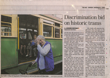
Newspaper, The Age, "Discrimination bid on historic trams", "Tram delays leave disable behind", 6/11/2006 12:00:00 AM
... returned. Has a map of route 96. Also quotes Daniel Bowen... returned. Has a map of route 96. Also quotes Daniel Bowen ...Series of four newspaper cuttings about discrimination access to trams and wheel chair users. .1 - The Age 6/11/2006 - "Discrimination bid on historic trams" - about Hazel Smith taking Dept of Infrastructure to court about the use of W class trams on the route 78 line. Notes she had a fall on this tram and suffered injuries. Has comments from the Dept and Yarra Trams. .2 - The Age? undated c2012 - "Tram delays leave disable behind" about the lack of progress in making trams more accessible, Australian Human Rights Commission, Transport, Minister Lynne Kosky and quotes from a wheel chair user, John McKenna and Vic Council of Social Services Cath Smith. .3 - The Age? - undated c2013 - Next trams years away for disabled travellers - similar issues - has a photo of Wendy Brooks in her wheelchair near the Royal Melbourne Hospital. .4 - The Age 10/5/2018 - "Tram traps: wheels not welcome" - looking at disability access tram stops, routes access and the cast of James Carter missing a stop and not able to get off until the tram returned. Has a map of route 96. Also quotes Daniel Bowen of the PTUA and Human Rights Commission.trams, tramways, melbourne, tramways, disability services, doi, route 78, route 96, superstops -
 Melbourne Tram Museum
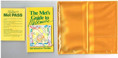
Book, The Met, "Met Pass", late 1980's
... November 1987. Rail Map - shows Route 96 north section as Light.... Rail Map - shows Route 96 north section as Light Rail, co ...Yellow plastic folder titled "Melbourne Met Pass", with The Met logo in green print on both sides of the outside of the folder. On the inside has two pockets for storing items formed with clear plastic. Map Folded Map of Melbourne Rail and Tram lines, titled "The Met PASS Map to Melbourne" Tram Map - probably soon after conversion of the St Kilda and Port Melbourne lines to Light Rail, though these are not shown. Opened November 1987. Rail Map - shows Route 96 north section as Light Rail, co-ordinated bus routes, and the Altona line as going to Werribee. This route was opened in 1985. Date of Map c1988/1990. Has details of Museums, Art Galleries, Shopping, Gardens and Sports Arenas in Japanese. Sheet of paper advising users on presentation of the Met Pass (not included in the folder) Book - titled "The Met's Guide to Melbourne", sub titled - Get around on The Met. Card covers, perfect bound, 100 pages in colour with maps, guides and information about various locations within Greater Melbourne including Werribee Zoo and Healesville. See also Reg Item 106 to 108 for a similar item and 983 for the document that was used to launch the Met Pass. Two copies held.trams, tramways, the met, melbourne, tickets, tourist tickets -
 Orbost & District Historical Society
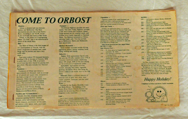
brochure, Come To Orbost, c 1980's
... . It contains the history, maps and touring routes of the Orbost..., maps and touring routes of the Orbost district. Come To Orbost ...This brochure was produced as a tourist guide to Orbost.This item is a useful research tool.A magazine/brochure for use as tourist information. It contains the history, maps and touring routes of the Orbost district.tourism-orbost