Showing 364 items matching "several copies"
-
 Greensborough Historical Society
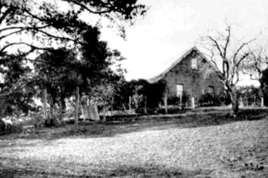
Photograph - Digital Image, Willis Vale, 1920c
Willis Vale: House built by Edward Maygar, Robert Whatmough lived there mid 19th century and later sold to Partington family. It was located on the Plenty River at Partington's Flat Greensborough. Land use included farming and orchards. The derelict Willis Vale house was destroyed in 1964 when a fire originating from North Plenty Gorge - Kurrak Road - was lit by two teenage boys and made its way several kilometres down to Partington's Flat Greensborough.Home of the Partington familyDigital copy of black and white photograph.willis vale, partington family, maygar, whatmough -
 Greensborough Historical Society
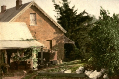
Photograph - Digital image, Willis Vale in Colour, 1940c
Willis Vale: House built by Edward Maygar, Robert Whatmough lived there mid 19th century and later sold to Partington family. It was located on the Plenty River at Partington's Flat Greensborough. Land use included farming and orchards. The derelict Willis Vale house was destroyed in 1964 when a fire originating from North Plenty Gorge - Kurrak Road - was lit by two teenage boys and made its way several kilometres down to Partington's Flat Greensborough.Home of the Partington familyDigital copy of colour photograph.willis vale, partington, whatmough, maygar -
![Photograph - Digital image, Willis Vale [front door], 1900c](/media/collectors/4f729f5697f83e03086015b8/items/55029fb42162f11024c2fdd5/item-media/55029fe62162f11024c300cd/item-fit-380x285.jpg) Greensborough Historical Society
Greensborough Historical SocietyPhotograph - Digital image, Willis Vale [front door], 1900c
Willis Vale: House built by Edward Maygar, Robert Whatmough lived there mid 19th century and later sold to Partington family. It was located on the Plenty River at Partington's Flat Greensborough. Land use included farming and orchards. The derelict Willis Vale house was destroyed in 1964 when a fire originating from North Plenty Gorge - Kurrak Road - was lit by two teenage boys and made its way several kilometres down to Partington's Flat Greensborough.Home of the Partington familyDigital copy of black and white photograph.willis vale, partington -
 Greensborough Historical Society
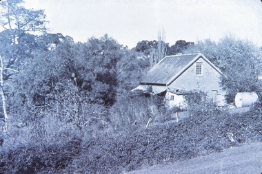
Photograph - Digital Image, Willis Vale, 1950c
Willis Vale: House built by Edward Maygar, Robert Whatmough lived there mid 19th century and later sold to Partington family. It was located on the Plenty River at Partington's Flat Greensborough. Land use included farming and orchards. The derelict Willis Vale house was vandalized in 1964 and destroyed when a fire originating from North Plenty Gorge - Kurrak Road - was lit by two teenage boys and made its way several kilometres down to Partington's Flat Greensborough. This photo was taken after the Partington's moved house in 1947; across the river where Alan built their new Alwyn house that had access to electricity.Home of the Partington familyDigital copy of black and white photograph.willis vale, partington, whatmough, maygar -
![Photograph - Digital image, Willis Vale [side view], 1950c](/media/collectors/4f729f5697f83e03086015b8/items/5502a2592162f11024c32328/item-media/5502a2852162f11024c3268d/item-fit-380x285.jpg) Greensborough Historical Society
Greensborough Historical SocietyPhotograph - Digital image, Willis Vale [side view], 1950c
Willis Vale: House built by Edward Maygar, Robert Whatmough lived there mid 19th century and later sold to Partington family. It was located on the Plenty River at Partington's Flat Greensborough. Land use included farming and orchards. The derelict Willis Vale house was vandalized in 1964 and destroyed when a fire originating from North Plenty Gorge - Kurrak Road - was lit by two teenage boys and made its way several kilometres down to Partington's Flat Greensborough. This photo was taken after the Partington's moved house in 1947. across the river where Alan built their new Alwyn house that had access to electricity. Home of the Partington family Home of the Partington familyDigital copy of black and white photograph.willis vale, partington, whatmough, maygar -
 Greensborough Historical Society
Article, Gillian M. Hibbins, Cordner, George Denis Pruen (1924-1990), by Gillian M. Hibbins, 1924-1990
Denis Cordner was born at Diamond Creek in 1924. He described himself as 'an industrial chemist and spare-time footballer'. The Cordner family were Greensborough locals, several being local doctors.Copy of article made 04/04/2017, 1 page.Originally published in Australian Dictionary of Biography, vol. 17, Melbourne University Press, 2007denis cordner -
 Greensborough Historical Society
Photograph - Digital Image, Willis Vale site, 2014_
Photograph of the site of the 'Willis Vale' homestead, home of the Partington family. The derelict Willis Vale house was destroyed in 1964 when a fire originating from North Plenty Gorge - Kurrak Road - was lit by two teenage boys and made its way several kilometres down to Partington's Flat Greensborough.Digital copy of colour photograph."This house is where Willis Vale homestead was on Partingtons Flat"partington family, willis vale -
![Photograph - Digital image, Charles Marshall et al, Marshall family [female relatives], 1930s](/media/collectors/4f729f5697f83e03086015b8/items/59b8998521ea6d02003aa0e6/item-media/59b899bb21ea6d02003acc4c/item-fit-380x285.jpg) Greensborough Historical Society
Greensborough Historical SocietyPhotograph - Digital image, Charles Marshall et al, Marshall family [female relatives], 1930s
This photograph shows several of the Marshall relatives, unidentified females, early 1930s Digital copy of black and white photograph. No caption on this photo.charles marshall, world war 1, marshall family -
 Greensborough Historical Society
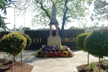
Photograph - Digital image, Marilyn Smith, Fallen Soldiers' Memorial, Greensborough, 22/08/2015
This photograph shows the World War I "Fallen Soldiers" Memorial at it's present site in War Memorial Park Greensborough.The Memorial was moved several times from its original site in Main Street to Greensborough Lower Park then to Memorial Park.Digital copy of colour photograph.greensborough war memorial park, fallen soldiers memorial greensborough -
 Greensborough Historical Society
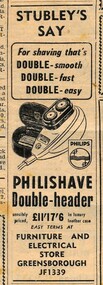
Advertisement - Digital image, Diamond Valley Local, Stubley's Stores, 15/12/1954
These advertisements were collected from the Diamond Valley Local newspaper. The Stubley group of companies operated several businesses in Greensborough.This advertisement is for a Greensborough based shop which no longer operates.Digital copy of newspaper advertisement.stubleys hardware, stubley -
 Glenelg Shire Council Cultural Collection
Photograph - Copy of Photograph - Mount Clay Aboriginal Tribe, 1859
Vern Mc Callum CollectionDigital copy of monochrome photo taken in Portland in 1859. Group of 14 men of a large tree trunk. They are dressed predominantky in European clothes. Several men have boomerangs and spears. -
Glenelg Shire Council Cultural Collection
Photograph - Copy of Photograph - Percy Street, Portland, Victoria, 1859
Vern Mc Callum CollectionDigital copy of monochrome photo taken in Portland in 1859. View of west side of Percy Street between Tyers and Henty Street. Several men standing on footpath. Man in horse and buggy. Another horse and buggy staning empty in street. -
Glenelg Shire Council Cultural Collection
Photograph - Copy of Photograph - Store of James Robertson, 1859
Vern Mc Callum CollectionDigital copy of monochrome photo taken in Portland in 1859. Store of James Robertson west side of Percy street. Between Henty and Tyers streets. Double storey tin building, with curved roof. Horse and cart standing in front. Two single storey bluestone buildings on left store, several people and large dog standing on the foot path. -
Glenelg Shire Council Cultural Collection
Photograph - Copy of Photograph - 'Prospect'- Thomas Must, 1859
Vern Mc Callum CollectionDigital copy of monochrome photo taken in Portland in 1859. Front and side view of 'prospect'. Several ladies and children centre front. On left a man holding a horse with a small child on its back, and a young girl standing with her hand on the horses rear. -
Glenelg Shire Council Cultural Collection
Photograph - Copy Of Photograph - Henty Wool Store, 1859
Vern Mc Callum CollectionDigital copy of a monochrome photo. Taken in Portland in 1859. Road in foreground, footpath with several men standing around. 3 two-storey blue stone buildings, with diffrent roof levels. Between building on left and middle buiding, is a horse and cart. -
 Yendon History Group
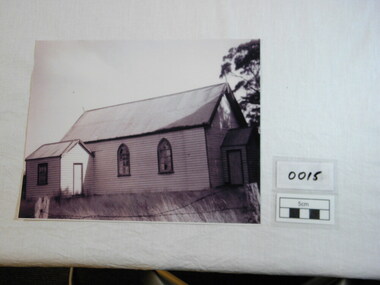
Photograph, Untitled, Yendon Catholic Church, Early 20th century
Importance of religion in the Yendon community is evidenced by the two churches. This is the weatherboard building of the catholic church and there was also a brick Anglican Church. Both these buildings were eventually removed when congregations declined as the community declined in the twentieth century.The catholic church was looking a bit delapidated in this photo taken just before it was demolished. Locals recall how the priest had to contend with all the birds nesting in the roof as the church slowly deteriorated.This is the only known photo ( as of 2010) of the Catholic Church in Yendon before it was removed.Enlarged printed copy of scanned Sepia photo of the Catholic Church, a wooden structure with a pitched tin roof, at Yendon just before it was removed.The grass is high and the barbed wire is not strained. The arched church windows have several broken panes of glass.It is a rectangular building with two additional spaces - an entry and a vestry. religion, tin roof, church, yendon, catholic, arched windows, vestry, broken panes of glass, weatherboard churches, pitched roofs, barbed wire -
 Eltham District Historical Society Inc
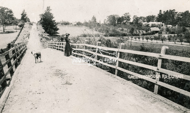
Photograph, Bridge over the Diamond Creek, Greensborough Road, Eltham, c.1885
Original (1874) bridge in Bridge Street, Eltham looking east over the Diamond Creek towards Maria Street (Main Road) at Little Eltham. In the distance to the right on Maria Street is the Methodist Church (1881), now Uniting Church, and the adjacent Commercial Bank of Australia branch building (1878). Part of a slide show presentation "Bridges & Waterways of the Shire" by Russell Yeoman to the 13 September 1989 Society meeting. The presentation included slides of historic photos from the Shire of Eltham Pioneers collections as well as several recent views.Photo of original 1875 timber and gravel surface bridge over the Diamon Creek in Bridge Street with views of orchards representative of the farming lands as well as the development along the northern end of Maria Street.Black and white photograph copybridge street, bridge street bridge, cba bank, diamond creek (creek), eltham, little eltham, main road, maria street, methodist church, uniting church -
 Warrnambool and District Historical Society Inc.
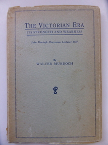
Book, The Victorian Era It's strengths & weaknesses, 1938
This book has been written by Walter Murdoch and it is the publication of two lectures given by Murdoch in 1937 (the John Murtagh Macrossan Memorial Lectures). John Murtagh Macrossan (1833-1891) was a Queensland politician who for some time held the seat of Townsville in the Queensland Parliament. He was born in Ireland and came to Australia in 1853, spending some time in the mining regions of Queensland. With Samuel Griffith he attended the first National Convention on Federation in 1891. Walter Murdoch (1874-1970) had a distinguished academic career and became Australia’s best-known essayist. He was a household name to two generations of Australians through his radio broadcasts and syndicated literary columns in several Australian newspapers. In 1901 Walter Murdoch came to Warrnambool and went into partnership with James Scott as proprietors of a private school, Warrnambool College. They bought out Stanley’s Warrnambool Grammar School and when Scott retired Murdoch became the sole proprietor and Head Master of Warrnambool College. While in Warrnambool in 1903 Murdoch wrote a school history book called ‘The Struggle for Freedom’, a book which sold 10,000 copies in its first year. Murdoch later became an English lecturer at Melbourne University and then the foundation Professor of English at the University of Western Australia. Murdoch University in Western Australia is named after him. He published over 40 books and he was knighted in 1964. This book is of interest as it was written by Walter Murdoch. He not only has a national reputation as an academic and writer but also he spent some time in Warrnambool and played his part in our history. This is a soft cover book of 66 pages. The cover was originally blue but is much faded, especially on the spine. The print on the cover and spine is dark blue and there is an ornamental edging on the front cover. The back of the cover has an advertisement for other Walter Murdoch books. The pages of the book are stained and the binding on the spine has broken away. walter murdoch, john murtagh macrossan, history of warrnambool, warrnambool college (early 20th century) -
 Warrnambool and District Historical Society Inc.
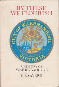
Book, C. E. Sayers, By These We Flourish A History of Warrnambool, 1969
... revision in 1987. However there are known now to be several ...History of Warrnambool to 1969This is a hard cover book with a sepia photograph on the cover and a cream-coloured dust cover with a colour image of the City of Warrnambool logo. Endpapers have a black and white 1840s sketch of a Plan of Township and Warrnambool Bay. There are 21 chapters and 16 pages of black and white photographs. There is a Foreword by Harold Stephenson, an introduction by the author, a Table of Contents, an Index, Appendices and lists of Warrnambool Councillors. non-fictionHistory of Warrnambool to 1969history of warrnambool book, ‘by these we flourish’, c e sayers, warrnambool -
Ringwood and District Historical Society
Newspaper - Newspaper Cuttings, Ringwood Memorial Clock Tower, 1928-1929
Several newspaper cuttings concerning the Ringwood Memorial Clock Tower: 3 pages of A4 with approx 8 cuttings copied. +Additional Keywords: Miles (Cr);McCaskill (Cr); MacKindlay (Cr) -
 Ringwood and District Historical Society
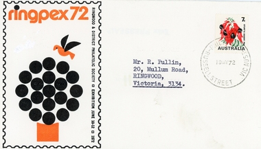
Memorabilia, Packet: Ringwood Philatelic Society founded 1952 - Rules, page of stamps, miscellaneous correspondence, Syllabus copies, 1952
PacketPacket includes: . Rules of the Ringwood and District Philatelic Society founded- 1952. . Page of stamps. Includes advice of meetings held first Thursday each month at Holeproof Canteen, Seymour Street, Ringwood, 8 PM. . Miscellaneous correspondence to Members. . Newspaper clippings back to 1940's. . Syllabus for several years. . Invitation for Mr R Pullin to Official Opening of "Ringpex 1972". -
Ringwood and District Historical Society
Document, Packet: Five Ringwood Movie Club booklets with several newspaper clippings re cinema 1990s
Packet includes: . 5 copies of Ringwood Movie Club newsletter titled "Take One" dated 1979 onwards. . Several newspaper cuttings from the 1990's re plans for a cinema complex in Eastland, and the dispute between the proposal by Ringwood Multiplex Cinemas' development at the Ringwood Market site in Bond Street. -
 Ringwood and District Historical Society
Photograph, 'The Dive' East Ringwood Knaith Rd. (undated). 2 views (undated)
View of lake with man shovelling rubbish into it from cart with horse. RE0028 shows close up view of same man. See also Item 2978 (Image RE0029) for full view of The Dive including Diving Tower.Typed below photograph, "'The Dive' East Ringwood Knaith Rd. where the aquatic sports were held. Being filled in after several drownings. Was clayhole from a brickworks. Now site of Ringwood East Community Centre". (3 copies) -
 Orbost & District Historical Society
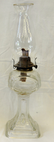
Lamp - kerosene, first half of 20th century
This lamp pattern was originally made in USA between 1880 and 1900. The pattern is called Feathered Cartouche and generally had a painted motif on each of the panels on the front. This lamp is probably a copy of the American lamp and made in Australia sometime in the first half of the 20th century. The lamp has an English style collar rather than an American one and the pattern is not as crisp as the American ones. There were several lamp patterns made here that were copies of American patterns and that style of collar was used on most of them. (ref Oil Lamp Antiques)This item is an important example of the early technology of artificial light. It has historical significance in demonstrating lighting devices used before the widespread use of electricity.Ornate clear glass kerosene lamp. Glass chimney is missing. Base is square and patterned with raised oval shapes, as is the stem. Both base and stem are hollow. At the top, the kerosene holder is squarish with round corners.. The wick holder is of brass and has a small wick adjustor.lamp, kerosene lamp, lighting - domestic -
 Orbost & District Historical Society
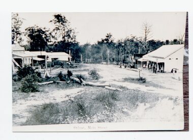
black and white photograph, 1889
This photograph has been taken looking down Nicholson Street, Orbost. Temple's Store is on the left and the Club Hotel on the right. The township began to take shape about 1885. (More information from Newsletter August, 2004 Pauline Wilkinson)This is a very early pictorial record of early Orbost township.Three copies of a black / white photograph of a main road, unsealed with wooden buildings on both sides.The building on the right side of the photograph has a verandah with several people standing under the awning, There seems to be two or three young children further down on the edge of the road.on front at bottom - Orbost Main Street -
 Orbost & District Historical Society
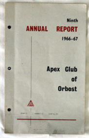
Booklet - ANNUAL REPORT, Ninth ANNUAL REPORT 1966-67 Apex Club of Orbost
This is a report of 1966-67 functioning of the Apex Club of Orbost. It has a membership list at the back of the booklet and also contains the names of office bearers etc. This Report was presented to the Handover Dinner 5 August 1967. President Don McKenzie; Vice Presidents Dennis Robinson, David Neal; Treasurer Graeme Duff; Secretary Keith MurrayEvidence of the functioning of the Apex Club of Orbost 1966-67 with names of members, activities, finances.A booklet of 13 pages with a grey coloured cover. On the cover are the words Ninth ANNUAL REPORT 1966-67 Apex Club of Orbost ZONE 12 DISTRICT 6 CLUB No. 251. Inside are copied pages of the Report including names of committee members, board members, and past presidents, also several b/w photos of activities, financial report, awards, and the President's Report 5 August 1967. as aboveapex club, orbost -
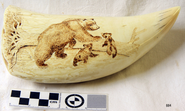 Flagstaff Hill Maritime Museum and Village
Craft - Scrimshaw
When scrimshaw is mentioned, most people think of carving on sperm whale teeth only. But scrimshaw also includes engravings on skeletal whale bone–such as the jaw bone, called panbone–and ivory from other marine mammals such as walrus. Although scrimshaw is widely associated with nautical themes and designs of the 19th century whaling industry, vintage scrimshaw was also produced as tribal art in many cultures. Today, scrimshaw is recognized as a unique medium in which present-day artists have developed their own modern themes. Scrimshaw reproductions may take several forms. There are - New carvings on genuine ivory or bone with the deliberate intent to create an "antique” - New carvings on genuine ivory or bone sold as signed and dated contemporary art - Clearly marked synthetic museum reproductions and mass marketed - Unmarked synthetic replicas Painstakingly carved deliberate replicas are directed towards the scrimshaw collector and seldom appear in the general market. Pieces of contemporary art and museum copies are usually clearly marked and openly sold for what they are. The biggest problems in the general antiques market are the mass produced synthetic reproduction pieces, such as this item, that can be mistaken for the genuine item. The scrimshaw is a modern reproduction of a typical scrimshaw scene and engraved onto a synthetic substance. It has been created as a decorative piece and is currently displayed as a representation of the craft of scrimshaw.Scrimshaw carved on a non-natural material in the shape of a whale tooth. Engraving depicts a grizzly bear with two cubs next to a fallen tree. Nonewarrnambool, flagstaff-hill, flagstaff-hill-maritime-museum, maritime-museum, shipwreck-coast, flagstaff-hill-maritime-village, craft work, carving on bones, whale bone carving, engraving, scrimshaw, carving, reproduction scrimshaw -
Glen Eira Historical Society
Book - CAULFIELD CENTENARY 1957
This file contains four items 1/Two copies of a twenty-four page booklet titled CITY OF CAULFIELD CENTENARY 1857-1957, created by the Caulfield City Council and printed by Peter Isaacson Pty Limited, Melbourne. The booklet details important aspects of Caulfield’s history including council procedures, the Caulfield Road District Proclamation, the first election and a summary of 100 years of local government with a description of the present Caulfield in 1957. The booklet also includes several pictures of various Caulfield landmarks and people including one of Caulfield City Councillors (11 men and 1 woman). Also one photocopied version of this booklet. 2/Eleven pages of typed notes for the City of Caulfield Centenary booklet. All notes are undated and incomplete. Two pages titled NOTES on THE HISTORY and PROGRESS OF THE CITY OF CAULFIELD, author unknown. Three and a half pages titled THE STRUCTURE OF LOCAL GOVERNMENT IN VICTORIA, author unknown. Five pages titled 100 YEARS OF LOCAL GOVERNMENT – EARLY CAULFIELD, by Mrs A. P. Bell. 3/A typed letter to Miss V. Webb-Langdon from the Town Clerk H.G. Nelson, acknowledging her contribution to historical details for the Caulfield Council’s Centenary booklet, dated 24/12/1957. 4/A handwritten letter and a handwritten note regarding the acquisition of notes for the Caulfield Centenary booklet. The letter is dated 03/08/2006 and the note is dated 09/02/2007.city of caulfield centenary, caulfield road district, sinclair a.j.g., city hall, war memorials, gamble h.a., machin l.r., bunny f.c.d., caulfield park, koornang reserve, parton e.m., sims h.e., thomson w.r., gunn e.e., yorston j.s., wallace g.e. mrs, green w.c., jenner e.r., ward boundaries, dandenong road, queens avenue, normanby road, station street, bond street, glen eira road, orrong road, poath road, north road, booran road, nepean highway, glen huntly road, glenhuntly road, inkerman road, hotham street, nelson h.g., fullard w.r., mackley g.j., ellis k.i, crosbie m.r., nutting b.i., body j.h., pritchard r.j., guildford l.t.g., lund l.m., street h.c., reynolds a.w., elections , political processes, local government, springthorpe reserve, greenmeadows gardens, business and finance, roads and streets, caulfield racecourse, east caulfield reserve, mackinnon reserve, hawthorn road, balaclava road, murrumbeena road, lempriere avenue, victoria street, koornang road, lord reserve, lyons street, murrumbeena reserve, kangaroo road, ormond park, beatty crescent, foch street, packer reserve, oakleigh road, leila road, prices park, bambra road, riley reserve, playgrounds, town hall, maternal and child health centres, truganini road, grange road, senior citizens centre, barkley sir henry, moore david, handasyde gilbert, caulfield school room, harris g.w., semple john, dempsey william, brooks w.a., wilson thomas, lyall william, murrum murrumbeen lifestyle, ‘greenmeadows’ house, lempriere family, aboriginal culture, ‘rippon lea’ house, caulfield john, ‘slaney’s’ home, alma road, paddy’s swamp, racecourse hotel, caulfield technical college, bevan mr., ‘grosmont’, hart john, railways, mansions, ‘rosecraddock’, langdon h. j., caulfield cup, ‘crotonhurst’, webb judge, ‘kilwinning’, service james, ricketson henry, ‘glen eira’, house names, garden vale, ross william murray, ‘ross’s folly’, outer circle railway, caulfield grammar school, davies j. henry, lagdon william, grimwade f.s., loyd charles du plan, hope george, ‘airdrie’, kooyong hill, market gardens, dairies, lady talbot milk supply, jenner family, o’niell college, presentation sisters, glenferrie road, grimwade frederick sheppard, grimwade alice, ‘harlston’, grimwade house, ‘saint aubin’s’, ‘st. aubin’s’, ‘caulfield hall’, caulfield john p.t., st georges road, caulfield military hospital, nursing homes, health establishments, dover street, sports and recreations, rosanna street, ‘cantala’, health services, parks and reserves, community services, town planning, local government finance, local officials and employees -
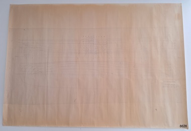 Flagstaff Hill Maritime Museum and Village
Plan - Lines Plan, S.S. Rowitta, ca 1909
The lines plan was drawn for the building of the steamship S.S. Rowitta, a passenger steam ferry built in Hobart for use in Tasmania's rivers, the Derwent and the Tamar. It is a copy of the original lines plan. The S.S. Rowitta was built by Purdon & Featherstone, at Battery Point, Hobart (Tasmania) in 1909 from Huon Pine and Kauri planking. Her final configuration included three masts and a ship rig. S.S. Rowitta took its first voyage from Hobart to Launceston in 1909 and operated for 30 years as a passenger ferry on the Tamar and Derwent Rivers. She also served as a freighter, an army supply ship, a luxury charter ferry and a floating restaurant as well as a prawn boat at Lakes Entrance. (She has also been named “Sorrento” and “Tarkarri”.). In the very early days of Flagstaff Hill ‘Rowitta’ was purchased from Lakes Entrance by Warrnambool City Council and the Victorian State Government for $20,000. The Rowitta had a hull configuration very similar to a local boat named the SPECULANT, which played a key role in the Port of Warrnambool in the early 1900s. The Speculant was the largest ship ever registered with Warrnambool as her home port. Local owner and trader P J McGennan & Co, (Peter McGennan) used her as a freight carrier to Melbourne and timber trader between New Zealand and Victoria. She sunk at Cape Otway in 1911 on a voyage to Melbourne. In 1974 Rowitta was delivered to Port Fairy and then later sailed to Warrnambool’s Breakwater where she was lifted out of Lady Bay and loaded onto the back of a long transport truck and slowly and carefully driven along Pertobe Road, through the Surfside Caravan Park and over the railway line, into Flagstaff Hill’s Maritime Village. Transfer arrangements were coordinated by Jack Morse, of Morse Engineering, a member of the Flagstaff Hill Planning Board, and Ken Goyen, a local crane operator. The ‘Rowitta’ was originally acquired to be rebuilt to match the original SPECULANT. When finances became tight in 1976 a review of all plans ended in the decision to restore the “Rowitta” to her original configuration. She was then restored, renamed the original name of “Rowitta” and installed in the Village’s Harbour Lake to become one of the popular vessels on display for visitors to enjoy. It was the decision of the Advisory Committee to Flagstaff Hill to have Rowitta demolished in April 2015 due to extensive deterioration. Items associated with the Rowitta continue to be held in Flagstaff Hill Maritime Village’s Collection.The lines plan of the passenger ferry S.S. Rowitta.is significant for its association with Tasmanian history from the early to mid-1900s. It is also connected to the history of the Rowitta, which was a large exhibit on display at Flagstaff Hill Maritime Village from the museum’s early beginnings until the vessel’s end of life 40 years later. The Rowitta represents the importance of coastal traders to transport, trade and communication along the coast of Victoria, between states, and in Australia before rail and motor vehicles. The vessel was an example of a ferry built in the early 20th century that served many different roles over its lifetime of over 100 years. Lines Plan, copy, of the steamship S.S. Rowitta. Rectangular drawing paper with copy of the hand drawn lines plan showing several profiles of the vessel. The vessel was built in 1909 by Purdon & Featherstone, Hobart. On the revers is handwritten inscription, and a white label with a handwritten number.Printed on the plan: "S.S. ROWITTA / LINES PLAN / SCALE 1/4" TO 12" " Blue ink writing on the back: "Rowitta" Blue ink on label: "56"flagstaff hill, warrnambool, shipwrecked-coast, flagstaff-hill, flagstaff-hill-maritime-museum, maritime-museum, shipwreck-coast, flagstaff-hill-maritime-village, photograph, s.s. rowitta, charles street wharf,, launceston., purdon & featherstone, rowitta, tarkarri, speculant, purdon & featherstone of hobart, passenger ferry 1909, sorrento, lines drawing, ship's plan, lines plan, line plan, shipbuilding, ferry -
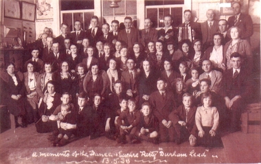 Federation University Historical Collection
Photograph, A memento of the dance and euchre party Durham Lead 13.5.38
Durham Lead (also known as Durham, 1870s) was a mining township 15 km south of Ballarat. It was one of several mining centres along the main mining lead running south of Ballarat, generally along the valley formed by the Yarowee or Leigh RiverCopy of a sepia tone black and white photograph of a large group of men, women and children taken at the dance and euchre party Durham Lead 13 April 1938. Front row sitting on the seat (not the floor):- 4th from left, Mrs. Minnie Scott (nee Kinsey); 5th from left, Miss Lucy Kinsey; 1st right, Mr Thomas Scott Jnr. (dark suit & tie) 2nd back row:- 7th lady from right, wearing glasses, slightly behind, Miss Catherine (Kit) Scott A memento of the dance and euchre party Durham Lead 13.5.38durham lead, leigh river, garibaldi, gold