Showing 9459 items
matching the road to lower plenty
-
 Eltham District Historical Society Inc
Film - Video (DVD), Nillumbik Shire Council, Edendale Farm Community Environment Centre: History, c.2009
EDENDALE FARM Edendale Farm is Nillumbik Shire Council's environment centre situated in Gastons Road, Eltham between the railway and the Diamond Creek. The homestead on the property was built in 1896 and is of historical significance, being the subject of a Heritage Overlay under the Nillumbik Planning Scheme. The Edendale property was originally part of an extensive land purchase in 1852 from the Crown by pioneer Eltham farmer Henry Stooke. He initially purchased 51 acres and later expanded his holdings by purchasing another three adjacent Crown allotments extending northerly from Josiah Holloway's Little Eltham subdivision. Despite clearing the land, Stooke did not build on this property, choosing to live on his property "Rosehill" at Lower Plenty. In 1896 Thomas Cool, Club Manager of the Victoria Coffee Palace in Melbourne purchased 7 acres of the original Stooke land and built the house now known as Edendale. Cool did not farm the land, instead using it as a gentleman’s residence, retiring to Eltham at weekends. In 1918 he purchased an additional 7 acres but in 1919 he sold the property. Later owners included J.W. Cox, the Gaston family and D. Mummery. In the 1980s the Eltham Shire Council purchased the site for use as a Council depot, but this use did not proceed. Subsequently, it was used as the Council pound. The Edendale Farm Pet Education and Retention Centre was established in the summer of 1988/1989 and was set up to replace the existing dog kennels with a high standard pet retention centre. The design style of the building was established to compliment the features of the existing house. It was equipped with 10 retention pens, a veterinary room and a pet education area where school children and other interested parties learnt about pet care procedures. It was later developed into a community farm and was run by an advisory committee and in 2000 it became an Environment Centre. In early 2006 an advisory committee was established for the development of a master plan for future development at Edendale Farm. The committee included Russell Yeoman, a former long-time shire planner and founding member of the Eltham District Historical Society. At the time of filming the Master Plan and future for Edendale was about continuing to develop Edendale as a centre of environment learning and looking at expanding displays and school program, running a lot more of life-long learning and workshops around sustainable living.edendale community farm, eltham, gastons homestead, gastons road, shire of nillumbik, video recording -
 Eltham District Historical Society Inc
Document - Folder, Mash, Amelia
Amelia Mash (nee Romerill), resident of Briar Hill and Eltham for more than 70 years, had died. Contents Newspaper article: "Loved for her kindness" Diamond Valley News, 1 November 1995, outlines the life of Amelia Mash (nee Romerill) who lived in Brian Hill and Eltham for more than 70 years.. Newspaper article: "Tourism needs public support" Diamond Valley News, 1 November 1995, Nillumbik Council has appointed La robe University to develop a tourism strategy for the shire. Megan Ritchie, LaTrobe University lecturer, will lead the team.Newspaper clippings, A4 photocopies, etcamelia mash, amelia romerill, annie roberill, bert romerill, williams road briar hill, john mash, dorothy mash, montmorencyfootball club, lower plenty football club, lower plenty cricket club, eltham cricket club, bundoora united cricket club, diamond valley basketball association -
 Eltham District Historical Society Inc
Map (item) - Sales Brochure, Plenty Township Estate and Bryn Teg Hill's Estate, Coghill & Haughton, Melbourne, c.1924
... lower plenty road... hotel houses lower plenty lower plenty bridge lower plenty road ...Plenty Township Estate "The rapid growth of Greensborough and the great traffic development on the main road between Heidelberg and Eltham augurs well for Plenty Township Estate. Already a Store, Post Office and State School have been started, and the activities of the Local Progress Association will help the district forward considerably. Within walking distance of the Montmorency and Greensborough stations." Bryn Teg Hill's Estate "Better known as "The Old Sand Hill, "within walking distance of the Montmorency and Greensborough railways stations." "Some few years back Mrs Thomas subdivided portion of the Sand Hill Paddocks, and the areas sold have been settled and many converted into charming outer suburban garden homes with cultivation and orchard plots. The south-eastern slope gives the land a grand outlook over the Yarra Valley on to the Dandenoings, and the are is very picturesque and homely." "A number of the blocks contain large deposits of valuable building sand, which should prove good speculation in view of the forecast for further rapid home development along the Eltham Suburban Electric Service." Sand Hills Road (Old Eltham Road) Date estimated as c.1924 - Electricification of railway line to Eltham referenced on map occured April 1923 and Mrs Mary Thomas died August 1925. Her home Bryn Teg became part of the Heidelberg Golf Club in 1927.The establishment of Lower Plenty as a suburban growth area supported by easy commuting facilitated by the elctrification of the Eltham railway linebonds road, bridge, bryn teg hill's estate, coghill & haughton, eltham road, heidelberg golf club hotel, houses, lower plenty, lower plenty bridge, lower plenty road, main road, plenty hotel, plenty river, plenty township estate, real estate agent, sales brochure, sand hills road, the old sand hill, sand hill paddocks, woodfull road, old eltham road, bryn teg, mrs m thomas -
 Eltham District Historical Society Inc
Photograph, Liz Pidgeon, Public Records Office Victoria (PROV) visit to Eltham Justice Precinct, 20 Apr 2018
The original Shire of Eltham was founded in 1871. Prior to its founding, the district was managed by the Eltham District Road Board, which was established in 1856. The initial rate assessment commenced in 1857 for the year ending October 14, 1858. The honour of being recorded with the first assessment went to a farm of 110 cultivated acres at Lower Plenty, owned by John Porter and occupied by Albert Baines. It was assessed at 6d/acre providing for a rate income of £2 15s. In July 2017, officers at Nillumbik Shire Council discovered some early Eltham Road District Assessment books and donated them to the Eltham District Historical Society. The seven volumes were the district’s first six years of rate assessments. This was a unique and significant record of early settlers in the pre-Shire of Eltham. They immediately became one of the oldest and most valuable items in our collection. An article on page 5 in the Eltham and Whittlesea Shires Advertiser, Friday, 21 November, 1941 titled: ‘District’s Early History‘ states: “The first rate book which is still in existence at the Shire Office is for the year ending October 14, 1858 and is probably the best record possible to indicate the development of the district. At the time properties were rated as follows: Cultivated land. 6d. per acre; pasture land, 1d. per acre: estimated annual value of buildings, etc., 6d in the (pound). The total amount of rate recorded for the year was £153/14/8. Properties were described as being situated at Lower Plenty, Yarra Yarra, Eltham, Lower Eltham, Kangaroo Ground, Yarra Flats, Diamond Creek and the Yarra.” Given the precious nature of this collection, priority was given to digitise the rate books and place them in suitable archival storage to minimise further handling. Subsequent discussion amongst our Collections team arrived at the conclusion that the most appropriate home for this valuable record was the Public Record Office Victoria (PROV), the archive of the State Government of Victoria and who are charged with archiving and caring for all Government related records. An approach was made to PROV who confirmed these records would complete their collection of rate assessment books for Eltham. At a small ceremony held Friday, April 20 at the Local History Centre, Eltham, members of the Society and our Collections team, along with Ms. Vicki Ward, MP for Eltham, presented the seven volumes for 1858-1863 along with the complete set of digital files to Mr. David Taylor, Community Archives Manager and Mr. Charlie Farrugia, Senior Collection Advisor, Public Record Office Victoria.Born Digitalassessment ledger, donation, eltham courthouse, eltham road district, local history centre, public records office victoria (prov), rate books, eltham district road board -
 Eltham District Historical Society Inc
Photograph - Digital Photograph, Jim Connor, Edendale Farm Homestead, 11 December 2014
Edendale Farm is Nillumbik Shire Council's environment centre situated in Gastons Road, Eltham between the railway and the Diamond Creek. The homestead on the property was built in 1896 and is of historical significance, being the subject of a Heritage Overlay under the Nillumbik Planning Scheme. The Edendale property was originally part of an extensive land purchase in 1852 from the Crown by pioneer Eltham farmer Henry Stooke. He initially purchased 51 acres and later expanded his holdings by purchasing another three adjacent Crown allotments extending northerly from Josiah Holloway's Little Eltham subdivision. Despite clearing the land, Stooke did not build on this property, choosing to live on his property "Rosehill" at Lower Plenty. In 1896 Thomas Cool, Club Manager of the Victoria Coffee Palace in Melbourne purchased 7 acres of the original Stooke land and built the house now known as Edendale. Cool did not farm the land, instead using it as a gentleman’s residence, retiring to Eltham at weekends. In 1918 he purchased an additional 7 acres but in 1919 he sold the property. Later owners included J.W. Cox, the Gaston family and D. Mummery. In the 1980s the Eltham Shire Council purchased the site for use as a Council depot, but this use did not proceed. Subsequently, it was used as the Council pound. The Edendale Farm Pet Education and Retention Centre was established in the summer of 1988/1989 and was set up to replace the existing dog kennels with a high standard pet retention centre. The design style of the building was established to compliment the features of the existing house. It was equipped with 10 retention pens, a veterinary room and a pet education area where school children and other interested parties learnt about pet care procedures. It was later developed into a community farm and was run by an advisory committee and in 2000 it became an Environment Centre. In early 2006 an advisory committee was established for the development of a master plan for future development at Edendale Farm. The committee included Russell Yeoman, a former long-time shire planner and founding member of the Eltham District Historical Society. At the time of filming the Master Plan and future for Edendale was about continuing to develop Edendale as a centre of environment learning and looking at expanding displays and school program, running a lot more of life-long learning and workshops around sustainable living.jim connor collection, edendale community farm, edendale farm, eltham, gastons road -
 Eltham District Historical Society Inc
Album - Photograph Album, J.A. McDonald, Bridge and Road Reconstruction Works, Shire of Eltham, 1952-1962
... Lower Plenty Road... Bridge Long Gully Creek Long Gully Road Long Gully Lower Plenty ...J.A. McDonald produced this record in the course of his responsibilities as Shire Engineer for Eltham Shire Council.Record of various Shire of Eltham infrastructure works undertaken during the period of 1952-1962 involving bridge and road reconstruction projects, sometimes with Eltham Shire Council Project Reference numbers quoted. It was during this period that a number of significant improvements were made to roads and new bridges constructed within the shire that remain in place as of present day (2022). In many situations, the photos provide a tangible visible record of infrastructure that existed throughout the early days of the Shire. The album was put together by or under the direction of the Shire Engineer, J.A. McDonald.a. gillies, alistair knox park, benchmark studies, bend of islands, blease road, box hill state school, box hill teachers college, box hill tip, bridge construction, bridge street bridge, bridge, brisbane street, brougham steet, bulldozer, cecil street, charis pelling, cherry tree road, city of preston, cr. a. brinkkotter, cr. charis pelling, cranes, cromwell street, diamond creek (creek), diamond street, dixons creek bridge, dixon's creek road, drott, eltham leisure centre, eltham north, eltham police station, eltham, eltham-yarra glen road, f. wood, fitzsimons lane bridge, flat rock road, flood damage, floods, floodwater, footpaths and gutters, ford service garage, g. blair, garden hill, glen park bridge, glenauburn road, grand hotel, haldane road, healesville, healesville-yarra glen road, heidelberg-kinglake road, henley road bridge, henley road, hill property, hurstbridge water scheme, hurstbridge, hurstbridge-arthurs creek road, infrastructure, j. jolly, kangaroo ground, kangaroo ground-queenstown road, kangaroo ground-st andrews road, lilydale shire office, long gully bridge, long gully creek, long gully road, long gully, lower plenty bridge, lower plenty footbridge, lower plenty oval, lower plenty road, lower plenty, main road, methodist church, montmorency, mount pleasant road, new holland, old healesville road, opening ceremony, oxley bridge, para road, paul creek bridge, paul creek road, paul krafeznk, pinnacle lane, plaques, plenty river trail, plenty river, presbyterian church, prof donald thomson, pryor street, railway crossing, railway parade, rattray road, reconstruction works, reichelt avenue, research (vic.), research oval, road construction, rymers corner, shire of eltham, shire of whittlesea, silvan road bridge, silver street bridge, silver street, sir dallas brooks, smedley property, st andrews, steels creek, susan street, tarrawarra, tony carberry, uniting church, upper yarra dam, upper yarra reservoir, w.e. wolf, waterfall property, watsons creek, wattletree road bridge, wattletree road, wattletree road bridge, worlingworth, yarra glen, york street, yow yow creek -
 Eltham District Historical Society Inc
Album - Photograph, J.A. McDonald, Eltham-Yarra Glen Road, 18 Oct. 1956
Eltham-Yarra Glen Road Proposed crossing of Plenty River at Lower Plenty. Floods 18th October 1956.Record of various Shire of Eltham infrastructure works undertaken during the period of 1952-1962 involving bridge and road reconstruction projects, sometimes with Eltham Shire Council Project Reference numbers quoted. It was during this period that a number of significant improvements were made to roads and new bridges constructed within the shire that remain in place as of present day (2022). In many situations, the photos provide a tangible visible record of infrastructure that existed throughout the early days of the Shire. The album was put together by or under the direction of the Shire Engineer, J.A. McDonald.infrastructure, road construction, shire of eltham, bridge construction, eltham-yarra glen road, 1956-10-18, floods, floodwater, lower plenty, plenty river -
 Eltham District Historical Society Inc
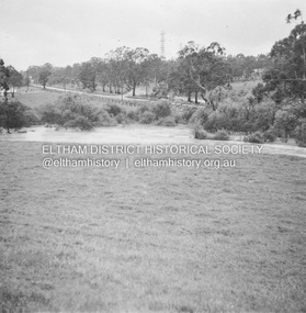
Document - Property Binder, Main Road
... melbourne Main Road Lower Plenty Eltham Research (Vic) Property ...main road, lower plenty, eltham, research (vic), property, houses, shops, businesses, montmorency -
 Eltham District Historical Society Inc
Document - Property Binder, Plenty River Bridge, Main Road, Lower Plenty
... Plenty River Bridge, Main Road, Lower Plenty..., Main Road, Lower Plenty Document Property Binder ...Extracts Heidelberg Council Minutes re Plenty Bridge, 3 September1862, 10 May 1865, 22 May 1865, 5 June 1865 , 10 October1866, 14 November1866, 13 February 1867.main road, property, houses, shops, businesses, plenty bridge -
 Eltham District Historical Society Inc
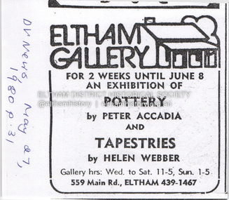
Document - Property Binder, 559 Main Road, Eltham
... 410 Main Road Lower Plenty... Montmorency 410 Main Road Lower Plenty Abbey of Diamond Creek Adams ...Newspaper advertisement: Diamond Valley News, 27 May 1980, Exhibition, Peter Accadia, pottery, and Helen Webber, tapestries. Newspaper article: Five for the price of one, Diamond Valley News, Tuesday, July 8, 1986, p27; exhibition of five artists at Eltham Gallery. On reverse, numerous advertisements for food and entertainment Newspaper advertisement: The Age ,17 June 1989, Exhibition, Donald Ramsay "Watching the river flow". Newspaper article: Landmark gallery says goodbye, Diamond Valley Leader, 24 November 2004, Gallery site sold to Sentinel Equities, present tenant Julie Skate, quotes from former part-owner Val Murray. Newspaper article: Rift over gallery plans, Diamond Valley Leader, 21 February 2007, purchasers Jethro Tull and Suzanne Still plan to build offices, gallery and cafe; Eltham Gateway Action Group objected while supporting need for a gallery elsewhere. Newspaper article: New try for gallery-cafe ready soon, Diamond Valley Leader, 18 April 2007, purchaser Jethro Tull to have a new plan ready in two weeks for gallery and cafe. Newspaper article: Gateway for artists, Diamond Valley Leader, 25 May 2007, Jenni Mitchell opened a new gallery pending decision by Nillumbik Council. Newspaper article: Art gallery proposal rejected, Diamond Valley Leader, 30 May 2007, Nillumbik Council against planned new building. Newspaper article: Artful win for gallery, Diamond Valley Leader, 30 January 2008, VCAT approved mudbrick art gallery. Newspaper article: Rocky road to create a landmark, Diamond Valley Leader, 13 February 2008, VCAT approved Robert Marshall's design, artists's impression, Eltham Gateway Action Group opposed.main road, property, businesses, eltham gallery, wiregrass gallery, eltham gateway action group, robert marshall, mud brick building, eltham (vic), 559 main road eltham, artists, bernhard rust, bob smith, jan neil, john adams, marian sussex, michael wilson, tony dopheide, 47-55 main street diamond creek, 50 were street montmorency, 55 rattray road montmorency, 410 main road lower plenty, abbey of diamond creek, adams north riding restaurant, advertising, eltham barrel, montmorency, mustard seed restaurant, peking house restaurant, st andrews, tamara's -
 Eltham District Historical Society Inc
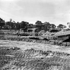
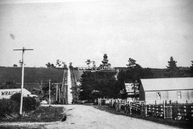
Negative - Photograph, J.A. McDonald, Eltham-Yarra Glen Road, Lower Plenty footbridge, Sep. 1955
... Eltham-Yarra Glen Road, Lower Plenty footbridge...Lower Plenty Road... the Plenty River is now known as Lower Plenty Road which becomes Main... the Plenty River is now known as Lower Plenty Road which becomes Main ...The Eltham-Yarra Glen Road as designated originated at the Shire of Eltham boundary at the Plenty River. West of the river the road was known as the Heidelberg-Eltham Road. The section from the Plenty River is now known as Lower Plenty Road which becomes Main Road. The footbridge no longer exists but was originally sited to the south, adjacent to the old Lower Plenty Bridge, now part of the Plenty River Trail. Record of various Shire of Eltham infrastructure works undertaken during the period of 1952-1962 involving bridge and road reconstruction projects, sometimes with Eltham Shire Council Project Reference numbers quoted. It was during this period that a number of significant improvements were made to roads and new bridges constructed within the shire that remain in place as of present day (2022). In many situations, the photos provide a tangible visible record of infrastructure that existed throughout the early days of the Shire. The album was put together by or under the direction of the Shire Engineer, J.A. McDonald.1955-09, eltham-yarra glen road, lower plenty footbridge, lower plenty, lower plenty bridge, lower plenty road, main road, plenty river trail, bridge construction, infrastructure, shire of eltham -
 Eltham District Historical Society Inc
Negative - Photograph, J.A. McDonald, Eltham-Yarra Glen Road, Lower Plenty footbridge, Sep. 1955
... Eltham-Yarra Glen Road, Lower Plenty footbridge...Lower Plenty Road... as Lower Plenty Road which becomes Main Road. The footbridge... as Lower Plenty Road which becomes Main Road. The footbridge ...Tony Carberry and J. Jolly The Eltham-Yarra Glen Road as designated originated at the Shire of Eltham boundary at the Plenty River. West of the river the road was known as the Heidelberg-Eltham Road. The section from the Plenty River is now known as Lower Plenty Road which becomes Main Road. The footbridge no longer exists but was originally sited to the south, adjacent to the old Lower Plenty Bridge, now part of the Plenty River Trail. Record of various Shire of Eltham infrastructure works undertaken during the period of 1952-1962 involving bridge and road reconstruction projects, sometimes with Eltham Shire Council Project Reference numbers quoted. It was during this period that a number of significant improvements were made to roads and new bridges constructed within the shire that remain in place as of present day (2022). In many situations, the photos provide a tangible visible record of infrastructure that existed throughout the early days of the Shire. The album was put together by or under the direction of the Shire Engineer, J.A. McDonald.1955-09, eltham-yarra glen road, lower plenty footbridge, j. jolly, lower plenty, lower plenty bridge, lower plenty road, main road, plenty river trail, tony carberry, bridge construction, infrastructure, shire of eltham -
 Eltham District Historical Society Inc
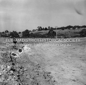
Negative - Photograph, J.A. McDonald, Reconstruction works, Lower Plenty Oval, Jan. 1961
3 February 1961 Looking towards Rattray RoadRecord of various Shire of Eltham infrastructure works undertaken during the period of 1952-1962 involving bridge and road reconstruction projects, sometimes with Eltham Shire Council Project Reference numbers quoted. It was during this period that a number of significant improvements were made to roads and new bridges constructed within the shire that remain in place as of present day (2022). In many situations, the photos provide a tangible visible record of infrastructure that existed throughout the early days of the Shire. The album was put together by or under the direction of the Shire Engineer, J.A. McDonald.1961-01, infrastructure, lower plenty oval, reconstruction works, shire of eltham -
 Eltham District Historical Society Inc
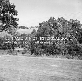
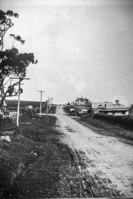
Negative - Photograph, J.A. McDonald, Eltham-Yarra Glen Road, Lower Plenty, c. July 1962
... Eltham-Yarra Glen Road, Lower Plenty...Lower Plenty Road...-07 Eltham-Yarra Glen Road Infrastructure Lower Plenty Lower ...View looking west across Old Eltham Road to the Eltham-Yarra Glen RoadRecord of various Shire of Eltham infrastructure works undertaken during the period of 1952-1962 involving bridge and road reconstruction projects, sometimes with Eltham Shire Council Project Reference numbers quoted. It was during this period that a number of significant improvements were made to roads and new bridges constructed within the shire that remain in place as of present day (2022). In many situations, the photos provide a tangible visible record of infrastructure that existed throughout the early days of the Shire. The album was put together by or under the direction of the Shire Engineer, J.A. McDonald.1962-07, eltham-yarra glen road, infrastructure, lower plenty, lower plenty road, road construction, shire of eltham, old eltham road -
 Eltham District Historical Society Inc
Slide - Photograph, Unidentified location, Eltham district, c.Aug. 1990
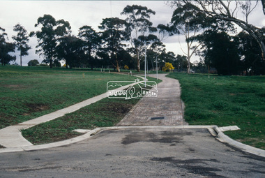
... then recently completed sections of the Main Yarra Trail at Lower Plenty ...Part of a presentation, "Roads and Byways of the Shire of Eltham", by Russell Yeoman to the 12 September 1990 Society meeting. Slides shown included copies of old photos and recent images ranging from the suburban streets of Eltham and Montmorency to the mountain roads of Kinglake. In the byways category are views of some iof the Shire's bicycle paths including then recently completed sections of the Main Yarra Trail at Lower Plenty.35mm colour positive transparency (1 of 37) Mount - Agfachrome Agfa CS System black 8 dotseltham, infrastructure, roads, unidentified -
 Eltham District Historical Society Inc
Slide - Photograph, Unidentified location, Eltham district, c.Aug. 1990
... then recently completed sections of the Main Yarra Trail at Lower Plenty ...Part of a presentation, "Roads and Byways of the Shire of Eltham", by Russell Yeoman to the 12 September 1990 Society meeting. Slides shown included copies of old photos and recent images ranging from the suburban streets of Eltham and Montmorency to the mountain roads of Kinglake. In the byways category are views of some iof the Shire's bicycle paths including then recently completed sections of the Main Yarra Trail at Lower Plenty.35mm colour positive transparency (1 of 37) Mount - Agfachrome Agfa CS System black 8 dotseltham, infrastructure, roads, unidentified -
 Eltham District Historical Society Inc
Slide - Photograph, Near the old Lower Plenty Bridge (present day Edward Willis Court), c.Aug. 1990
... . Infrastructure Roads Edward Willis Court Lower Plenty Lower Plenty Bridge ...Part of a presentation, "Roads and Byways of the Shire of Eltham", by Russell Yeoman to the 12 September 1990 Society meeting. Slides shown included copies of old photos and recent images ranging from the suburban streets of Eltham and Montmorency to the mountain roads of Kinglake. In the byways category are views of some iof the Shire's bicycle paths including then recently completed sections of the Main Yarra Trail at Lower Plenty.35mm colour positive transparency (1 of 37) Mount - Agfachrome Agfa CS System black 8 dotsinfrastructure, roads, edward willis court, lower plenty, lower plenty bridge -
 Eltham District Historical Society Inc
Slide - Photograph, Main Road, Eltham, c.1910, c.Aug. 1990
... then recently completed sections of the Main Yarra Trail at Lower Plenty ...Part of a presentation, "Roads and Byways of the Shire of Eltham", by Russell Yeoman to the 12 September 1990 Society meeting. Slides shown included copies of old photos and recent images ranging from the suburban streets of Eltham and Montmorency to the mountain roads of Kinglake. In the byways category are views of some iof the Shire's bicycle paths including then recently completed sections of the Main Yarra Trail at Lower Plenty.35mm colour positive transparency (1 of 37) Mount - Agfachrome Agfa CS System black 8 dotsinfrastructure, roads, main road, eltham -
 Eltham District Historical Society Inc
Slide - Photograph, Eltham-Yarra Glen Road, Kangaroo Ground c.1910, c.Aug. 1990
... then recently completed sections of the Main Yarra Trail at Lower Plenty ...Part of a presentation, "Roads and Byways of the Shire of Eltham", by Russell Yeoman to the 12 September 1990 Society meeting. Slides shown included copies of old photos and recent images ranging from the suburban streets of Eltham and Montmorency to the mountain roads of Kinglake. In the byways category are views of some iof the Shire's bicycle paths including then recently completed sections of the Main Yarra Trail at Lower Plenty.35mm colour positive transparency (1 of 37) Mount - Agfachrome Agfa CS System black 8 dotsinfrastructure, roads, eltham-yarra glen road, kangaroo ground -
 Eltham District Historical Society Inc
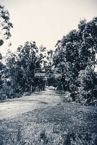
Slide - Photograph, Unidentified location, Eltham district, c.Aug. 1990
... then recently completed sections of the Main Yarra Trail at Lower Plenty ...Part of a presentation, "Roads and Byways of the Shire of Eltham", by Russell Yeoman to the 12 September 1990 Society meeting. Slides shown included copies of old photos and recent images ranging from the suburban streets of Eltham and Montmorency to the mountain roads of Kinglake. In the byways category are views of some iof the Shire's bicycle paths including then recently completed sections of the Main Yarra Trail at Lower Plenty.35mm colour positive transparency (1 of 37) Mount - Agfachrome Agfa CS System black 8 dotsinfrastructure, roads, houses, private street scheme, residential, unidentified -
 Eltham District Historical Society Inc
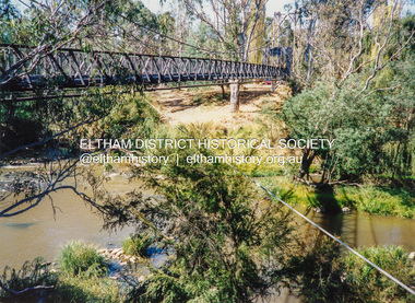
Photograph - Colour Print, Pedestrian suspension bridge over the Yarra River at Lower Plenty, c.1987
... Lower Plenty Odyssey House Seminary Yarra River Colour print ...blessed sacrament fathers, bonds road, bridge, footbridge, lower plenty, odyssey house, seminary, yarra river -
 Eltham District Historical Society Inc
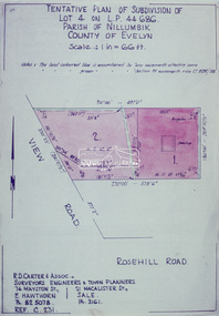
Slide - Photograph, Eltham Shire Council, Tentative Plan of Subdivision of Part of Lot 4 on L.P. 44 686, Parish of Nillumbik, County of Evelyn, 1969
... Rosehill Road Lower Plenty B3 Robinson prelim subdivision, View ...35mm colour positive transparency blue Agfacolour Service plastic mountB3 Robinson prelim subdivision, View Road, 4 August 1969infrastructure, map, planning, subdivison lots, view road, rosehill road, lower plenty -
 Eltham District Historical Society Inc
Photograph, Neville F. Emerson, Shoestring, Metery Road, Eltham, n.d
Stamped on reverse: Neville F. Emerson Estate Agent 81 Main Rd., Lower Plentyeltham, metery road, neville f. emerson real estate (lower plenty), shoestring, houses -
 Eltham District Historical Society Inc
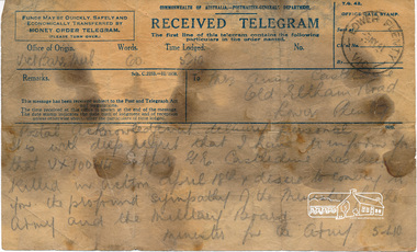
Telegram, Telegram, Victoria Barracks, Melbourne to Mrs Annie Castledine, Old Eltham Road, Lower Plenty, 3 May 1941, 3 May 1941
... Castledine, Old Eltham Road, Lower Plenty, 3 May 1941..., Melbourne to Mrs Annie Castledine, Old Eltham Road, Lower Plenty, 3 ..."Postal acknowledgement delivery personal" "It is with deep regret that I have to inform you that VX10044 Sapper G. E. Castledine has been killed in action April 18th & desire to convey to you the profound sympathy of the Minister for the Army and the Military Board. - Minister for the Army" Sapper George Ernest Castledine (1914-1941), son of Arthur Frederick and Annie Castledine, enlisted 23 January 1940 at Lower Plenty and was assigned to the 2/2 Field Company. He is buried in the Phaleron War Cemetery, Athens, Greece and is remembered on the Roll of Honour at Eltham.George was the first soldier from the Shire of Eltham to be killed in the Second World War. The telegram is oil stained as it was kept by George's brother Sid in his toolbox.Digital image of original held in private collection of Joan Castledine (niece of George Ernest Castledine and daughter of Sid and Polly (nee Arrowsmith) Castledine).Original bears oil stains from being stored in a tool box2/2 field company, aif, annie castledine, arthur frederick castledine, eltham war memorial, george ernest castledine, military, minister for the army, roll of honour, second word war, sid castledine, telegram -
 Eltham District Historical Society Inc
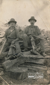
Photograph, Arthur Frederick Castledine (right) sitting on a wood pile towards the rear of their property, Araluen (southern end), Old Eltham Road, Lower Plenty, c.1930, 1930c
... Eltham Road, Lower Plenty, c.1930...araluen, arthur frederick castledine, lower plenty, old...Old Eltham Road, Lower Plenty, Victoria... Eltham Road, Lower Plenty, c.1930 Photograph ...Shows the men with rifles sitting on a wood pile out hunting for rabbits around the time of the Great DepressionDigital image of original held in private collection of Joan Castledine, daughter of Sid and Polly (nee Arrowsmith) Castledine, granddaughter of Arthur Frederick Castledine.araluen, arthur frederick castledine, lower plenty, old eltham road, rabbits -
 Eltham District Historical Society Inc
Folder, Pioneers & Painters; Shire of Eltham Historical Society research notes, background information, etc, 1969-1986, 1969-1986
... tice gellibrand lower plenty bridge m.b. watson main road map ...Material pertaining to the production of a history of the Shire of Eltham, "Pioneers & Painters: One Hundred Years of Eltham and its Shire" in recognition of the shire's centenary in 1971 Item Title Caption 04768-1 Newspaper clipping - The Eltham of 1905; Gellibrand our first white visitor? Diamond Valley News, 24 June 1969, p5 04768-2 Newspaper clipping - The Eltham of 1905; Gellibrand our first white visitor? Heidelberger, 25 June 1969 04768-3 Notes on Eltham District Road Board Members 1866-1871 04768-4 Notes on Eltham District Road Board Members 1866-1871 04768-5 Map showing Gellibrand's likely route through district 12-13 February 1836 and Hoddles's route of Febrary 1838 04768-6 Notes by Shire Secretary, M.B. Watson regarding meeting with Reverend Longfield regarding history of St Margaret's Church 04768-7 Alan Marshall's notes from discussion with Mr. F. Barrett regarding SEPP images 611, 635 and 636 SEPP_0611 SEPP_0635 SEPP_0636 04768-8 Transcripts of letter from local residents to Charles Joseph Latrobe requesting a bridge over the Plenty River dated 10 April 1849 and his reply dated 5 May 1849; from Latrobe Library Archives - Land Branch Records 04768-9 Notes on history of Eltham Shire, Centenary events and publication of Pioneers & Painters for release in conjunction of opening of new Library 04768-10 Newspaper clipping - Glossy record of shire's romantic past and the people who made it by Fab Calafuri, Diamond Valley News, Tuesday, December 16, 1986, p18 SEPP_0755-3 Letter: Acknowledgement from Colin J. Bock, Eltham Shire Secretary to A.R. Thomas of Bendigo for copy of 1913 photograph of Shire of Eltham Councilors, 21 May 1973 A.R. Thomas' father Mr. A.G. Thomas, C.E., was the Shire Secretary at the time in 1913. Cross Ref: SEPP_0755 The idea to develop a book on the history of the Shire of Eltham to be edited by noted author, Alan Marshall in celebration of the shire's centenary was initiated in 1969. The Shire of Eltham Historical Society undertook significant research in conjunction with Alan Marshall locating material at various institutions and other societies; interviewing longer term residents and a public campaign through the local press to acquire photographic material for duplication and use in the book. The public campaign received generous response and the material collected became the genesis for the Shire of Eltham Pioneers Photograph collection now held in partnership between Eltham District Historical Society and Yarra Plenty Regional Library (Eltham Library).Paper documents of various sizes and newspaper clippingsa.g. thomas, a.r. thomas, alan marshall, bridge road, charles joseph latrobe, council members, d.w. lachlan, eltham district road board, eltham shire council, ernie orford, f. barrett, francis rogerson, g. bransprone, james donaldson, james johnston, john bell, john thomson, joseph tice gellibrand, lower plenty bridge, m.b. watson, main road, map, patrick turnbull, peter morris, pioneers and painters, post office, rev. longfield, sepp, shire of eltham pioneers photograph collection, shire secretary, st margaret's church, thomas armstrong, thomas bell, thomas sweeney, william bell (1796-1870), centenary celebrations, christmas hills, clifton pugh, david newbury, dudley street, eltham, gareth jones roberts, hurstbridge, john perceval, joy peck, kangaroo ground, kinglake, lower plenty, luther haley general store, montmorency, neil douglas, panton hill, peter glass, research (vic.), sheila ferguson, shire of eltham, st andrews, yarra glen -
 Eltham District Historical Society Inc
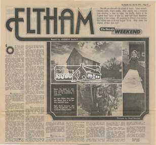
Newsclipping, Eltham, Report by Andrew Mckay, Pictures by Noel Butcher, The Herald, 26 July 1975, pp 21-22, 26 Jul 1975
... , Lower Plenty, Marcus Skipper, Matcham Skipper, Montmorency..., Lower Plenty, Marcus Skipper, Matcham Skipper, Montmorency ...Digital file only - Digitised by EDHS from a scrapbook on loan from Beryl Bradbury (nee Stokes), daughter of Frank Stokes.alistair knox, alma road, arthur munday, beryl bradbury (nee stokes) collection, cameron jackson, carina hack, charlie macgillicuddy, charlie stevenson, circus, clifton pugh, david stephens, dorian le gallienne, eltham, eltham college, eltham hotel, eltham living and learning centre, eltham town square, eltham village, george paul, graham bell, great hall, green wedge, harold holt, jazz, jim chinaman's road, justus jorgensen, kangaroo ground, lower plenty, marcus skipper, matcham skipper, montmorency, montsalvat, mud brick construction, mudbrick, myra skipper, professor dick downing, professor macmahon ball, professor richard downing, research (vic.), roger bell, shire of eltham, shire president, shopping centre, swiper's gully, tim burstall, white cloud cottage -
 Eltham District Historical Society Inc
Newsclipping, Glossy record of shire's romantic past and the people who made it by Fab Calafuri, Diamond Valley News, 16 September 1986, 16 Sep 1986
A review of Pioneers and PaintersDigital file only - Digitised by EDHS from a scrapbook on loan from Beryl Bradbury (nee Stokes), daughter of Frank Stokes.beryl bradbury (nee stokes) collection, pioneers and painters, alan marshall, centenary celebrations, christmas hills, clifton pugh, david newbury, dudley street, eltham, gareth jones roberts, hurstbridge, john perceval, joy peck, kangaroo ground, kinglake, lower plenty, luther haley general store, main road, montmorency, neil douglas, panton hill, peter glass, research (vic.), sheila ferguson, shire of eltham, shire of eltham pioneers photograph collection, st andrews, yarra glen