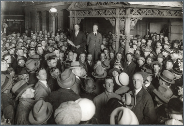
Showing 180 items matching "thomas grant"
-
 Bendigo Historical Society Inc.
Document - DELL CAFÉ, RE-UNION DINNER, 29 March, 1947
Dell Café, Re-Union Dinner. Employees of the Old Firm D Whyte & Co. First Annual Re-Union Dinner, Saturday, 29th March, 1947. Dell Café, Hargreaves St. Bendigo. President: T D Cairns, Hon. Sec: J Swatton. Program includes singing and music. Record of Service, name and years of service of employees. R F Gray, T D Cairns, Geo Bennett, H Kerr, F Owen, W McCoy, W Hampton, W Chapmon, G Glover, J Guidice, P Williams, T Mills, K Swift, G O'Donnell, T Chalkey, C Lee, J Swatton, P Read, A Keast, L Rowe, J Richards, T Thompson, Clem Hicks, J Ash, M McDonald, P Burns, W Durwood, P Gouglin, S Clarke, H Colee, J Cox (Jack), S Davey, J Cox (Joe), H Francis, D Grant, E A Hargreaves, H Heggie, J Hicks, R Johnson, H Maybury, J Mead, J Murphy, Gus Lynch, R Nankervis, W Webster, F Wittscheibe, C Watson, R Veal, H Shuttleworth, T Edwards, P Seeber, W Beckerleg, R Huillier, Geo Hall, Les Maher, H Sims, B Patterson, M Clarke, H Robotham, T Lansell, W A McCawley, J Boland, W Gardiner, J Graham, B Stephenson, A Rowe, Geo Nevinson, J Loddington, V Thomas, F Swatton, C Eddy, D Sterry, A Warren, J Lych, Miss Liddy, Miss L Guest. 4 pages.Cambridge Press, Bendigoevent, social, dell café, dell café, re-union dinner. employees of the old firm d whyte & co. first annual re-union dinner, saturday, 29th march, 1947. hargreaves st. bendigo. president: t d cairns, hon. sec: j swatton. program includes singing and music. record of service. r f gray, t d cairns, geo bennett, h kerr, f owen, w mccoy, w hampton, w chapmon, g glover, j guidice, p williams, t mills, k swift, g o'donnell, t chalkey, c lee, j swatton, p read, a keast, l rowe, j richards, t thompson, clem hicks, j ash, m mcdonald, p burns, w durwood, p gouglin, s clarke, h colee, j cox (jack), s davey, j cox (joe), h francis, d grant, e a hargreaves, h heggie, j hicks, r johnson, h maybury, j mead, j murphy, gus lynch, r nankervis, w webster, f wittscheibe, c watson, r veal, h shuttleworth, t edwards, p seeber, w beckerleg, r huillier, geo hall, les maher, h sims, b patterson, m clarke, h robotham, t lansell, w a mccawley, j boland, w gardiner, j graham, b stephenson, a rowe, geo nevinson, j loddington, v thomas, f swatton, c eddy, d sterry, a warren, j lych, miss liddy, miss l guest -
 Bendigo Historical Society Inc.
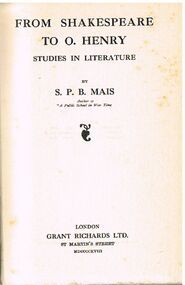
Book - ALEC H CHISHOLM COLLECTION: BOOK ''FROM SHAKESPEARE TO O.HENRY'' BY S.P.B.MAIS
Book. ALEC H CHISHOLM COLLECTION. 313 page hardcover book of studies in literature by S. P. B. Mais. Features authors such as Samuel Butler, John Masefield, Rupert Brooke, O. Henry and Thomas Hardy. Published in 1918 by Grant Richards Ltd, London and printed by Riverside Press, Edinburgh. Catalogue sticker ''2163 MAI'' on spine.S. P. B. Maisbooks, collections, poetry, alec h chisholm collection, s.p.b.mais, literature, poetry -
 Bendigo Historical Society Inc.
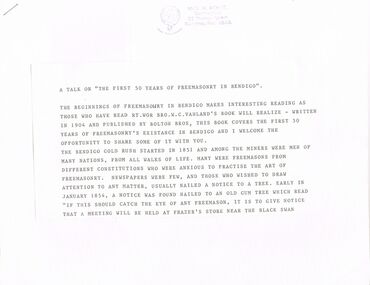
Document - TEXT OF TALK: THE FIRST 50 YEARS OF FREEMASONRY IN BENDIGO
TEXT OF TALK - ''THE FIRST 50 YEARS OF FREEMASONRY IN BENDIGO''. (Stamped on first and last page with name of Mc.G W Morse 'Dunmaghlas' 36 Thomas St, Kangaroo Flat. (author?; no date provided). Typed pages cut and mounted on 17 stapled pages. References to: W C Vahland; ''The Golden Lodge of Bendigo''; organ; Corinthian Lodge of Sandhurst; ''Black Liners''; Eaglehawk Lodge; Zenith Lodge; Golden and Corinthian Lodge; Art Union; Masonic Charity Sunday; Sandhurst Lodge; Corona Lodge; Royal Golden Chapter; Kinghts Templar; Mark Master Masons Degree;mcG. W. Morse, Dunmaghlas, 36 Thomas Street Kangaroo Flat. 3555clubs, social, freemasonry, bro. w.c. vahland, boltons brothers, bendigo gold rush, freemasons, brother r.c. mackenzie, criterian hotel, brother w. scott, brother edward salaman, grant's cafe. -
 Bendigo Historical Society Inc.
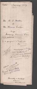
Document - CONNELLY, TATCHELL, DUNLOP COLLECTION: MORTGAGE DOCUMENT ALBION THOMAS MILLER TO THOMAS LUXTON
Mortgage document and associated letters- mortgage dated 11th. January, 1889, number 3103. Mr. A.T. Miller to Mr. Thomas Luxton. Draft Mortgage to secure 500 pounds and interest. Mortgage crown grant allotment 16 Sec 97C Sandhurst delivered to Luxton 25/1/89. Albion Thomas Miller, McCrae Street, Sandhurst, was a produce dealer.cottage, miners, albion thomas miller, thomas luxton, mortgage, produce dealer, sandhurst. -
 Victorian Interpretive Projects Inc.
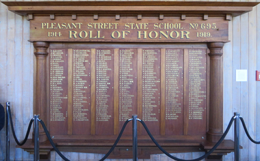
Photograph - Colour, Mount Pleasant State School Honour Board
Photograph of a timber honour boardworld war one, world war, mt pleasant state school, honour board, barnett, mcgregor, gribble, pollock, ross, jolly, sargeant, eggington, jerram, frank, hind, lingham, king, may, renfree, chandler, wight, zilles, matthews, slater, rowsell, hallett, peice, simpson, webb, coffet, tobert, buchanan, burrows, brazenor, cochrane, macdonald, ottaway, smith, o'bern, ware, treloar, saxton, wilson, stark, greenwood, orr, nankervis, burge, rooney, hoskin, bell, dunstan, craig, pattie, carroll, moon, bieske, page, richards, lockett, collett, frampton, williams, symonds, mcdonald, hicks, selmon, britton, martell, bolton, westcott, simper, cowdell, doepel, commons, hooley, gates, campbell, martin, neville, aikins, price, jeffree, rogers, murrie, fraser, cunningham, gedling, zazzard, malcolm, thomas, spears, hyland, pascoe, davis, peters, martnell, hill, reynolds, parkin, dobson, pope, stratford, scott, preston, adamson, lucas, bailey, jones, wrigley, morrell, gullan, provis, semmens, whittle, falla, gluyas, barrett, berryman, carincross, twaits, porter, heard, edwards, hand, robb, grant, bishop, dean, graham, mcallester -
 Creswick Museum
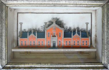
Model Building, circa 1869
Rev. Thomas Williams was grandfather of the Lindsay children. He is credited with encouraging his grandchildren in their artistic talents. Both Lionel and Normam learnt their model making skills from him. Creswick Hospital was foundation stone was laid in 1863. It operated as a hospital until 1911 when it was sold to the government as part of the School of Forestry (now University of Melbourne). The model shows it as a red brick building. In the 1870s it was painted as a white building. The Museum has b/w photos of the building taken prior to rendering. The people of Creswick collected fund for the project and obtained a government grant. The 1857 survey map of the proposed township shows the area at Eastern Hills reserved for a hospital and Benevolent SocietyThe model's unique association with the Lindsay Artist of Creswick. Model of Creswick Hospital before rendering. Made of paper with painted background and framed.model, creswick hospital, rev t. williams, lindsay family -
 Bendigo Historical Society Inc.
Document - THE MEUDELL MYSTERY
George Meudell was born in Bendigo in 1860, the son of a bank manager. He became a public accountant. He worked for B J Fink. He took up a seat on the Stock Exchange. He later wrote a book, 'The Pleasant Career of a Spendthrift'. The book caused a stir and was withdrawn from sale. There was a later edition where a lot of names were withdrawn from the book.document, names of bendigo pioneers, the meudell mystery, the land boomers, michael cannon, maurice brodzky, george meudell, table talk, bendigo high school, money miller's bank of victoria, grant meudell, hnry miller, isaac pitman, john alsop, melbourne savings bank, andrew lyell, mercantile finance co ltd, b j fink, g w taylor, thomas bent, w l baillieu, stock exchange melbourne, william knox, broken hill proprietary, f m dickenson, historical society of victoria, the pleasant career of a spendthrift, george routledge & sons ltd, routledge & kegan paul ltd, frank campbell, robertson & mullens ltd, j m gillespie, sir matthew davies's mercantile bank, unofficial history of victoria, booksellers' association, the pleasant career, theodore fink, the herald, wilke & co pty ltd, the pleasant career of a spendthrift and his later reflections, lionel robinson, william clark, s m bruce, premier building society, j kitchen & sons ltd -
Tatura Irrigation & Wartime Camps Museum
Legal Documents, Obituary of Thomas Hogan, 1927 -1945
Legal documents re the will of Thomas HoganLegal documents in buff coloured legal envelope with number "561" and "Hogan - Thomas dec'd" written in green on front. Documents regarding the estate of Thomas Hogan including:|Bankruptcy proceedings of John Micheal Hogan and discharge dated 23/9/1945|Indenture dated 19/5/1927|Creation of Easement on crown allotments 102 & 103 granted to S.R. & W.S.C. dated 5/6/1929|Lease agreement dated 23/12/1930|Lease agreement dated 30/5/1932|Indenture dated 20/5/1927|Indenture dated 31/10/1935|Indenture dated 8/4/1932|Indenture dated 13/7/1927|Indenture dated 24/3/1932|Indenture dated 12/4/1932|Creation of Easement on crown allottment 103 granted to Loo Way and Ah Poy dated 23/12/1929documents, legal, leases -
 Williamstown High School
Form 2B 1946
Copy of black and white photograph mounted on card.Form 2B - Williamstown High School 1946. Back row: Graham Thomas, Gordon Bird,Frank Ranger,Geoff Boyes, Richard Anthony,Leon Hopkins, Alan Chandler. Second row: Peter Machin, Alistair McLeman, Peter Constable, Bob Gerring, Milton Stone, George Pickering, Max Stephens, Norman Basford. Third row: Valda Welsford, Jean Grant, Pam Trask, Eileen Williamson, Audrey Sinclair, Norma Caple, Heather Neish, Shirley Hansen, Mr Tuck. Fourth row: Merle Valentine, Margaret Stubbs, Shirley Spicer, Carol Crowder, Loan Davis, Jean Spencer, Joyce Hickox. Front row: Ivan Nicholls, Kevin Neal, Ivan Quinn. Donated by Bob Gerring. 4th from left, second top row.williamstown high school, form 2b, 1946 -
 City of Ballarat
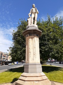
Sculpture - Public Artwork, George Grant, Thomas Moore Memorial Statue George Grant, 1889
Irish poet and balladeer Thomas Moore, best-known for penning The Minstrel Boy and The Last Rose of Summer, is honored in this statue prominently located in Sturt Street created by sculptor George Grant from white Carrara marble. George Grant was trained at the School of Art associated with the National Gallery of Victoria, apparently in the 1880s, and then worked as an artist, specialist house painter, and banner artist. Several of his paintings are held by the Ballarat Art Gallery. Moore`s writings range from lyric to satire, from prose romance to history and biography. His popular "Irish Melodies" appeared in ten parts between 1807 and 1835. Moore was a good musician and skillful writer of songs, which he set to Irish tunes, mainly of the 18th century. This statue is of historic and aesthetic significance to the people of Ballarat.Marble statue of Thomas Moore above a large sandstone pillar West: Presented to the City Council of Ballaarat by the following citizens: H.F. Elliot, The Honorable E. Morey M.L.C., Cr C.R. Retallick, Cr J. Heinz. South: R.S. Mitchell, P. Papenhagen, T. Elliot, J. Snow, G.K. Coutts, C. Bailey, J.J. Goller & Co, W.E. Ballhausen, G. Thompson, W.H. Figgis. North: S. Seward, F.G. Haymes, Craig Williamson, R. Giddings, G. Berry, R. Inge, J.A. Pittard, L. Lederman, H. Bremer, D. Jones. thomas moore -
 National Wool Museum
Knife
Bowie knife, presented to or ordered by Charles John Dennys. Charles John Dennys (1818-1898) arrived from England in 1842 and set up a wool-broking business in 1852 with his cousin Thomas Allen Lascelles and Edward Walton. This became Dennys, Lascelles Ltd and later Dennys, Lascelles, Austin and Co. after prominent grazier Sidney Austin joined the firm in 1881. Dennys was appointed Secretary of the District Council of Grant in 1843 and was elected to the South Barwon municipal council in 1857 ("The Bay, Barwon and Beyond", pp.12-13). The donor is the great grand daughter of Charles Dennys; she found the knife whilst cleaning out an aunt's house and has no knowledge of its provenance. Many bowie knives were exported to America from Sheffield, where a number of manufacturers began making them in the 1800s. This style of knife dates typically from the mid 1800s.Bowie knife made by Morton & Davis, Sheffield and owned by Charles John Dennys (1818-1898), co-founder of the woolbroking firm Dennys, Lascelles Ltd. Bowie knife made by Morton & Davis, Sheffield and owned by Charles John Dennys (1818-1898), co-founder of the woolbroking firm Dennys, Lascelles Ltd.STANLEY / MORTON & DAVIS / CELEBRATED BOWIE KNIFE / SHEFFIELD ASK FOR NOTHING / BUT what is / RIGHT / SUBMIT TO NOTHING THAT IS / WRONG CHARLES JOHN DENNYS.dennys, mr charles john -
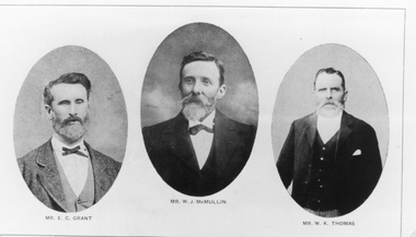 Stawell Historical Society Inc
Photograph, St Matthews Presbyterian Church with Mr E C Grant, Mr W.J. McMullin, Mr W.K. Thomas -- 3 Photos
... E.C. Grant. W.J. McMullin. W.K. Thomas (Presbyterian) the 3... grampians E.C. Grant. W.J. McMullin. W.K. Thomas (Presbyterian ...E.C. Grant. W.J. McMullin. W.K. Thomas (Presbyterian) the 3 photos copied from Jubilee History 1860 -1911 St Matthews Presbyterian (Church Stawell). The Jubilee History was printed and taken from The Times, Main St. Stawell. Mr. E.C. Grant was Treasurer for 29 years. A tablet placed on the wall above the vestry door to perpetuate the memory of Mr. E. C. Grant, one of the greatest benefactors the church ever had. The inscription reads: In memoriam/ erected by the congregation of St Matthew's/ in memory of / The Stirling worth of / Edmund Craigie Grant/ who died 4th July 1894/ aged 63 years. He was a sincere Christian/ A most Liberal & generous giver/ and a true lover of his kind. / Well done good, and faithful servant Matthew XXV. v23. Mr. W.J. McMullin was a secretary of the Sabbath School - later became superintendent a position he held for 26 years. Up to the time of his death - Faithfully discharged his duties. Mr. W.J. McMullin had the distinction of serving as an elder for 26 years from 1883 until the time of his death in 1909. Mr. W.K. Thomas was leader of the choir which he conducted for 21 years - until his death 1901. Black & white photographs of oval shaped portraits of gentlemen. An enlargement is made of each individual. The gentlemen are formally dressed.Mr. E.C. Grant, Mr. W.K. Thomos, Mr. W.J. McMullin.stawell portrait -
 Whitehorse Historical Society Inc.
Document, Nunawading, ?1995
Photocopy of search notes summarising memorials relating to part Crown Portions 80,81,82,89,90 and 91 originally granted to John Woods, 31 March 1855 and transferred to Frederick Walter Purches, Edwin James Purches, George Seth Coppin, Freehold Investment and Banking Co of Australia and Australian Deposit and Mortgage Bank; with page listing titles derived from Freehold Investment and Banking Co of Australia Limited 1889 - 1890.non-fictionmorton thomas richards burrowes -
Whitehorse Historical Society Inc.
Letter - Correspondence, Letter regarding Silver Jubilee medal, 29/04/1935
Letter from Government House to Herbert Thomas Bishop informing him that the King has granted him a medal in commemoration of the 25th anniversary of his accession to the throne.bishop, herbert thomas, governors, medals -
Whitehorse Historical Society Inc.
Document, Crown Grant Register, 10/05/1999
Crown Grant Register - General Law - Parish of Nunawading, 1854 - 1858. Lands Department plan of Parish, 1864.land settlement, victoria. lands department, blood, robert, blood, thomas, burrell, charles, clisby, william, cook, charles, cousens, james, dickensen, william, harding, william, hedding, william, holland, john, jones, william, kefford, richard, lobb, john, morgan, robert rowland, morton, william, o'conner, patrick, orr, joseph, polak, nelson, riley, patrick, smith, l l dr, tranter, william, whitman, francis, williams, william, wilks, joseph, wilson, william, wilton, edward -
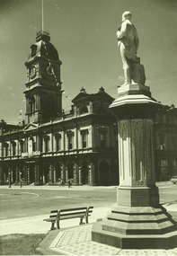 City of Ballarat Libraries
Photograph, Thomas Moore statue, and Town Hall, Sturt St, Ballarat
... by members of the Ballarat Camera Club in September 2006. Thomas ...An image from the Herbert Richmond collection, gifted in 1982 to the Ballarat Library. The collection contains approximately 200 photographs of Ballarat and district in the 1940s, 50s and 60s, as well as photo albums, glass negatives and other memorabilia. Herb Richmond was a keen photographer, a foundation member and a life member of the Ballarat Camera Club, and a photographer with the Ballarat Courier during the 1940s. The Ballarat Camera Club named an annual award after him. Mr Richmond died in 1981 aged 79. These images were digitally re-photographed by members of the Ballarat Camera Club in September 2006. Thomas Moore was an Irish poet, the inspiration for this statue coming from the Irish people of Ballarat, soon after the Robert Burns statue was erected by the Scots. Sculpted by George Grant in 1889moore, thomas, begonia festival -
 Bendigo Historical Society Inc.
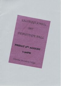
Document - PETER ELLIS COLLECTION: KALIANNA SCHOOL DEBUTANTE BALL, 3rd August, 2007
Program for the Kalianna School Debutante Ball held on Friday 3rd August 2007 at the Weerona Secondary College. Program is light grey with a purple sticker on an angle with the name on it. On white paper on the inside is the names of the debutantes and their partners and who they were presented to, Master of Ceremonies & Deb Set Co-ordinator, Chaperones, Compares, Music by Emu Creek Band, Flower Girl and Page Boy. Pasted on the back is a matching grey card thanking businesses and people who helped. Names are: Cr Kevin Gibbons, Debbie Gibbons, Lindy & William Lupo, Alison & Geoff Byron, Leon Scott, Debbie Price, Peter Burch, Cherryl Fyffe, Leon Scott, Emu Creek Band, Rebecca Nelson, Caleb Richardson, Charmaine Scown, Alicia Owen, Jessica Brereton, Nikita Riordan, Laura Semmens, Rebecca Apps, Chloe Gruber, Lauren Hawken, Amanda Anderson, Victoria Jelbart, Rachell Sutherland, Amy Roberts, Sally McMurtrie, Chevonne Strauch, Ben Holmes, Dean Snelson, Zac Flint, Tamati Poindestre, Brandon Kelly, Paul Drinkell, Adrian Brown, Chris Oojges, David Boyce, Josh Rosewall, Michael Semmens, John Wiktorek, Kane Wojcicki, Matthew Mitchell, Hairem Scarem, Grant Rule Menswear, Sean Walsh Photography, Mary Smith (Plant Exhibits), Anne Hastings (Deb Ball Seamstress), Debbie Price, Tracey Wojcicki, Glenys Jelbart, Pam Holmes, Rae Hall, Samantha Wearne, Kylie Salter, Cathy Brew, Judy Richards, Aileen Gilbee, Marie Loch, Noel & Lorna Thomas, Ron & Janette Moss, Tracey & Peter Wojcicki, Val & Neil Cartledge, Warwick Strauch, Kevin Salter, Grant King, Kay Tamblyn and Christine Smith.Weerona Secondary Collegeentertainment, dance, ball, peter ellis collection, kalianna school, weerona secondary college, cr kevin gibbons, debbie gibbons, lindy & william lupo, alison & geoff byron, leon scott, debbie price, peter burch, cherryl fyffe, leon scott, emu creek band, rebecca nelson, caleb richardson, charmaine scown, alicia owen, jessica brereton, nikita riordan, laura semmens, rebecca apps, chloe gruber, lauren hawken, amanda anderson, victoria jelbart, rachell sutherland, amy roberts, sally mcmurtrie, chevonne strauch, ben holmes, dean snelson, zac flint, tamati poindestre, brandon kelly, paul drinkell, adrian brown, chris oojges, david boyce, josh rosewall, michael semmens, john wiktorek, kane wojcicki, matthew mitchell, hairem scarem, grant rule menswear, sean walsh photography, mary smith (plant exhibits), anne hastings (deb ball seamstress), debbie price, tracey wojcicki, glenys jelbart, pam holmes, rae hall, samantha wearne, kylie salter, cathy brew, judy richards, aileen gilbee, marie loch, noel & lorna thomas, ron & janette moss, tracey & peter wojcicki, val & neil cartledge, warwick strauch, kevin salter, grant king, kay tamblyn, christine smith -
 Bendigo Historical Society Inc.
Document - JOHN JONES COLLECTION: BACK TO MANDURANG SOUVENIR 1938
Photocopies and original of 'Back to Mandurang' Souvenir. Celebration 1938. Contains the history of Mandurang and many of the local residents, the industries and agricultural pursuits. Names mentioned are: Mrs Thomas, Les Nankervis, Geo McGuire, Pinche, Mr Coghill, Mr Fenton, Atkinson's Station, John T Deravin, Wine Hall, Church, Kerr's Hotel, Tannery, Mr Panton, John Billman, Sheepwash Creek, Emu Creek, Port Phillip District (Victoria), Mr Charlesworth, Sam Snowden, Mr Grant, Grant's Land Act, Mr Montgomery, Mr McEncroe, Mr Wyeland, John Smith, Mr Adams, Geo Kofoed, Monti, Mr Ewing, Wm Ewing, Geo Green, Jim Green, Green Bros, Wm Keating, Mandurang Hotel, J B Loridan, Mr Lansell, 'General Grant', August Heine, Mr Myers, Mr Barth, Phylloxeria, Mr Jones, Mr McGuire, James Hargreaves, Mr Bounty, E Huillier, Sam Martin, Mr Oldworth, Dr Backhaus, Andrew Monti, W Wenwright, Mr Munroe, Mr Eldridge, Wm Wright, W Thomas Lowe, Taylor, Sam Lowe, George Lowe, Wm Hargreaves, Albert E Pearce, Piccaninny Creek, G Sherriff, Mr Stein, Albert Stein, John Theodore Deravin, Robins, Phylloxera vastrix, Mr Grosse, Board of Health, Chateau Dore, House of Assembly, Dr Hugh Deravin, Mrs Deravin, John Adolphus Deravin, Education Department, Bendigo High School, St Andrew's College, Stock Exchange, Relief Funds, L Dungey, Mr Crawford, A W McCauley, Schillerio, Cleghorn, Goudge and Sibley, Sibley and Lambert, R H S Abbott, Protestant Church, Miss E Wright, W Stephenson, Geo Lowe, J Hargreaves, Theo Deravin, Wm Pearce, Mrs A Deravin, St John's Roman Catholic Church, Father O'Connell, Father McKnab, Post Office, I Witworth, W Casey, Franz Steilow, Geo Billman, R Brennan, F Osborne, Mr Webster, Wm Hughes, Mr Raymond, One Tree Hill, Jerry Ryan, Bendigo City, Shire of Strathfieldsaye. Original copies are very dilapidated and pages 6, 7, and 8 are missing. (In 5 pockets).ephemera, mementoes, back to mandurang, john jones collection - back to mandurang souvenir 1938, mrs thomas, les nankervis, geo mcguire, pinche, mr coghill, mr fenton, atkinson's station, john t deravin, wine hall, church, kerr's hotel, tannery, mr panton, john billman, sheepwash creek, emu creek, port phillip district (victoria), mr charlesworth, sam snowden, mr grant, grant's land act, mr montgomery, mr mcencroe, mr wyeland, john smith, mr adams, geo kofoed, monti, mr ewing, wm ewing, geo green, jim green, green bros, wm keating, mandurang hotel, j b loridan, mr lansell, 'general grant', august heine, mr myers, mr barth, phylloxeria, mr jones, mr mcguire, james hargreaves, mr bounty, e huillier, sam martin, mr oldworth, dr backhaus, andrew monti, w wenwright, mr munroe, mr eldridge, wm wright, w thomas lowe, taylor, sam lowe, george lowe, wm hargreaves, albert e pearce, piccaninny creek, g sherriff, mr stein, albert stein, john theodore deravin, robins, phtlloxera vastrix, mr grosse, board of health, chateau dore, house of assembly, dr hugh deravin, mrs deravin, john adolphus deravin, education department, bendigo high school, st andrew's college, stock exchange, relief funds, l dungey, mr crawford, a w mccauley, schillerio, cleghorn, goudge and sibley, sibley and lambert, r h s abbott, protestant church, miss e wright, w stephenson, geo lowe, j hargreaves, theo deravin, wm peatce, mrs a deravin, st john's roman catholic church, father o'connell, father mcknab, post office, i witworth, w casey, franz steilow, geo billman, r brennan, f osborne, mr webster, wm hughes, mr raymond, one tree hill, jerry ryan, bendigo city, shire of strathfieldsaye -
 Bendigo Historical Society Inc.
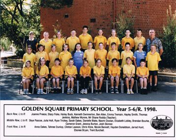
Photograph - GOLDEN SQUARE LAUREL STREET P.S. COLLECTION: PHOTOGRAPH - GSPS YEAR 5-6/R 1998
Coloured photograph of the Golden Square Primary School, Year 5-6/R, 1998. Children are wearing school uniform. Their names are: Back Row, L to R: Joanne Preece, Stacy Fiske, Hailey Buck, Kenneth Swinnerton, Ben Allen, Emma Tremain, Hayley Smith, Thomas Jenkins, Mathew Wynne, Mr Shane Rodda (Teacher). Middle Row, L to R: Skye Pascoe, Julia Holt, Ryan Trickey, Sarah Oakes, Danielle Blake, Naomi Doolan, Elizabeth Lobley, Brendan Bourke, Cameron Grant, Jessica Burton, Josh Skinner. Front Row, L to R: Anna Oakes, Tahnee Dunlop, Clinton Lawson, Chris Kline, Nicole Bennett, Hayden Donaldson, Jarrad Hunt, Ebonee Bryan, Trent Burchell. Oval sketch of the school to the right of the names.education, primary, golden square laurel st p.s., golden square laurel street p.s. collection - photograph - golden square primary school year 5-6/r 1998, joanne preece, stacy fiske, hailey buck, kenneth swinnerton, ben allen, emma tremain, hayley smith, thomas jenkins, mathew wynne, mr shane rodda (teacher), skye pascoe, julia holt, ryan trickey, sarah oakes, danielle blake, naomi doolan, elizabeth lobley, brendan bourke, cameron grant, jessica burton, josh skinner, anna oakes, tahnee dunlop, clinton lawson, chris kline, nicole bennett, hayden donaldson, jarrad hunt, ebonee bryan, trent burchell -
 Bendigo Historical Society Inc.
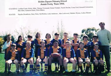
Photograph - GOLDEN SQUARE LAUREL STREET P.S. COLLECTION: PHOTOGRAPH - GSPS AUSSIE FOOTY TEAM 1996
Coloured photograph of the Golden Square Primary School Aussie Footy Team 1996. The front row are seated on chairs and the back row are standing behind them. One boy has his are in a sling. Their names are: Standing: Lachlan Carter, Kristy Allen, Thomas Townsend, Emma Tremain, Naomi Doolan, Corey Ford, Kenneth Swinnerton, Ben Allen, Cameron Grant, Chris Ohlson. Seated: Hayden Donaldson, Stacy Fiske, Seb Robins, Luke Anderson, Alex Lockwood, Mathew Wynne, Joshua Skinner.education, primary, golden square laurel st p.s., golden square laurel street p.s. collection - photograph - gsps aussie footy team 1996, lachlan carter, kristy allen, thomas townsend emma tremain, naomi doolan, corey ford, kenneth swinnerton, ben allen, cameron grant, chris ohlson, hayden donaldson, stacy fiske, seb robins, luke anderson, alex lockwood, mathew wynne, joshua skinner -
 Bayside Gallery - Bayside City Council Art & Heritage Collection
album - album containing photographs and documents, Album recording the results of the by-election for the District of Brighton, 1928, 1928
This album records the counting of votes for the Member of the Legislative Assembly for the Electoral District of Brighton at the Brighton Town Hall on 28 April 1928. The byelection took place to fill the seat caused by the death of Mr. Snowball. The candidates were Henry Armitage Abbott, William Fyfe Finlayson, Henry Earnest Hall, Martin Hannah, Daniel James Hoban, Alured Kelly, Ian MacFarlan, James Morrison Ramsay, Thomas Ryan. Due to there being no absolute majority, the counting of preferential votes to eliminate defeated candidates took place. Ian MacFarlan was elected as Member for the district. byelection, election, district of brighton, legislative assembly, henry armitage abbott, william fyfe finlayson, henry earnest hall, martin hannah, daniel james hoban, alured kelly, ian macfarlan, james morrison ramsay, thomas ryan, j.a. taylor, j.a. grant, town clerk, brighton town hall -
 Bayside Gallery - Bayside City Council Art & Heritage Collection
Photograph - sepia photograph, Gainsborough studios, Members of Brighton District Brass Band, 1915
This framed compilation was presented to Councillor Thomas Wilson J.P., President and Trustee, by the Members & Committee of the Brighton District Brass Band as a token of esteem on 23 September 1915.brighton district brass band, band, brass band, councillor, committee, members, w.a. adamson, d.e. mcbryde, cr. g.h. alford, cr. j.j. hanby, cr. t. wilson, cr. w.p. frances, cr. j.r. burrows, j.h. taylor, d. bridgen, h.l. glenn, g. sheppard, d. mcpherson, w. octagon, h.r. wonnacott, w. booker, j. grundy, e. sangwell, h. teeson, c. dunham, w. lawrence, l. blight, h. leftley, g. rumney, f. monk, j.j. passe, a.e. brown, h.j. thorns, n.l. orford, a. grant, j. monk, w. graham, g. nickells, c. temme, h.f. northe, e. harding, g. reed, w. mason, w. lott, h. cooper, j. eldred, h. holmes, a. brame, sepia photograph, portrait, gainsborough studios -
 Bayside Gallery - Bayside City Council Art & Heritage Collection
Photograph - gelatin silver photograph, Council meeting, Brighton Town Hall, 1 March 1933, 1933
council, meeting, brighton, town clerk, councillor, reporters, press table, elizabeth bleazby, city engineer, g. woodward, hallkeeper, c.e. tuxen, j.h. taylor, mayor, portrait, thomas bent, local government, brighton town hall, cr. j.a. grant, cr. f.e. rogers, cr. a.r. horton, cr. a. giles, cr. e. bleazby, cr. j.v. satchwell, cr. j.a. kennedy, cr. h.e. hall, cr. e.m. young, cr. r. eustace tracey, cr. j. redapple -
 Bayside Gallery - Bayside City Council Art & Heritage Collection
Photograph - sepia photograph, City of Brighton Mayor, Councillors and Officers - Peace & City Year - August 1919, 1919
brighton, council, mayor, councillors, officers, brighton town hall, t. vincent, park ranger, j.n. clark, overseer, f. blackham, press, r.j. lawrence, bank manager, a. vogt, assistant, j. clementson, inspector, l.w.p baker, assistant town clerk, g.w. woodward, hallkeeper, g. marsh, curator, a.f. magill c.e., city engineer, w. turner, cr. w.e. briggs, dr w.c. mcclelland, health officer, cr c.h.j. pickett, c.h. livesey, rate collector, cr j.a. grant, cr. j.w. satchwell, cr p.a. oakley, j. ritson, librarian, cr c.a. hack, cr j. richards, cr h.e. hall, cr t. wilson, j.h. taylor, town clerk, cr. w.p. francis, cr j.b. grout j.p., cr h.e. pullman, g.h. jefferson, solicitor, miss d.m. grout, typist, d. thomas, office boy, peace and city year -
Kew Historical Society Inc
Journal, Kew Historical Society, Newsletter No.126, March 2019
Embroidering a Theme / Robert Baker p1. Society News: Events, Fund raising, Grants, [Donations to] The Collection p3. Kew Festival 2019: 2019 McIntyre lecture, New exhibition p4. Tributes: Mel Lawrence, Max Sartori, Anne Glasson / Margaret Robinson p5. Grants / Robert Baker p5. Kew Historical Society 1958-1973 / Robert Baker p6. Much Huff and Puff: The Outer Circle railway / Desley Reid p8. Good Roads: Thomas Hocart Flere / David White p10. Membership & Donations p12.Published quarterly since 1977, the newsletters of the Kew Historical Society contain significant research by members exploring relevant aspects of the Victorian and Australian Framework of Historical Themes. Frequently, articles on people, places and artefacts are the only source of information about an aspect of Kew, and Melbourne’s history.non-fictionEmbroidering a Theme / Robert Baker p1. Society News: Events, Fund raising, Grants, [Donations to] The Collection p3. Kew Festival 2019: 2019 McIntyre lecture, New exhibition p4. Tributes: Mel Lawrence, Max Sartori, Anne Glasson / Margaret Robinson p5. Grants / Robert Baker p5. Kew Historical Society 1958-1973 / Robert Baker p6. Much Huff and Puff: The Outer Circle railway / Desley Reid p8. Good Roads: Thomas Hocart Flere / David White p10. Membership & Donations p12.kew historical society (vic.) -- periodicals., kew historical society (vic.) -- newsletters, kew historical society (vic.) -- journals -
 Expression Australia
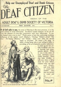
Newsletter, The Deaf Citizen 1931
Newsletter of the Adult Deaf and Dumb Society of VictoriaThe Deaf Citizen Newsletter (Organ of the Adult Deaf and Dumb Society of Victoria) is significant publication as an historical record giving and insight into the people, activities and events of the Deaf Community in Victoria.No. 1, First Quarter 1931; Size 24.5cmHx18.5cmW; 16 pagesaustralian congress of deaf mutes, ernest j. d. abraham, thomas bent, mr rose, education act of 1910, adult deaf and dumb society, e. r. peacock, r. j. oehr, edward newbigin, h. sumner martin, w. h. adeney, j. j. halley, john griffiths, hannah martin, mrs luke, matt miller, j. e. muir, r. j. oehr, l. a. cleveland, norman armstrong, hugh grant rowell, f. g. barnes, g. studdert kennedy, victorian deaf and dumb institution, w. j. mccaskill, john adcock, f. w. g. gilby, lieut. colonel olden -
 Expression Australia
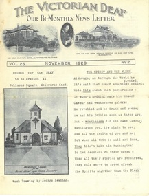
Newsletter, The Victorian Deaf - Nov 1929
Bi-Monthly News Letter - Under the auspices of the Deaf Committee of the Adult Deaf and Dumb Society of Victoria 'The Victorian Deaf' Newsletter is a significant publication as an historical record giving and insight into the people, activities and events of the Deaf Community in Victoria.Vol. 25 No. 2 November 1929; Size 27cmHx21cmW; 15 pagesa. c. muir, william p. muir, w. g. marsh, ymca, john muir, armsstrong, abraham, peacock, simpson hill, hoath, thomas purves, j. stephens, a. course, f. crowther, f. garfield, g. sheahan, h.s. tainton, w. wilcox, alice graham, bessie graham, brooke nicholls, j. m. johnston, deaf women's guild, mrs moss, s. moss, t. peters, frewin, thelma stephens, lacrosse, cricket, lodavia nicholson, elsie stephens, o'callaghan, deaf worker's club, geelong, m. gibson, j. boortz, a. taylor, walter grant, byron taylor, g. edwards, reginald gilbert, mrs cross, mrs hartley, john anderson, w. moloney, a. collins, colin johns, ferguson, damman, j. hunt, c. hunt, winn, j. kenworthy, w. mcmillen, g. henry, l. sanders, m. aram, moss, j. hunt, w. rees, d. driscoll, daphne tyzzer, roy martyr, emily anderson, pat cunningham, patrick o'keefe -
 Expression Australia
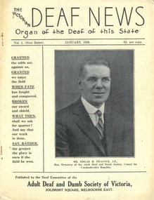
Newsletter, The Victorian Deaf News January 1936
... , muriel smith, ray cornell, w. grant, john mcgonigal, thomas.... smiththelma whateley, thomas newton, roy white, mra and mrs white, h ...Published by the Deaf Committee of the Adult Deaf and Dumb Society of Victoria'The Victorian Deaf News' Newsletter is a significant publication as an historical record giving and insight into the people, activities and events of the Deaf Community in Victoria.Vol. 1 (New Series) January 1936; Size 24.5cmHx18.5cmW; 24 pagesedgar h. peacock, warwick ashby, rev j. h. frewin, theo frewin, fred frewin, freda connolly, iris connolly, lord mayor's queen carnival campaign, mrs abraham, alice graham, victorian deaf and dumb institution, jim johnston, douglas abraham, w. h. crush, henry w. gladwin, j. boortz, dorothy johnston, charlie buck, colin johns, w. mcmillin, h. r. gillet, i. boast, s. nielson, f. sandon, willie hately, joe unsworth, rivers, a. sutherland, m. reiffel, w. durston, j. boal, deaf tennis club, adult deaf cricket club, lacrosse, deaf chess, w. donnelly, willie smith, les sutton, lydia sanders, melby allsop, ruth peters, mortimer, e. r. e. noble, c. graham, l. smiththelma whateley, thomas newton, roy white, mra and mrs white, h. blackmore, e. raines, elsie denman, g. mccaffrey, ethel dow, james frame, muriel smith, ray cornell, w. grant, john mcgonigal, thomas tonkin, john cardwell, william kent, richard hann, annie secombe, winnie henry, g.g. mercy, -
 Expression Australia
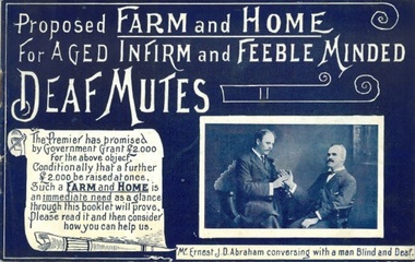
Booklet, Proposed Farm and Home for Aged Infirm and Feeble Minded Deaf Mutes
The Premier of Victoria, the Hon, Thomas Bent, has promised a grant of 2,000 pounds towards providing a Training farm for Feeble-minded, and home for Aged and infirm Deaf Mutes, conditionally that a further sum of 2,000 pounds be raised for the same purpose at once. The Committee of the Adult Deaf and Dumb Mission of Victoria having accepted this generous offer of the Government, produced this booklet with the desire to bring the scheme under the notice of the public with a view of appealing to it for the sum named.This booklet is significant as it marks the beginning of a major project, Lake Farm, Blackburn that sought to provide employment and residential facilities for aged and infirm Deaf adults in Victoria in the early years of the 20th Century.Size 13.5cmHx21.5cmW; 16 pagesdeaf, blackburn, thomas bent,ernest j. d. abraham, south australian farm and home for infirm deaf mutes, -
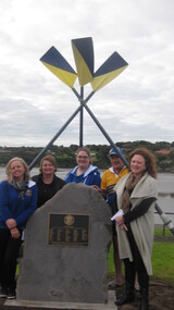 City of Warrnambool Rowing Club
Plaque, 07 08 2016
The City of Warrnambool Rowing Club (CoWRC) received a grant from the Warrnambool City Council Community Development Fund for the project: to hold a public event to install a plaque – dedicated to members and ex members who enlisted in WW1. The original honor roll had been lost to history. The date chosen was August 7 as this was 100 years since the death of a particular member, Major Thomas (Tom) Redford. Process: the Club wrote a book about its 140 year history and learnt of the honor roll. Every effort to find it was exhausted. The Club applied for funds to produce a replacement plaque and have a public event to unveil it. Outcome: There is now a permanent plaque in the rowing ‘prescient’ on the Hopkins River. one meter high stone with brass plaque‘Lest we Forget’ Honour Roll of Warrnambool Rowing Club Members and ex-Members who enlisted for the First World War. Archibald W. Artso E. Baillie T. Battarbee M. Beeching J. Beeching W. Brown J. Brown S. Butler G. Chapman R. Chew A. Collins A. Cordner J.A. Curtis J.P. Davidson W.J.S. Dickson J.R. Dwyer T. Fary G. Fisher C. Fisher R. Flett C. Flett F. Flett V. Foote E. Gartlan L. Granter J. Harris H. Hope W. Humphreys C. Jackway W.R. King C. Lee R. Levy J. London D. MacKinlay W. MacKnight C.C. Manson A. Marfell W.L. McDougall K. McGee W. McKay M. McKay R. McKenzie W. McLennan W. McMeekin W. Mitchell S. Murphy R.S. O'Donnell J. Parsons L. Redford T. Richter F. Roper H. Robinson C.F. Robinson G. Ryan P. Sarll W. Spotswood D. Thompson A. Thompson H.G.(J) Tinker E. Titford R.A. MC Webb W. Williamson C. Every Club member of military age enlisted. A Norfolk Island Pine was planted in November 1916 to perpetuate the memory of former member, Major Thomas Redford, who died at Gallipoli. The tree is believed to be beside the Hopkins River in EJ King Park. Honour Roll rededicated by the City of Warrnambool Rowing Club and Warrnambool City Council, August 7 2016. city of warrnambool rowing club, warrnambool, warrnambool rowing club, hopkins river, hopkins river warrnambool, world war one, first world war, rowing, rowers