Showing 2474 items
matching townships
-
 Stawell Historical Society Inc
Map, Township of Moyston, Parish of Moyston, County of Borung, 1956
Township of Moyston, Parish of Moyston, County of Borungstawell -
Stawell Historical Society Inc
Map, The Township of Elmhurst, Parish of Glenpatrick, Wimmera District
The Township of Elmhurst, Parish of Glenpatrick, Wimmera Districtstawell -
 Melton City Libraries
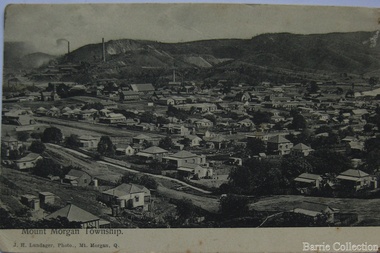
Postcard, Postcard addressed to William Daley, Unknown
A letter sent from Mount Morgan townshiplocal identities -
 Hume City Civic Collection
Photograph, early 1990s
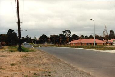
The series of 5 photographs feature different views of the Woodlands Housing Development which opened up land bounded by Gap and Anderson Roads, Cornish Street and Elizabeth Drive in the early 1990s. It was a large housing development built close to Sunbury township.A coloured photograph of one of the last housing developments which took place in the old township area. It is a photograph taken at the north end of Anderson Road looking towards Gap Road. One house has been built and there are a number of 'For Sale' signs of blocks fronting Anderson Road. Guttering and driveways have been formed on one side of the road.housing developments, anderson road, george evans collection -
 Kiewa Valley Historical Society
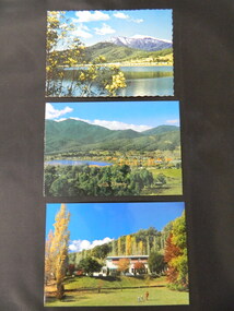
Postcards - Mt Beauty x3
Mt Beauty is an all year tourist destination. Mt Beauty Chalet no longer exists as it was burnt down. It was a landmark in the town especially during the State Electricity Commission of Victoria construction days.Mt Beauty is a construction town built in the 1940's and 1950's by the State Electricity Commission of Victoria during the construction of the Kiewa Hydro Electric Scheme.Three colored postcards created for tourism 1. Mt Beauty Chalet 2. Mt Beauty Township 3. Mt Beauty Township with Pondage and Mt Bogongmt beauty chalet; mt beauty township; postcards -
 Bendigo Historical Society Inc.
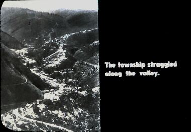
Slide - DIGGERS & MINING. DIGGERS AND MINERS, 1850s
Diggers & Mining. Diggers and Miners. The township struggled along the valley. Photo shows the township along the valley. Markings: 46 994.5 WAL. Used as a teaching aid.hanimounteducation, tertiary, goldfields -
 Orbost & District Historical Society
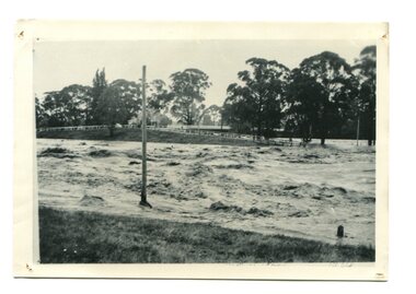
black / white photograph, January 1934
Damage estimated at £500,000 was caused by the 1934 floods in the Orbost district. This 1934 flood was devastating, destroying a section of the 1922 Orbost bridge, wrecking fences, bridges and roads, dumping silt and debris on the rich river flats and drowning cattle. This photograph shows Lochiel Lagoon ( the billabong) in the foreground. Ten minutes after this photograph was taken, the centre span of the Orbost Bridge was washed away.This item is a pictorial record of the 1934 floods, a significant part of Orbost's history.A black / white photograph of swirling floodwaters with township in the background.orbost-floods-1934 natural-disasters-floods -
 Phillip Island and District Historical Society Inc.
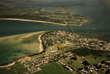
Photograph, Aerial photographs of Phillip Island, 1990s
Coloured photographs showing aerial views of the townships and the Island.rhyll, photographs, cowes, san remo, newhaven, aerial views of phillip island -
 Clunes Museum
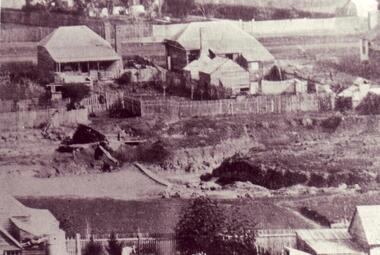
Photograph
BLACK AND WHITE PHOTOGRAPH OF A SMALL SECTION OF CLUNES TOWNSHIPlocal history, photography, photographs, clunes township -
 Clunes Museum
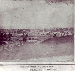
Photograph
CLUNES TOWNSHIP - VIEW OF BUILDINGS, TREES AND HILL IN FOREGROUND.CLUNES FROM ANGUS ST. CIRCA 1879local history, photography, photographs, clunes township -
 Rutherglen Historical Society
Photograph - Image, 1900 Approx
Photograph of the Advance Australia Hotel, Great Northern township.On back of photo: "1st Advance Australia Hotel" | "Hicks/McKay A A Hotel"hotels, advance australia hotel, great northern, hicks, mckay -
 Ballarat Heritage Services
Photograph, Clare Gervasoni, Smeaton From Elizabeth Street, 2009
The Wright family of Clunes lived in Elizabeth Street.Colour photograph of the township of Smeaton from Elizabeth Street.smeaton, elizabeth street, frank wright -
Stawell Historical Society Inc
Map, Township of Crowlands, Parish of Crowlands, County of Kara Kara, 1857
Township of Crowlands, Parish of Crowlands, County of Kara Kara stawell -
Lakes Entrance Historical Society
Book, Maffra and District Historical Society, Maffra Past and Present
A pictorial history of the Maffra Shire and township of Maffra VictoriaM Campbelltownship -
 Whitehorse Historical Society Inc.
document - Map, Melbourne Metro, 1978
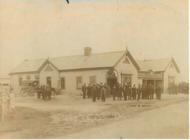
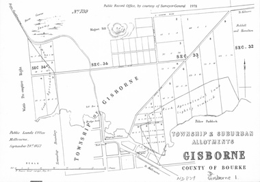
Collection of reproductions issued by the Public Record Office in 1978. Comprises: Allotments in the Black Forest, 1857; Township of Dandenong, 1856; Township and suburban allotments, Gisborne, 1857; Storing Yard allotments near the Melbourne Wharf, 1854; Town lots near the Railway Terminus, Melbourne, 1863; Parish of Prahran, 1853; Township of Sandridge, 1855; Township of Sunbury, 1857; River Yarra Yarra at the Queens Wharf, 1860.victoria. public record office, black forest, victoria, dandenong, gisborne, melbourne wharf, railway terminus, spencer street, melbourne, prahran, sandridge, sunbury, queens wharf -
![Scene near Bright / [by] Nicholas Caire, circa 1876](/media/collectors/550653872162f11fb04854aa/items/578310d1d0cdd1176c462743/item-media/5783113fd0cdd1176c46de2e/item-fit-380x285.jpg) Kew Historical Society Inc
Kew Historical Society IncPhotograph, Anglo-Australasian Photographic Company, Scene near Bright, c. 1876
Nicholas Caire was born on Guernsey in the Channel Islands in 1837. He arrived in Adelaide with his parents in about 1860. In 1867, following photographic journeys in Gippsland, he opened a studio in Adelaide. From 1870 to 1876 he lived and worked in Talbot in Central Victoria. In 1876 he purchased T. F. Chuck's studios in the Royal Arcade Melbourne. In 1885, following the introduction of dry plate photography, he began a series of landscape series, which were commercially successful. As a photographer, he travelled extensively through Victoria, photographing places few of his contemporaries had previously seen. He died in 1918. Reference: Jack Cato, 'Caire, Nicholas John (1837–1918)', Australian Dictionary of Biography.An original, rare photograph from the series 'Views of Victoria: General Series' by the photographer, Nicholas Caire (1837-1918). The series of 60 photographs that comprise the series was issued c. 1876 and reinforced a neo-Romantic view of the Australian landscape to which a growing nationalist movement would respond. Nicholas Caire was active as a photographer in Australia from 1858 until his death in 1918. His vision of the Australian bush and pioneer life had a counterpart in the works of Henry Lawson and other nationalist poets, authors and painters.‘Scene near Bright’ : Views of Victoria (General Series) No.47 : Albumen silver photograph | Photo on card with Title and Description on reverse | Mounted 24 x 30 cm; Photo 12 x 17 cm.On Reverse: ‘The subject of this illustration is taken on the road to Grouber’s, near the township of Bright, in the Beechworth District. The scenery on the rivers and creeks which surround this township is of a very romantic and picturesque description.’nicholas caire (1837-1918), bright (vic), landscape photography - victoria -
 Bacchus Marsh & District Historical Society
Map, Maddingley Township, Parish of Parwan, 1880s
This map is dated Sept. 6th 1856. However places in the township of Maddingley which did not appear until the late 1880s such as the Bacchus Marsh Railway Station and line are shown on this map in their correct locations. This suggests the map has been derived from an earlier map. An earlier date of 1843 with a surveyor's name preceding it can also be seen on the map. The map is important because it indicates the location and dimensions of early but now discontinued use of land such as the showgrounds and police paddock and a site reserved for the Church of England which was not ultimately used for a permanent church. A single page paper map showing land allotments, streets, rivers, creeks, park lands, the railway line and Bacchus Marsh railway station in the township of Maddingley. The map is pasted into a bound volume containing 76 maps or plans in total. Bottom of Map: Surveyor-General's Office, Melbourne, Sept 6th, 1856bacchus marsh victoria maps, maddingley victoria maps, land use, maddingley victoria history -
 Kiewa Valley Historical Society
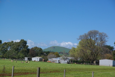
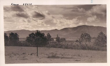
Black and white photograph of farmland, Kiewa, 25/8/38, circa 1938
This photograph was taken in August, 1938 some eight years prior to the establishment of Mt. Beauty as a township. The area was still being used for grazing, and the land was eventually acquired from the local land owners by the State Electricity Commission. The construction of the road, from Tawonga to the High Plains, was commenced in April of this year. This allowed men and heavy equipment to be transported to the work sites for the construction of the Kiewa Hydro Electric Scheme This photograph is important as it shows the upper Kiewa Valley as it was before the establishment of the town of Mt. Beauty. The land has been cleared of natural growth and has been used for grazing cattle. By 1946 housing construction had commenced for the new town of Mt. Beauty and by 1948 street construction in the southern part of the town was completed as far as Hill Street.A black and white photograph of farmland with Mt. Emu in the background. This has been taken from where Mt. Beauty township now stands prior to road making and the erection of houses. A line of trees below the hill line indicates the position of the East Kiewa River. (No. 5 in a set of 8) Handwritten in black ink on the upper left corner of the photograph is the inscription 'Kiewa 25/8/38' and the number 5 has been stamped on the upper right hand corner. On the back is the word 'Velox' which is the name of the photographic paper on which the photo was developed.road construction, kiewa, tawonga, mt. beauty, secv -
![The Township of Walhalla / [by] Nicholas Caire, circa 1876](/media/collectors/550653872162f11fb04854aa/items/57825a89d0cdd1176ce3295a/item-media/57825aefd0cdd1176ce34515/item-fit-380x285.jpg) Kew Historical Society Inc
Kew Historical Society IncPhotograph, Anglo-Australasian Photographic Company, The Township of Walhalla, c. 1876
Nicholas Caire was born on Guernsey in the Channel Islands in 1837. He arrived in Adelaide with his parents in about 1860. In 1867, following photographic journeys in Gippsland, he opened a studio in Adelaide. From 1870 to 1876 he lived and worked in Talbot in Central Victoria. In 1876 he purchased T. F. Chuck's studios in the Royal Arcade Melbourne. In 1885, following the introduction of dry plate photography, he began a series of landscape series, which were commercially successful. As a photographer, he travelled extensively through Victoria, photographing places few of his contemporaries had previously seen. He died in 1918. Reference: Jack Cato, 'Caire, Nicholas John (1837–1918)', Australian Dictionary of Biography.An original, rare photograph from the series 'Views of Victoria: General Series' by the photographer, Nicholas Caire (1837-1918). The series of 60 photographs that comprise the series was issued c. 1876 and reinforced a neo-Romantic view of the Australian landscape to which a growing nationalist movement would respond. Nicholas Caire was active as a photographer in Australia from 1858 until his death in 1918. His vision of the Australian bush and pioneer life had a counterpart in the works of Henry Lawson and other nationalist poets, authors and painters.‘The Township of Walhalla’ : Views of Victoria (General Series) No.37 : Albumen silver photograph | Photo on card with Title and Description on reverse | Mounted 24 x 30 cm; Photo 12 x 17 cm.On Reverse: ‘This romantic Township is situated near Stringer’s Creek in Gipps Land, not far from the celebrated Baw-Baw Mountains. The Long Tunnel Gold Claim has proved a great source of wealth to this small out-of-the-way place, yielding sometimes between 2,000 and 3,000 ounces of gold per month. The population, which is mostly a mining one, reaches nearly 2,000 inhabitants, and are scattered about among the creeks and gullies of the neighbourhood. Until recently, the road traffic was limited to pack-horses, in consequence of the precipitous hills which surround the Town.‘nicholas caire (1837-1918), walhalla, landscape photography -
Warrnambool and District Historical Society Inc.
Document (item) - Allansford land purchase document, Land purchase document, 1864
This paper contains details of the purchase of Lot 11 in the Township of Allansford in 1864. The purchaser, Isabella McQueen, was born in Scotland in 1814, married Alexander McQueen in 1850 and with her family migrated to Australia in 1854. After her husband's death in 1860 Isabella purchased the land in Frank Street, Allansford in 1864 and lived in a house there with family members until her death in 1895. She had purchased the land, via an agent, from John Allan who with his brothers were the pioneer European settlers in the Allansford area. John Allan had created the township of Allansford in the mid 1850s by sub-dividing the land he owned there. John Allan moved to the Gippsland area late in 1864. This piece of paper is most significant as it is an original record of an early transaction in the history of Allansford, a town now part of Warrnambool City.Mrs isabella McQueen Bot. of Robert Gregory As agent for J M Allan Esq. Lot no. 11 as marked and described on the Plan of Subdivision of the Township of Allansford. For which I have received the um of five pounds Stg. being the purchase money of same. Robert Gregory 21st October 1864allansford history, john allan, isabella mcqueen -
 Lakes Entrance Historical Society
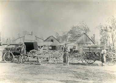
Photograph - Harry Froud's coach factory, P Hancock, 1900 c
Henry Froud's Blacksmith Coach Building and Wheelwright's business set up at original surveyed site west of present township, nearer to cemetery turnoff,. Business first moved to corner of Princes Highway and Bruthen Road, (now site of Black Stump Store), then moved to premises built by Harry Froud on south side of highway, corner of Punt Road, (present site of BP Garage).Black and white photograph of Harry Frouds first coach factory west of present township, showing three men in front of four wheeled vehicles including a steam engine. Three workshops in background, two having bark roofs, man in centre identified as Harry Froud, William Henry. Johnsonville Victoria. transport, factory, people, local history -
 Orbost & District Historical Society
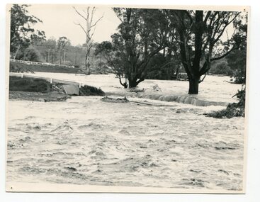
black and white photograph, February, 1971
This photograph shows the floodwaters during the 1971 flood at Orbost. The two mahogany trees in the photograph stopped the Snowy River from changing its course. The 1971 flood was the the worst flood on record. At Jarrahmond it was at least 11 metres and up to one and a half kilometres wide on the flats causing enormous damage to the flood plain. Records say that "The brown floodwater stain in Bass Strait could be seen from passing airliners." Considerable damage was done to railway infrastructure, roads and farms. More information from the APRIL, 2008 newsletter by John Phillips. (see orbosthistory.com.au)This is a pictorial record of a significant event in the history of floods in Orbost.A black / white photograph of raging floodwaters at the bottom of the Orbost township.orbost-flood-1971 -
 Phillip Island and District Historical Society Inc.
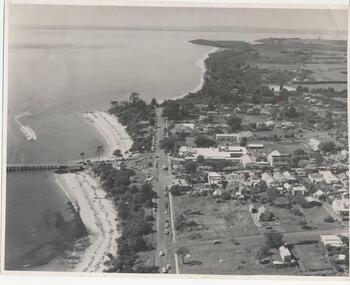
Photograph, Payens' Photographic Services, 1950's
Photograph donated by Jean Bain.Black & White aerial view of Cowes township, foreshore and jetty.aerial view cowes phillip island, cowes phillip island -
 Phillip Island and District Historical Society Inc.
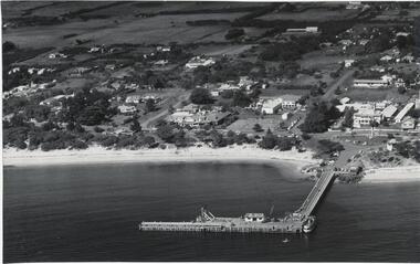
Photograph, Bryant West
One of a collection of over 400 photographs in an album commenced in 1960 and presented to the Phillip Island & Westernport Historical Society by the Shire of Phillip Islandaerial photograph, part of Cowes Township and beach with Jetty in foregroundlocal history, photography, photographs, part cowes township - cowes beach and jetty, cowes township, beach, jetty, john jenner, bryant west -
 Myrtleford and District Historical Society
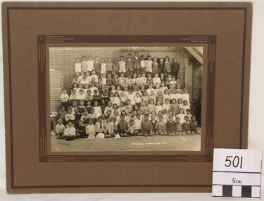
School Photograph, J. Check, Myrtleford State School 955, 1922, Circa 1922
This whole of school photograph depicts the school pupil population in the "prosperous twenties". The pupils have been congregated against the external wall on the SE side of the school outside the Head Master's office and pupil's cloakroom. This is one of several photographs taken in 1922; others feature composite groups of classes. The photograph records the post-war school population at its peak in 1922. The following year,St. Mary's Convent School would commence and numbers at Myrtleford State School 955 would decline for the rest of the decade. The coverage of the whole school population provides a snapshot of all families attending the school.A monochrome photograph of the whole pupil enrolment at the Myrtleford township schoolSchool and Photographer name inscribed: "State School Myrtleford, 1922" "J. Check"myrtleford state school 955 -
 Buninyong & District Historical Society
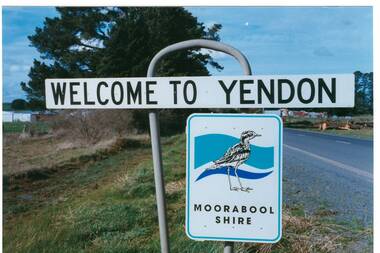
Photograph - Original Photograph, Mr. C.J. Brooks, Yendon township sign, September 1995
Social, historicalYendon township sign taken in September 1995 showing the Moorabool Shire signage of that timeColour photo, Welcome to Yendon Sign on the Western outskirts of the townshiproad signs, yendon, moorabool shire, streetscape -
 Uniting Church Archives - Synod of Victoria
Photograph, 1868
B & W reproduction of original photograph of the township of Vaughan in 1868vaughan -
 Clunes Museum
Photograph
BLACK AND WHITE PHOTOGRAPH OF CLUNES TOWNSHIP, TAKEN FROM "THE ROCKS"VIEW FROM "THE ROCKS" CLUNESlocal history, photography, photographs, clunes township -
 Clunes Museum
Photograph
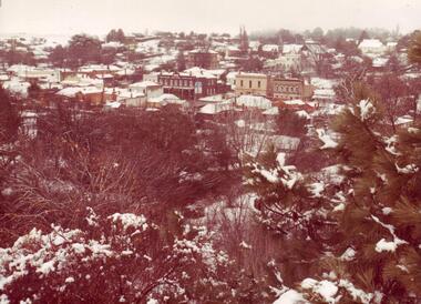
SEPIA PHOTOGRAPH - CLUNES TOWNSHIP AFTER SNOW STORM 1981.local history, photography, photographs, township -
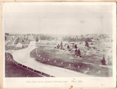 Clunes Museum
Photograph, CIRCA 1879
PHOTOGRAPH OF CLUNES TOWNSHIP, SHOWING THE TWO BRIDGES ACROSS THE CREEK.VIEW FROM ABOVE PRESENT VICTORIA PARK.local history, photography, photographs, bridges - buildings and landscape of clunes