Showing 251 items
matching tribe
-
 Federation University Art Collection
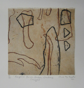
Printmaking - etching, 'Kangaroo Bones, Broken Crockery, Drought' by Anne McMaster, 2008
Anne McMaster (1959- ) Born Melbourne Artists' Statement: In the thick of drought kangaroos perish and farmers walk off the land. All that is left are bones and broken crockery. Overlaid images prompt the observer to question the Anglo-Saxon relationship to country, to that of indigenous tribes. Foul biting and earthy colours bring attention to the weathered landscape of Australia. This item is part of the Federation University Art Collection. The Art Collection features over 2000 works and was listed as a 'Ballarat Treasure' in 2007.Framed limited edition print.art, artwork, anne mcmaster, print council of australia, kangaroo, bones -
 National Vietnam Veterans Museum (NVVM)
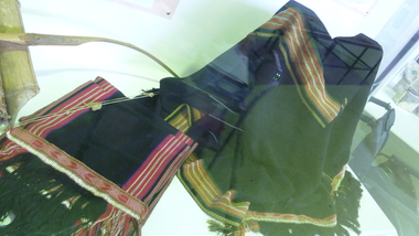
Clothing - Montagnard traditional costume
Montagnard people were the indigenous non-Vietnamese ethnic minorities living in the Central Highlands of Vietnam. Australian Army Captain Barry Petersen was sent to Vietnam in 1963 as part of the elite Australian Army Training Team to train Montagnard rebels in how to deal with the guerrilla tactics used by Viet Cong insurgents. The laplap is an integral part of the traditional ceremonial costume of various Montagnard groups, particularly the Rhade tribe, with whom Petersen lived and worked, learning their language and wearing their traditional clothing.Top and shawl black. Embroidery and weaving in white, red and ocremontagnard, ceremonial costume, laplap, loincloth, petersen, barry petersen, rhade, rade -
 National Vietnam Veterans Museum (NVVM)
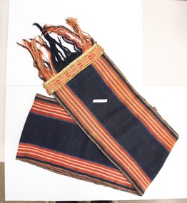
Clothing - Laplap
This item was given to Captain John E D White, of the AATTV, by the Chief of the Rhade/Rade tribe, whose wife had woven it. The chief was John's recruitment officer in 1968. During the Vietnam War, the Rhade would be "recruited" from their villages to work with various units such as the MIKE force led by Captain White. As well as fighting-power, they were valuable for their understanding of the local environment. Like all Montagnards serving in the war, translation was also a vitally important skill they provided.Long piece of coarsely woven fabric with patterned braid and fringing at each end. Fabric is striped vertically with broad black sections and fine lines of yellow, white, and red.montagnard, white, rhade tribe, vietnam, john white, jed white, lap lap, laplap, loin cloth, rade -
 City of Moorabbin Historical Society (Operating the Box Cottage Museum)
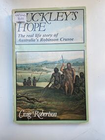
Book, Globe Press Pty. Ltd, Buckley's hope : the story of Australia's wild white man, 1981
A small soft cover book with a blue/green cover,on the front cover is a painting of early Australia with Indigenous Australians hunting with spears alongside them is a European with long unkept hair and a beard dressed in animal skins,on the back cover is text by the author giving a brief outline of the book.buckley, sorrento, robinson crusoe, port phillip, van diemen's land, colonialism, 1840, convicts, indigenous tribes. -
 City of Moorabbin Historical Society (Operating the Box Cottage Museum)
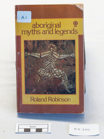
Book - Aboriginal stories, Sun Books Melbourne Pty Ltd, aboriginal myths and legends, 1967
A collection of stories of Aboriginal mythsxvi, 218 p. illus. : non-fictionA collection of stories of Aboriginal mythsaboriginal, human rights, myths, legends, robinson roland edward, australian indigenous tribes, storytellers, poetry, roper river, northern territory, sydney morning herald, the age, folk-lore, dreamtime legends, sacred songs, vesper alexander, worrell eric, naturalist, zoology, legend and dreaming -
 Bendigo Historical Society Inc.
Document - Recent Discovery of Human Remains near Goornong
In reprisal for the deaths of five aboriginals of the Taurigurung tribe, aboriginals killed James Neill, hutkeeper and Hugh Bryan, shepherd on 22/5/1832. These men worked on an outstation of Campaspe Plains sheep run owned by Capt. Charles Hutton. The outstation was at Wild Duck Creek. At the same time the aboriginals stole 700 sheep. In response, Hutton led a party that killed 40 aboriginals and found most of the sheep. Another raid with mounted police killed another six. Campaspe Plains was sold in the early 1840's and was broken up into smaller pastoral leases.A collection of three local Police papers detailing the discovery of the human remains of the early settlers James Neill the Hutkeeper and the Shepard Hugh Bryan and the detailed report of their passing caused by local Aboriginals who were threatened by recent expansion.hugh bryan, james neill, police -
 Eltham District Historical Society Inc
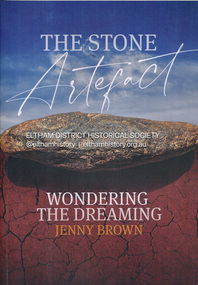
Book, Jenny Brown, The stone artefact : wondering the dreaming, 2022
The discovery in a Melbourne park (opposite the Osborne Peninsula, North Warrandyte) of an enigmatic Aboriginal stone tool led writer Jenny Brown on a fascinating journey that connected her with expert anthropologists, archeologists, Indigenous elders and knowledge holders to discover what it was. The stone tool invited many interpretations and spun off just as many amazing stories and experiences. It also afforded Jenny the appropriate canvas to tell of her own time-warping encounters with the extraordinary "otherness" of Aboriginal Australia, and with an especially marvelous character, the late Elder of the Yuin Tribe of southern NSW, Guboo Ted Thomas.193 pages : illustrations (chiefly colour), maps, portraits ; 30 cmindigenous history, aboriginal artefacts, warrandyte, archaeology -
 Peterborough History Group
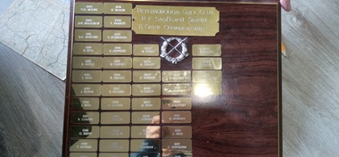
Plaque - P. F. Stafford Shield
Annual B Grade trophy for the Club Championship. Percy .F Stafford owned a jewellery shop in Warrnambool, he purchased the Chirnsides house and became a committed member of the club. Winners are: 1979 C. O. Moore, 1980 D. H. Bradshaw, 1981 D. A. McKenzie, 1982 B. King, 1983 R. Paton, 1984 L. King, 1985 J. McNab, 1986 J. King, 1987 R. Loader, 1988 G. Smith, 1989 P. Bourke, 1990 D. Cooke, 1991 P. Sloane, 1992 T. Barrett, 1993 S. Robilliard, 1994 P. Deppeler, 1995 B. Couch, 1996 H. Nelson, 1997 R. Loader, 1998 R. Loader, 1999 J. Wallis, 2000 F. Carlin, 2001 L. Deppeler, 2002 K. Cleary, 2003 M. Fisher, 2004 K. Cleary, 2005 D. Laherty, 2006 F. Carlin, 2007 M. Tribe, 2008 J. Leishman, 2009 D. Drake, 2010 J. Leishman, 2011 D. Laherty, 2012 T. Calvert, 2013 M. Bowden, 2014 T. Calvert, 2015 M. Bowden, 2016 L. Beer, 2017 C. Huffadine, 2018 J. Watene, 2019 J. Costin, 2020 Covid, 2021 C. Huffadine, 2022 N. TribeSignificant because it records the annual winner of the B Grade golf club championship.Rectangular wooden Honour Board with engraved individual plaques listing the individual winners name and date. It feature a raised silver wreath with crossed golf clubs. Peterborough Golf Club P.F. Stafford Shield B Grade Championshipp. f. stafford, peterborough, golf, peterborough golf club, sporting honour boards, b grade golf -
 Victorian Aboriginal Corporation for Languages
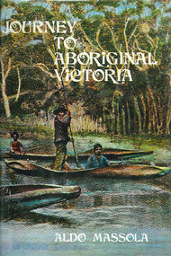
Book, Aldo Massola, Journey to Aboriginal Victoria, 1969
Looks at the Aboriginal community from the time of white contact, across many parts of Victoria. Chap.1; Melbourne - early missions, camp of Native Police, corroboree trees, canoe trees, grave &? headstone of Derrimut; quarries at Keilor, excavation sites at Green Gully &? Keilor; quarry at Mt. William, notes on inheritance of quarries Coranderrk settlement - Barraks grave, notes on his life; Chap.2; Geelong - Yawangi group of the Wothowurong tribe, camping grounds in area quarries; Notes on William Buckley, Gellibrand (a notable Aboriginal), graves in the Western Cemetery; Chap.3; Colac - war between Colac &? Geelong tribes; Mission at Birregurra, reason for failure of Buntingdale Mission; brass plate to Coc-coc-coine; reserve at Elliminyt, native ovens, camp sites, initiation site &? ritual; quarry sites, axegrinding factory, rock pecking &? engraving; dried hand &? 3 Aboriginal skulls found; Chap.4; The south-west coast - middens, camp sites notes on Framlingham Stn., fish traps at Tyrendarra; Chap.5; The far west - massacres of Aborigines near Casterton; camp sites, oven mounds; the first cricket team formed; Aboriginal cemetery; Chap.6; Hamilton - camps; Mount Rouse Station, axegrinding grooves at Nareeb Nareeb, shelters described, fish traps, massacre at Lake Condah; mission; canoes; Chap.7; Camperdown - legend about Lake Bullen Merri; obelisk erected in memory of Aborigines of district especially chief Wombeetch Puyuun; Jarcoort tribe; fish weirs, camps, intertribal fights between Booluc-burrers, Jarcoorts &? Ellengermote groups; bartering place at Mount Noorat; articles traded, legend of Flat-Top Hill; Chap.8; Ballarat - camp at Lake Wendouree; White Stone Lagoon; legends concerning Mt. Buninyong &? waterfalls at Lal-lal; camp sites; pygmy-type implements near Meredith, quarry at Glue Pot Rocks near Durdidwarrah; brass plate of King Billy; Chap.9; Ararat - Tjapwurong territory; camp sites, quarries, shield &? canoe trees; Bunyip belief at Lake Buninjon of Muk-jarawaint &? Pirtkopen-noot tribes, gives legend; stone implements; mill stones; fish weirs; stone arrangement near Lake Wongan; ground drawing of a bunyip, paintings in rock shelter near Mt. Langi Ghiran; Chap.10; Maryborough - camps, oven mounds, rock wells, stone arrangement at Carisbrook; camp sites at Mt. Franklin; Chap.11; Charlton - belief in Mindye (snake); canoe trees, ovens, camp sites, water holes, rock wells, stone implements; method of rainmaking; Chap.12; Horsham-Stawell, The Wimmera - Wotjobaluk land; camps, fish traps at Toolondo; Black Range cave paintings, Flat Rock shelters (detailed account of these paintings); Bunjils Cave; Chap.13; Horsham-Stawell, The Mallee - camp sites, implements; Ebenezer Mission, Willie Wimmera taken to England by Rev. Chase to become a missionary, died in England; Chap.14; The Murray River, Mildura Swan Hill - Battle of the Rufus; ceremonial ground, Lake Gol Gol, canoe &? shield trees; stone implements; camp sites, fire place arrangements; fish traps; oven mounds; Chap.15; The Murray River, Swan Hill-Echuca - legend about Lake Boga; camps, oven mounds, the Cohuna skull, Kow Swamp, method of burial; Chap.16; Shepparton ovens; brass plates of King Paddy of Kotupna &? King Tattambo of Mulka Stn., native well, camps; Chap.17; Wangaratta -camps, quarry, rock holes, the Faithful massacre; grinding rocks at Earlston; Chap.18; The High Plains - Ya-itma-thang; camps, Bogong moth feasts, native paths for trade &? intertribal fights, articles traded; painted shelters; Koetong Ck. Valley, near Mt. Pilot &? near Barwidgee Ck.; Chap.19; Dandenong - water holes, list of 8 holes in Beaumaris - Black Rock area; camps, middens, stone implements (microliths), legend of Angels Cave, stone axes, Native Police Force, Narre Narre Warren Station, legend about rocks on Bald Hill, kangaroo totemic site; Chap.20; Wonthaggi- Yarram - natives visit Phillip Is., murder of William Cook and Yankee by five Tasmanians (listed as Bon Small Boy, Jack Napoleon Timninaparewa, Fanny Waterpoordeyer, Matilda Nattopolenimma and Truganini) near Cape Patterson, men; camp sites, middens, legend of White Rock; Chap.21; Sale - Bairnsdale, The Lakes Country middens, camps; legend at Wulrunjeri; story of a white woman supposedly living with with the Tutangolung tribe, efforts made to prove story; canoe trees; Chap.22; Sale-Bairnsdale, The Inland Braiakolung tribe, camps, implements, canoe &? shield trees; Ramahyuck Mission, grinding rocks, fights with Omeo tribe; native tracks, death through enemy magic - procedure, belief in ghosts; Chap.23; Lakes Entrance and the Country to the east - Kroatungolung people, legend of Kalimna Valley; camps, stones of Nargun, bunyip, devils at Lake Tyers, excavation at Buchan, carbon dates; middens, ochre at Cape Conrad, stone fish-hook file at Thurra River; note on Bidwel tribe; Each chapter gives historical details, early contacts, relationships with settlers; Aboriginal place names and detailed description of sites and geographical features.b&w photographs, b&w illustrations, colour illustrationsgeelong, colac, hamilton, camperdown, ballarat, ararat, maryborough, charlton, horsham, stawell, murray river, shepparton, wangaratta, dandenong, wonthaggi, yarram, sale, bairnsdale, lakes entrance -
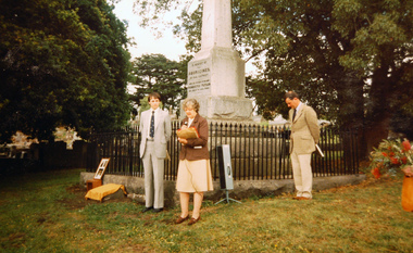
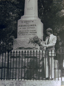
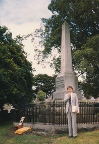 Camperdown & District Historical Society
Photograph - Unveiling plaque at the Wombeetch Puyuun Monument in the Camperdown Cemetery, 12/12/1983
When he died in February 1883, Wombeetch Puyuun was the last member of the Liwura Gundidj clan still living on Country at Camperdown. The Wombeetch Puyuun Monument was erected by his friend and Guardian, James Dawson in 1885, largely at his own expense. At the top is engraved 1840, which marked the beginning of the demise of the local First Nations people. Below are a boomerang, a club, and a message stick. At the bottom is the year 1883 which saw the last of the local First Nations people on Country with the death of Wombeetch Puyuun. On the base are the words: "In memory of the Aborigines of this district. Here lies the body of the chief, Wombeetch Puyuun, and the last of the local tribes". Dr Ken Coghill (Minister for Aboriginal Affairs) unveiling plaque in front of the Wombeetch Puyuun Monument in the Camperdown CemeteryBack: Dr Ken Coghill unveiling the plaque in front of the Aboriginal Monument in the Camperdown Cemetery Dec 12th 1983cdhs, djargurd wurrung, djargurdwurrung, cdhsfirstnations, first nations people -
 Camperdown & District Historical Society
Photograph - Unveiling plaque at the Wombeetch Puyuun Monument in the Camperdown Cemetery, 12/12/1983
When he died in February 1883, Wombeetch Puyuun was the last member of the Liwura Gundidj clan still living on Country at Camperdown. The Wombeetch Puyuun Monument was erected by his friend and Guardian, James Dawson in 1885, largely at his own expense. At the top is engraved 1840, which marked the beginning of the demise of the local First Nations people. Below are a boomerang, a club, and a message stick. At the bottom is the year 1883 which saw the last of the local First Nations people on Country with the death of Wombeetch Puyuun. On the base are the words: "In memory of the Aborigines of this district. Here lies the body of the chief, Wombeetch Puyuun, and the last of the local tribes".Dr Ken Coghill (Minister for Aboriginal Affairs) unveiling plaque in front of the Wombeetch Puyuun Monument in the Camperdown CemeteryBack: Dr Ken Coghill unveiling the plaque in front of the Aboriginal Monument in the Camperdown Cemetery Dec 12th 1983cdhs, djargurd wurrung, djargurdwurrung, cdhsfirstnations, first nations people -
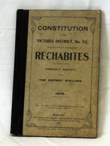 Orbost & District Historical Society
book, Constitution of Rechabites, 1906
This item belonged to Alan Richardson, a sawmiller at Tabbara. He helped to build and held a ticket for the paddle steamer "Curlip". He was a member of the Rechabites from March 3 1892. The Independent Order of Rechabites began in Salford, England in 1835. It was named after Rechab, a leader in the Old Testament, who instructed his tribe to refrain from drinking alcohol. During the Industrial Revolution the idea of temperance became popular as damage was caused to families by alcohol. In Australia it was first established in Tasmania in the mid 1800s. In 1847 a branch was created in Victoria, and it then spread to other States. Members were provided with assistance during times of sickness, death and hardship. This item is associated with the Richardson family, early settlers in the Orbost district.A small grey book with a black spine. The title and details are in black print. Inside is a magazine cutting - "The Rechabite July 1st 1931". This book is the "Constitution of the Victorian District, No 82" and contains the district by-laws."This is to certify that Bro. A.J. Richardson was admitted clearance a member of the Orbost.........."richardson-alan rechabites -
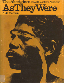 Victorian Aboriginal Corporation for Languages
Book, Aldo Massola, The Aborigines of south-eastern Australia : as they were, 1971
Contents: p.1-3; Origins, arrival in Australia; p.4-9; How they lived - camp sites, dating (including carbon dating); p.10-27; Physical appearance, skin colour, hair, clothing, body ornaments, cicatrization; exchange system, distribution of food, marriage &? sexual relations; the tribe - structure, relationship to land, territory, gives map showing locations of tribes, New South Wales, Victoria &? eastern South Australia, leadership, government, division of labour, status of women, estimated population at white settlement, density of population (Victoria); p.28-31; Language - names &? naming, reproduces Wembawemba vocabulary, notes use of secret languages, gives 12 rules for pronounciation; p.32-53; Religion, spirit beliefs, totemism, moieties, phratries, marriage rules; mythology, gives eaglehawk &? crow myth from Lake Victoria &? other myths illustrating origins of fire &? natural rock formations, mythical beasts (Bunyip, Mindie), stellar beliefs; magic, medicine men, powers, native remedies for sickness, describes ceremony held in Melbourne, 1847 to avert evil, sorcery, pointing bone, love magic, rain makers; messengers, appearance, etiquette, message sticks; p.54-71; Rock art, motifs, colours, decorative art, engraving of utensils, rock engravings, manufacture &? use of pigments, engraving techniques; trade system, objects bartered, meeting places for trade (Victoria), map shows possible routes (south east Australia); corroborees, purpose, body ornaments &? decorations, musical instruments; p.72-93; Ceremonial life, marriage, punishment for infidelity, birth, childhood, games &? amusements, initiation, etiquette of visiting tribes, details of ceremony, womens role, earth figures &? ground designs, bull roarers, female puberty ceremonies; p.94-133; Shelters, fire making, cooking, construction of canoes, wooden implements, use of reeds, animal skins &? sinews, shells; stone tools, cylindro conical stones, scrapers, knives &? microliths; hunting weapons, spear, other methods pits, nets; fishing methods &? spears, traps; food sharing, womens responsibilities for collecting, digging stick, cooking methods, insect foods, plant foods, water resources; manufacture &? use of spears, spear throwers, shields, clubs, boomerangs; inter- &? intratribal fighting; p.134-147; Death, disposal of body - eating of the dead, burial, cremation, platform exposure, dendroglyphs (N.S.W.), Aboriginal burial grounds (Darling &? Murray Rivers), mourning, widowhood, kopi caps (N.S.W.), causes of death, inquest ceremonies, revenge expedition, after death beliefs; p.148-157; The end of the tribes white settlement &? its impact on Aboriginal life, friction between natives &? settlers, establishment of Protectorates; copiously illustrated throughout.maps, b&w illustrations, b&w photographswemba wemba, murray river, darling river, lake victoria -
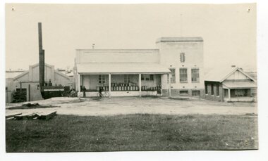 Orbost & District Historical Society
black and white photograph, 1917
This photograph shows the Orbost Butter factory, which in 1917, installed a very successful electric light. the dark heap to the left of the road is Supposedly the grave of "Dan the Cook" who was speared by Aborigines in 1857. Dan Moylan, known as "Dan the Cook"was speared to death in 1851 at Orbost Station, Snowy River as punishment for kidnapping a young Aboriginal girl and holding her for three days, refusing to release her. The men of the tribe congregated at Dan's hut. When Dan came outside, a volley of spears was launched at him, killing him. In the tragic aftermath, the camp at Milly Creek was attacked in retribution and a number of Gunai/Kurnai people were killed. The Orbost Butter and Produce Co. Ltd was registered on June 1st 1893 and was an important source of income to the Orbost district. These photos are pictorial records of the Orbsot Butter Factory.A black / white photograph showing a large white building and factory beside it. on the verandah are about thirty milk churns. There are three men standing astride bicycles in front of the verandah. On the left hand side is a mound of dark soil?? -
Albert Park-South Melbourne Rowing Club
Photograph, 1914 South Melbourne Rowing Club Photo, 1914
This photograph was taken after the first members of the South Melbourne Rowing Club enlisted in World War One. It was originally published in 'Punch' on 3 December, 1914 on page 19. The names of the men are as follows: Top Row.—Messrs. E. Staff, W. McCabe, C. Wolff, N. Jackson, W. Giles, V. Whelan, G. Tully (Hon. Treasurer), S. Thompson, H. Jones, T. Moves, J. Sherman. Second Row.—Messrs. G. A. Firman, C. Clarke, C. C. King, D. A. Bowman, A. Payne, W. Theil, V. Harcourt, B. Tribe, G. McKay, L. F. Bligh, W. Curtis, B. Haines. Third Row.—Messrs. F. Tobitt, J. J. Scanlan, P. Lohan, A. Jamieson, F. J. G. Maher, J. Bernet, H. Tribe, R. Cazaly, A. Henry, J. Meens, F. Mardell, T. Barrell, C. Bond, A. Casey. Sitting.—Messrs. C. De Fraga, A. Crook (Asst. Hon. Secretary), C. Borrman, R. C. Curwen, P. C. Shaw, W. McKay (Vice-President), A. H. Warland (President), G. T. Hastie (Vice-President), G. Anderson (Captain), H. C. Kennett, Fred L. Loud (Hon. Secretary), H. Dixon, G. Barrell (Vice-Captain). Front.—Coxswains D. Fereday, N. Tobitt, J. Maddock, N. Campbell, D. Donaldson.A black and white photograph depicting five rows of men, standing and seated in uniforms and suits. The photograph is under glass with a brown wooden frame.On reverse: N. Giles top row, 4th from left. -
Victorian Aboriginal Corporation for Languages
Book, Robert Brough Smyth, The Aborigines of Victoria : with notes relating to the habits of the natives of other parts of Australia and Tasmania : compiled from various sources for the Government of Victoria by R. Brough Smyth : vol. 1, 1878
Produced in two large volumes, Robert Brough Smyth has collected information on various tribes and their customs, as well as their physical and mental character; birth and education of children; marriage; death and burial of the dead; daily lives of the natives; food; diseases; dress and personal ornaments; weapons; implements and manufacturers; nets and fish hooks; methods of producing fire; canoes and myths. Smyth also devotes about two hundred pages to Aboriginal languages, as well as including details and customs of the aborigines in Tasmania. Complete with hundreds of sketches, the work is still a valuable resource not only for those with in an interest in aboriginal culture, but also those wanting to know the early history of Australia.maps, b&w illustrations, word listsrobert brough smyth, anthropology, aboriginal social life and customs, children, behaviour, death and burial customs, daily life, food, diseases, weapons, shields, boomerang, vessels, baskets, message sticks, stone tool technology, fire, canoes, myths, stories -
Victorian Aboriginal Corporation for Languages
Book, Robert Brough Smyth, The Aborigines of Victoria : with notes relating to the habits of the natives of other parts of Australia and Tasmania : compiled from various sources for the Government of Victoria by R. Brough Smyth : vol. 2, 1878
Produced in two large volumes, Robert Brough Smyth has collected information on various tribes and their customs, as well as their physical and mental character; birth and education of children; marriage; death and burial of the dead; daily lives of the natives; food; diseases; dress and personal ornaments; weapons; implements and manufacturers; nets and fish hooks; methods of producing fire; canoes and myths. Smyth also devotes about two hundred pages to Aboriginal languages, as well as including details and customs of the aborigines in Tasmania. Complete with hundreds of sketches, the work is still a valuable resource not only for those with in an interest in aboriginal culture, but also those wanting to know the early history of Australia.b&w illustrations, word listsrobert brough smyth, philip chauncy, william ridley, albert le souef, a. w. howitt, john moore davis, william locke, a. f. a. greeves, language comparisons, phrenology, aboriginal social life and customs, death and burial customs, weapons, tasmania, lake tyers, lake wellington, gippsland, ballarat, brabrolong, lake hindmarsh, kotoopna -
 Orbost & District Historical Society
book, 1931
This diary probably belonged to Alan Richardson who was a member of the Rechabites. Alan Richardson, was a wmiller at Tabbara. He helped to build and held a ticket for the paddle steamer "Curlip". He was a member of the Rechabites from March 3 1892. The Independent Order of Rechabites began in Salford, England in 1835. It was named after Rechab, a leader in the Old Testament, who instructed his tribe to refrain from drinking alcohol. During the Industrial Revolution the idea of temperance became popular as damage was caused to families by alcohol. In Australia it was first established in Tasmania in the mid 1800s. In 1847 a branch was created in Victoria, and it then spread to other States. Members were provided with assistance during times of sickness, death and hardship. This item is associated with Alan Richardson. The Richardsons were a prominent pioneering family in early Orbost.A small book, a diary with a fabric and paper cover. It contains handwritten costings for building projects, There are some loose pages with Literature associated with the Rechabites. rechabites richardson-alan -
 Eltham District Historical Society Inc
Photograph, Fay Bridge, Eastern boundary of former Warrandyte Aboriginal Reserve, North Warrandyte, 7 November 2016
Two bronze commemorative plaques on rocks, unveiled by Wurundjeri Tribe Council Elders, mark two eastern boundaries of the former Warrandyte Aboriginal Reserve on the north and south sides of the Yarra. This project was initiated by Nillumbik Reconciliation Group in close association with Reconciliation Manningham and the Wurundjeri Tribe Council, as a means of commemorating the last great corroboree of the Kulin Nation which was held at Pound Bend in March 1852. This plaque is on the Nillumbuk side of the Yarra, accessed via The Boulevard, North Warrandyte. The plaque is set on a rock approximately 50 metres before the turning circle at the end of The Boulevard. Plaque : Warrandyte Aboriginal Reserve This commemorative rock marks an eastern boundary of the former Warrandyte Aboriginal Reserve established in 1852. Centred on Pound Bend, it covered 1,908 acres on both sides of the Yarra River (Birrarung). That same year saw the last great gathering of the Kulin nation here in Wurundjeri country which was celebrated over two weeks with traditional performance and games. For a few years longer the reserve intermittently served as a ration station.With gold having been discovered at Warrandyte, the Wurundjeri were moved on again but ultimately secured a permanent home at Coranderrk, Healesville. A second commemorative plaque and rock is located on the opposite bank of the Yarra and its confluence with Stony Creek. Melway ref : 23 C 9 Unveiled by Wurundjeri Elder, Uncle Bill Nicholson on 23rd March 2013 Funded by the Robert Bridgford Indigenous Trust (Nillumbik Community Fund) with assistance from Manningham City Council Small Grants Program Ref: Monument Autralia https://monumentaustralia.org.au/themes/culture/indigenous/display/99680-warrandyte-aboriginal-reserve-fay bridge collection, 2016-11-07, aboriginal reserve, north warrandyte, plaques, warrandyte aboriginal reserve -
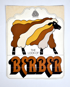 National Wool Museum
Card - Packaging – The Look of Berber, c.1980s
Modern industrialized Berber carpets are distinguished by a loop pile construction type that gives a similar appearance to the distinct knot of traditionally woven Berber carpets. The modern carpets usually contain small flecks of dark colour on lighter shades of background colours resembling a natural undyed version of the traditional carpets. Berber is known for being one of the oldest and most durable kinds of carpet. Traditionally, Berber carpets are carpets hand-woven by the Berber people in North Africa and the Sahara. The carpets come in traditional and modern designs, which are distinguished by different knotting patterns, dyes and fabric textures. The origin of carpet weaving by the Berber populations dates back several millennia. The hand-spun cloth they created was named after the individual tribe, and they used natural fibres to create cloaks, rugs and other fabrics. Card showing printed text and graphic featuring an image of a sheep in tones of orange, brown and cream. Printed: PURE NEW WOOL / THE / LOOK OF / BERBERcollins bros mill pty ltd, manufacturing, geelong, wool, berber -
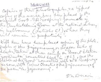 Bendigo Historical Society Inc.
Ephemera - HARRY BIGGS COLLECTION: ENVELOPE
Cream coloured envelope with cello tape on the back with some rust marks.. On the front hand written in blue ink by S. M. Deravin writes about the photo's in the envelope. It is entitled 'Aboriginies' Copies of these photographs and a typed copy of the verses have been placed in the original book - F. R. Godfrey's journals in the Australiana Room at the National Library in Melbourne (Latrobe St) where they will remain 'in perpetuity'. With them have been placed copies of the photographs of the Jajoweroung or Loddon tribe of blacks, taken at their camp on 'Boort Station' (now 'Dunbar' homestead block) in 1963 and the stables at the 'Boort' homestead with M. H. Godfrey and his sons, with Prince Charlie of the Jajoweroung and of the poem 'The Jajoweroung' These photos and descriptions are in 2400.419a and 419b, also 2400 420a and 420b.S. M. Deravinphilately, postal stationary, aborigines, f. r. godfrey, 'dunbar', 'boort homestead' jajoweroung, s.m. deravin. -
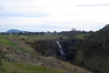 Victorian Interpretive Projects Inc.
Photograph - Photograph - Colour, Clare Gervasoni, Lal Lal Falls, Victoria, 2014, 09/2014
Lal Lal Falls Reserve contains one of the most spectacular waterfalls in the Moorabool Shite. The watefall is part of the on Lal Lal Creek, a tributary of the Moorabool River. and plunges 30 metres from a high basalt column into a deep ravine. Culturally, the Falls are believed to be the earthly home of Bunjil, the All Father or Creator to most Victorian Aboriginal tribes. The name Lal Lal is thought to be Aboriginal for "dashing of waters". The Lal Lal Falls is listed on the Site Registry of Aboriginal Affairs Victoria as a spiritual place. in 1837 a Government Survey Party led by Frederick D'Arcy documented these Falls on the west branch of the Moorabool River. On the reserve opposite, a Race Meeting was held on every New Years Day from 1860 until 1938, attracting crowds of up to 20,000 people. A branch Railway Line was constructed from the Lal Lal station to the Racecourse to convey the crowds.Colour photographs of Lal Lal Falls near Ballarat, Victoria.lal lal falls, waterfall, lal lal, bunjil -
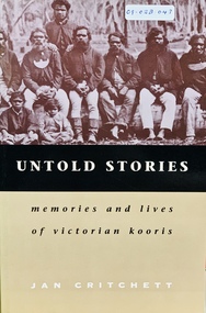 Port Fairy Historical Society Museum and Archives
Book, Melbourne University Press, Untold stories : memories and lives of Victorian Kooris, 1998
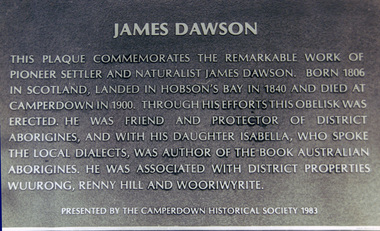
'I'm your half-brother and I'm here to stay. This is my home.' With these words Wilmot Abraham sought refuge with his white relations. 'Did you ever read your history?': Mrs. Mary Clarke remembers p. 1 'An old hand': Jim Cain p. 12 'I'm your half-brother, and I'm here to stay': Wilmot Abraham p. 36 The Three Pompeys The Written Record p. 48 Banjo Clarke's Stories p. 62 'Why did they take them away?': Lizzie and Henry McCrae p. 74 In Defence of Framlingham: Collin Hood p. 79 Double Dispossession: King David p. 107 James Dawson's Informants p. 137 'Why are we kept prisoners here?': Ernest and Maggie Mobourne p. 148 'The old ones, they wouldn't tell us nothing': Mrs. Connie Hart's memories p. 181 'Breaking the cycle is the hard thing to do': Geoff Rose, a stolen child p. 200 Epilogue: James Dawson, Camperdown George and the Obelisk p. 220 The Hood Family p. 238 The Mobourne Letters p. 241 Abbreviations p. 252 Notes p. 252 Bibliography p. 264 Index p. 274xxi, 283 p. : ill., facsims., map, ports. ; 23 cm. Includes index and bibliographical references: p. 264-273.non-fiction'I'm your half-brother and I'm here to stay. This is my home.' With these words Wilmot Abraham sought refuge with his white relations. 'Did you ever read your history?': Mrs. Mary Clarke remembers p. 1 'An old hand': Jim Cain p. 12 'I'm your half-brother, and I'm here to stay': Wilmot Abraham p. 36 The Three Pompeys The Written Record p. 48 Banjo Clarke's Stories p. 62 'Why did they take them away?': Lizzie and Henry McCrae p. 74 In Defence of Framlingham: Collin Hood p. 79 Double Dispossession: King David p. 107 James Dawson's Informants p. 137 'Why are we kept prisoners here?': Ernest and Maggie Mobourne p. 148 'The old ones, they wouldn't tell us nothing': Mrs. Connie Hart's memories p. 181 'Breaking the cycle is the hard thing to do': Geoff Rose, a stolen child p. 200 Epilogue: James Dawson, Camperdown George and the Obelisk p. 220 The Hood Family p. 238 The Mobourne Letters p. 241 Abbreviations p. 252 Notes p. 252 Bibliography p. 264 Index p. 274 western district (vic.) -- colonization., aboriginal australians -- victoria -- western district -- history., aboriginal australians -- victoria -- western district -- interviews, race relations - racial discrimination., child welfare - child / parent separation - stolen generations., history - biographies - indigenous., book -
Federation University Art Collection
Painting - Acrylic on Linen, 'Tingari Cycle' by Walala Tjapaltjarri
Walala Tjapaltjarri (b. c1960) Language: Pintupi Region: Kiwirrkuru In late 1984 Walala Tjapaltjarri and several other members of the Pintupi Tribe walked out of the remote wilderness of the Gibson Desert in Western Australia and made contact for the first time with European society. Described as 'The Lost Tribe', he and his family created international headlines. Until that day in 1984, Walala and his family lived the traditional and nomadic life of a hunter-gatherer society. Their intimate knowledge of the land, its flora and fauna and waterholes allowed them to survive, as their ancestors had for thousands of years. It is this sacred landscape, and its significant sites, that Walala so strikingly describes in his paintings. His style is generally highlighted by a series of rectangles set against a monochrome background. He paints the Tingari Cycle (a series of sacred and secret mythological song cycles) which are associated with the artist's many dreaming sites - they are Wilkinkarra, Maruwa, Tarrku, Njami and Yarrawangu, to name a few. These Dreamings are the locations of significant rockholes, sandhills, sacred mountains and water soakages in the Gibson Desert. (http://www.kateowengallery.com/artists/Wal90/Walala-Tjapaltjarri.htm, accessed 18 May 2015) Walala Tjapaltjarri started painting in 1997. His earliest works were in a classical Tingari style usually reserved for body painting, ground painting and the decoration of traditional artifacts. Within a couple of months his painting had evolved into his own innovative style of work, including the abstraction of classical Pintupi designs which resulted in a highly graphic language to speak of his country and ceremonial sites. The rectangles so prominent in his paintings form both a physical and spiritual map establishing Walala as a discerning draughtsman for his ancient country. (http://www.kateowengallery.com/artists/Wal90/Walala-Tjapaltjarri.htm, accessed 18 May 2015) This item is part of the Federation University Art Collection. The Art Collection features over 1000 works and was listed as a 'Ballarat Treasure' in 2007.Tingari Cycle - During the Tjukurrpa (Creation Era) Tingari ancestors beings gathered at a series of sites for Malliera (Initiation) Ceremonies. They travelled vast stretches of the country, performing rituals at specific sites that in turn created the diverse natural features of the environment. The Tingari men were accompanied by novices and usually followed by Tingari Women. The creation stories and rituals are venerated in the song cycles and ceremonies of today, forming part of the teachings of the post initiatory youths, whilst also providing explanations for contemporary customs. Walala Tjapaltjarri uses a highly personalised and minimal style to represent aspects of the sacred Tingari Cycle, an epic journey of Ancestors of the TJukurrpa (Creation Era). He paints aspects of the Tingari Cycle which are associated with the artist's many sacred sites - such as Wilkinkarra, Maruwa, Tarrku, Njami and Yarrawangu, to name a few. These are locations of significant rockholes, sandhills, sacred mountains and water soakages in the Gibson Desert. (http://www.kateowengallery.com/artists/Wal90/Walala-Tjapaltjarri.htm, accessed 18 May 2015)art, artwork, walala tjapaltjarri, aboriginal, dreaming, creation era, acrylic on linen, pintupi, kiwirrkuru, tingari, wilkinkarra, tarrku, njami, yarrawangu -
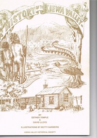 Kiewa Valley Historical Society
Book - A History of the Kiewa Valley, Kiewa Valley Historical Society, A History of the Kiewa Valley by Esther Temple and David Lloyd, Circa 1991
This book was compiled by Esther Temple and David Lloyd with illustrations by Betty Barberis and additional material provided by Clare Roper, Joan Macdonald, Wilma Davies and Nell Bateman. The book was first penned in 1971. It briefly covers the period from the indigenous tribes(broken down into family groupings) known as the "first Australians" who lived in the valley well before English settlers arrived. first white settlement (graziers, miners, stockmen) to smaller settlements.The development or transformation from a pristine(hunter/gatherer) valley environment to one that has been gradually changing to a more commercial rural/industrial landscaped valley. This transformation was made within a time span of two hundred years. The book details the first pioneers and their descendants, along with the changes to their environments both domestic and commercial. The book highlights dates and events that shaped the "feel" of the valley. The extreme hardships faced by pioneer families during the extremely isolated times away from "civilisation".This publication provides an insight to the struggles and victories against the harsh Australian bushland by people who had not been raised in such a sometimes inhospitable environment. It was this transformation which instilled into the Australian psyche of self sufficiency and the ability to grasp onto ideas or "bush" remedies to overcome enormous difficulties. It is is ability that has produced the many inventions useful in the 20th and 21st centuries.This book has a 250 g/m cream coloured cover with print and drawings of rural aspects of historical significance ( Aboriginal and early white settlers). The book contains 124 pages of black and white photographs(139), black and white sketches(75), two pages of sketches and freehand drawings, two freehand maps one county lease /subdivision plan and black and white printing. See KVHS 0237 (B) for the official invitation to the launch of the book.The front top cover heading(in shaded print and enclosed in a banner form) "A HISTORY OF THE KIEWA VALLEY" The bottom printing "BY ESTHER TEMPLE & DAVID LLOYD ILLUSTRATIONS BY BETTY BARBERIS" and at the very bottom "KIEWA VALLEY HISTORICAL SOCIETY" oN THE BOOK SPINE "A HISTORY OF THE KIEWA VALLEY.....BY ESTHER TEMPLE & DAVID LLOYD"early settlers, dederang, tawonga, mount beauty, sec vic hydro electricity, falls creek early settlers, bonegilla -
 City of Moorabbin Historical Society (Operating the Box Cottage Museum)
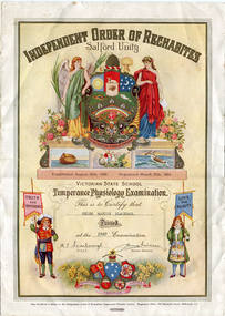
Certificate - Independent Order of Rechabites Certificate for Helen Blackman, 1949
Certificate issued by the Independent Order of Rechabites Temperance Friendly Society to Victorian state school children who had passed the temperance physiology examination. The Independent Order of Rechabites began in Salford, England in 1835. It was named after Rechab, a leader in the Old Testament, who instructed his tribe to refrain from drinking alcohol. During the Industrial Revolution the idea of temperance became popular as damage was caused to families by alcohol. In Australia it was first established in Tasmania in the mid 1800s. In 1847 a branch was created in Victoria, and it then spread to other States. Members were provided with assistance during times of sickness, death and hardship. The Victoria District of Rechabites (District No. 82) was established in the 28th January 1861 In its heyday the Victoria Rechabites’ membership numbers grew and grew to the extent that there were at one stage in excess of 36,000 members associated with the Victorian Rechabites in the late 1800’s to early 1900’s covering approximately 250 operating Tents. The certificate was issued to Helen Marion Blackman in 1949. Helen was a resident in the City of Moorabbin.Certificate issued by the Independent Order of Rechabites Temperance Friendly Society to Victorian state school children who had passed the temperance physiology examination. Independent Order of Rechabites - Salford Unityindependent order of rechabites, blackman, city of moorabbin, school children -
Whitehorse Historical Society Inc.
Pamphlet - Newsletter, Blackburn and District Tree Preservation Society, 26/01/1989 12:00:00 AM
Newsletter of the Blackburn and District Tree Preservation Society Inc.Newsletter of the Blackburn and District Tree Preservation Society Inc. Incomplete; for holdings see Box.Newsletter of the Blackburn and District Tree Preservation Society Inc.trees, blackburn and district tree preservation society, crouch, brian, smith, les, clayton, ann, hooke, bernard, mundell, tina, de waart, peter, edwards, margaret, schmit, lily, tribe, dianne, reid, wendy -
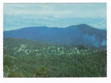 Marysville & District Historical Society
Postcard (item) - Colour postcard, Nucolorvue Productions Pty. Ltd, MARYSVILLE-Victoria, Pre 2009
A colour photograph of the view of Marysville from the Cumberland Range.A colour photograph of the view of Marysville from the Cumberland Range.The Cumberland Valley is notable for its giant mountain ash (Eucalyptus regnans) trees within the Cumberland Memorial Scenic Reserve, and relics from former sawmills and gold mining. The Big Culvert is located nearby on the Marysville-Woods Point Road, which was historically part of the Yarra Track. Cambarville, which is in the Cumberland Valley, was established as a timber mill town in the 1940s. Timber mill owners A Cameron and FJ Barton named Cambarville. They established the mill to salvage timber from trees destroyed in the 1939 bushfires. Cambarville was impacted by the 2009 Black Saturday bushfires and any remaining structures were destroyed. Barton's Lookout was named after a member of the Barton Family who were amongst Marysville's earliest pioneering families. This postcard was produced by Nucolorvue Productions as a souvenir of Marysville.Panorama of Marysville from/ Cumberland Range. NU-COLOR-VUE/ OF/ AUSTRALIA NUCOLORVUE PRODUCTIONS PTY. LTD./ COPYRIGHT PRINTED IN AUSTRALIA NCV 1658 POST CARD Dear Anne & tribe,/ Well as you can see,/ I'm here at Marysville./ This little surprise/ was waiting for me/ at the airport. We're/ here for a few days,/ & it's in the mountains/ outside Melb./ Traditionally it's/ a spot for Honeymooners./ There are lots of/ bush tracks &/ places to see and/ the hotel has a pool./ The weather is hot,/ 42 today so it/ is lovely to be out/ of Melb./ bye for now/ all my love/ illegiblemarysville, barton's lookout, victoria, nucolorvue productions, postcard, souvenir, cumberland valley, cumberland memorial scenic reserve, big culvert, marysville-wood's point road, yarra track, mining, timber mills, a cameron, fj barton, cambarville, 1939 bushfires, 2009 black saturday bushfires