Showing 1122 items
matching waterway
-
 Eltham District Historical Society Inc
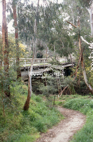
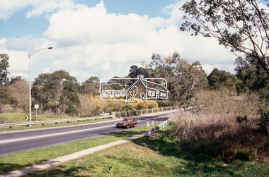
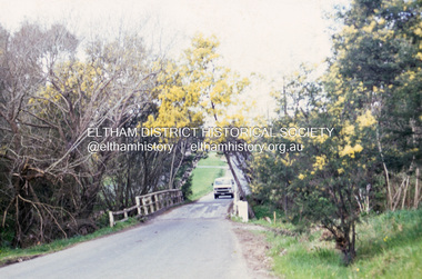
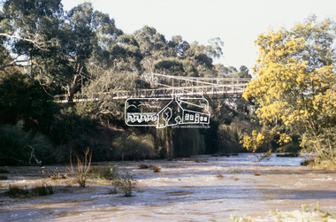
Slide - Photograph, Wattletree Road Bridge, Eltham, c.Sep. 1989
Part of a slide show presentation "Bridges & Waterways of the Shire" by Russell Yeoman to the 13 September 1989 Society meeting. The presentation included slides of historic photos from the Shire of Eltham Pioneers collections as well as several recent views.35mm colour positive transparency (1 of 33) Mount - Agfa CS System grey 8 dotsProcess Date Sep 1989wattletree road bridge, eltham -
 Eltham District Historical Society Inc
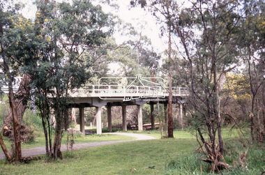
Slide - Photograph, Main Road Bridge, Eltham South, c.Sep. 1989
Part of a slide show presentation "Bridges & Waterways of the Shire" by Russell Yeoman to the 13 September 1989 Society meeting. The presentation included slides of historic photos from the Shire of Eltham Pioneers collections as well as several recent views.35mm colour positive transparency (1 of 15) Mount - Agfa CS System grey 8 dotseltham, main road bridge, eltham south -
 Eltham District Historical Society Inc
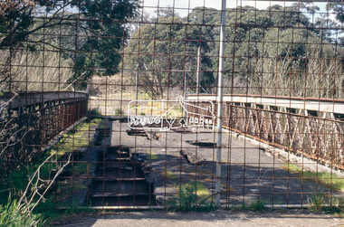
Slide - Photograph, Old Lower Plenty Bridge, c.Sep. 1989
Part of a slide show presentation "Bridges & Waterways of the Shire" by Russell Yeoman to the 13 September 1989 Society meeting. The presentation included slides of historic photos from the Shire of Eltham Pioneers collections as well as several recent views.35mm colour positive transparency (1 of 15) Mount - Agfa CS System grey 8 dotslower plenty bridge -
 Eltham District Historical Society Inc
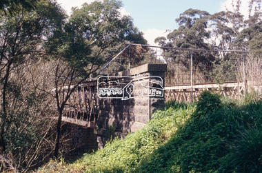
Slide - Photograph, New Lower Plenty Bridge, c.Sep. 1989
Part of a slide show presentation "Bridges & Waterways of the Shire" by Russell Yeoman to the 13 September 1989 Society meeting. The presentation included slides of historic photos from the Shire of Eltham Pioneers collections as well as several recent views.35mm colour positive transparency (1 of 15) Mount - Agfa CS System grey 8 dotslower plenty bridge -
 Eltham District Historical Society Inc
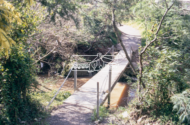
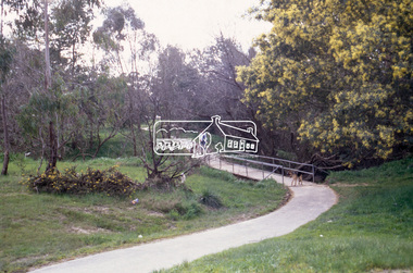
Slide - Photograph, Footbridge, Montmorency Park, c.Sep. 1989
Part of a slide show presentation "Bridges & Waterways of the Shire" by Russell Yeoman to the 13 September 1989 Society meeting. The presentation included slides of historic photos from the Shire of Eltham Pioneers collections as well as several recent views.35mm colour positive transparency (1 of 15) Mount - Agfa CS System grey 8 dotsfootbridge, montmorency park -
 Eltham District Historical Society Inc
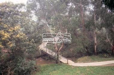
Slide - Photograph, Footbridge, George Court, Greensborough, c.Sep. 1989
Part of a slide show presentation "Bridges & Waterways of the Shire" by Russell Yeoman to the 13 September 1989 Society meeting. The presentation included slides of historic photos from the Shire of Eltham Pioneers collections as well as several recent views.35mm colour positive transparency (1 of 15) Mount - Agfa CS System grey 8 dotsfootbridge, george court, greensborough -
 Eltham District Historical Society Inc
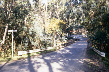
Slide - Photograph, Brougham Street Bridge, Eltham, c.Sep. 1989
Part of a slide show presentation "Bridges & Waterways of the Shire" by Russell Yeoman to the 13 September 1989 Society meeting. The presentation included slides of historic photos from the Shire of Eltham Pioneers collections as well as several recent views.35mm colour positive transparency (1 of 15) Mount - Agfa CS System grey 8 dotsbrougham street bridge, eltham -
 Eltham District Historical Society Inc
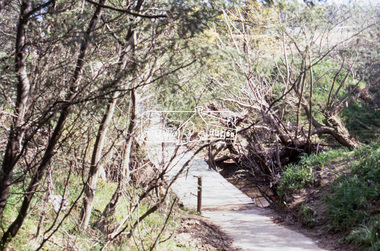
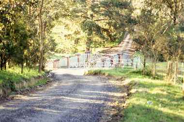
Slide - Photograph, Footbridge near Brougham Street, Eltham, c.Sep. 1989
Part of a slide show presentation "Bridges & Waterways of the Shire" by Russell Yeoman to the 13 September 1989 Society meeting. The presentation included slides of historic photos from the Shire of Eltham Pioneers collections as well as several recent views.35mm colour positive transparency (1 of 15) Mount - Agfa CS System grey 8 dotsbrougham street bridge, eltham, footbridge -
 Eltham District Historical Society Inc
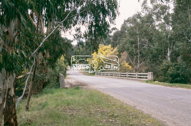
Slide - Photograph, Footbridge, Bridge Street, Eltham, c.Sep. 1989
Part of a slide show presentation "Bridges & Waterways of the Shire" by Russell Yeoman to the 13 September 1989 Society meeting. The presentation included slides of historic photos from the Shire of Eltham Pioneers collections as well as several recent views.35mm colour positive transparency (1 of 15) Mount - Agfa CS System grey 8 dotseltham, footbridge, bridge street -
 Eltham District Historical Society Inc
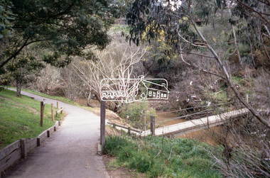
Slide - Photograph, Dalton Street Footbridge, Eltham, c.Sep. 1989
Part of a slide show presentation "Bridges & Waterways of the Shire" by Russell Yeoman to the 13 September 1989 Society meeting. The presentation included slides of historic photos from the Shire of Eltham Pioneers collections as well as several recent views.35mm colour positive transparency (1 of 15) Mount - Agfa CS System grey 8 dotseltham, footbridge, dalton street footbridge -
 Eltham District Historical Society Inc
Slide - Photograph, Footbridge, Odyssey House, Lower Plenty, c.Sep. 1989
Part of a slide show presentation "Bridges & Waterways of the Shire" by Russell Yeoman to the 13 September 1989 Society meeting. The presentation included slides of historic photos from the Shire of Eltham Pioneers collections as well as several recent views.35mm colour positive transparency (1 of 15) Mount - Agfa CS System grey 8 dotsfootbridge, lower plenty, odyssey house, yarra river -
 Eltham District Historical Society Inc
Slide - Photograph, Oxley Bridge, Henley Road, Kangaroo Ground, c.Sep. 1989
Part of a slide show presentation "Bridges & Waterways of the Shire" by Russell Yeoman to the 13 September 1989 Society meeting. The presentation included slides of historic photos from the Shire of Eltham Pioneers collections as well as several recent views.35mm colour positive transparency (1 of 15) Mount - Agfa CS System grey 8 dotsoxley bridge, henley road, kangaroo ground -
 Eltham District Historical Society Inc
Slide - Photograph, Aqueduct Bridge, Nicholas Lane, Kangaroo Ground, c.Sep. 1989
Part of a slide show presentation "Bridges & Waterways of the Shire" by Russell Yeoman to the 13 September 1989 Society meeting. The presentation included slides of historic photos from the Shire of Eltham Pioneers collections as well as several recent views.35mm colour positive transparency (1 of 15) Mount - Agfa CS System grey 8 dotskangaroo ground, aqueduct bridge, nicholas lane -
 Eltham District Historical Society Inc
Slide - Photograph, Lintons Bridge, Nutfield, c.Sep. 1989
Part of a slide show presentation "Bridges & Waterways of the Shire" by Russell Yeoman to the 13 September 1989 Society meeting. The presentation included slides of historic photos from the Shire of Eltham Pioneers collections as well as several recent views.35mm colour positive transparency (1 of 15) Mount - Agfa CS System grey 8 dotslintons bridge, nutfield -
 Greensborough Historical Society
Document - Report, Rhys Coleman, The Health of the Plenty River Catchment 1999, 1999_09
Report prepared by Rhys Coleman for Waterways and Drainage, Melbourne Water Corporation, discusses the health of the Plenty River catchment from upstream of Toorourrong Reservoir, through Whittlesea and Mernda, South Morang and Plenty to Greensborough and confluence with the Yarra River.31 p., tables.plenty river, melbourne water corporation -
 Eltham District Historical Society Inc
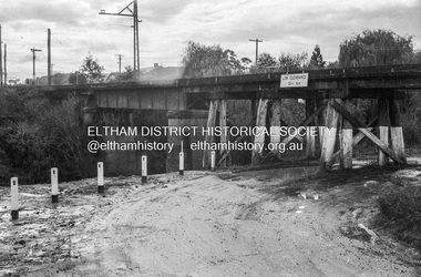
Photograph - Negative, Russell Yeoman, Railway Bridge across Plenty River near Railway Road, Briar Hill, Vic, c.1970
Part of a slide show presentation "Bridges & Waterways of the Shire" by Russell Yeoman to the 13 September 1989 Society meeting. The presentation included slides of historic photos from the Shire of Eltham Pioneers collections as well as several recent views.Roll of 35mm black and white negative film, 4 of 7 stripsIlford HP4bridge, greensborough, para road, plenty river, railway bridge -
 National Vietnam Veterans Museum (NVVM)
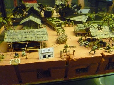
Model - Diorama, Cordon and Search
Diorama depicts a village with the huts / houses one covered storage area, two APC'S, Barrow with wood, pig pen,tunnels by three, boat on waterway and soldiers (searching for VC) Scenery includes trees and vegetation, wood piles and house hold items.C1967 Diorama is in two pieces joined by landing bridge.diorama -
 Lakes Entrance Historical Society
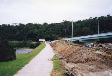
Photograph - Bridges, 2000
Date made May 2000.Colour photograph showing the removal of the road surface from the road approach and old concrete North Arm bridge prior to demolition of the bridge. Image shows the new bridge in background, earth moving machinery, and the North Arm waterway, and first rails of bridge removed by crane on bridge. Lakes Entrance Victoriabridges, waterways, demolition -
 Ringwood and District Historical Society
Newspaper, Scrapbook Clipping, Library Collection, Ringwood, Victoria
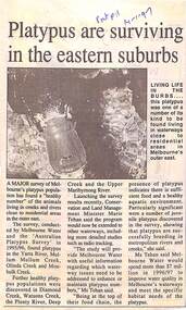
Newspaper Clipping from "The Post", 14 January 1997, Page 11, "Platypus are surviving in the eastern suburbs"'.A major survey of Melbourne's platypus population has found a "healthy number" of the animals living in creeks and rivers close to residential area in the outer east. Conservation and Land Management Minister, Marie Tehan, was present at the launching of the survey results, and spoke in detail about the results and the future planning and financial aid for the health of the Melbourne waterways. -
 Lakes Entrance Historical Society
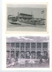
Photograph - The Lakes Entrance Hotel/Thomas Laughton, 1889
Lakes Entrance Hotel erected 1878 by Thomas Laughton Also second sketch of front of the hotel with 6 people on upper balcony Black and white photograph of a drawing of the Lakes Entrance Hotel. It shows a stylised view of a large weatherboard building with verandah across the main entrance with a viewing platform above. Horse drawn vehicle beside hotel, signal flagpole at front, a schooner and steamer in distant waterway. Lakes Entrance Victoria. Second sketch of front of hotelThe Lakes Entrance Hotel (immediately opposite the Southern Ocean Cunninghame) Edwin Stephenson Proprietor(under the patronage of the Governor Sir H B Lock K C B). buildings, hotels, genealogy -
 Lakes Entrance Historical Society
Photograph, Carpenter family, 1989
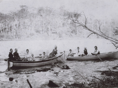
named are George Alfred Carpenter and sons Lionel 5 years and John Basil 4 years old seated in two rowing boats on a waterway which appears to be North Arm Lakes Entrance Victoria. The second and third phto are of George Carpenters house in BairnsdaleSepia toned photograph of eight adults and two young boys in boats including members of the Carpenter family . Also two other photos In the third photo "George Carpenters old home 'Thelma' East Bairnsdaslegenealogy, waterways, boats -
 Flagstaff Hill Maritime Museum and Village
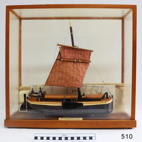
Craft - Ship model, 28-01-1985
This unnamed ship model was built by a Warrnambool resident. The Humber Keel design is typical sailing craft used for transport if inshore and inland cargo, from Humber and Hill, around Yorkshire, U.K. in late 19th and early 20th century. Ship model, single mast, double spar, humber keel. Two tone brown and cream paint, light brown sail. Figures of a man, woman and dog on deck. A type of vessel used on the Yorkshire waterways. Perspex case with wooden frame. Folded plans are inside case. Nameplate Plaque inside case describes ship."RIVER HUMBER KEEL/YORKSHIRE/LENGTH 61', BEAM 15'6", DR G CAP 100 TONS/CREW MAN & WIFE, SCALE 1:40/HUON PINE etc. E.H. GRANGER 28.1.1985" on plaque inside caseflagstaff hill, warrnambool, shipwrecked-coast, flagstaff-hill, flagstaff-hill-maritime-museum, maritime-museum, shipwreck-coast, flagstaff-hill-maritime-village, humber keel, sailing cargo -
 Bendigo Historical Society Inc.
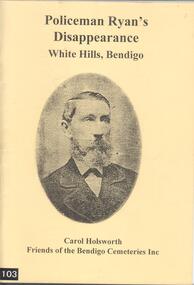
Book - BOOK: POLICEMAN RYAN'S DISAPPEARANCE WHITE HILLS, BENDIGO BY CAROL HOLSWORTH FRIENDS OF THE BENDIGO CEMETERIES INC, 2013
Thomas Ryan (1824-1866) was a constable at White Hills when he disappeared after visiting the Chinese Camp. Despite vigorous searching including the dragging of many waterways, no trace of his body was ever found. He had married Johanna Carroll (1839-1889) in 1860.Softcover book with yellow cover and a black and white photograph of Policeman Thomas Ryan. Contains 79 pages with Contents list, diagrams and photographs. Tells the story of the disappearance of Thomas RyanCarol Holsworthperson, police, constable ryan -
 Flagstaff Hill Maritime Museum and Village
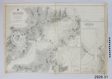
Document - Navigation Chart, British Admiralty, Otago Harbour, Late 19th to Early 20th century
Navigation charts are used by mariners around the world for navigating waterways. This chart was created for Otago Harbour in New Zealand. A ship "Otago' was named after this harbour and was once commanded by renowned maritime author Joseph Conrad. That ship now lies in Otago Bay, in the Derwent River, Tasmania.This navigation chart was published by the British Admiralty cartographer, to aid mariners to navigate the world's water bodies. Navigation charts are still used today, along with other navigational instruments.British Admiralty Navigation Chart - Otago Harbour, South Island, New Zealand. Chart shows insets with finer detail of important sections.warrnambool, shipwrecked-coast, flagstaff-hill, flagstaff-hill-maritime-museum, maritime-museum, shipwreck-coast, flagstaff-hill-maritime-village, shipwrecked-artefact, british admiralty navigation chart, navigation chart, british admiralty, otago harbour, south island, new zealand, otago bay, derwent river, tasmania, joseph conrad -
 Eltham District Historical Society Inc
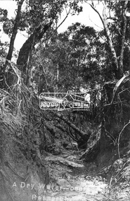
Negative - Photograph, Tom Prior, A Dry Water-course - Research, Vic, c.1895
This water course starts at Mount Pleasant Road, Research. Part of a slide show presentation "Bridges & Waterways of the Shire" by Russell Yeoman to the 13 September 1989 Society meeting. The presentation included slides of historic photos from the Shire of Eltham Pioneers collections as well as several recent views.This photo forms part of a collection of photographs gathered by the Shire of Eltham for their centenary project book,"Pioneers and Painters: 100 years of the Shire of Eltham" by Alan Marshall (1971). The collection of over 500 images is held in partnership between Eltham District Historical Society and Yarra Plenty Regional Library (Eltham Library) and is now formally known as the 'The Shire of Eltham Pioneers Photograph Collection.' It is significant in being the first community sourced collection representing the places and people of the Shire's first one hundred years. The Reynolds family were early settlers in Research. The Reynolds/ Prior collection of photographs were taken by Tom Prior, the maternal uncle of Ivy Reynolds, around 1900 and the 60 photos in the album give a fine overview of many of the landmarks of Research and Eltham over 100 years ago. lvy lived in the family home for many years at 106 Thompson Cres Research. Ivy's father, Ernst Richard Reynolds and grandfather, Richard Reynolds, lived at the same address. Ivy's father Richard worked for Mr. Trail on his property in Research. Reynolds Road is named after the family. Mr Tom Prior (wife Eva) worked at the Melbourne zoo. He was very innovative and made his own camera, using the black cloth hood to exclude the light. The photographs are a reminder of the rural nature of Research and Eltham and its rich heritage.Digital image 4 x 5 inch B&W Negshire of eltham pioneers photograph collection, research (vic.), creek, mount pleasant road, reynolds prior collection -
 Wangaratta High School
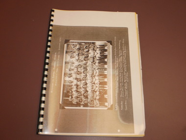
WHS Magazine -Korrumbeia, 1952
This is the transition year as the Wangaratta High school magazine is renamed to Korrumbeia. Korrumbeia is Victorian aboriginal term meaning restful river/creek (Kurrabi; creek, Umina; rest, Beeia; river) This is a reference to the Ovens and King rivers merging in Wangaratta, and the fact that WHS houses are named after local waterways.Black and white photocopy of the 1952 edition of Korrumbeia featuring a large image of the interschool sports athletics team -
 Ringwood and District Historical Society
Pamphlets, Maroondah / Ringwood: Various leaflets about local organisations and events, primarily Arts related. 2004-2008, 2004 - 2008
Various leaflets about local organisations and enterprises:; 1. Summer series 2007-2008;; 2. 2004 Maroondah - Winter Arts Festival;; 3. Parks and Paths Maroondah;; 4. Waterways of Maroondah;; 5. Maroondah Movement for Reconciliation Inc 2008; 6. Maroondah Art Gallert Program 2007; 7. Disabled Persons Craft and Display Fair 1981. -
 Lakes Entrance Historical Society
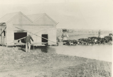
Photograph - Bullock Team c1900, East Gippsland Victoria, 1900 c
Black and white photograph showing a bullock team transporting a building through a waterway under the watchful eye of two men one on horse back while an older man looks on, flat terrain East Gippsland Victoria..Also a second back and white photograph of a bullock team towing a timber building on a trailer along a road cutting in Gippsland transport, buildings