Showing 27689 items
matching yarra-river
-
 Melbourne Tram Museum
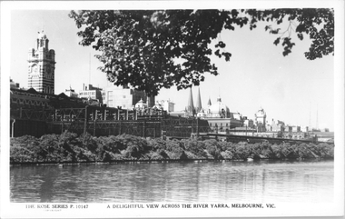
Postcard, Rose Stereograph Co, "A delightful view across the River Yarra, Melbourne"
Rose Series postcard No. P 10147, titled "A delightful view across the River Yarra, Melbourne" showing a view from the south bank of the Yarra across to Flinders St station, the signal gantries at the west end of the platforms, the station buildings and some of the other buildings on the skyline. A St Kilda bound dog box (swing door) set is in platform 10 awaiting departure.Yields information Flinders St station from the south side of the river.Postcard - printed real photograph with Rose Stereograph Co. name on the rear.flinders st station, signals, yarra river, railways, electric trains -
 Eltham District Historical Society Inc
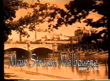
Film - Video (VHS), Screen Sound Australia, Main Stream Melbourne - The River Yarra on film and The Prize by Tim Burstall, 2004
Main Stream Melbourne - The River Yarra on film (Screen Sound Australia, 2004) and The Prize (Eltham Films, Tim Burstall ,1960) Combining footage from more than 90 early newsreels, documentaries and short films which additionally features almost 200 photographs and illustrations - shows locals fishing and swimming in the river, holding canoe races and lazing at boathouses. Also included is Tim Burstall's 1960 short film, The Prize, which tells the story of a boy, played by his then six-year-old son Tom, and his adventures with a kid goat. The film, shot on the Yarra, won a bronze award at the 1960 Venice Film Festival. Of specific interest, scenes from Warrandyte, Montsalvat footage from 1965, Heidelberg School Artists' Trail, Koornung School (1947) in North Warrandyte, Tim Burstall and The Prize (1960) with scenes on Brougham Street Bridge, and Yarra River scenes at Morrison's Breakwater at Eltham and the Bend of Isles at Kangaroo Ground.VHS Video cassette, 130 minutes. Converted to MP4 file format 02:16:11, 1.54GBthe prize (film), tim burstall, yarra river, warrandyte, brougham street bridge, montsalvat, bend of islands, heidelberg school artists trail, koornong school, morrisons breakwater, video recording -
 Melbourne Tram Museum
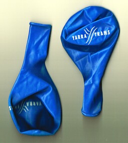
Souvenir - Event Materials, Yarra Trams, Yarra Trams balloons, 2000's
Blue latex rubber balloon - with the words "Yarra Trams" printed on it. Not known which event or when.trams, tramways, yarra trams, events -
 Lakes Entrance Historical Society
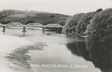
Postcard - Tambo River bridge at Bruthen Victoria, H D Bulmer
Ringbarked trees on hill in background and willows along river bankBlack and white postcard of bridge over the Tambo River at Bruthen Victoria'TAMBO RIVER BRIDGE AT BRUTHEN'agriculture, rivers, bridge -
 Melbourne Tram Museum
Document - Folder with papers, Yarra Trams, "The KDR Yarra Trams Employee Roadshow Program", Oct. 2009
Folder - colour printed with various documents, part of the "The KDR Yarra Trams Employee Roadshow Program", Keolis Downer - EDI, when they took over Yarra Trams in November 2009. Has 9 separate fact A4 sheets and one folded pamphlet "Think like a passenger" Fact Sheets for: 1. Employee Roadshow program - gives dates. 2. KDR and Yarra Trams 3. Enhancing Performance 4 Delivering for Passengers 5. Customer Service 6. Find your way 7. Yarra Trams Employees 8. A new approach 9. Brand Re-fresh The "Think like a passenger" is a folded DL pamphlet, giving information about KDR and the work they planned to do the tram fleet. Has a message from Michel Masson, the CEO of Yarra Trams on the rear.trams, tramways, keolis, kdr, yarra trams -
 Kew Historical Society Inc
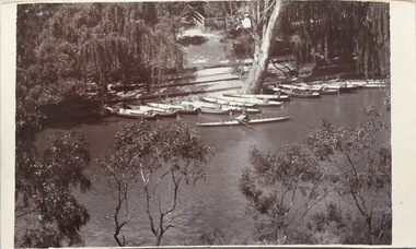
Postcard, Macauleys' Boat Shed on the River Yarra at Kew, 1907-1915
The Kew Historical Society's postcard collection includes views of Kew, Melbourne and Greater Melbourne as well as those including overseas scenes sent or received from Europe or the Middle East. They date from the 1890s to the 2000s. These postcards may or may not include the name of the publisher or printer. A number of the cards were published as parts of popular series. A way of dating early postcards is to identify whether the reverse was divided by a central line which became the norm after 1902 in the United Kingdom. However, other postcards produced after this date do not always conform to this print layout.The item forms part of the Laurie Bennett collection of thirty-six postcards and photographs of Kew and early Melbourne, donated to the Kew Historical Society in 1980. The postcards in the Bennett collection, like other images in the Society's holdings date from the 1890s to the present and comprehensively indicate points-of-view or scenes considered historically, aesthetically or socially significant in the period in which they were produced.Monochrome photo postcard of Macauleys' Boat Shed in Kew and its position on the Yarra at the end of Molesworth Street."KH-393. Macauley's Boat Shed, Kew. Lower Molesworth St, Donated by L. Bennett"boat sheds - kew (vic), river yarra - kew (vic), macaulay's boat shed - kew (vic), recreation - yarra river - kew (vic) -
 Melbourne Tram Museum
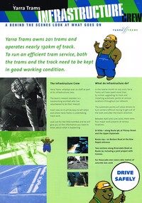
Pamphlet, Yarra Trams, "Yarra Trams - Infrastructure Crew", mid to late 2000
Pamphlet - A4 - printed full colour on both sides titled "Yarra Trams - Infrastructure Crew", a behind the scenes look at what goes on. Notes Yarra trams "owns" 201 trams and 130km of track. Notes recent work between April and June 2000 on various projects. Has photos of various projects, uses the image of "Harry the Wombat" logo. Has the Yarra Trams logo and the contact numbers. Two copies held.trams, tramways, yarra trams, trackwork, track repairs, level crossings, tramway per way -
 Eltham District Historical Society Inc
Negative - Photograph, ‘Worlingworth’, Yarra River, Eltham
‘Worlingworth’, Yarra River, Eltham Original homestead on the property ‘Worlingworth’, a large residence and surrounding farm site standing on a knoll above the River Yarra in Banoon Road, Eltham. The present house was built about 1922 and was originally owned by Mr A.R. Read, a stock and station agent and member of the Stock Exchange (who left the district in early 1926 to take up permanent residence at his Warburton property). It became the home of notable anthropologist Prof. Dr. Donald Thomson (1901-1971) and Mrs. Gladys Thomson who were married in 1925 and had twin sons in 1934 and is considered historically and aesthetically significant to the Shire of Nillumbik.This photo forms part of a collection of photographs gathered by the Shire of Eltham for their centenary project book, "Pioneers and Painters: 100 years of the Shire of Eltham" by Alan Marshall (1971). The collection of over 500 images is held in partnership between Eltham District Historical Society and Yarra Plenty Regional Library (Eltham Library) and is now formally known as 'The Shire of Eltham Pioneers Photograph Collection.' It is significant in being the first community sourced collection representing the places and people of the Shire's first one hundred years.Digital image 4 x 5 inch B&W Negshire of eltham pioneers photograph collection, a.r. read, banoon road, donald thomson, eltham, gladys thomson, worlingworth, yarra river -
 Melbourne Tram Museum
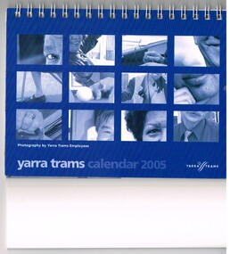
Ephemera - Calendar, Yarra Trams, "Yarra trams calendar 2005", 2004
Desk Calendar - 2005 - wire spiral bound along top edge, gloss paper, with cover and each month featuring various Yarra Trams employees and with photographs by employees. Names listed in key Associations. Concept by Darren Gladstone. Celebrates the diverse family of Yarra Trams employees.trams, tramways, yarra trams, calendar, employees, drivers -
 Lakes Entrance Historical Society
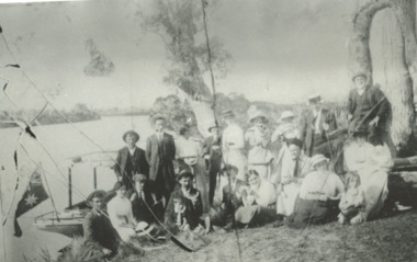
Photograph, Phillip Hancock, Howlett, Legg, Froud, Bly, Brideson, Bull, Bell, Thompson, Wilson Families on the bank of the Tambo River Gippsland Victoria, January 1915 c
James, Maud, Eva, May, Mabel Howlett, Fred, Marion, Alf, Gladys Legg, Carrie Froud, Jessie Bly, Lena Brideson, George Bull, Will Bell, Jim Thompson, Mr Wilson on the bank of the Tambo River Gippsland VictoriaBlack and white photograph showing small launch beside river and large Aboriginal canoe tree in background and eighteen adults and two children, genealogy, families -
 Melbourne Tram Museum
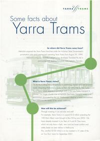
Pamphlet, Yarra Trams, "Some facts about Yarra Trams", Sep. 1999
Pamphlet - A4 double sided with a watermarked image of V 214 on both sides, titled "Some facts about Yarra Trams". Gives background to Yarra Trams franchise commencing 29/8/1999, Transdev, their vision, extension of route 109, new trams, routes operated and staff.trams, tramways, yarra trams, franchising, route 109, transdev, c class, tram v214 -
 Greensborough Historical Society
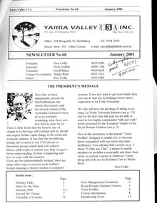
Document - Newsletter, Yarra Valley U3A, Yarra Valley U3A Newsletter, nos. 60, Jan 2001 and 66 Jan 2003, 2001 - 2003
Newsletter listing classes, courses, events and locations available in 2001and 2003 at Yarra Valley U3A, Burgundy Street Heidelberg.Black and white print both sides, 12-14 p., staplednon-fictionyarra valley u3a -
 Orbost & District Historical Society
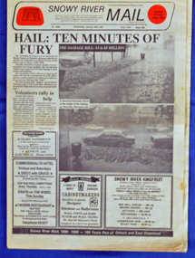
newspaper, Snowy River Mail, 30.1.1991
On 24 January 1991 a severe hailstorm occurred in Orbost. The Insurance Council of Australia estimated the 1991 damage at $12 million. This newspaper records contemporary accounts of significant local events.A Snowy River Mail newspaper, dated 30.1.1991. the main article relates to the severe hail storm in Orbost on January 24, 1991. The newspaper contains news articles, photographs and advertisements.hail-storm-orbost-1991 snowy river mail -
 Greensborough Historical Society
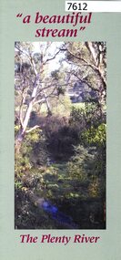
Pamphlet, Friends of the Plenty River, "a beautiful stream": The Plenty River, 2004_04
A publicity pamphlet for "Friends of the Plenty River", a group formed in 1995 to help rehabilitate the Plenty River and adjacent land.2 p., illus., map. Tri-fold pamphlet.plenty river, lower plenty, friends of the plenty river -
 Kew Historical Society Inc
Photograph, J F C Farquhar, Railway Bridge Over the Yarra, 1891
At the beginning of the 1890s, the Kew businessman and Town Councillor, Henry Kellett, commissioned J.F.C. Farquhar to photograph scenes of Kew. These scenes included panoramas as well as pastoral scenes. The resulting set of twelve photographs was assembled in an album, Kew Where We Live, from which customers could select images for purchase.The preamble to the album describes that the photographs used the ‘argentic bromide’ process, now more commonly known as the gelatine silver process. This form of dry plate photography allowed for the negatives to be kept for weeks before processing, hence its value in landscape photography. The resulting images were considered to be finely grained and everlasting. Evidence of the success of Henry Kellett’s venture can be seen today, in that some of the photographs are held in national collections.It is believed that the Kew Historical Society’s copy of the Kellett album is unique and that the photographs in the book were the first copies taken from the original plates. It is the first and most important series of images produced about Kew. The individual images have proved essential in identifying buildings and places of heritage value in the district.Completed in November 1890, the railway viaduct (now the Chandler Highway Bridge) linked Kew and Fairfield. The viaduct is significant as the most substantial extant engineering remnant of the Outer Circle Railway Line. Opened in March 1891, the viaduct crossed the Yarra River in a single span, atop three supporting brick pillars. Following the closure of the railway line in 1927, and the construction of the Chandler Highway in 1930, the bridge was used for vehicular traffic. In 1891 when this panoramic photograph was taken, the grounds of what was then the Kew Lunatic Asylum extended down to the River and eastward beyond the viaduct. The landscape surrounding the Asylum was planted with traditional exotic trees such as Oaks, Pines and Cedars, and landmark trees from northern Australia such as the Hoop Pine. Remnant indigenous trees such as the River Red Gum, Yellow Box and Lightwood were scattered around the site, including beside the Yarra River.Railway Bridge Over the Yarrakew illustrated, kew where we live, photographic books, henry kellett, railway viaduct - - kew (vic) -
 Orbost & District Historical Society
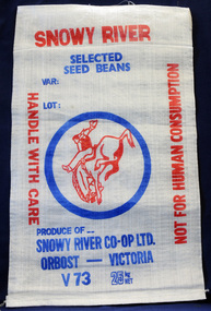
seed bag, mid 20th century
This unused bag would have been used by the snowy River Co-Op in Orbost during the 1960's-1970's to pack selected seed beans.Snowy River Seeds started life as a farmers' co-operative (Snowy River Co-op) in 1967. This item is significant because it was specially made for the seed bean industry which was a major industry in the Orbost district for over a century. A bag made of white woven synthetic material. It is unused. On the front is the logo for the Snowy River Co-Op Ltd - the 'man from Snowy River" in red print inside a blue circle. Other print is red and blue.On front: Produce of... Snowy River Co-Op Ltd Orbost - Victoria V73 25 kg NET snowy-river-co-op seed-bag -
 Melbourne Tram Museum
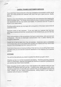
Document - Instruction, Yarra Trams, "Yarra Trams Customer Service", 1997?
.Instruction or guidelines, 15 A4 sheets stapled in the top left hand corner, titled "Yarra Trams Customer Service", training document on providing good service to customers, especially on the phone, produced by Paul Matthews, Marketing Manager for Yarra Trams - 1997? H as extracts from various training documents on handling stress, customers on the phone, and behaviour.trams, tramways, training, yarra trams, marketing -
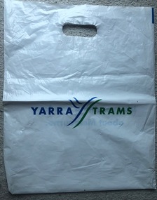 Melbourne Tram Museum
Functional object - Plastic bag, Yarra Trams, "Yarra Trams", c2000
White plastic bag with carry hole punched printed with the words "Yarra Trams" and on the other side "It's everything you love about Melbourne."trams, tramways, yarra trams, stationery, commerce -
 Port Fairy Historical Society Museum and Archives
Postcard, The Rose Series / The Rose Stereographs, The Moyne River and bridge Port Fairy
Post card of the Moyne River BridgeBlack and white photograph of the Moyne river and Bridgehe Rose Series P. 10810 The Moyne River and Bridge, Port Fairybridge, moyne river, traffic, road -
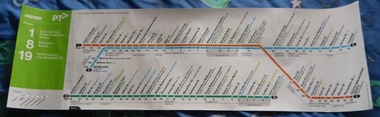 Melbourne Tram Museum
Poster, Yarra Trams, "Route poster - Yarra Trams - Routes 1, 8 and 19", 2012
Full colour poster printed on a vinyl plasticized based with adhesive backing sheet titled "Route poster - Yarra Trams - Routes 1, 8 and 19." Gives a map layout for the three routes, most stops, shows the Melbourne CBD, connecting services, Yarra trams logo, accessible stops. On right hand end, has the poster details and date of November 2012.trams, tramways, yarra trams, routes, maps, north coburg, moreland, toorak, south melbourne -
 Eltham District Historical Society Inc
Photograph, Fay Bridge, Ancient Eel trap on the Yarra River at Laughing Waters, Eltham - pre-dating European settlement, 6 September 2023
Laughing Waters is the name for a stretch of the Yarra Valley Parklands consisting of river flats and hilly riparian bushland. With Birrarung (Yarra River) flowing through, Laughing Waters has been an important gathering place for thousands of years. For the Wurundjeri, ‘Garambi Baan’ (the name for Laughing Waters in Woi wurrung) is an important site for growing and harvesting food. Significantly, Wurundjeri iuk (eel) traps remain at Garambi Baan to this day. The Wurundjeri Woi Wurrung People take their name from the Woi wurrung language word ‘wurun’ meaning the Manna Gum (Eucalyptus viminalis) which is common along ‘Birrarung’ (Yarra River), and ‘djeri’, the grub which is found in or near the tree. Wurundjeri are the ‘Manna Gum People’ and their Ancestors have lived on this land for millennia. The site on the Yarra River near the former Morrison property Killeavey was given a language name in 2015 at the instigation of Wurundjeri Elder, Dave Wandin. Garambi Baan means “laughing waters” in the traditional language, Woi wurrung. The site at Warrandyte was rediscovered by Campbell Beardsell OAM in 2007 and is one of only a few known remaining iuk (eel) traps on Country once found the length of the Birrarung (Yarra) and the Maribyrnong. Original Indigenous aquacultural infrastructure was dismantled, taken away from sites and used to build houses, fords and roads by Europeans. The difficult and restricted access to this site is thought to be one of the reasons for its survival. The iuk trap is located within lands managed by Parks Victoria. The Narrap team in partnership with Parks Victoria and Acacia Land Management have been improving the native vegetation with a program of woody weed removal, exclusion fencing and revegetation. Importantly, the team have restored the trap’s infrastructure and have demonstrated its effectiveness.” References: Wurundjeri Woi Wurrung Cultural Heritage Aboriginal Corporation - Laughing Waters. (2023, September 3). Retrieved from https://inplace.org.au/laughing-waters/ GARAMBI BAAN LAUGHING WATERS RESIDENCY CENTRE 2020 2024 Strategic Plan, Nillumbik Shire Council (2023, September 3). Retrieved from https://www.nillumbik.vic.gov.au/files/assets/public/minutes-and-agendas/2020/09-sep/15-sep-cm/ocm.177-20-attachment-1-laughing-waters-arts-program_1.pdffay bridge collection, eel trap, laughing waters, yarra river, wurundjeri woi wurrung, garambi baan, 2023-09-06 -
 Eltham District Historical Society Inc
Photograph, Fay Bridge, Ancient Eel trap on the Yarra River at Laughing Waters, Eltham - pre-dating European settlement, 16 May 2015
Laughing Waters is the name for a stretch of the Yarra Valley Parklands consisting of river flats and hilly riparian bushland. With Birrarung (Yarra River) flowing through, Laughing Waters has been an important gathering place for thousands of years. For the Wurundjeri, ‘Garambi Baan’ (the name for Laughing Waters in Woi wurrung) is an important site for growing and harvesting food. Significantly, Wurundjeri iuk (eel) traps remain at Garambi Baan to this day. The Wurundjeri Woi Wurrung People take their name from the Woi wurrung language word ‘wurun’ meaning the Manna Gum (Eucalyptus viminalis) which is common along ‘Birrarung’ (Yarra River), and ‘djeri’, the grub which is found in or near the tree. Wurundjeri are the ‘Manna Gum People’ and their Ancestors have lived on this land for millennia. The site on the Yarra River near the former Morrison property Killeavey was given a language name in 2015 at the instigation of Wurundjeri Elder, Dave Wandin. Garambi Baan means “laughing waters” in the traditional language, Woi wurrung. The site at Warrandyte was rediscovered by Campbell Beardsell OAM in 2007 and is one of only a few known remaining iuk (eel) traps on Country once found the length of the Birrarung (Yarra) and the Maribyrnong. Original Indigenous aquacultural infrastructure was dismantled, taken away from sites and used to build houses, fords and roads by Europeans. The difficult and restricted access to this site is thought to be one of the reasons for its survival. The iuk trap is located within lands managed by Parks Victoria. The Narrap team in partnership with Parks Victoria and Acacia Land Management have been improving the native vegetation with a program of woody weed removal, exclusion fencing and revegetation. Importantly, the team have restored the trap’s infrastructure and have demonstrated its effectiveness.” References: Wurundjeri Woi Wurrung Cultural Heritage Aboriginal Corporation - Laughing Waters. (2023, September 3). Retrieved from https://inplace.org.au/laughing-waters/ GARAMBI BAAN LAUGHING WATERS RESIDENCY CENTRE 2020 2024 Strategic Plan, Nillumbik Shire Council (2023, September 3). Retrieved from https://www.nillumbik.vic.gov.au/files/assets/public/minutes-and-agendas/2020/09-sep/15-sep-cm/ocm.177-20-attachment-1-laughing-waters-arts-program_1.pdffay bridge collection, 2015-05-16, eel trap, laughing waters, yarra river, wurundjeri woi wurrung, garambi baan -
 Melbourne Tram Museum
Document - Press Release, Yarra Trams, "Yarra Trams 2006 - 100 Years of electric trams - Press Pack", Aug. 2006
Series of three items contained with Reg item 2400, a Folder with papers, titled "Yarra Trams 2006 - 100 Years of electric trams - Press Pack", issued 10 August 2006 by Yarra Trams and Siemens for the centenary celebrations of electric trams .1 - Bookmark - longitudinal or side on view of the Centenary Art Tram - 5006 - with the 100 years, Yarra Trams and Siemens logos. Three copies held. .2 - Have a coffee on us postcard with images of the various trams on the side of the tram and a voucher stapled to the sheet for a free coffee at Hudson's. .3 - Press or Media release for the launch of the Centenary Art Tram dated Thursday 10 August 2006 - quotes Dennis Cliche - two sheets with an image of 5006 on the second sheet. Has contact details for further information - Naomi Helleren of Yarra Trams and Joanne Woo of Siemens.trams, tramways, 100 years of electric trams, combino, siemens, yarra trams, decorated trams, tram 5006 -
 Kew Historical Society Inc
Photograph, J F C Farquhar, The Yarra in Hyde Park, 1891
At the beginning of the 1890s, the Kew businessman and Town Councillor, Henry Kellett, commissioned J.F.C. Farquhar to photograph scenes of Kew. These scenes included panoramas as well as pastoral scenes. The resulting set of twelve photographs was assembled in an album, Kew Where We Live, from which customers could select images for purchase.The preamble to the album describes that the photographs used the ‘argentic bromide’ process, now more commonly known as the gelatine silver process. This form of dry plate photography allowed for the negatives to be kept for weeks before processing, hence its value in landscape photography. The resulting images were considered to be finely grained and everlasting. Evidence of the success of Henry Kellett’s venture can be seen today, in that some of the photographs are held in national collections.It is believed that the Kew Historical Society’s copy of the Kellett album is unique and that the photographs in the book were the first copies taken from the original plates. It is the first and most important series of images produced about Kew. The individual images have proved essential in identifying buildings and places of heritage value in the district.Hyde Park is now a small recreation reserve bordered by Willsmere and Kilby Roads and White Avenue. In 1982, Hyde Park was cut off from the Yarra River by the construction of the Eastern Freeway. The building of the latter was to transform the natural landscape, including the Yarra, as well as Hyde Park. The construction of the Freeway makes it difficult to view the scene with the photographer’s eye. Today’s Hyde Park is located on land purchased in 1847 by John Cowell, and in 1851 Catherine Cowell, yet the scene selected by the photographer may well have been located on farmland owned by the Wills family. Farquhar’s point-of-view emphasises both the pastoral and recreational elements of the scene: the grazing cows, three boys, and in the distance two figures, seated on the bank with a parasol. By 1891, an environmental consequence of human activity, including farming, was deforestation, leading to the erosion of the south bank of the Yarra. In contrast, the land on the Alphington side of the river in 1891 included remnant bushland.The Yarra in Hyde Parkkew illustrated, kew where we live, photographic books, henry kellett, yarra river -
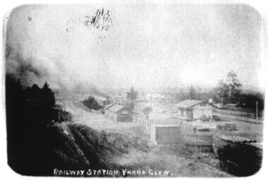 Yarra Glen & District Historical Society
Sepia postcards, Railway Station Yarra Glen
Faded sepia photograph of the Yarra Glen Railway Station taken from a point south west of the buildings. In the centre of the photograph is the railway station and platform. To the right is a goods shed. In the background is 'River View'.On the back at the top "POST CARD". Below that is "FOR CORRESPONDENCE" to the left and "FOR ADDRESS ONLY" to the right. Centre right is a stamp "YARRA GLEN/Mrs. E. Smith/SYMONDS STREET/YARRA GLEN 3775"yarra glen, river view, yarra glen railway station, railway station, railway platform, goods shed -
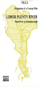 Greensborough Historical Society
Pamphlet, Melbourne & Metropolitan Board of Works, Lower Plenty River: Yarra River to Greensborough: preparation of a concept plan, 1990
This pamphlet outlines a proposed concept plan for the lower Plenty River, Greensborough to Heidelberg. The plan would focus on preserving and enhancing the aesthetic, recreational and conservation potential of the waterway.2 p., illus., tri-fold pamphlet. 2 copiesplenty river, melbourne water corporation, board of works -
 Melbourne Tram Museum
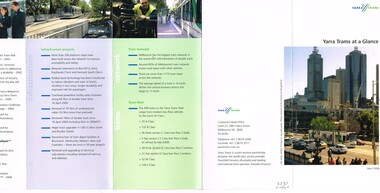
Pamphlet, Yarra Trams, "Yarra Trams at a Glance", Apr. 2008
Pamphlet - DL size, 5 fold printed in full colour on white paper, titled "Yarra Trams at a Glance". Gives details of the services, staff, state projects, tram fleet upgrade, innovation, Tram Tracker, awards, infrastructure projects, the network, tram fleet and contact details. Has the logos of Yarra Trams - Dated April. 2008. See Reg Item 1124 for the Oct. 2008 issue. Two copies held.trams, tramways, yarra trams, logos, tramcars, information -
 Melbourne Tram Museum
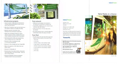
Pamphlet, Yarra Trams, "Yarra Trams at a Glance", Oct. 2008
Pamphlet - DL size, 5 fold printed in full colour on white paper, titled "Yarra Trams at a Glance". Gives details of the services, staff, state projects, tram fleet upgrade, innovation, Tram Tracker, awards, infrastructure projects, the network, tram fleet and contact details. Has the logos of Yarra Trams, TransdevTSL and Tram Tracker. Dated Oct. 2008. See Reg item 2397 for an April 2008 issuetrams, tramways, yarra trams, transdev, logos, tramcars, information -
 Melbourne Tram Museum
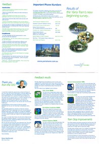
Pamphlet, Yarra Trams, "Results of the Yarra Tram's new beginning survey", c1998
Pamphlet - DL - 3 fold, full gloss paper titled" Results of the Yarra Tram's new beginning survey" Looks at the results of a survey, both construction (eg maps, shelters, stop announcements), compliments etc. Main items were having daily tickets available on trams, re-introduce conductors, improve frequency, announcements and punctuality. Has a message from the CEO of Yarra at the time, Steve MacDonald. Two copies held.trams, tramways, yarra trams, surveys, conductors, tickets, tram stops -
 Melbourne Tram Museum
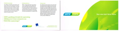
Pamphlet, Yarra Trams, "Your new look Yarra Trams", Nov. 2009-2010
Pamphlet - 4 fold horizontal format, full quarto, titled "Your new look Yarra Trams" following the takeover of the former operator Keolis Downer/EDI rail in late 2009, featuring the new Yarra Trams logo and the terms "think like a passenger", "moving safe haven" and "find your way" - has a sample of the Route 112 route map. Also features the new look trams and the Keolis/Downer - EDI rail logo.trams, tramways, yarra trams, kdr, logos